
The Maddening Mystery of Dorset Field Club
By Mike Cirba
A critical examination of the evidence supporting the club’s claim to be the oldest golf course in the United States.
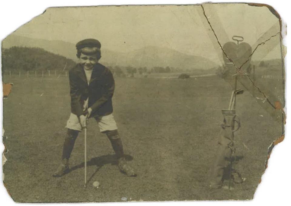
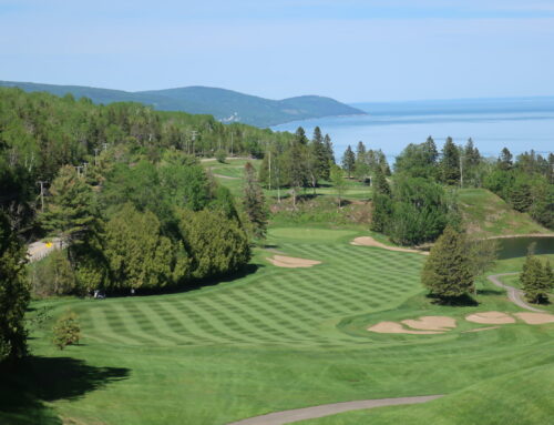
A strong sense of tradition and timelessness pervades the Dorset Field Club where tennis, golf, and croquet are featured
If you were to create a mythical town where golf has been played longest in the United States it would likely look something like the lovely hamlet of Dorset, Vermont. Set in a story-book valley between the Taconic and Green Mountain ranges, everything smacks of New England propriety and cleanliness, and time moves with particular slowness here.
A town of bright white homes and painted green shutters with nearby abandoned marble quarries that enriched the town’s forefathers now serving as swimming holes, Dorset is home of the founding of the state of Vermont and occupies the highest valley between New York City and Montreal, Canada. Nineteenth century physicians recommended these clean, cool environs as restorative havens from crowded, polluted cities and a cottage community was formed here in the late 1800’s as well-heeled folks from Albany, and Troy, and New York City annually “summered” here.
The golfing lore that’s been passed down goes something like this; a bunch of summering Trojans (that included Scottish immigrants who grew weary of being unable to play their native game in America)
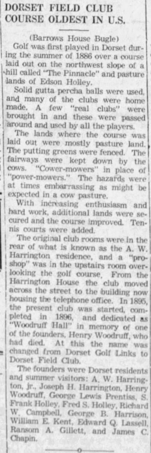
began to look for something more engaging than tennis and lawn croquet. One of them named George B. Harrison had a single golf club (purportedly from Scotland) that they would use to drive makeshift balls but soon they yearned for the real thing. A man by the name of Arvin Wood Harrington, Jr. gathered a group near his summer home and spent the afternoon of Sunday, September 12th, 1886 laying out a nine-hole golf course of 1,892 yards across three neighboring pastures. The spark was lit and the game soon spread like wildfire across the summer community and shortly Mr. Harrington learned the art of club-making, fashioning various implements for his friends and neighbors who used his home as a makeshift clubhouse.
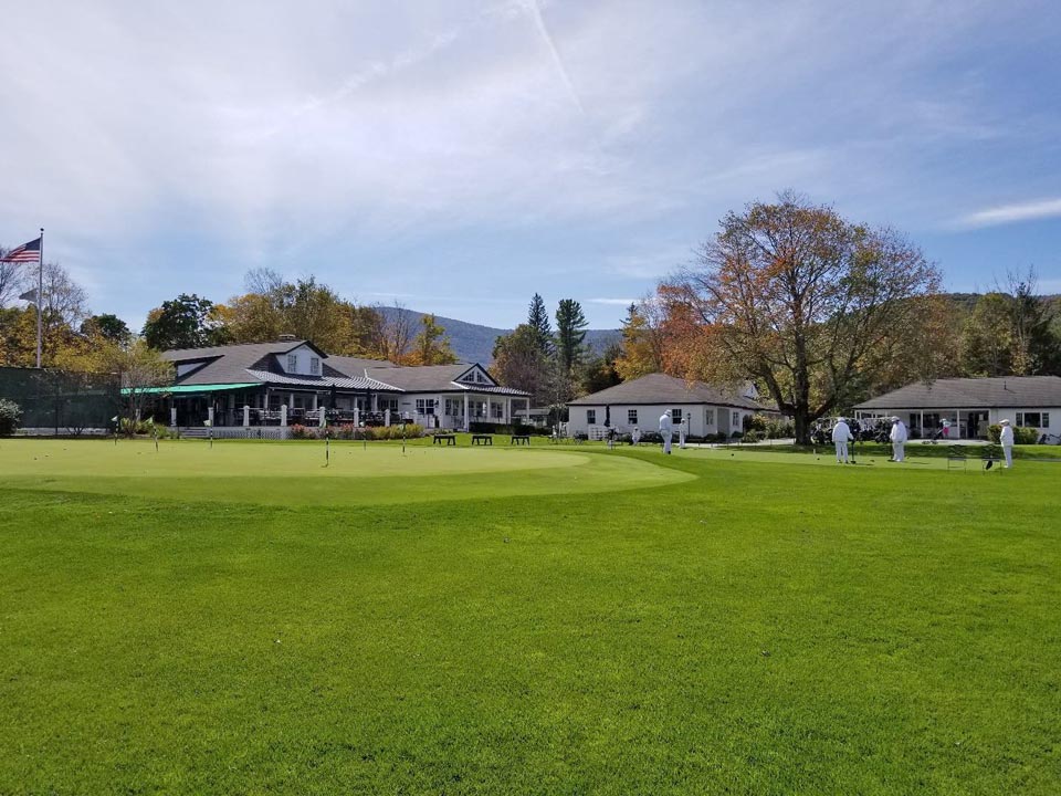
The game became so popular in Dorset that within a decade more spacious accommodations were needed, leading to the building of “Woodruff Hall”, which still serves as the clubhouse today. Over time
the course was expanded, first to 2,314 yards by 1900, and just over 3,000 in 1927. In 1999 a second nine was added with new holes split among both nines and the firm contention of the club is that golf has been continuously played on much the same piece of ground now for over 135 years, a year more than Foxburg (PA), two years longer than St. Andrews (NY), a full six years prior to golf coming to anywhere else in New England at The Country Club (Brookline, MA) in late 1892 and nine years before neighboring Equinox that opened in 1895.
It was with the love of this type of romantic historical tale that I set about to try to determine what actually happened.
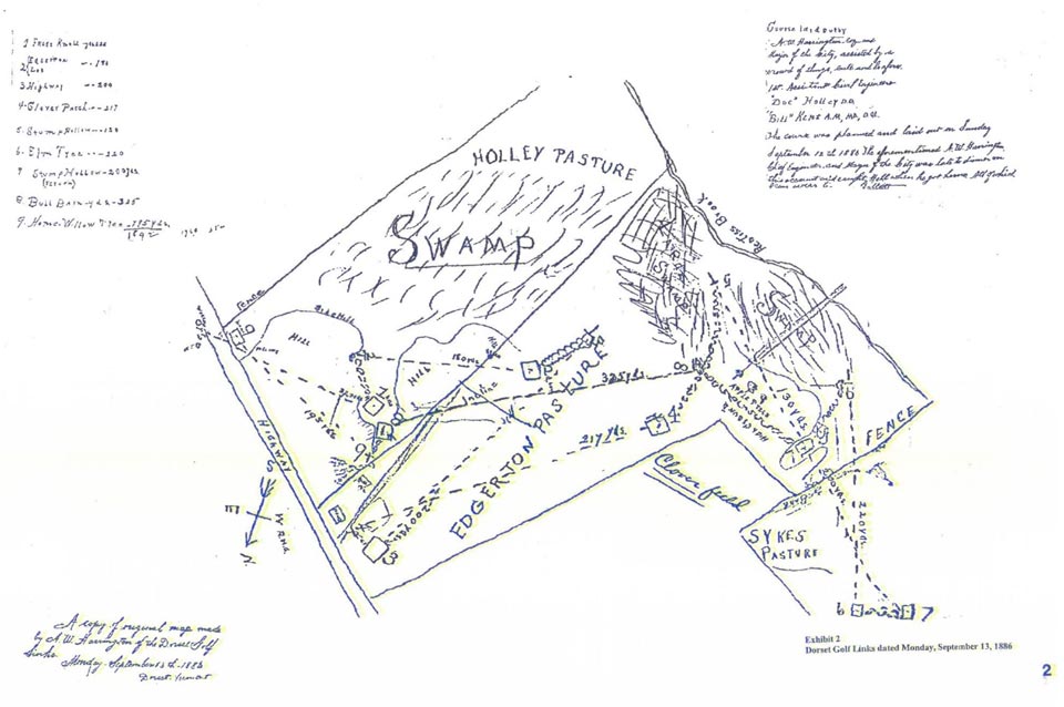
The Magical Map
On the evening of July 12, 1974 Dorset Field Club Historian and former President Gilbert G. Sykes addressed an audience of the “Dorset Historical Society” in the Vestry of the United Church of Dorset on the topic of “History of the Dorset Field Club, Organized September 12th, 1886”.
A year prior a book was published by one Jack Mahoney, titled “The Golf History of New England” that included the following passage; “Dorset does not have a comparable statement (i.e. sworn deposition) regarding its founding date. Formal yearly registers were not started until 1913 and the club seal was adopted five years later. However, the Vermont claim cannot be dismissed because of the circumstantial and hearsay evidence which supports it while club historian Gilbert Sykes searches for conclusive proof in the form of written records of the town’s land archives. Whether such real proof exists is debatable but pictorial evidence lends support to the claim and shows that golf was a permanent part of the Dorset scene well before the turn of the century.”
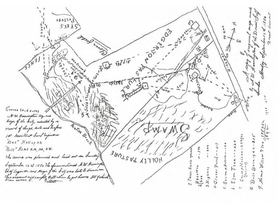
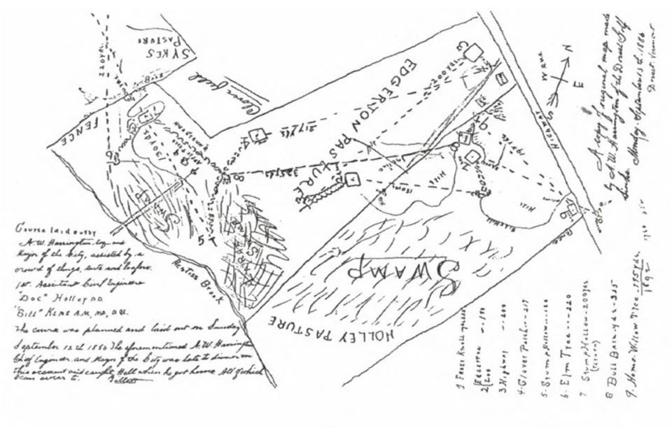
A year later, armed with what he apparently believed was documented proof, Mr. Sykes addressed his audience, as follows: “Another very important event occurred on September 12th of this year (1886) in the Dorset, Vermont community. A golf course was planned and laid out by “Arvin W. Harrington, Esq. and self-appointed mayor of the city, assisted by a crowd of thugs, touts, and loafers. The assistant civil engineers were ‘Doc’ Holley, D.D. and Bill Kent, A.M., MD, DQL.” This quote comes off a copy of the original map made by A. W. Harrington of the Dorset Golf Links on Monday, September 13, 1886 by Ransom H. Gillett, a copy of which each of you have…”
“A W. Harrington (B. 1859 – D. 1922) married Harriet Sheldon in Troy, New York in 1884…Harriet’s father came from Rupert and was a cousin of S. Frank Holley. In the very beginning only one golf club, known as a ‘cleek’ and owned by George Harrison was used by all, until Arvin bought the house later owned by the McGuffins, and set up his own club making shop to manufacture woods as well as hand-forged iron golf clubs, many of which are shown in the old photos I have here…”
“The original group that laid out the Dorset Golf Links was headed by Arvin, its first president. Others in this early group, who at first shared the one golf club were; Allen Bourne (editor’s note – actually Bourn), S. Frank Holley (B. 1858 D. 1932), Charles H. Keyes and George Lewis Prentiss, all of New York, New York; Richard M. Campbell, James C. Chapin, Ransom H. Gillett, Joe H. Harrington, George B. Harrison, Fred S. Hawley, Casper “Cap” Hulett, Edwin O. Lassell and O. P. Liscomb, all of Troy, New York; W. E. Kent and Henry S. Woodruff, both of Dorset, Vermont….It was not long before Captain Arv had the whole group well equipped with clubs and solid gutta percha balls, originally used here, as well as seeing that the boys used his bar properly.”
“They started on the first tee that was located on the east side of Route 30…From here the holes went over the pasture land of Edson L. Holley, the Edgerton farm, cutting across the Waldo Sykes farm and returning to the Holley property approximately 1,892 yards later…” Following the early tradition set in Scotland, the original golf course laid out in 1886 had names for each hole. (1) Frost Knoll, 225 yards; (2) Edgerton Lot, 180 yards; (3) Highway, 200 yards; (4) Clover Patch, 217 yards; (5) Stump Hollow, 130 yards; (6) Elm Tree, 220 yards; (7) Stump Hollow (return), 200 yards; (8) Bull Barn, 325 yards; (9) Home Willow Tree, 195 yards; for a total of 1,892 yards.”
The aforementioned map that Mr. Sykes distributed to his audience is fascinating and is pictured below. It is also confusing in a number of respects, not the least of which is the written notations are from three different positional orientations (in the same handwriting), possibly due to the various notations being written at different time periods. (NOTE: – We later learned that the three seemingly different notations were all originally in the same orientation and that others who wanted to highlight the golf course features moved them on subsequent copies to fit things tighter for their own individual purposes. An original copy appears in full at the end of this essay.) Nevertheless, a close examination provides an impressive amount of detailed information that does correspond to the existing golf course property. Everything from “Fences” to “Apple Trees” to “Clover Field”, to “Hill” to “Swamp” are noted as if perhaps the author was trying to convince future audiences of its authenticity. It is also reasonably to scale.
One notation in particular is intriguing, in that it somewhat self-consciously feels the need to identify itself as, “A copy of original map made by A. W. Harrington of the Dorset Golf Links. Monday, September 13th, 1886, Dorset, Vermont.” Why such a copy was deemed necessary, or what happened to the original, or when said copy was created, or why Mr. Harrington felt it important to draw such a detailed map the day after laying out said course is unclear.
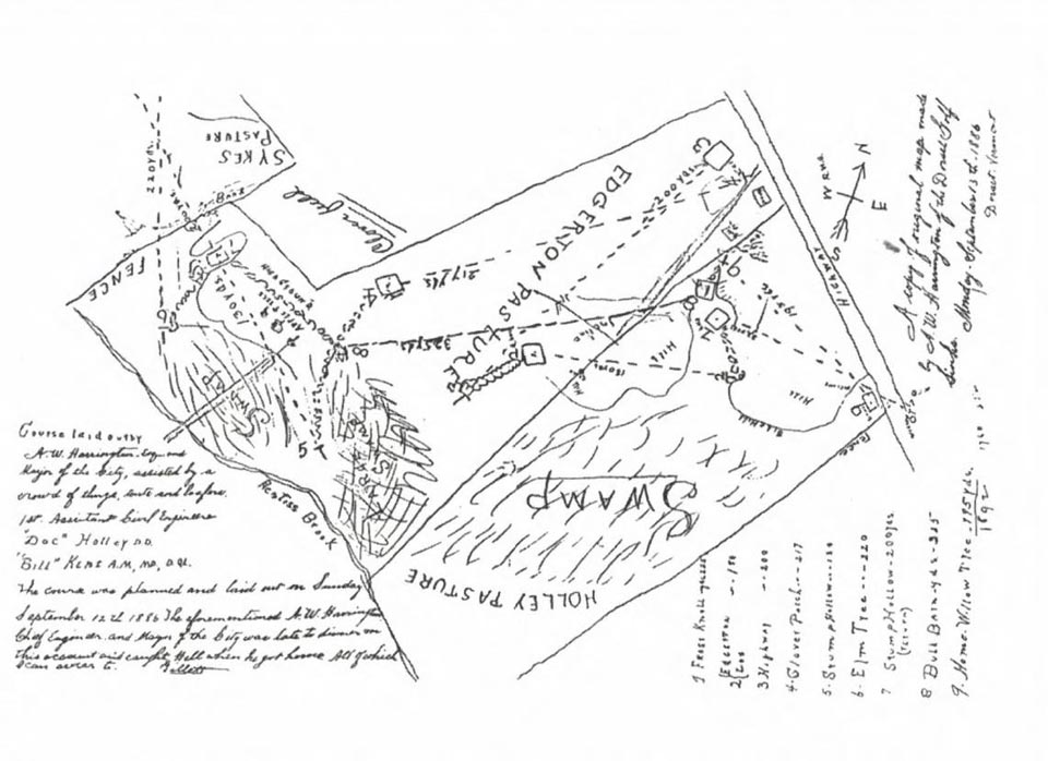
Another self-referential notation is the one Mr. Sykes partially quoted during his opening remarks, as if making sure course attribution to Messrs. Harrington, Holley, and Kent was properly noted, and continues in a bit of a joking manner, “The course was planned and laid out on Sunday, September 12th 1886. The aforementioned A.W. Harrington, Chief Engineer and Mayor of the City was late to dinner on this account and caught Hell when he got home, All of which I can swear to. -Gillett”, the signer believed to have been Dorset charter member Ransom H(ooker). Gillett, of Troy, New York.
From a golf standpoint, the course drawn on the map is notable from a number of aspects. Today’s clubhouse, known as “Woodruff Hall”, was built in conjunction with the opening of “Dorset Field Club” in 1896 and is located a hundred yards or more south of the first tee shown on the map which is located east of Route 30 as Mr. Sykes noted, evidence perhaps that this course preceded that date. Further, the greens of the 5th and 7th holes were shown in a presumably previously excavated area known as “Stump Hollow” (and “Stump Hollow (return)”), an area that still exists to this day. A number of other landmarks are accurate and the drawing is close to scale. A number of holes crossed over each other, perhaps not a big consideration with all of the players reportedly using a single club and presumably playing therefore as a large group. Still, it seems whenever this course was in use it didn’t last very long in this particular iteration.
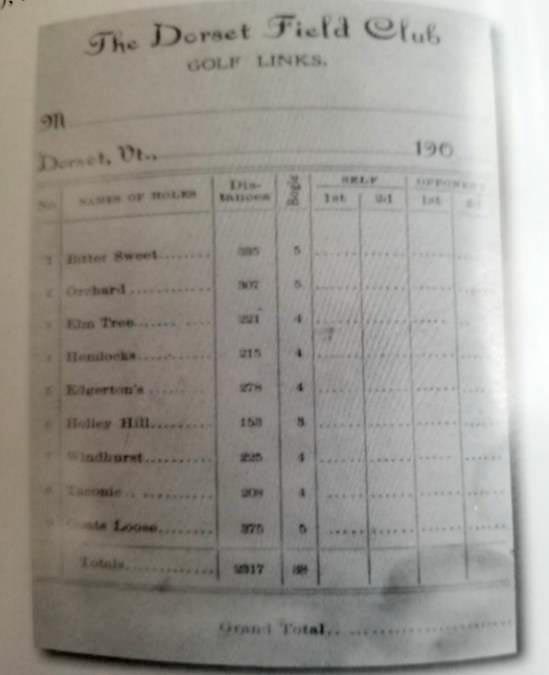
Mr. Sykes continued; “In the late 1890’s, as the course was changed and lengthened to 2,314 yards, the names for each hole were given as follows: (1) Bitter Sweet, 335 yards; (2) Orchard, 307 yards; (3) Elm Tree, 221 yards; (4) Hemlock, 215 yards; (5) Holley Hill, 153 yards; (6) Edgertons, 275 yards; (7) Windhurst, 225 yards; (8) Taconic, 208 yards; (9) Goats Loose, 375 yards. It should be remembered that approximately five different nine hole courses have been laid out over this original land plus adjacent properties acquired over the years as they became available. Even today, many old-type raised, square, dirt tees which were boxed in (and were replaced by longer and more elevated grass tees), outdated cross-bunkers and dangerous blind and circular greens still are to be seen but are no longer used. I have tried to show these various changes and approximate dates by pictures I have found and more recent ones I have taken.” (Note – The “five different nine golf courses” may be a loose interpretation as this author has traced the evolution of the course between the Gillett map and the course played by Mr. Sykes in 1974 and it seems the roughly 2,300-yard course laid out in the “late 1890’s” still existed into the mid-1920s when additional land was acquired and two holes were extended, creating a course of roughly 3,000 yards before 1930. Although some holes were lengthened and shortened and renumbered over time, the author believes that is the course that by and large still existed in 1974. In any case, none of the evolution occurring in the 1900’s is particularly pertinent to the question of year of origin.) Below is the first description of the course to be found in any of the golf publications of the time, this from the 1901 “Harper’s Golf Guide”. It should be noted that prior guides published in 1899 and 1900 did not included Dorset.
For more insight on early changes, here is the scorecard from the early 1900s that likely provided Mr. Sykes with his comparative information.
In 1925 the Dorset Field Club purchased the Waldo Sykes Farm (see previous map) and hired a new professional, Harry Rawlins (brother of first U.S. Open winner Horace Rawlins) who had been with the Equinox Golf Club in nearby Manchester Vermont since the late 1890s. By 1927 the course was expanded to a reported 3,007 yards with “two new holes”, likely with his assistance as he was credited with several designs. This 1937 scorecard signed by professional Charles Kinney (who succeeded Harry Rawlins when he passed away in 1934) shows the expanded course.
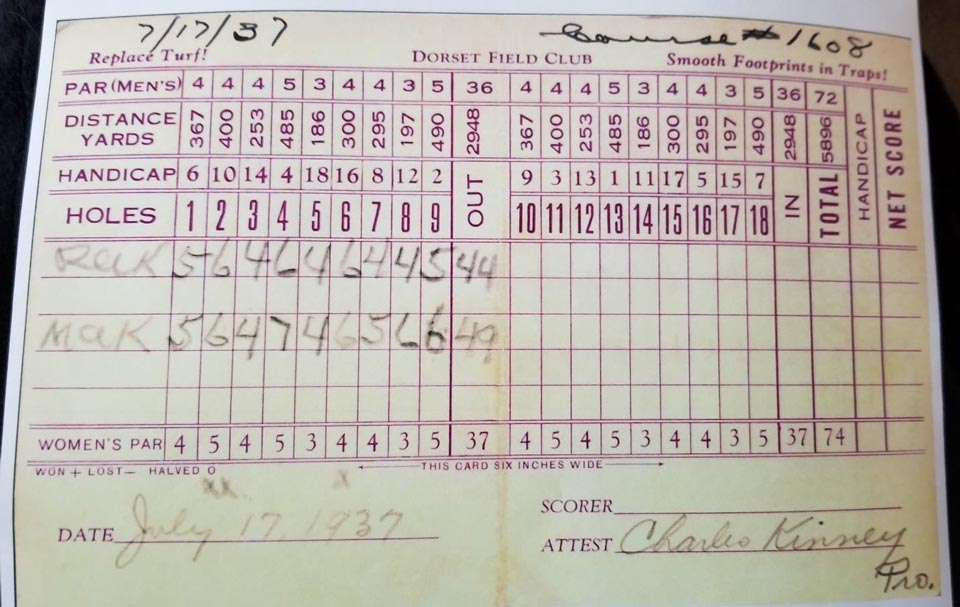
According to Gilbert Sykes, “One of Mr. Kinnie’s (sp) first jobs was to elevate the first green (today’s 10th), and shorten the 8th hole (today’s 2nd) to approximately 125 yards so as to relieve congestion around the 7th green (today’s 1st) in front of the brook. It was not completed until the fall of 1939.”
For those familiar with today’s course, or curious as to the progression, all of the 1937 holes still exist in some form on today’s course in the following sequence; 10, 11, 6 (shortened to a long par three), 7, 8, 9, 1, 2, 18 (shortened to a long par four when the original green became the practice green).
It should also be noted that one of the significant early changes was to the second hole, which originally ran from near today’s 11th tee to the excavation of “Stump Hollow” mentioned earlier. Sometime later the hole was turned into a dogleg left with an approach over a creek, (today’s 11th hole) and the 3rd became first a short par four shortened in time to a long par three from the top of the excavation to today’s 6th green.
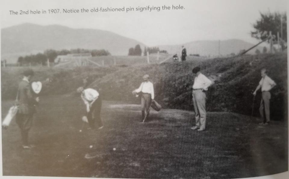
This 1907 photo shows the 2nd green still within the excavation before it was moved to today’s location behind the creek.
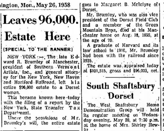
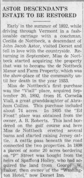
But, enough about today’s course and its evolution. It’s the course’s origins that we are here to examine. It should be noted that Gilbert Sykes was not the first club official to look for documented proof of the rumored vintage. Almost thirty years before Mr. Sykes spoke in front of the Dorset Historical Society, long-time club President Edward R. Brumley was engaged in his own research as noted in this 1945 article.
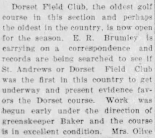
It should be noted at this juncture that research work at that time was not aided by the number of newspapers and other online resources that we are fortunate to have today. Work was done by sifting through old club records, photographs, and perhaps microfilm.
Subsequent research for a 1965 USGA Journal article, titled “Dorset’s Claim As Oldest Club” by John P. English yielded the following; “The last and best first-hand witness to Dorset’s claim was the late William G. Barrows, Sr., a descendant of Experience Barrow, who came to Dorset in the 1700s…Barrows, who died in 1964, was born in 1886, caddied at the club, knew most of the founders personally, and later moved through all the offices, including the presidency. He was a vigorous 76 when I talked with him three years ago and his position was as clear as a Vermonter can make it; “We know when our club was founded. It was founded in 1886.” His son, William G. Barrows, Jr., now secretary of the club, is equally certain from the testimony of old family friends and Dorset residents that golf started there in 1886, but his long search for confirming old records has so far been unsuccessful…”
“William G. Barrows, Sr., took me for a walk to show me where the first course had been built. We started on the east side of Route 30, on the property now belonging to Miss Cecelia de Nottbeck. From a long-abandoned first tee there, the early players shot across Route 30 to a green on the Edgerton farm, which, incidentally, is still the Edgerton farm. The outline of the old green is still visible. The course then cut across the Sykes farm and part of the Holley estate. Since the land was mostly pasture – much of it surrounding the course still is – the greens were fenced and the grass on the remainder was kept down by cows, an economy which had certain off-setting disadvantages, according to Mr. Barrows. This first course was used from the beginning to 1908, when revisions leading to the present course were initiated…”
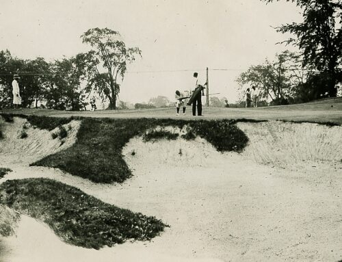
“Some of the most compelling evidence of the club’s real antiquity is conveyed in five magnificent and very old photographs…One of these is reproduced herewith and shows the late Ransom A. Gillett of Troy, N.Y., playing from the sixth tee of the original course, with other golfers putting in the background and some spectators watching from the bank of what must have been a small sand or gravel excavation. Incidentally, golfers today still drive across this old excavation when playing the third hole of the present course. Sadly, this picture bears no date and no legend except: “Dorset Golf Links.” The latter name carries some significance, however, because the club was known as “Dorset Golf Links” from its founding until it moved into Woodruff Hall, so the pictures must have been taken before 1896, a speculation which is at least not contradicted by the costumes, the nature of the tee and the old sand bucket.”
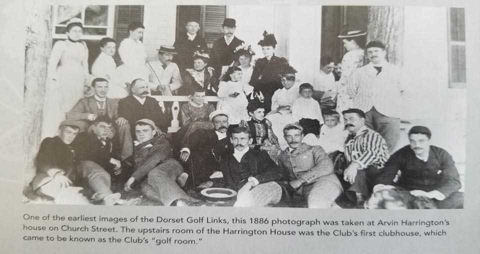
“A second photograph of a group of capped and mustachioed men and full-skirted women on and around a hay wagon bears the legend: “1886 – Hayride – Dorset Golf Links.” The late Mr. Barrows told me that this was in fact a picture of a group of summer residents engaging in a regular social function of the time and that it was taken on the fourth fairway of the original course…A third photograph shows a group of men and women, again in costumes typical of the 1880’s grouped on the lawn of the Harrington residence, and the legend reads; “1886 – First Clubhouse of the Dorset Field Club Was in This House.” The remaining two photographs show the present clubhouse in its earliest state and a group of golfers. The former bears the title, “Woodruff Hall – Built 1896”, and the latter bears no legend at all, although the faces and the mountain background made it clearly Dorset members assembled on the fourth fairway.”
Careful readers might note that the notation on the photo of golfers assembled at the Harrington residence almost certainly had to be written sometime after the fact as it referred to it as the “First” clubhouse. It is unknown when the other captions were written, or by whom.
Mr. English concluded, “I cannot prove any case with documents, but I have no doubt, personally, in view of the character of the witnesses and the very nature of the place, that the Dorset Field Club deserves to be ranked with Foxburg and St. Andrew’s as one of the three oldest clubs and one of the two oldest courses in the United States with continuous existence.”
For reference, here are photographs of four of the photos mentioned above reprinted in Daniel Beck’s 2016 “Dorset Field Club: 1886 – 2016, A Pictorial History”.
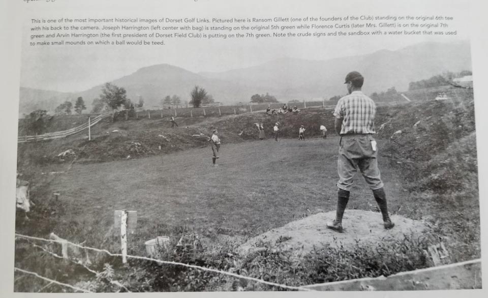
It is worth noting that the first and third pictures were likely taken the same day, as evidenced by the clothing worn by the golfers in the group, most notably one Ransom H. Gillett, pictured on the photo just above standing third from the left wearing the same golf togs as above where his back is to the camera standing on what is referred to as the “sixth tee” of the original course. The Harrington brothers who appear in both photos are also identically dressed. It also seems that at the time of this photo there were plenty of golf clubs (and golf bags) to go around.
Daniel Beck’s centennial history book continues the tale; “…the map of the original course (with Ransom Gillette’s (sp) 1886 notation) and the original constitution and bylaws (dated 1896) were discovered in 1974. But as fate would have it, those documents were destroyed when being copied for the Club’s Centennial Celebration in 1986. Still, as a result of these documents and an additional investigation, Ross Goodner built upon the 1965 Golf Journal article by writing (in Golf Digest in August 1987), “I think it’s possible to go one step further and accept that Dorset Golf has been in existence since 1886, Foxburg since 1887, and St. Andrew’s since 1888”. Recently, Bob Labbance wrote a 2007 article in “The Bulletin (published by the Golf Collector’s Society) titled “What is the Oldest Continually Operated Golf Club in America?” in which he explains, rightfully, that it is impossible to prove the provenance of the map because the original copy was lost. After retracing and updating the research done previously by John English, Mr. Labbance leaves the final decision to the reader; “You make the call.”
From the “Bausch Collection” at MyPhillyGolf.com, a view of the same excavation area that seemingly served as multiple greens on various iterations of the early golf course.
Today’s golfers still play over the depression on today’s long par three 6th hole that also was a short par four from a tee closer to today’s 11th green when the 2nd green was relocated from the hollow to an area left of here just behind a creek in 1927.
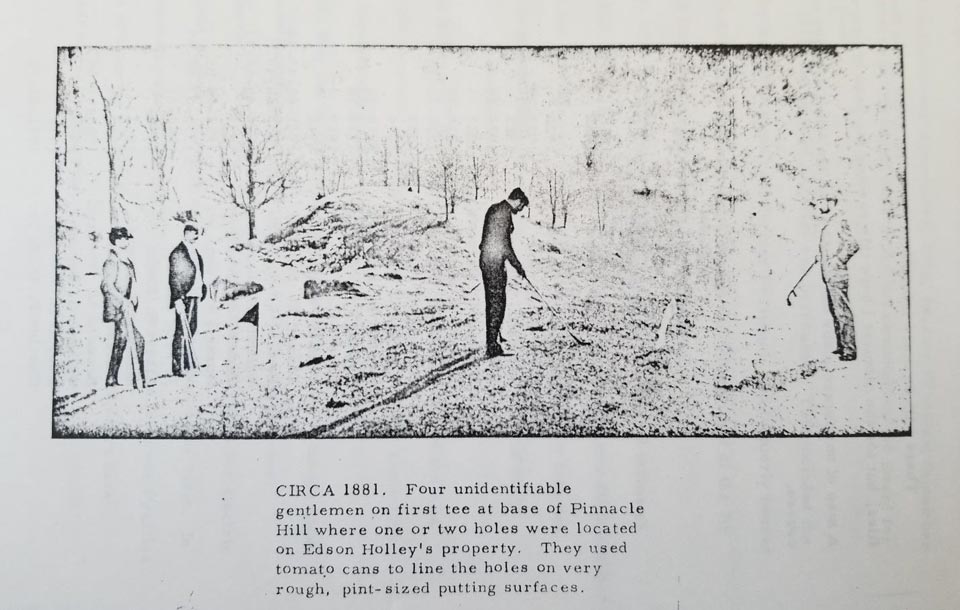
Before we move on to examine the evidence for Dorset mentioned in various local news accounts, lets further revisit some of what Gilbert Sykes presented in 1974. “These Dorset Golf Links have long been believed to be the oldest 9-hole golf course in the United States. There are indications that there may have even been an earlier golf course laid out around our Pinnacle Hill as early as 1881, but we have only one picture with 4 unidentifiable gentlemen on a tee playing in this area on the northwest side of the pinnacle, which is today so heavily endowed with trees and underbrush that it is quite impossible to confirm this theory…Going back a little, when Woodruff Hall was completed in 1896, the name was changed from the Dorset Golf Links to the Dorset Field Club. According to our original club seal, the Dorset Field Club incorporated in 1918, even though it had been well established and organized 32 years earlier, per map evidence presented here today to each of you, and with grateful thanks to Messrs. Harrington and Gillett for thinking of it.”
I was able to procure a copy of Mr. Sykes’ remarks for the very helpful staff at the USGA Library & Museum in Far Hills, NJ, and the following photograph mentioned above was attached.
I instantly recognized it from a photograph I had taken in the clubhouse of the Dorset Field Club a few years back, which was hanging on the wall near the men’s locker room, reproduced below.
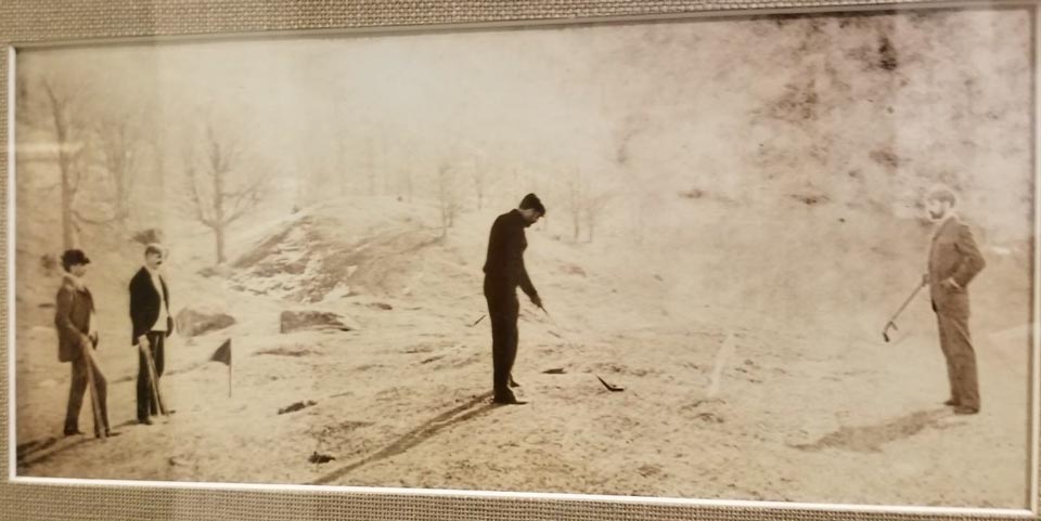
A few years back golf writer and historian Anthony Pioppi mentioned to me that this photograph was not from Dorset at all, but from Woodstock (VT) Golf Club, founded in 1895. A summer 1954 article in “Vermont Life” titled, “Green Mountain – A Review of Vermont’s 35 fine courses” lends credence as it mentions that the photograph is of one Arthur Wilder, who ran the Woodstock Inn from 1897 to 1935.
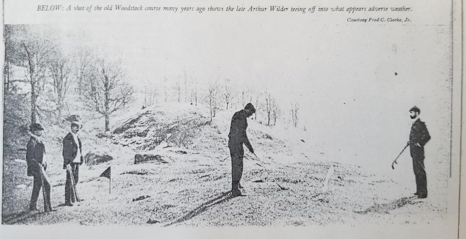
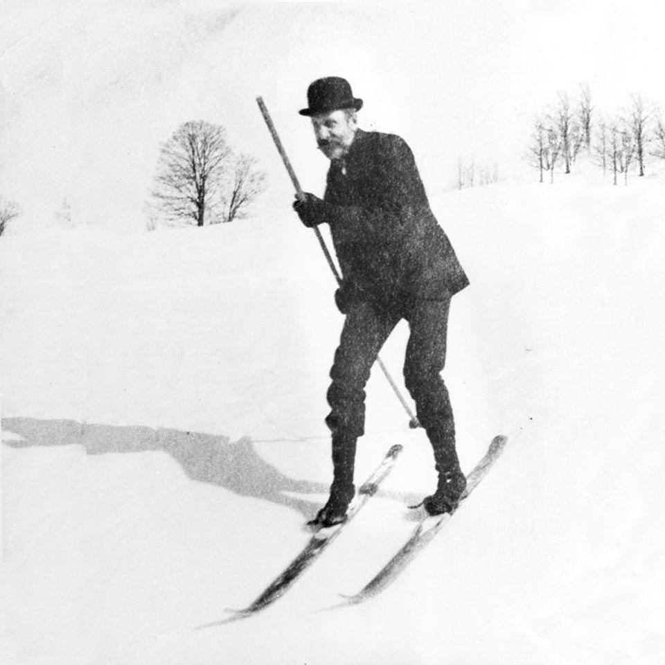
The aforementioned Arthur Wilder enjoying the Woodstock slopes
The Missing Media
As mentioned, one of the great advantages modern researchers have is the ability to search online resources such as newspapers that simply weren’t available to those in the past. Two publications in particular regularly covered social and sporting activities in Dorset and I’ve used both extensively in the following section; The Manchester (VT) Journal and the Troy (NY) Daily Times. The former is from the lovely resort town that is a mere six miles south of Dorset along Route 30, and the latter city was the home of many of the regulars who “summered” in Dorset. Quite a few other Vermont newspapers reported on events in the resort area, as well, and all are noted in the bibliography.
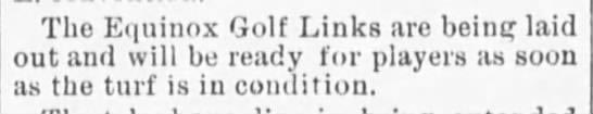
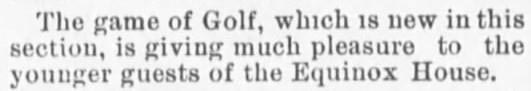
The first mention of golf in the area I’ve been able to discover comes from the following articles in the “Bennington Banner” in July of 1895 but not about Dorset but instead Equinox in Manchester.
And again in 1896 and 1897, as follows;
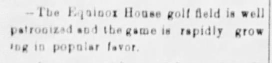
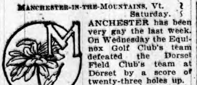
Numerous reports in the following years tracked golf at Equinox, and by 1898 various mentions began to detail the building of a new golf course at neighboring Ekwanok.
Meanwhile, a report in June of 1896 is the first inkling of formalization of social and sporting activities happening in Dorset.
However, from the outset it seems the thinking was more related to indoor activities in the form of a “casino” with outdoor sporting activities consisting of tennis. Not a single mention of golf was included.
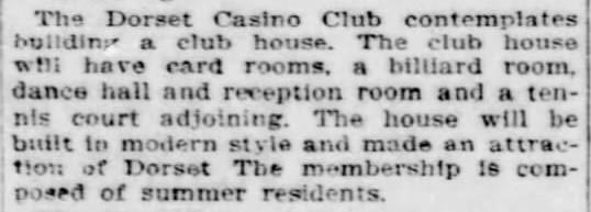
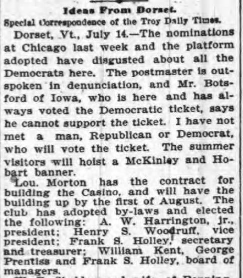
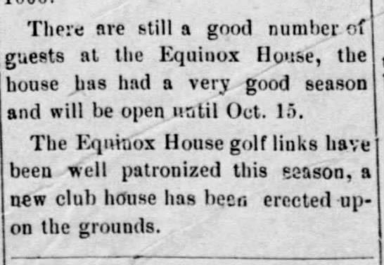
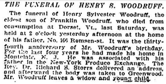
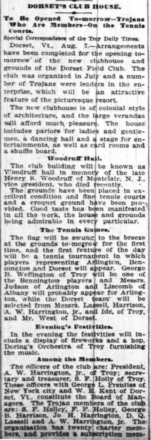
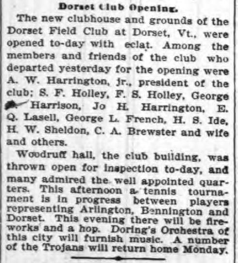
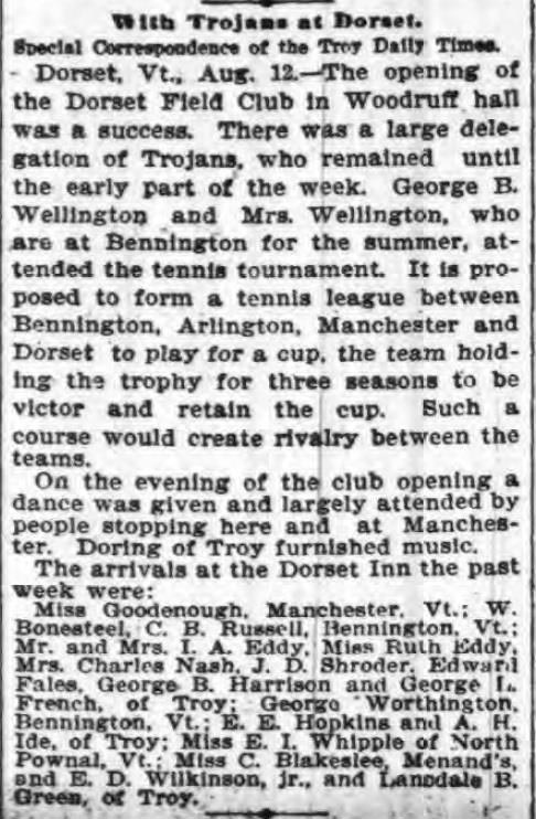
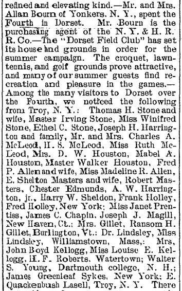
Sadly, during construction Henry S. Woodruff of Montclair, NJ, one of the founders and funders of the new clubhouse passed away and the building was renamed in his honor. The following articles extensively describe the new club’s opening, but yet again, no mention of golf.
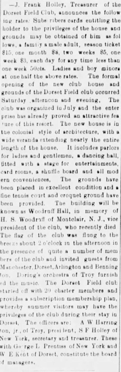
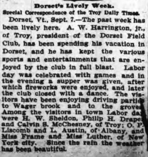
Finally, in the summer of 1898 we see the first mention of golf at Dorset from a series of articles mentioning inter-club play between Equinox and several regional teams, including Dorset.
Finally, in July of 1898 we see the first mention in the press of “golf grounds” at Dorset.
Still, it is difficult to imagine that a group of golfers who had ostensibly been playing the game at their own course for sixteen years at this point and eight years before anyone else in New England (1892 at The Country Club) would have been beaten this badly but it’s certainly possible.
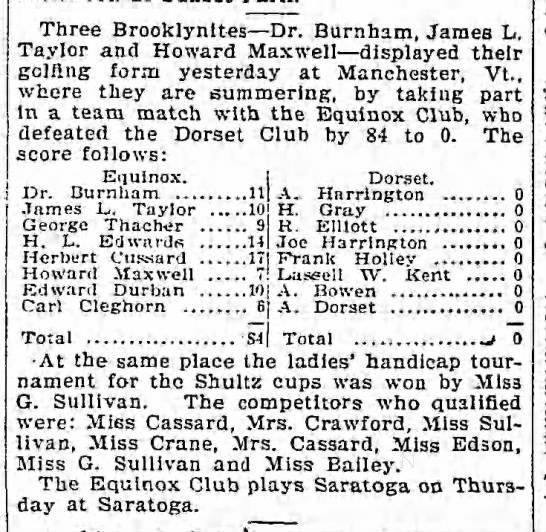
As mentioned previously, national golf publications at the time such as “The Links Book”, and/or “Official Golf Guide” do not mention Dorset as having a golf course. In the state of Vermont, the following courses are named with brief descriptions; Bellow’s Falls, Equinox, Mount Anthony, Rutland, Walpole, Waubanakee, Woodstock, and Ekwanok. This might be explainable if Dorset was tucked in some rural, little-known outpost of the state but is less understandable in one of the popular “summering’ centers of New England and just a few miles up the road from Equinox and Ekwanok.
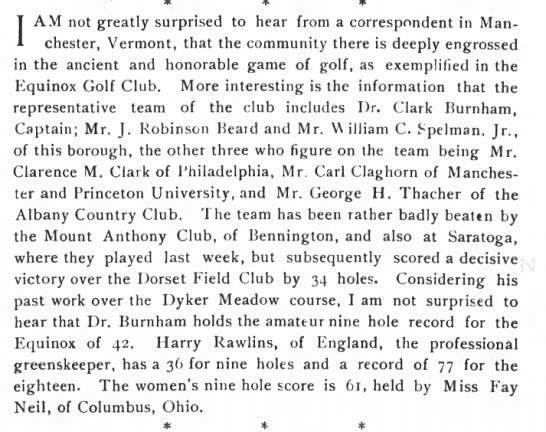
In fact, the 1902 “USGA Journal” published an article titled “Golf in Vermont” by John Morton Marbury, a Manchester native who was part of the preeminent “Orvis” family who owned the Equinox hotel. It includes the following caption describing the first original Equinox course.
The article continues with a brief description of each and includes the following regarding Dorset.
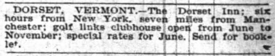
The “Dorset Inn” was founded in 1796 and to this day continues to be a popular hostelry located right on the corner next to the Dorset Field Club. The first mention of golf in any of their advertisements comes from this May, 1899 “New York Times” snippet.
Two years later in June of 1901 the golf course at Dorset Field Club was mentioned in the “St. Albans (VT) Daily Messenger” but the description hardly sounds like one that would have been fifteen mature years old at that time.
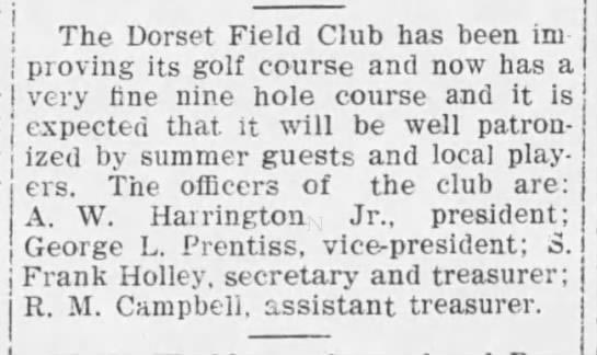
In fact, the author has not been able to find a single claim by the originators of Dorset Field Club that their golf course was built in 1886, much less the first course in the United States. None of the early accounts mention that date and it wasn’t until 1946 that an 1886 origin was claimed, in the “Manchester Journal” likely in conjunction with whatever materials President Brumley discovered that led him to that conclusion. It is not known what that particular evidence consisted of or whether it was the aforementioned A.W. Harrington map ostensibly copied by Ransom H. Gillett sometime post facto.
Just previous to then, in the summer of 1945, a syndicated snippet ran in newspapers nationally that claimed a different date of origin, again likely as an outgrowth of President Brumley’s ongoing research and reported correspondence, this particular one clipped from the Clarksville (TN) “Leaf Chronicle”.
The Marvelous Men of Troy, aka The Trojan “Horses”
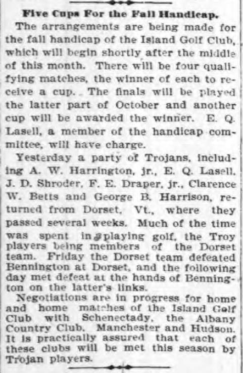
If the men who built the club and golf course at Dorset didn’t play there until the late 1890s, as the contemporaneous media accounts would suggest, it’s a fair question to consider where they might have first been exposed to the game. The following “Troy Daily Times” articles from 1900 mentioning familiar names like Harrington, Gillette, Cluett, and Harrison provide a clue. Were these the same “thugs, touts, and loafers” mentioned on the golf course map?
The term “touts and loafers” is interesting in this context. Doing a search on the term it referred to essentially lazy, shiftless men who often populated horse racing tracks or other gambling venues like casinos, making their livings by selling “tips” to the unwary, or otherwise living non-productive lives. The first printed versions of the term I found were from the 1860s and the term seems to have become anachronistic and no longer used by the 1960s.
Perhaps the best place to start is at the end. Arvin Harrington passed away of a heart attack in 1922 at the age of 63 (he would have been 27 if the Dorset course was created in September 1886), and given his social prominence, his lengthy, detailed obituary in the “Troy Daily Times” included this portion;
Arvin W. Harrington was a very prominent Trojan who was successful and well-like and admired, and a success at his insurance business, various athletic clubs, military affiliation, and assorted civic endeavors. Despite the map referring to him as “ESQ”, he was neither a lawyer nor a “civil engineer”, nor the “Mayor” of Dorset (or Troy).
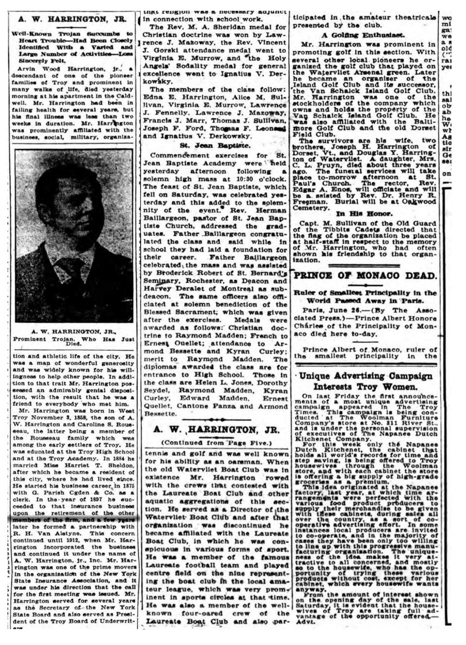
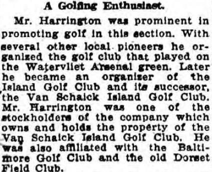
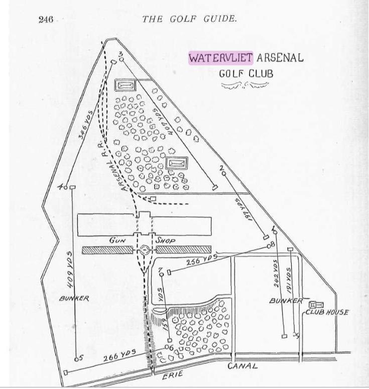
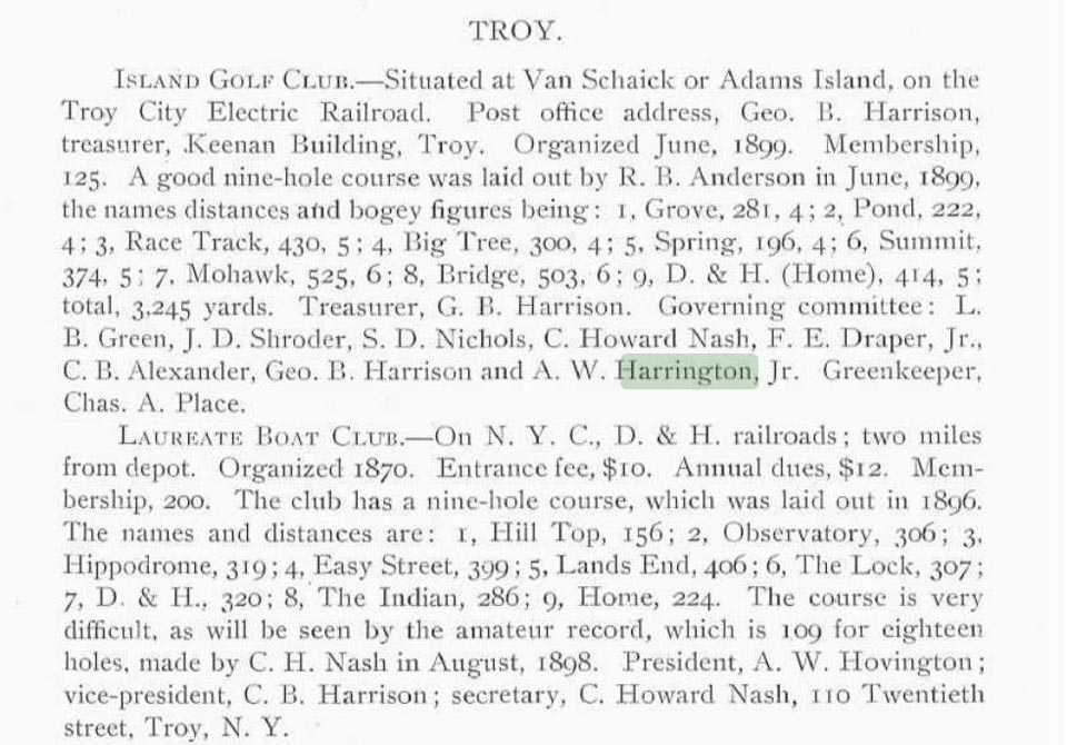
As mentioned in his obituary, by the mid 1890’s Harrington was deeply involved in the activities of early golf courses in and around the Troy and Albany (NY) areas with his close friend George B. Harrison. These included the golf course at the Watervliet Arsenal (the first military golf course in the United States), the short-lived golf course at the Laureate Boat Club, the Island Golf Club (today’s Van Schaick Island Golf Club), and the attempted Brookside Country Club in Albany, which failed because of price negotiations for the land couldn’t be settled.
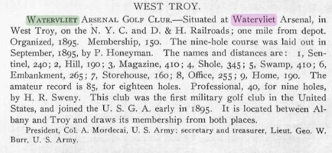
It seems most likely from available evidence that Harrington’s introduction to golf occurred at the Watervliet Arsenal golf course sometime after its creation in 1895, described as follows in the 1899 Harpers Golf Guide.
Harrington and Harrison caught the golf bug, and before the end of the century seemingly launched other golf ventures in the New York Capital region. The following is from the Harper’s Golf Guide of 1900, although both men’s names were misspelled for the latter club;
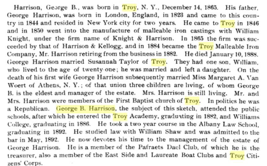
George B. Harrison was seemingly a close friend of Harrington’s by the mid-1890s and another charter member of Dorset Field Club. The following biography comes from the 1901 publication, “Landmarks of Rensselaer County”. It should be noted that Harrison would have been 20 years old in September of 1886, as was Dorset charter member Casper “Cap” Hulett, while Harrington was 27:
But what of the other men mentioned as Harrington’s co-designers of Dorset Field Club, as noted as follows on the course map notated and signed by “Gillett”?
“Course laid out by A. W. Harrington Esq. and Mayor of the City; assisted by a crowd of thugs, touts and loafers, 1st Assistant Civil Engineers “Doc” Holley D.D.[,] “Bill” Kent A.M, MD., D. QL. The course was laid out on Sunday September 12th 1886[.] The aforementioned A.W. Harrington, Chief Engineer and Mayor of the City was late to dinner on this account and caught Hell when he got home. All of which I can swear to. – Gillett”
It is curious to note that the suffix abbreviations found with each name seem to be more collegial attempts at inside humor than professional titles. Certainly the obituaries for each of the two men (much like Harrington’s) bear no indication of any of the professional statuses designated by the abbreviations. Once again it is noteworthy that Holley would have been 28 in September of 1886, while Kent, like Harrison and Hulett was 21;
Finally, and most relevantly, what of Ransom Hooker Gillett, seemingly the author of the golf course map and related annotations that seemingly offer the authenticity of the 1886 vintage claim? First, I think it’s very important to note that virtually all of these men were not only civic, social, athletic, and military stalwarts in their respective Troy and Dorset communities, but they also were some of the very earliest pioneers of introducing and popularizing the game of golf in those areas and for that deserve considerable recognition.
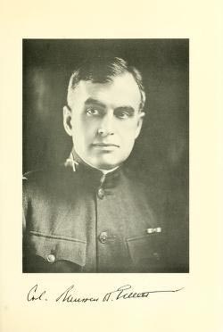
Of them, it was Ransom Gillett who became the best known, serving valorously in the military, distinctively as a lawyer and a politician, and brilliantly as a community leader. Upon his sudden death in 1941, the “Berkshire (MA) Eagle” presented the following account of his life:
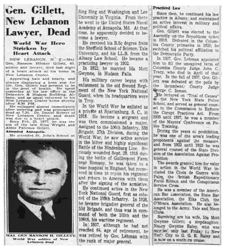
Despite his social prominence, at no time in his 63 years was it recorded that he claimed golf in America started at Dorset Field Club in 1886. Relatedly, at no time during his life was it ever recorded that he drew, or copied, or otherwise reproduced a copy of what was ostensibly a map drawn by Arvin Harrington of the original golf course at Dorset Field Club.
Moreover, it would have likely been impossible for Major General Ransom H. Gillett to have been a charter member of the golf course at Dorset Field Club if it had indeed been first created in 1886 as he would have only been a nine-year-old boy!
Now, it is true that Gillett later was a member at Dorset and played golf there but it wasn’t until sometime in the later 1890s that the first evidence of that fact was recorded. He was also a good friend of Arvin Harrington’s and was even a pallbearer at his funeral in 1922. Retrospectively, it seems somewhat incredulous looking back at the early pictures of Gillett playing golf at Dorset above that no one seemingly ever noticed that he was a much younger man at the time than the others in the photograph, likely in his late teens or early 20s. Whether he later created the map in question sometime posthumous to Harrington’s passing, or perhaps later in his years in an attempt to recollect early events later verbally related to him, perhaps even inadvertently missing the origin date by a decade or so (even though the days of the week mentioned correlate to 1886, not 1896), it seems incongruous to the fact that neither Gillett or anyone else ever claimed Dorset Field Club’s golf course was created in 1886 until four years after his death, in 1945, almost sixty years after the fact.
Yet despite all of that, by 1954 the story had become much more detailed and unfortunately, not much detail about the claims has been yet able to be sourced by this author. It hasn’t helped that despite the club clearly being formed for social and athletic purposes by at least 1896, the club itself never drew up papers of incorporation until 1918, as follow;
In 1954 a publication of the local hostelry the “Barrows House” in their “Barrows House Bugle” published the following detailed account of golf history in Dorset that was reproduced in a Manchester newspaper. By that time the story had taken on more detail, again without much in the way of supporting evidence:
Perhaps not coincidentally, just over a year later former Dorset Field Club President Edward R. Brumley who researched the club’s origins in the mid 1940’s passed away. It is not known what the source of his origin claims entailed, as the club believes the course map drawn by Gillett that seems the strongest basis of proof was not found until 1974.
A few years after Mr. Brumley’s death it was reported that he left his entire estate to a Dorset woman he evidently held in close regard. Clearly, he seemingly was in love with Dorset and its residents.
Muddled Meanderings and Meaningful Maps
The amount of detail on the golf course map and the placement of the golf course in an area well north of the clubhouse that was eventually opened in 1896 speak to me of a certain authenticity that goes beyond coincidence. Certainly, the romantic in me would love to be able to prove the claim that a bunch of young, motivated summering residents with a single club and some golf balls laid out a course in 1886 in a most informal manner, continued to play periodically in a similar vein until someone thought they should formalize things which they eventually did in the late 1890s.
Other than the map, there was not a single shred of evidence of that, however.
Instead, at first blush what seemed likely to me is that in a sincere attempt to determine the origins of what is clearly a very old golf course, Mr. Brumley, perhaps with some assistance from Ransom Gillett before his death, tried to piece together the evidentiary fragments of history and memories into a cohesive whole. Certainly Mr. Harrington had been coming to Dorset since at least 1882 and in 1884 he married a local girl and the club may have come across some photographs that were either dated at the time they were taken, or perhaps retrospectively, and possibly made some assumptions that golf was indeed among the sports that were played when fellow summering Troy residents gathered at the popular Mr. Harrington’s house. Indeed, the oldest photographs I’ve seen show evidence of sporting activities but not of golf.
I then shared this essay with the Dorset Field Club prior to publication here as I believed it was the right, fair, and just thing to do and because I wanted this piece to benefit from any other information or factual evidence I may have missed in my research. The club certainly has a right to be very proud of their heritage and place in Vermont and national golf history over these past 125 or more years and my only intention in writing this article was to try to collect, interpret, and relate the historical facts wherever the story led.
The Club Historian, Kevin O’Toole very graciously replied to my outreach multiple times and his responses led me to dig deeper. He suggested two possible explanations for what appear to be gaps in the story; first, that because the club owned none of the land on which they were playing golf until the first parcel was acquired in the 1920s that golf was something of a separate activity from what generally took place on the grounds of the Field Club. Indeed, the “map” seems to indicate that the original golf course was located well north of the clubhouse, (the aforementioned Woodruff Hall) and other Field Club activities. Mr. O’Toole provided me with a “Certificate of Title” that describes all of the various property acquisitions that make up today’s holdings. He also sent along a copy of the club’s bylaws from the year 1900 which does not include a mention of golf although we now also know for certain that they were playing golf at that time.
This July 1900 article from the Granville (VT) Sentinel seemingly alludes to this seeming division of activities between the Field Club and golf. While not conclusive it is one more piece of evidence that golf was not totally “folded in” at that time, possibly due to the lack of ownership of the lands in question and the inherent risk that golf might still fall out of favor with the landowners, with subsequent refusal of permission hanging over their heads.
Secondly, Mr. O’Toole suggested that because the map was simply signed “Gillett” then perhaps it wasn’t Ransom H. Gillett after all given his young age but instead possibly a father or grandfather. At first this too seemed like a possible dead end as I quickly learned that his grandfather (and namesake) passed away in 1876. Gillett’s father Silas Wright Gillett then passed away in 1878 at age 47 (surviving his own father by only two years) which must have been rather tragic as the young Ransom was only a year old. His mother, Abigail (Abbie) Wood Gillett passed in 1907 and Gillett himself only had one child, an adopted girl in 1910. Indeed, the 1880 census shows the widowed Mrs. Gillett (and her 3-year old son Ransom) living with her father in New Lebanon, NY.
As I began to investigate further I came to the realization that even though Gillett was only 9 in 1886, I don’t think that precludes Ransom Gillett as either an eyewitness to events or as the subsequent “copying” author of that map. On page 10 of the Beck history book there is a photograph that shows Gillett’s mother seated at the home of Spafford Frank Holley with some younger children in what looks like almost a family scene. The picture mentions that “the home had been rented to them for several summers”.
A few things seem to me self-evident. Given the family situation vacationing with other Trojans in this “cottage community”, there is no question that young orphaned Gillett would have known the Harrington’s, Holley’s, etc., and given the age difference in 1886 (Arvin was 28, Gillett 9) it is likely that he may have viewed them as almost step-fathers, or perhaps uncles and it is likely they would have taken an interest in the boy’s welfare, as well. At some point after Harrington’s death, he perhaps saw a need to create (or copy?) a drawing done by Harrington, seemingly for posterity. Might he have been there that day watching these men create a golf course? It certainly doesn’t seem beyond the pale.
Gillett was quite the accomplished man who served in state government in legislature and on the bench, as well as a decorated WWI hero with an illustrious military career afterward heading the NY State National Guard as a Major General. I began to realize that it could provide a great deal of credibility to the origin story of Dorset Field Club to find other examples of his handwriting to compare against the map. As mentioned, the map is fairly unique in the placement of golf holes and native features and therefore seems incongruous with something someone would create fraudulently without knowing the original golf course existed well away from Woodruff Hall. It’s a shame the Gillett’s copy of the original Harrington map was lost because it would have been interesting to see if it had been created on “copy paper”, or if anything else about it provided clues to its origin and possible dating.
Nevertheless, I now believe we can prove that Ransom H. Gillett as a young boy was in Dorset with his mother staying with the Holley’s. Here’s the picture from the Beck history book.
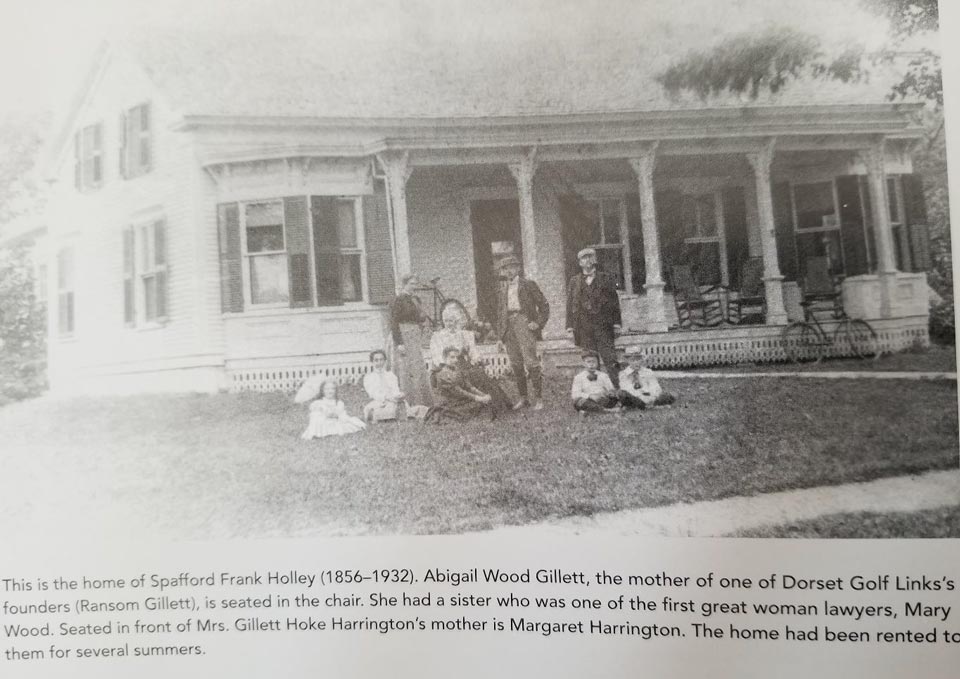
After careful examination, I believe the caption is mistaken. The woman seated in the chair (with white hair) seems to be too old to be the mother of a 9-year-old and instead I believe Abbie Gillett is the woman seated on the grass directly in front of her. Young Ransom and his thick shock of dark hair is I believe the boy seated on the lawn on the left next to another youngster.
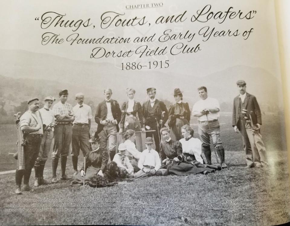
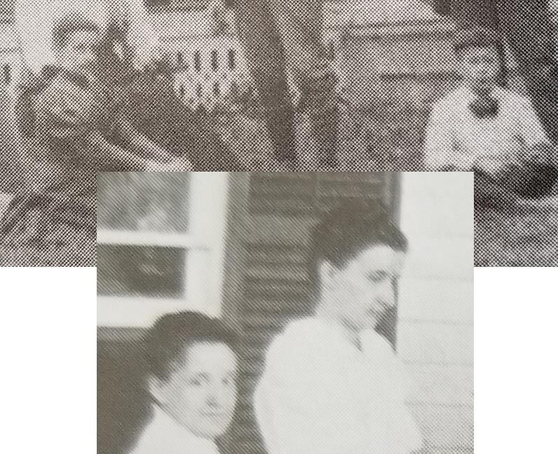
Another photo from the book that looks to be from the same time frame shows a large group of people gathered at the home of Arvin Harrington. The Harrington brothers are in the striped coats on the right, possibly wearing some type of club jackets.

With closer examination, it appears that both photos show young Ransom Gillett with his mother as well as a motley crew of assorted “thugs, touts, and loafers”. I blew up each photograph and zoomed in.
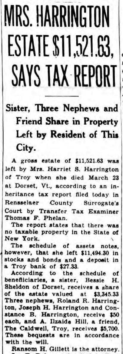
We know that Gillett was very close to the Harrington’s and was a pall bearer at both brother’s funerals in 1922. Now we also know that the orphaned Gillett did indeed spend summers as a young boy in Dorset. However, years later in 1940 when Harrington’s wife Harriett passed away we see that Ransom H. Gillett was the lawyer who took charge of executing her will and dispersing of the items in the Harrington estate. Might this have been when he came upon the original map, perhaps worse for wear and threadbare over the previous five plus decades and determined to copy it for posterity?
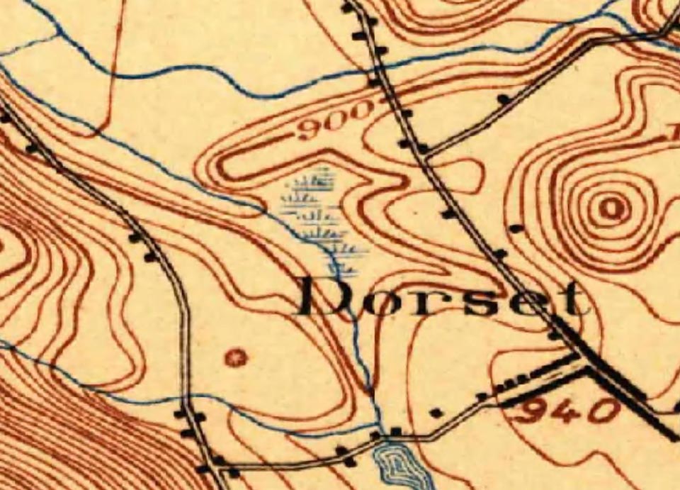
At this juncture, it’s worth looking at the map again. As mentioned, it does line up with some natural and man-made features still evident today and compared against a 1897 topographical map (larger surface area shown) there is congruity. Mr. Sykes comments in 1974 mentioned how the first greenkeeper Grant Matson, “who superbly drained the swamps.…” came to us “around 1904” and was “with us until Labor Day of 1937…”
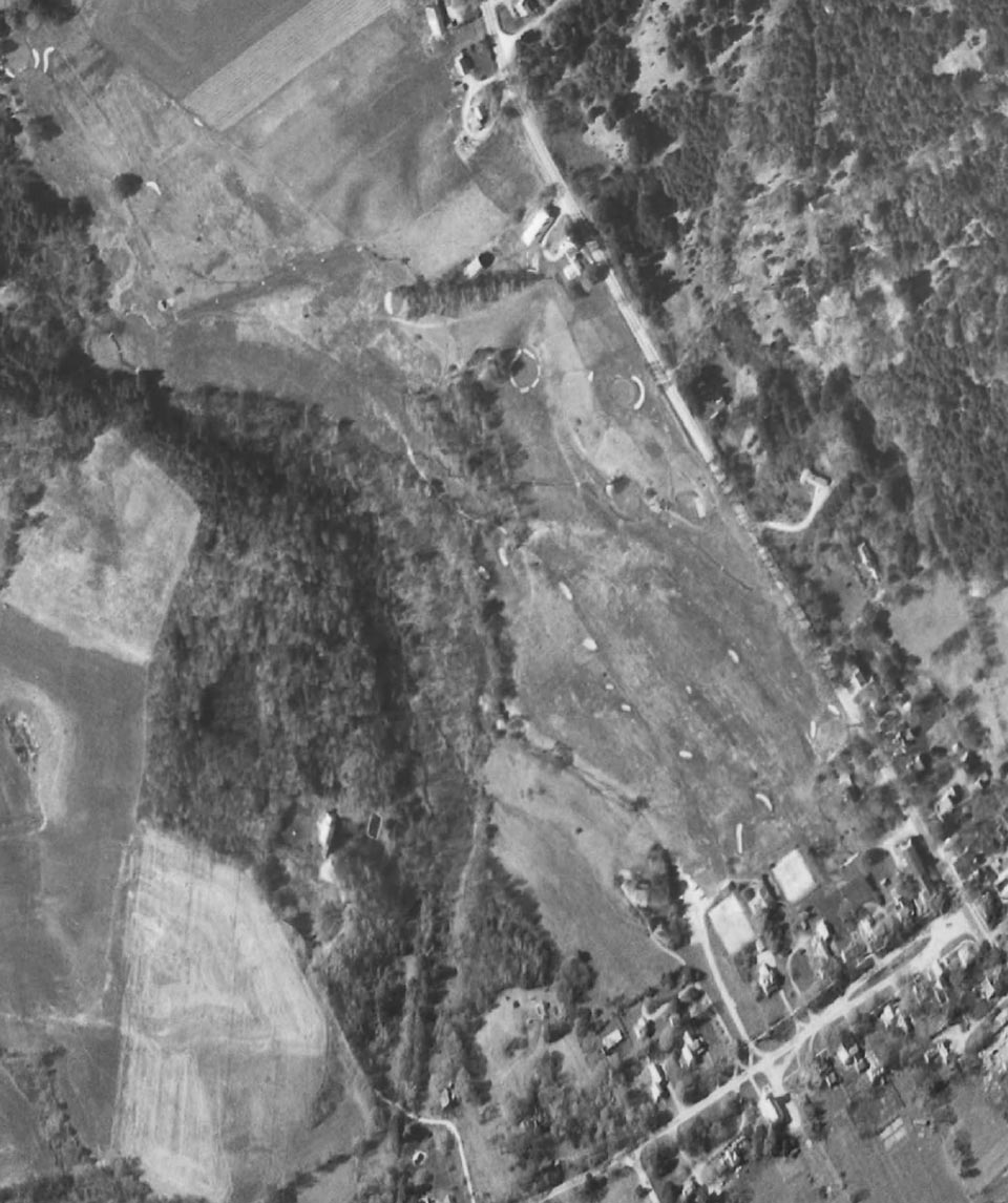
This 1962 aerial photograph shows the 9-hole golf course that existed at that time and all of the holes still exist today.
It is important to note a few things on the drawn map. First, my best digital copy of the map is missing the 6th green/7th tee locations but they do exist on the Gillett document and are included in the Beck history book. Second, even though I’ve rotated the picture you can see by the directional arrows that it’s not quite all the way turned to a complete northerly direction. Careful viewers will note the attention to detail with such items as “Clover field”, “APPLE TREES”, and “FENCE” noted. It is a marvelously detailed document in that respect and subsequent findings such as this 1910 “Manchester Journal” snippet lend credence to its authenticity.
Careful readers might also note that the author of the map switches often between cursive and block letters, all CAPS and proper capitalization. It’s a fairly distinctive writing style and the lone signature, “Gillett” is also sharply drawn, with an authoritative extended crossing of the T’s.
Through the invaluable assistance of researcher extraordinaire Karl Jensen, we were able to come up with multiple examples of Gillett’s signature on everything from his last will and testament to official New York State military documents. First, here’s Gillett’s signature from the map, and then some examples from various documents.
More for comparison purposes;
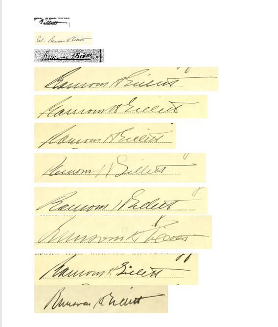
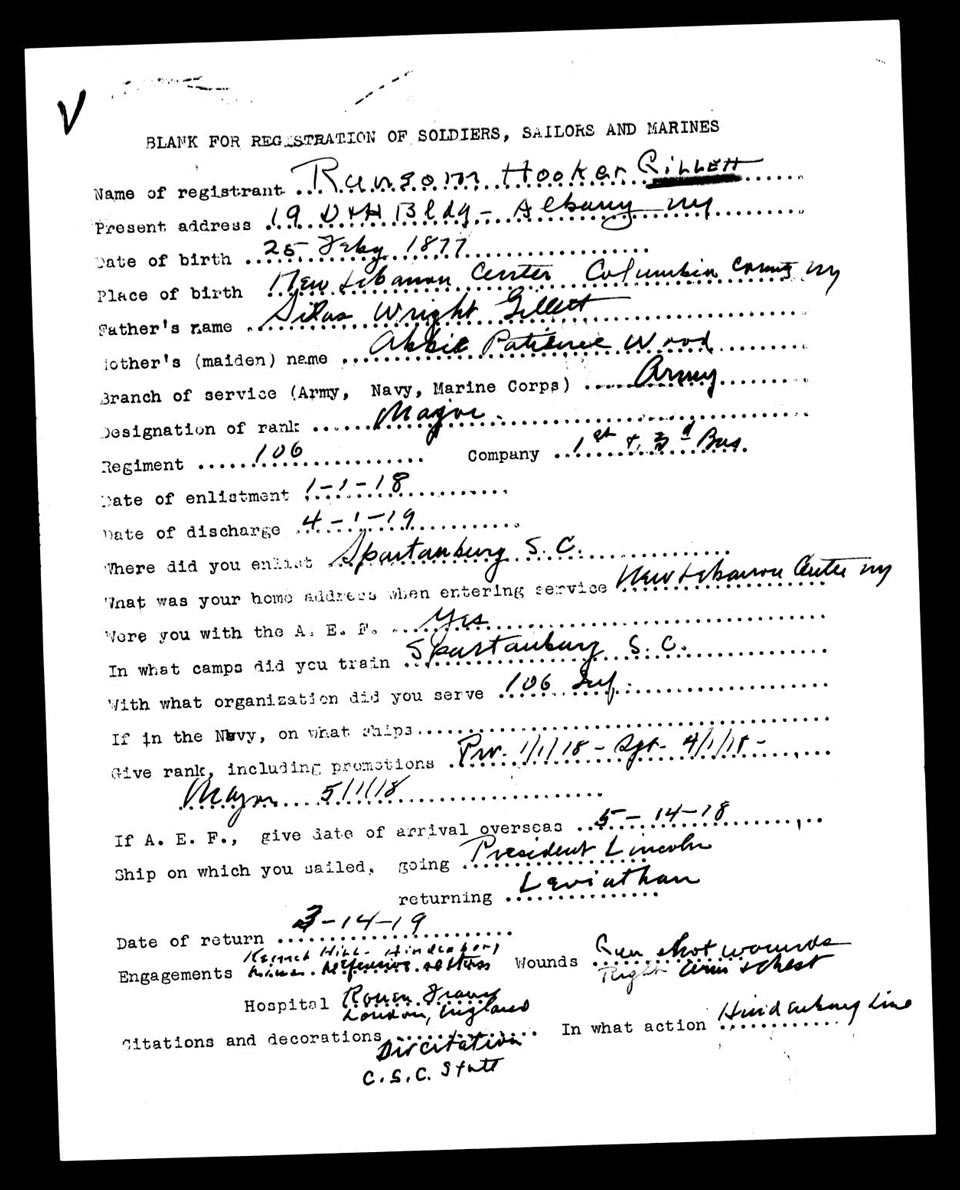
A number of these were taken from military discharge documents and seem to indicate a rushed handwriting style consistent with signing off on a stack of papers in the execution of duties. It should be noted that Karl and I (nor Joe Bausch) were completely convinced that we had a 100% match until Karl came across the following document completely handwritten by Gillett that showed the same distinct mixing of cursive and block letters as well as other particulars that when we compared to the map made us certain we had found our man.
Mystery and Meaning
It was my hope in researching and writing this lengthy document to prove the 1886 provenance of Dorset Field Club’s golf course one way or another, letting the facts and timelines speak for themselves. I went into it with considerable doubt but must admit that during the course of the past few months as I got to know more about the people involved I found myself rooting for it to be true. Still, I hope that isn’t reflected in the findings and that they remain wholly objectively presented.
It was a fascinating process of discovery with too many middle of the night “what if’s” but I’m now confident in the materials presented and their possible meanings and would ask the reader to apply their own critical eye with the same open mindedness, recognizing that if these men were indeed playing golf across pastures with one or a few clubs as early as 1886 they were pioneers indeed in every respect. Given the general lack of knowledge of the game in America at that early time, they would have been a curious sight indeed, and since there were no other people playing and no formal competitions there may have been nothing to really report other than some men of social and sporting prominence having lost their faculties and reduced to chasing little balls around a field with sticks.
So when did Gillett make a copy of the “original map made by A. W. Harrington of the Dorset Golf Links”, dated “Monday, September 13th, 1886, Dorset, VT”? Given his age it’s virtually certain that Gillett didn’t make his copy at that time but likely years later. I would propose that a realistic theory that would explain multiple questions is that he came across an old, likely tattered copy of the original while settling Mrs. Harrington’s affairs after her death in 1940. Again, only a theory but it seems plausible to me given the timing and events.
Was the year really 1886? I still can’t say that with any certainty but we did learn that George B. Harrison first went to Europe in 1888 so if he had a single club perhaps he got it from his wealthy father. Other reports in the 1940s mentioned the year 1893 as the start and we still don’t know the relevance of that date. The one thing we can now say without question in summary is that one Ransom Hooker Gillett, World War One hero who was wounded in action multiple times, prominent lawyer, politician, judge, Major General of the New York State National Guard and vocal opponent of Prohibition tells us from the grave that on September 12th, 1886 Arvin W. Harrington, assisted by “Doc” Holley and “Bill” Kent laid out a nine hole golf course on land we can still recognize today for the enjoyment of themselves and their friends, probably with little idea that someone would find their efforts so fascinating over 135 years later.
“All of which I can swear to” – Ransom H. Gillett
At this point, I really thought I was done. I wrote it up, even sent a copy to Ran Morrissett to publish and a few others to review.
And then, we found the Smoking Gun.
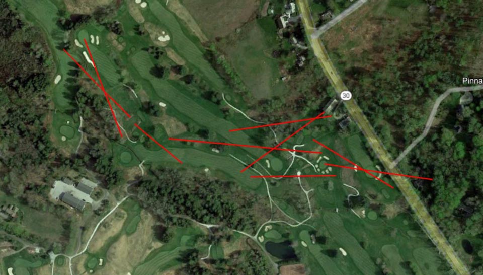
Sometime during the long investigative process I had used Google Earth to attempt to draw a superimposed copy of the original routing map over the golf course as it exists today. I knew the fixed points of the map that included the excavation on today’s 6th, along with some other landforms. I had sent it to Karl Jensen for his review some time back. As it was just an exercise to see how things fit, it wasn’t precise but I figured it was close enough, as such;
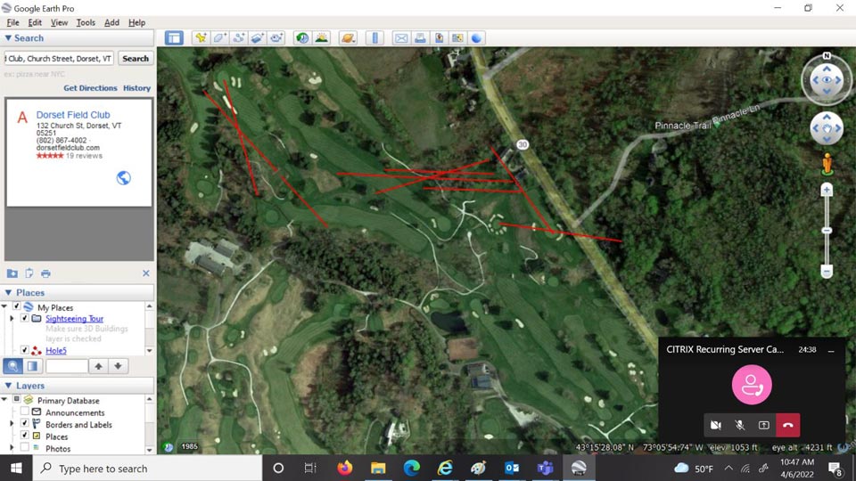
On the morning of April 9th I received the following from Karl;
Mike,
I have been looking hard at your lay over of the 1886 map to Google map. Going on Google Maps I can better see the topography in 3D. I can now see the unused stump hollow of the original 5th and 7th. Very cool!
What seems inconsistent in your lay over, I may be incorrect, shouldn’t the 1886 map 2nd tee be south of the map 1st green, which is today’s 2nd green? You show it being north.
Also you show the 1886 map 9th tee in your lay over playing over what looks like a very old barn on Rt. 30. You can view the old barn on the Google Map street view and you will also see a sharp drop into a ravine just north of the barn where your lay over is depicting the 1886 map 9th tee. If that old barn was there in 1886 perhaps the 9th tee, 3rd green and 4th tee were actually south of it.
Karl was correct and not only did my 9th hole run over a barn but through an adjacent house, as well. Apparently I had made the assumption that whatever buildings were on the property came later, but I reached out to Kevin O’Toole, club Historian for any information he might know about the barn. He shared with me the contents of a talk he had given to the Dorset Historical Society about “The Pinnacle”, which was/is a large stone tower built by a Ms. Cecilia de Nottbeck on a hillside across Route 30 from Dorset Field Club. Included in his presentation was the following;
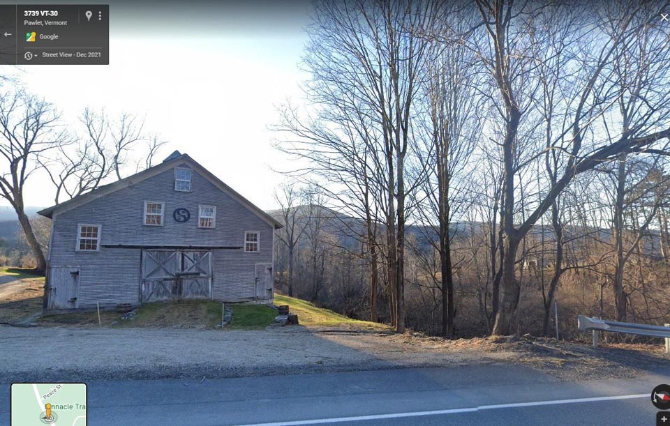
“In 1896, Ms. deNottbeck purchased a house and grounds for her coachmen and built a large barn, with stalls for five teams of horses. This house is now owned by Bill and Wenke Sterns and adjoins the eighth hole at the Dorset Field Club.”
Indeed, in looking at the Gillett map again it appeared to include a house drawn in a rectangular block just south of the 3rd green/4th tee but no barn. It also looks to have something drawn in the back yard. Close examination of the rectangle shows what appears to say “HOUSE” and the backyard structure reads “Bull pen”.
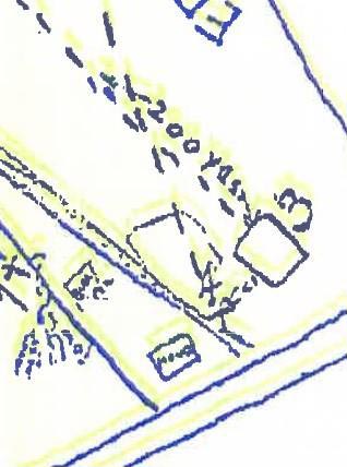
From a street view using Google Maps, here is both the house and the barn as they appear today. It is clear that if it’s the same house sitting on the elevation, or knoll that the barn built around 1896 now occupies what would have been the original 3rd green and 4th tee of the course on Gillett’s map!
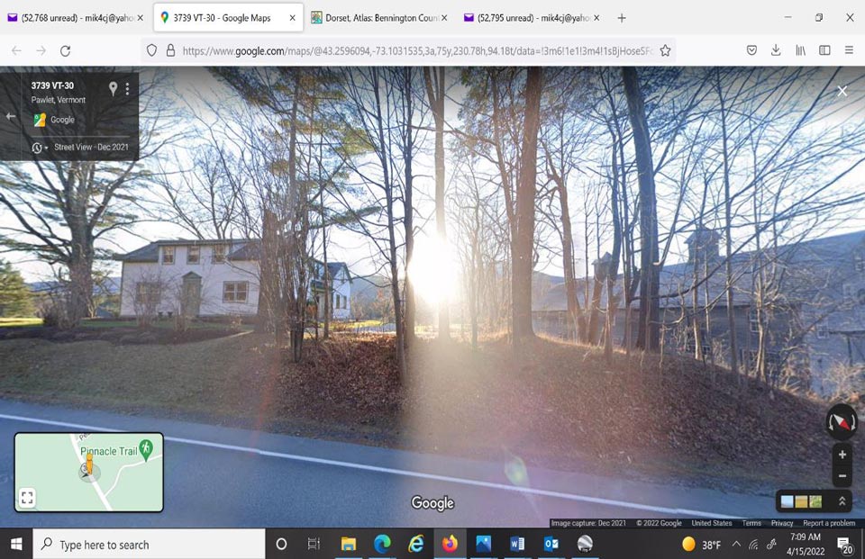
Further, to Karl’s earlier point about a deep ravine being located just north (to the right side of the photo) of the barn that didn’t look particularly suitable for golf purposes here’s a look at that area;
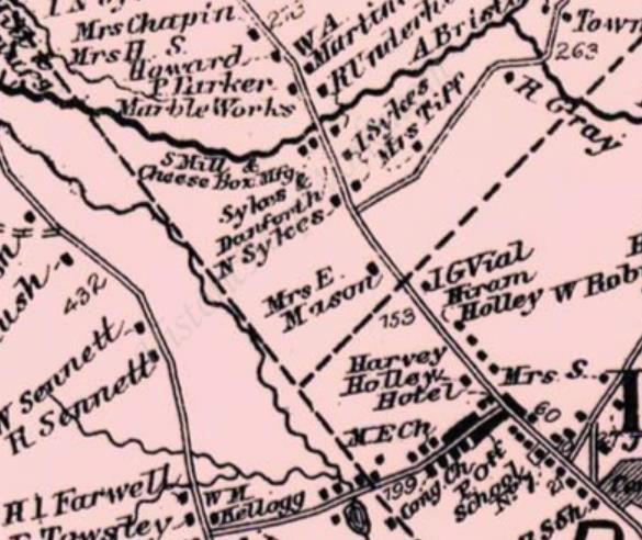
I reached out to the Dorset Historical Society to see if they had any information on the house and when it was built. Following is their response; “Good question. The house does not show up on an 1856 map of Dorset, but it is on an 1869 map, so my guess is that the house was built between those years.”
Here is a portion of the 1869 Dorset map, with the house in question drawn between the “Harvey Holley Hotel” and “N Sykes” properties, apparently owned at the time by Mrs. E. Mason.;
Then Karl found the following snippet clipped from a larger 1954 “Manchester Journal” article about the planned restoration of the Dorset holdings of Ms. deNottbeck. It shows that Ms. deNottbeck purchased the “Ed Frost” place in 1895 that “bordered on the golf course” and “here Miss de Nottbeck “erected several barns and started raising Jersey cattle”;
Karl immediately made the connection between “Ed Frost” and the name of the 1st hole on the Gillett map being “Frost Knoll”. He was then able to determine through census records that Edwin A. Frost, his wife Judith and son Silas are enumerated on the 1880 Dorset, VT Federal Census. By the 1900 Federal Census Ed and Judith had moved to nearby Rupert, VT and Frost died in Rupert in 1908. That finding led us to four conclusions;
- The meaning of the name of the first hole “Frost Knoll”.
- Additional evidence that there was a golf course on the property prior to 1896.
- Ms. deNottbeck and her cattle barn likely necessitated the first routing changes to the original course noted in the earliest scorecard In fact, the 7th hole of the revised course was named “Windhurst”, which was the name of Ms. DeNottbeck’s large estate house across the street.
- Whoever drew the “Gillett” map had to have intimate knowledge of the property prior to the erection of the de Nottbeck barn in 1896 seemingly built on the original 3rd green/4th tee.
That led me to revise the original course map overlay in the following manner which is much more consistent with the landforms and known fixed points;
There was one last piece of the puzzle that Karl and I felt we needed to identify from the Gillett map and that was the “Edgerton Pasture”. As seen above in the 1869 map the “Sykes” and “Holley” pastures line up consistently with the Gillett drawing, which is again reproduced here for reader convenience.
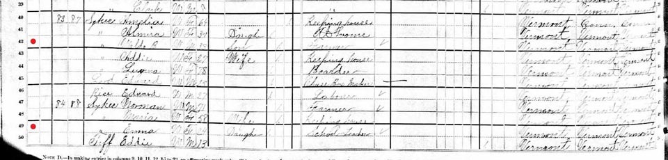
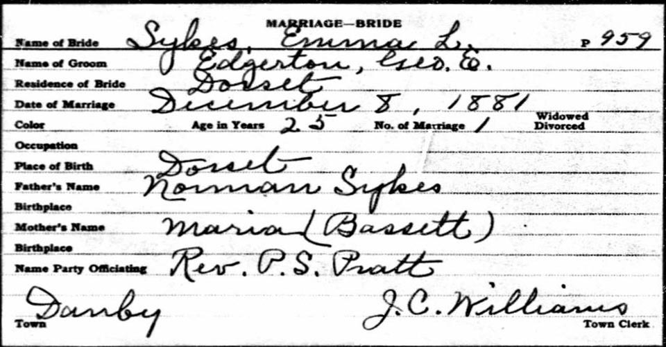
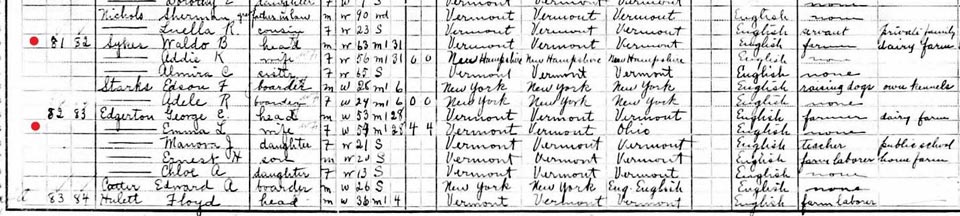
Consistent with “Frost Knoll”, it should be noted as well that the 2nd hole on the Gillett map is named “Edgerton Lot” and the 8th was “Bull Barn”. Again digging through Census and other official records Karl was able to determine that Waldo Sykes (who was a dairy farmer like his dad Ira who was deceased by 1880) and Emma Sykes were cousins who lived adjacent to each other based on their enumeration order. In 1881 Emma married George Edgerton who took over the family farm from her father Norman who was advanced in years. Please see following the 1880 census with Emma still living with her father Norman on the property next to Waldo Sykes, her Marriage record, and the 1910 associated Federal Census. The Dorset Field Club property purchases sent to me by club historian Kevin O’Toole also confirmed the Edgerton lineage, as well as Sykes and Holley.
At this juncture, all of the pieces of the puzzle fit. We now know that Ransom H. Gillett was indeed the author of the map, sometime later copying the original drawn by Arvin W. Harrington in 1886 and that it would have required very specialized knowledge of the who, what, and where that existed on those lands at the time to have created such a detailed and historically accurate document.
Moreover, Karl also found that although the Dorset Field Club was founded in 1896 there was no formal organized golf association at Dorset until 1898, likely with the idea of beginning to play matches against other regional clubs like Ekwanok, Equinox, Mount Anthony and others. This informality of friends playing across several neighborhood pastures would go a long way towards explaining the lack of media coverage prior. This from the August 12, 1898 Granville (VT) Sentinel;
As I was finishing this morning, I received the following from Karl Jensen that I think is a perfect summation. Thank you for those who have read this long document in our journey of discovery that I now hope is definitional to the origins of the game of golf in the United States;
Mike,
I was thinking to myself this morning, when I woke, that I haven’t been able to disprove the 1886 Map. A part of the Medal of Honor grave finding process* is if you can’t prove a grave 100%, can you disprove it. Most graves that are incorrect are easily disproved…
The other thought I had was, why should golf be mentioned in a newspaper article for Dorset, VT before 1898? We have found that to be true with an article stating the organization of the Dorset Golf Club in the summer of 1898 and not in the Dorset Field Club organization of the summer of 1896. My point is if there was no formal golf in Dorset, VT why would it be mentioned in a newspaper article? Would a game of croquet at someone’s private house be reported in a newspaper article unless by chance of whimsy? I don’t think that a lack of newspaper reporting on golf in Dorset, VT before 1898 is any kind of disproof that Arvin and friends were not out on the farm fields dabbling in the sport of golf. Lord knows, Arvin, Joe and friends loved many kinds of sport. Besides, there wasn’t any cell phones or electronic games back then to distract them.
Karl
*Karl Jensen has been a researcher for the past 10 plus years for the Medal Of Honor Historical Society of the United States.
As mentioned earlier, an original copy from the Dorset Field Club is provided below. The version kept at the club is on ledger-size paper.
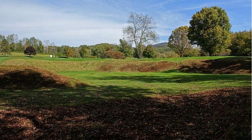
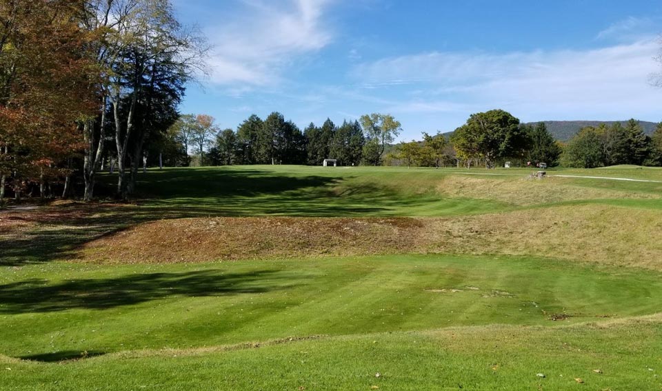
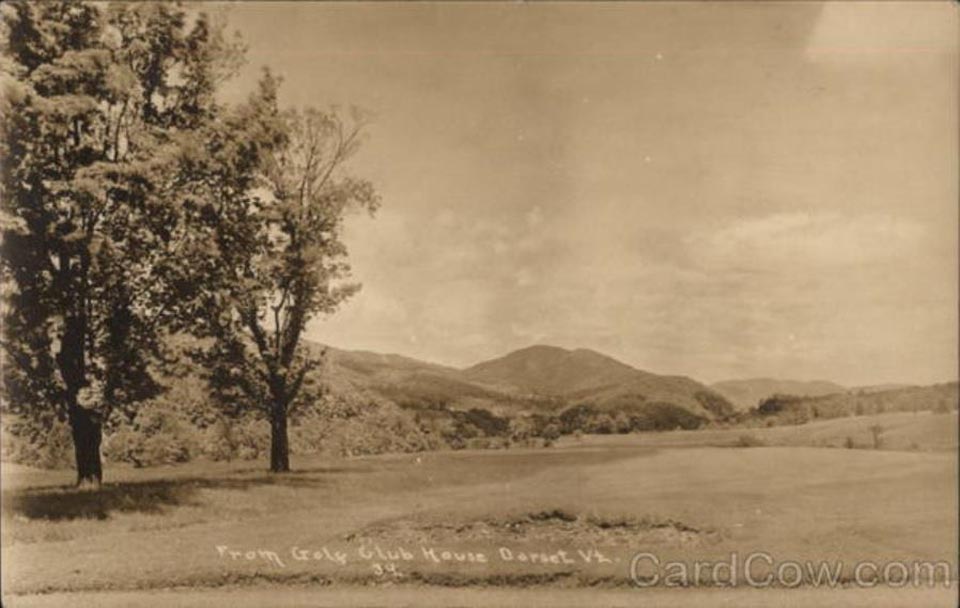
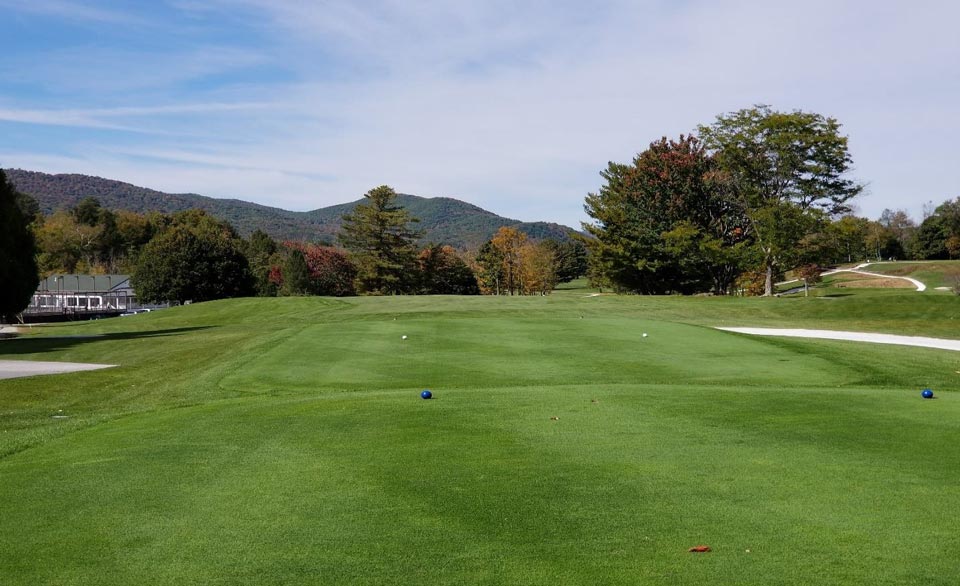
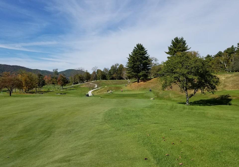
It seems fitting to conclude looking out on the beautiful, rolling golf course of the Dorset Field Club with a view behind the finishing hole in 1912 compared to much the same timeless view taken over a century later, perhaps considering the club’s wonderful, enchanting, and now much more certain history.
————————–
BIBLIOGRAPHY
Dalrymple, W. (1899). Official Golf Guide 1899. USGA Library Digital Asset
Van Tassel, William G. (1900). Harper’s Official Golf Guide 1900. USGA Library Digital Asset
Van Tassel, William G. (1901). Harper’s Official Golf Guide 1901. USGA Library Digital Asset
Brooks Brothers. (1900). The Links Book. USGA Library Digital Asset
Beck, Daniel. (2016). Dorset Field Club: 1886-2016 A Pictorial History. Donning Company Publishers
Floyd, James (1954). Vermont Life – Green Mountain Golf. Vermont Development Commission
Sykes, Gilbert G. (1974). History Of The Dorset Field Club. Presented 12, July, 1974
American Annual Golf Guides. (1927). American Annual Golf Guide(s) 1916-30. USGA Library Digital Asset
English, John P. (1965). Dorset’s Claim as Oldest Club. USGA Golf Journal, September 1965
Dorset Village Historic District. (1985). National Register of Historic Places Inventory – Nomination Form. United States Department of Interior – National Park Service
Case, Forrest N., Sr. (1965). History of the Van Schaick Island Country Club. Case, Forrest N., Sr.
Labbance, Bob (2007). What is the Oldest Continually Operated Golf Club in America?. Golf Collectors Society (The Bulletin – June 2007)
Anderson, George Baker (1897). Landmarks of Rensselaer County, New York. D. Mason and Company
Marbury, John Morton (1902) Golf in Vermont. USGA Journal 1902
Mahoney, Jack. (1973). Golf History of New England. Wellesley Press
Goodner, Ross. (1987). In Search of the Oldest Club. Golf Digest, August 1987
Adler, Max. (2016). Is the Oldest Club in America celebrating its 130th Birthday Today?. Golf Digest September 2016
The Following Newspapers all available online courtesy of www.newspapers.com and/or www.fultonhistory.com
Bennington (VT) Banner
Bennington (VT) Evening Banner
Bennington (VT) Free Press
Berkshire (MA) Eagle
Brooklyn (NY) Daily Eagle
Brooklyn (NY) Life
Clarksville (TN) Leaf Chronicle
Deerfield Valley (VT) Times
Elmira (NY) Star Gazette
Granville (NY) Sentinel
Londonderry (VT) Sifter
Manchester (VT) Journal
New York (NY) Herald
New York (NY) Sun
New York (NY) Times
Rutland (VT) Daily Herald
St. Albans (VT) Daily Messenger
Troy (NY) Daily Times
Vermont (VT) Tribune
The author wishes to express since thanks to Karl Jensen for his investigative spirit and perseverance without which many questions would remain unanswered, Dr. Joe Bausch, aka “Indiana Joe(nes)”, whose critical judgement on theories and facts is scientifically unerring, Tara Valente, Librarian at the USGA Museum and Library in Far Hills, NJ for her enthusiastic and comprehensive assistance, as well as Kevin O’Toole and Patrick McGuire of the Dorset Field Club who welcomed my uninvited queries with open arms and open minds.