News:

This discussion group is best enjoyed using Google Chrome, Firefox or Safari.


Sven Nilsen

  • Karma: +0/-0
Re: Was C.B. Macdonald's routing of NGLA
« Reply #400 on: May 18, 2015, 05:40:38 PM »
The price CBM offered may have been identical, but only one of those offers was accepted.  That says something.
« Last Edit: May 18, 2015, 05:42:58 PM by Sven Nilsen »
"As much as we have learned about the history of golf architecture in the last ten plus years, I'm convinced we have only scratched the surface."  A GCA Poster

"There's the golf hole; play it any way you please." Donald Ross

DMoriarty

  • Karma: +0/-0
Re: Was C.B. Macdonald's routing of NGLA
« Reply #401 on: May 18, 2015, 05:43:53 PM »
1. In his long post a few above, Mike insists that the SHPB development was not adjacent to NGLA.  Here again in this last post Mike contrasts the NGLA site with the previous CBM 120 acre site, as if the NGLA site was somehow remote to the rest of the development. This just isn't true or accurate. NGLA was right next to the SHPB development and NGLA's de facto clubhouse was a key component of the development!

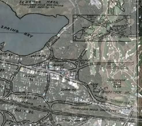
Here is an overlay of a section of that Development which shows that NGLA was adjacent to the development, as was NGLA's de facto clubhouse, the Shinnecock Inn.  


Also, SHPB most certainly viewed NGLA as adjacent to the development, or even part of the development itself!.The advertisements for the SHPB development repeatedly highlighted the proximity and easy access to NGLA from every building lot on the entire development. Indeed, the advertisements treat NGLA as if it were part of the same development, and it some sense this was true, given the prior ownership, the contiguousness of the land, the cooperation (according to Goddard) between CBM and SHPB in locating the Inn/Clubhouse, and the dual role the Inn was playing as on-site headquarters of the development and as NGLA's de facto clubhouse. Here (From Goddard's book) is what the President of SHPB had to say in his annual report to investors at the end of 1906:

In his first report to the stockholders at the end of 1906, he gloated that Macdonald and his co-religionists “intend to make this golf course famous both here and abroad, desiring that it shall be so well known that visiting foreigners and golfers from all over America shall make it a center for this sport. The advantage to your property of having located there two of the oldest and certainly the best of golf courses is obvious.”
   -- Goddard, David (2011-10-24). Colonizing Southampton (Excelsior Editions) (p. 247). State University of New York Press.

The reason it was so obviously advantageous was because it was right there, adjacent to the development, and because it would draw potential customers for both the Inn and the building lots.  

2. In both the long post and in this most recent one, Mike claims that SHPB "considered [the NGLA property] worthless." He is of course taking CBM's description of the pre-purchase property out of context.  

In fact, the SHPB considered the land quite valuable, especially once CBM determined to build what SHPB hyped as the finest golf course in the world on the property. The golf course enhanced the value of the entire development, including the rest of Sebonac Neck, and SHPB was well aware of this even before the sale was final.   Look at CBM's Jan. 1, 1912 letter, where CBM noted that SHPB was reluctant to sell CBM land currently occupied by the pro shop for less than $1000 per acre, and that SHPB had received bids for the land adjacent to the current pro shop of over $1000 per acre.  Or again, see their advertisements, and the quote by their President from late 1906 where he stated, "The advantage to your property of having located there two of the oldest and certainly the best of golf courses is obvious.”

Thanks to the NGLA deal, the value to the SHPB development was "obvious." To everyone but Mike.  
« Last Edit: May 18, 2015, 05:46:20 PM by DMoriarty »
Golf history can be quite interesting if you just let your favorite legends go and allow the truth to take you where it will.
--Tom MacWood (1958-2012)

MCirba

  • Karma: +0/-0
Re: Was C.B. Macdonald's routing of NGLA
« Reply #402 on: May 18, 2015, 06:04:53 PM »
David,

Good to see that you have a copy of the Goddard book.  It's pretty well done.

Of course there was perceived value in having a golf course there even if it didn't work out so well, the company going bankrupt by the early 1920s..  The comments i mentioned from CBM about everyone thinkng the land was worthless were related to housing lots as that area was overgrown and had never been surveyed.  Read the August 1907 article I just posted that describe the conditions at that time

It sounds like they could have done an episode of "Naked and Afraid" there even by that date! ;)  

If the value of the land was so obvious why didn't they just subdivide the rest of Sebonac Neck that CBM didn't use that actually WAS adjacent to NGLA and is today Sebonack Golf Club?  
« Last Edit: May 18, 2015, 06:18:25 PM by MCirba »
"Persistence and determination alone are omnipotent" - Calvin Coolidge

https://cobbscreek.org/

MCirba

  • Karma: +0/-0
Re: Was C.B. Macdonald's routing of NGLA
« Reply #403 on: May 18, 2015, 06:17:15 PM »
The price CBM offered may have been identical, but only one of those offers was accepted.  That says something.

Yes, it tells me that they believed the land near the Shinnecock Canal had much higher value and better proximity and accessibility for building lots than the land they thought more or less worthless on Sebonac Neck.  Would you agree?
"Persistence and determination alone are omnipotent" - Calvin Coolidge

https://cobbscreek.org/

Sven Nilsen

  • Karma: +0/-0
Re: Was C.B. Macdonald's routing of NGLA
« Reply #404 on: May 18, 2015, 06:19:02 PM »
The price CBM offered may have been identical, but only one of those offers was accepted.  That says something.

Yes, it tells me that they believed the land near the Shinnecock Canal had much higher value and better proximity and accessibility for building lots than the land they thought more or less worthless on Sebonac Neck.  Would you agree?

I don't think anyone is arguing that point (except for the last part of that sentence).

But to claim that they were both available to CBM at the same price per acre is faulty logic.
"As much as we have learned about the history of golf architecture in the last ten plus years, I'm convinced we have only scratched the surface."  A GCA Poster

"There's the golf hole; play it any way you please." Donald Ross

DMoriarty

  • Karma: +0/-0
Re: Was C.B. Macdonald's routing of NGLA
« Reply #405 on: May 18, 2015, 06:20:40 PM »
 It wasn't worthless with regard to housing lots, either.   Not-yet-subdivided does not equal worthless.   From the developer's perspective, even the prospect of the golf course brought value to the entire development including the Sebonac Neck property.   By 1911 the developer was being offered over $1000 per acre for land that you claim was worthless.
Golf history can be quite interesting if you just let your favorite legends go and allow the truth to take you where it will.
--Tom MacWood (1958-2012)

DMoriarty

  • Karma: +0/-0
Re: Was C.B. Macdonald's routing of NGLA
« Reply #406 on: May 18, 2015, 06:47:59 PM »
Mike  I see you completely rewrote your post while I was typing mine. I guess I'll have to start using quotes with your posts.

If the value of the land was so obvious why didn't they just subdivide the rest of Sebonac Neck that CBM didn't use that actually WAS adjacent to NGLA and is today Sebonack Golf Club?  

Because, like virtually all developers of large parcels, they were developing their property in phases.

And because, shortly thereafter, CBM's pal bought the entire 300+ acre parcel for his summer residence (or what you'd call his "cabin.")
Golf history can be quite interesting if you just let your favorite legends go and allow the truth to take you where it will.
--Tom MacWood (1958-2012)

MCirba

  • Karma: +0/-0
Re: Was C.B. Macdonald's routing of NGLA
« Reply #407 on: May 18, 2015, 08:20:23 PM »
David,

Macdonald ' s "pal" Charles Sabin purchased that land in 1916.

I have a hard time understanding how a decade is a short time in the Real Estate world?  Wouldn't the Real Estate company have sought to maximize their opportunity to create lots adjacent to the golf course along the length of it given how they all suddenly saw the value of that property after previously considering it worthless according to Macdonald?
« Last Edit: May 18, 2015, 09:21:39 PM by MCirba »
"Persistence and determination alone are omnipotent" - Calvin Coolidge

https://cobbscreek.org/

DMoriarty

  • Karma: +0/-0
Re: Was C.B. Macdonald's routing of NGLA
« Reply #408 on: May 18, 2015, 09:30:15 PM »
According to CBM, the developer had offers on Sebonac Neck land adjacent to NGLA of over $1000/AC around 1911. Then around 1916 the developer sold that entire Sebonac Neck property to Sabin. That seems like a pretty short time in real estate development terms to me, but I really don't care whether you think it short or not.  My points remain the same regardless.

Besides, it doesn't matter what you think or what I think, it matters what the developer thought:

1. In the opinion of the developer in 1906-1907, the creation of NGLA would greatly enhance the value of the entire development, including the NGLA parcel and the entire Sebonic Neck property. If you've read Goddard, read CBM's 1912 statement, and read the advertisements, then you know that the developer didn't think the property was "worthless" given that CBM was planning NGLA.

So why are you pretending that the developer thought the property was worthless?

2. Likewise, you know that NGLA was to start and finish at the Inn, which was part of the development, and that the development itself was adjacent to the Inn and the golf course.  You know that the roads built by the development went right to the Inn and the developers improvements were focused on the Inn. You know that course was was right there, and that in the developer's opinion in 1906-1907 the course's location was a major enhancement to the development.

So why are you pretending that the course wasn't right there?  

These are the types of issues that make these discussions with you so frustrating. You implore me to treat you with respect and then you play these silly games, arguing for days that the golf course wasn't next to the development when it was treated as a feature of the development itself.
« Last Edit: May 18, 2015, 09:38:06 PM by DMoriarty »
Golf history can be quite interesting if you just let your favorite legends go and allow the truth to take you where it will.
--Tom MacWood (1958-2012)

Patrick_Mucci

Re: Was C.B. Macdonald's routing of NGLA
« Reply #409 on: May 18, 2015, 11:24:26 PM »

Here is some more information, from what looks to me like a very reliable source, about the history of the clubhouse at NGLA.

I  think your unnamed "reliable source" is unreliable.
Would you care to name him/it ?

They were playing the course in 1909, and that included playing the current 1st and 18th holes, between which is where the clubhouse sits


In the summer of 1910, two years after the Shinnecock Inn burned down, Macdonald finally decided that he wanted to build his clubhouse on the site where it sits today, on a hill overlooking Peconic Bay. 

It appears that in 1910 that he did not own the site on which the clubhouse is sited. 

That's pure unadulterated nonsense.
They owned the land and were playing the current 1st and 18th holes.

Or is it your position that they were playing golf in 1909 on land that CBM/NGLA didn't own ?  ?  ?

Macdonald stated that they took title to the property in the Spring of 1907 and held an informal event in 1909, when John Ward played the holes (today's first 4 holes) in 2-2-4-2..

Macdonald also stated that he won his flight with a one up victory over Robert Watson, meaning that they had to play all 18 holes.

Which means that all of the land that presently constitutes the current golf course was owned by CBM/NGLA in 1909.

To maintain that CBM/NGLA didn't own the land between # 1 and # 18 is ...............


The Realty Co offered to sell him the 2.5 acre site where the clubhouse now sits, but only as a site for the clubhouse.
After some negotiation he bought the parcel of land and assisted by a committee had the clubhouse built over the summer of 1911 and completed by September.  They tried to fund the clubhouse through the issuance of debentures.

"Only as a site for the clubhouse"  ?
What else could it be, the golf course, including the 1st and 18th holes were already built.


The fact that he didn't own the clubhouse site in 1910 throws a wrench in my understanding of what property he did buy in 1906-07. 

That's NOT a fact.
That's an allegation by an unnamed source, one probably from the Philadelphia area if I was to make a guess.


Did they buy property with a lot in the middle withheld, or did the property not originally go as far west as the current 18th green and 1st tee?

Read Scotland's gift for clarification.
They owned the land that included the 1st and 18th holes.


At any rate, it appears certain that this site for the clubhouse is not where he always intended it be.  If it was, I imagine that he would have thought to buy the site as part of the original land deal in 1906.

It was were it was always intended to be and they did buy it in the original land deal in 1907.

Your unnamed source is incorrect.

Hey, it happens

P.S.  I'll be back


Patrick_Mucci

Re: Was C.B. Macdonald's routing of NGLA
« Reply #410 on: May 18, 2015, 11:26:43 PM »

Very interesting Bryan.  It would be fascinating to find the original metes and bounds but the routing extended to the current first and 18th holes from the get go, as depicted in the Aug 1907 article showing the routing.

Mike,

My god man, you'll jump at and support any fabrication that supports your wild theories.

In 1909 NGLA's routing included the current 1st and 18th holes.

But, don't take my word for it, take CBM's.


Patrick_Mucci

Re: Was C.B. Macdonald's routing of NGLA
« Reply #411 on: May 18, 2015, 11:54:46 PM »

Re the roads situation, I have crudely overlaid the 1904 topo onto the modern Google aerial and marked the improved roads in red and the unimproved around Sebonac Neck in orange(Yellow).  I also marked the location of the Shinnecock Inn.  Looks like the SI site was surrounded by a triangle of unimproved dirt tracks in 1904.  Presumably the developer hardened at least one of those tracks for automobile traffic when they built the Inn.  

Mike, did you not read Bryan's article from March, 1908 stating that in addition to the three new roads, that a previous highway system had already been built.

Here's Bryan's article.


There were a number of tracks into the NGLA site that probably would have been sufficient, without improvement, for construction activities, at least in decent weather.  I still wonder why there were those tracks up in the Neck in 1904 when there are no structures up there and nothing down to the north side of the tracks except for the SHGC clubhouse.  Where did those tracks go to through the brambles and who would have used them.  The supposedly better properties for cottages and beaches were all supposed to be south of the tracks.

Mike, if you were familiar with the area you'd know that they go exactly where they go today, to the Peconic Bay.
Remember, in 1905 NGLA was private property and undeveloped..
I'm not so sure that the shoreline road was "brambles" as you suggest.
My guess is that the road leading to Peconic Bay was for fishing, the beach and perhaps boating.
It would provide access to the clubhouse site.


What remains unanswered is where was the site CBM originally intended for his clubhouse near the Shinnecock Inn.  It looks like there were dirt tracks that could have been improved right there to serve a clubhouse site.  The new Shinnecock Inn was supposed to be electrified, so availability of electricity at that site might have been a consideration too.


Bryan,

Thanks for providing that map.

I came upon this 1905 Automobile Club Map that is interesting to compare and contrast.

Interestingly, it doesn't appear to show any roads passable by automobile up into the NGLA property.

Of course it does.
You're looking to far to the East/Northeast.


For reasons of my interest, it also doesn't show any roadways of signfiicance north of the railroad tracks going back to the Shinnecock Canal that would have negatively impacted CBM's first choice for his ideal golf course near there.

I think what fairly could be said, which I've tried to point out despite attempts to shout me down, is that this area was a work in progress, a "moving picture" between the years of 1905 when the Real Estate company bought the land, CBM's subsequent failed attempt to secure 120 acres, the securing of 200 acres of Sebonac Neck property in late 1906, and soft opening of the course in 1910.

But, we know that CBM bought 205 acres for NGLA in 1907

And we know that wagons/trucks made 20,000 trips to an from NGLA on roads that could accomodate heavy loads of dirt.
 

Somewhat futilely, in my opinion, the discussion keeps getting sidetracked with silly things like what year the Dump Truck got invented (around 1907-08) and whether they would have been deployed, when Macdonald never mentioned using trucks in the first place.

It doesn't matter if he mentioned dump trucks, trucks or wagons, 20,000 trips were made to and from NGLA on roads that would accomodate those vehicles.
And, of those 20,000 trips, 10,000 were made with those vehicles carrying heavy loads of dirt.

Mike, you're looking at the wrong area.
NGLA is next to Cold Spring Inlet, NOT Sebonac Neck.

The entire North-South road along Sebonac Creek and Bullhead Bay is adjacent to NGLA, giving ample access to the golf course.

I'm surprised at you  ;D


« Last Edit: May 19, 2015, 12:51:23 AM by Patrick_Mucci »

Patrick_Mucci

Re: Was C.B. Macdonald's routing of NGLA
« Reply #412 on: May 19, 2015, 12:20:41 AM »
To whomever it may concern re the GIS Viewer topo map I posted:


Quote
You should be more careful with what you rely on for your information.


Quote
Why didn't you take Bryan to task for posting a gross misrepresentation.


Quote
why you didn't you take Bryan Izatt to task for posting flawed information.


For the record, the GIS Viewer is the property of Suffolk County.  Suffolk County is responsible for naming streets in their jurisdiction.  I suspect they know the street names in their jurisdiction better than Patrick does.  If you take a wider view (see below), you can see that White's Lane comes from the east and enters NGLA property, goes north past some maintenance buildings and continues up the middle of the course (just as Patrick previously said it did) towards the current clubhouse where there is a short disconnect before it angles back out the east.  So, the County obviously still considers the whole road to be White's Lane.  Perhaps it is all still a public road.  I'll leave it to Patrick to prove it's not.

That's easy.
White's Lane ENDS where those grey buildings appear in the lower portion of the map.
That's the old maintenance shed.
The road in the county GIS labeled White's Lane is the private driveway leading to the NGLA clubhouse.

Access to the original clubhouse was via White's Lane, which is no longer an, as you say, improved road.
It's basically a dirt cart path beyond the old maintenance shed.


In the end, I will rely on the Suffolk County GIS Viewer as an accurate topo map  and as factual about the road's name.  I will not rely on Patrick's opinions, misguided and argumentative as they are.

I now understand the phrase, "ignorance is bliss"


Too bad that the quality of the topo map gets lost in Patrick's stupid argumentative diversions.

If you had ever been to NGLA you'd know that I'm right and that your source map is wrong.
A private driveway that ends in a circle at the clubhouse entrance is a driveway, not a thoroughfare or road and definitely not White's Lane.


Patrick_Mucci

Re: Was C.B. Macdonald's routing of NGLA
« Reply #413 on: May 19, 2015, 12:48:15 AM »

For the record, the GIS Viewer is the property of Suffolk County. 
Suffolk County is responsible for naming streets in their jurisdiction. 
I suspect they know the street names in their jurisdiction better than Patrick does. 

You're WRONG again.
There is NO street, only a driveway on private property.
Do you now think that the county is naming driveways ?

Go to Google Maps for verification


Google Maps is more factual than the County GIS Viewer?!  :o  Back to the dunce corner for you.

Yes, in this instance it is.
White's Lane in the County GIS is a DRIVEWAY, not a thoroughfare, not a road or street.
A driveway that ends in a circle at the front entrance to the clubhouse.
Now why don't you look at Google Maps, or Google Earth and see where White's lane begins and ends.
It has NO connection to the driveway at NGLA


If you take a wider view (see below), you can see that White's Lane comes from the east and enters NGLA property, goes north past some maintenance buildings and continues up the middle of the course (just as Patrick previously said it did) towards the current clubhouse where there is a short disconnect before it angles back out the east. 

No, it doesn't.
It ends in the maintenance area.
Just look at Google Maps and Google Earth for verification.

105 years ago that was the original entrance to the clubhouse.
At that location you will find the original entrance gate confirming same when you make the left off of Sebonac Inlet Rd into White's Lane.


So, the County obviously still considers the whole road to be White's Lane. 

NO, the county doesn't consider the whole road to be White's lane.
The road (White's Lane) ends at the old maintainance shed.
It does NOT continue past the old maintenance sheds as you would say, as an "improved" road.
It's basically a dirt cart path and does NOT connect to the driveway.
You would know that if you ever visited NGLA

Then why did they label it that way?.

You'd have to ask them


Why don't you get a statement from the County to prove your opinion.


I don't need to.
Anyone who's been to NGLA knows that I'm correct
Why don't you look at Google Earth for verification.


And, as you enter NGLA from Sebonac Inlet Rd, the massive gates greet you along with notices that it's private property.
When I'm there next I'll take pictures for you.

No need.  I know what the sign says.  Whether the road is private or not does not mean it is not named in County records.

But, it's not a road.
It's a private driveway.
Why don't you look at Google Earth to get an idea as to what you're talking about.

The road you claim is White's Lane is on private property.
It is the driveway leading to the clubhouse and NOT a public road.
Obviously, you've never been there to see for yourself
[/size]

Shrubland Road crosses private property but is a public road..

Not True.
Shrubland Road does NOT cross private property.
It separates private property.
Again, if you had been to NGLA you would know that.


The Google Maps source you rely on shows two named roads, Rd C and E Rd, running down the middle of NGLA.  
Because Google names them does that mean they're public?[/size]


There are NO roads "C" and "E"
There are paths, basically cart paths, but, no roads, so perhaps your source needs to update it's files.


Perhaps it is all still a public road. 

It is NOT a public road.
It's on private property and is the club's driveway.
[/size]

I'll leave it to Patrick to prove it's not.

Anyone who has been to NGLA knows it's private property and the driveway into the club.

But, please feel free to keep insisting that it's a public road.
I like it when you're wrong but redouble your efforts. ;D

Perhaps you missed the word "perhaps".  Good to see you bite.  Good thing you can type fast without reading and understanding.  By the way, roads on private land are not named on Long Island?

Wow, you sure tricked me with the word "perhaps"
Once again, it's a private driveway, not a road.
You already acknowledged that the sign next to the entrance states that it's private property, and I'll foolishly assume that you know the difference between a driveway and a road.  Please view Google Earth for verification, unless you think Google Earth is as flawed as Google Maps


In the end, I will rely on the Suffolk County GIS Viewer as an accurate topo map  and as factual about the road's name. 
I will not rely on Patrick's opinions, misguided and argumentative as they are.

You can rely upon the SCGISV all you want.
The road you allege is a public road is a private driveway.


I said perhaps to bait you.  You bit.  What does that have to do with the factual basis of the SCGISV, as you call it.

WOW, again your mastery at baiting and debating comes to the fore.
Please look at Google Earth, then get back to us.


Too bad that the quality of the topo map gets lost in Patrick's stupid argumentative diversions.

Too bad that Google Maps and Google Earth agrees with me.
Zero in on the driveway and let me know if it says White's Lane, OR, if White's Lane enters the property by the 13th hole.

Too bad you missed the point - again.


At some point you're going to have to admit that I'm right and that you and your Suffolk County GIS Viewer are wrong..


I think in good conscience that you had better tell Suffolk County that they are wrong and that they'd better get together with Google to get it right. I wonder (not really) where you think Google gets the information that it put on it's maps?

So you're of the opinion that government agencies never make mistakes ?
Like mistaking a driveway from a road ?


Do you have the fortitude to do that ?

My argument is factually correct and you've obviously been led down the wrong path, and a private one at that


No, unfortunately you've relied on a flawed, outdated source.

Hey, it happens.


Bryan Izatt

  • Karma: +0/-0
Re: Was C.B. Macdonald's routing of NGLA
« Reply #414 on: May 19, 2015, 01:39:08 AM »
Patrick,


You're baaaaaaack.  I could tell from the flood of green phosphor.  ;D


...........................


The fact that he didn't own the clubhouse site in 1910 throws a wrench in my understanding of what property he did buy in 1906-07. 

That's NOT a fact.
That's an allegation by an unnamed source, one probably from the Philadelphia area if I was to make a guess.


The source material said that Macdonald didn't own the site where the current clubhouse sits.  It was stated as fact.

Earlier in the thread you said that if someone couldn't refute your opinion, then your opinion had to be treated as fact.  So, back to you.  Refute this claim or treat it as fact.  By the way, David and Sven have offered opinions on why this fact can't be right.  Their opinions make some sense.  But they do not completely refute this claim.  The deeds would.

Sorry to disappoint you but the source is not from the Philadelphia area.  You should ask your anonymous NGLA source.


Did they buy property with a lot in the middle withheld, or did the property not originally go as far west as the current 18th green and 1st tee?

Read Scotland's gift for clarification.
They owned the land that included the 1st and 18th holes.


I said that the source I had said that NGLA didn't own the clubhouse site - I said nothing about the 1st and 18th holes.

I suppose it would surprise you to know that part of the 1st tee was on Realty Co. land originally.

I guess it would also surprise you to know that SHGC recently built a new 3rd tee that infringed on NGLA property.  Apparently even in the 21st century things get built on land that isn't owned.


At any rate, it appears certain that this site for the clubhouse is not where he always intended it be.  If it was, I imagine that he would have thought to buy the site as part of the original land deal in 1906.

It was were it was always intended to be and they did buy it in the original land deal in 1907.

Your unnamed source is incorrect.

Could be, but until we find the deeds to prove where the 2.5 acres they bought in 1910 for the clubhouse actually was, we don't know for sure.

Hey, it happens

P.S.  I'll be back


Bryan Izatt

  • Karma: +0/-0
Re: Was C.B. Macdonald's routing of NGLA
« Reply #415 on: May 19, 2015, 01:55:18 AM »
Patrick,

Did you leave your brain somewhere over the weekend and forget to bring it back with you?   ;)

Reread the article - you don't seem to understand it.

You seem confused about who, Mike or I, wrote what below.

and, btw, the Automobile Club misplaced Sebonac Neck on their map.  That's really Cow Neck.  You do know that, don't you?   ;D


Re the roads situation, I have crudely overlaid the 1904 topo onto the modern Google aerial and marked the improved roads in red and the unimproved around Sebonac Neck in orange(Yellow).  I also marked the location of the Shinnecock Inn.  Looks like the SI site was surrounded by a triangle of unimproved dirt tracks in 1904.  Presumably the developer hardened at least one of those tracks for automobile traffic when they built the Inn.  

Mike, did you not read Bryan's article from March, 1908 stating that in addition to the three new roads, that a previous highway system had already been built.

Here's Bryan's article.


There were a number of tracks into the NGLA site that probably would have been sufficient, without improvement, for construction activities, at least in decent weather.  I still wonder why there were those tracks up in the Neck in 1904 when there are no structures up there and nothing down to the north side of the tracks except for the SHGC clubhouse.  Where did those tracks go to through the brambles and who would have used them.  The supposedly better properties for cottages and beaches were all supposed to be south of the tracks.

Mike, if you were familiar with the area you'd know that they go exactly where they go today, to the Peconic Bay.
Remember, in 1905 NGLA was private property and undeveloped..
I'm not so sure that the shoreline road was "brambles" as you suggest.
My guess is that the road leading to Peconic Bay was for fishing, the beach and perhaps boating.
It would provide access to the clubhouse site.


What remains unanswered is where was the site CBM originally intended for his clubhouse near the Shinnecock Inn.  It looks like there were dirt tracks that could have been improved right there to serve a clubhouse site.  The new Shinnecock Inn was supposed to be electrified, so availability of electricity at that site might have been a consideration too.


Bryan,

Thanks for providing that map.

I came upon this 1905 Automobile Club Map that is interesting to compare and contrast.

Interestingly, it doesn't appear to show any roads passable by automobile up into the NGLA property.

Of course it does.
You're looking to far to the East/Northeast.


For reasons of my interest, it also doesn't show any roadways of signfiicance north of the railroad tracks going back to the Shinnecock Canal that would have negatively impacted CBM's first choice for his ideal golf course near there.

I think what fairly could be said, which I've tried to point out despite attempts to shout me down, is that this area was a work in progress, a "moving picture" between the years of 1905 when the Real Estate company bought the land, CBM's subsequent failed attempt to secure 120 acres, the securing of 200 acres of Sebonac Neck property in late 1906, and soft opening of the course in 1910.

But, we know that CBM bought 205 acres for NGLA in 1907

And we know that wagons/trucks made 20,000 trips to an from NGLA on roads that could accomodate heavy loads of dirt.
 

Somewhat futilely, in my opinion, the discussion keeps getting sidetracked with silly things like what year the Dump Truck got invented (around 1907-08) and whether they would have been deployed, when Macdonald never mentioned using trucks in the first place.

It doesn't matter if he mentioned dump trucks, trucks or wagons, 20,000 trips were made to and from NGLA on roads that would accomodate those vehicles.
And, of those 20,000 trips, 10,000 were made with those vehicles carrying heavy loads of dirt.

Mike, you're looking at the wrong area.
NGLA is next to Cold Spring Inlet, NOT Sebonac Neck.

The entire North-South road along Sebonac Creek and Bullhead Bay is adjacent to NGLA, giving ample access to the golf course.

I'm surprised at you  ;D


Bryan Izatt

  • Karma: +0/-0
Re: Was C.B. Macdonald's routing of NGLA
« Reply #416 on: May 19, 2015, 02:06:43 AM »
Patrick,

Now I'm worried about you.    :o   This was more than 100 posts ago and you've already spewed forth on this.  Is this a better response than your last one from before your lost weekend.

And, you're still wrong.


To whomever it may concern re the GIS Viewer topo map I posted:


Quote
You should be more careful with what you rely on for your information.


Quote
Why didn't you take Bryan to task for posting a gross misrepresentation.


Quote
why you didn't you take Bryan Izatt to task for posting flawed information.


For the record, the GIS Viewer is the property of Suffolk County.  Suffolk County is responsible for naming streets in their jurisdiction.  I suspect they know the street names in their jurisdiction better than Patrick does.  If you take a wider view (see below), you can see that White's Lane comes from the east and enters NGLA property, goes north past some maintenance buildings and continues up the middle of the course (just as Patrick previously said it did) towards the current clubhouse where there is a short disconnect before it angles back out the east.  So, the County obviously still considers the whole road to be White's Lane.  Perhaps it is all still a public road.  I'll leave it to Patrick to prove it's not.

That's easy.
White's Lane ENDS where those grey buildings appear in the lower portion of the map.
That's the old maintenance shed.
The road in the county GIS labeled White's Lane is the private driveway leading to the NGLA clubhouse.

Access to the original clubhouse was via White's Lane, which is no longer an, as you say, improved road.
It's basically a dirt cart path beyond the old maintenance shed.


In the end, I will rely on the Suffolk County GIS Viewer as an accurate topo map  and as factual about the road's name.  I will not rely on Patrick's opinions, misguided and argumentative as they are.

I now understand the phrase, "ignorance is bliss"


Too bad that the quality of the topo map gets lost in Patrick's stupid argumentative diversions.

If you had ever been to NGLA you'd know that I'm right and that your source map is wrong.
A private driveway that ends in a circle at the clubhouse entrance is a driveway, not a thoroughfare or road and definitely not White's Lane.


Bryan Izatt

  • Karma: +0/-0
Re: Was C.B. Macdonald's routing of NGLA
« Reply #417 on: May 19, 2015, 02:24:48 AM »
Patrick,

Re post #413.  I couldn't help but laugh when I read it.  You've risen to new heights of absurd logic. 

Long live Google Earth (or was that Google Maps?) the ultimate authority on all geographical things.

The GIS Viewer is a nice topo map application. Too bad that got lost in your rants about road naming.   :( :'(


Bryan Izatt

  • Karma: +0/-0
Re: Was C.B. Macdonald's routing of NGLA
« Reply #418 on: May 19, 2015, 02:45:54 AM »
Re the two articles below - these things always lead me to wonder.

One article says that the bluff at the 8th green is 80 feet above Peconic Bay.  The other says that the clubhouse sits 150 feet above the Bay.  Now, by the time CBM had the blueprint (whenever that was) he had the elevations on the course and he knew that the highest elevation anywhere on the property was 57 feet.  The highest point is on the 2nd fairway across from the Sahara bunker.  It was then and it is still today.  How can the news reports so grossly exaggerate the elevations?

One other thing from the first article below.  It states that the 9th tee is the most westerly point of play while leading in to talk about the 10th hole.  Presumably they meant the 10th tee.

Also in that article, it says that the 9th hole starts slightly north of west and then in the last third of the hole "dipping well to the southward".  The description seems to be of a dogleg left.  That doesn't sound like the current hole.  Could the 9th have been initially routed differently than we think.  It has been said that the course played shorter in the tentative 1909-10 time frame. Would some of that shortening have been around the 9th and 10th?  I don't know, just some questions.   


Bryan Izatt

  • Karma: +0/-0
Re: Was C.B. Macdonald's routing of NGLA
« Reply #419 on: May 19, 2015, 03:09:14 AM »
One more newspaper report of a real estate transaction for NGLA - this one in November 10, 1911 from the County Review.  Why did they buy 4 acres and where was it?  And, why did this valuable land sell for only $200 for 4 acres.


« Last Edit: May 19, 2015, 11:01:43 AM by Bryan Izatt »

Bryan Izatt

  • Karma: +0/-0
Re: Was C.B. Macdonald's routing of NGLA
« Reply #420 on: May 19, 2015, 03:15:53 AM »
And, two other interesting snippets from the County Review.  The first from December 13, 1912.  Environmental (or was it commercial) considerations in 1912?


And, the other also from the County Review on May 3, 1907 - Mortimer Payne hired "to lay out" the course.


« Last Edit: May 19, 2015, 11:04:34 AM by Bryan Izatt »

MCirba

  • Karma: +0/-0
Re: Was C.B. Macdonald's routing of NGLA
« Reply #421 on: May 19, 2015, 06:15:02 AM »
Bryan,

Cool, thanks.

What day was the Payne article?
"Persistence and determination alone are omnipotent" - Calvin Coolidge

https://cobbscreek.org/

MCirba

  • Karma: +0/-0
Re: Was C.B. Macdonald's routing of NGLA
« Reply #422 on: May 19, 2015, 07:02:09 AM »
Bryan,

It is difficult to tell from that line drawing two weeks later whether the 18th was routed slightly differently prior to the clubhouse.  From the writer's description, it sounds odd but perhaps the author had contracted malaria with high fever by that point of his tour of the course.  ;)
"Persistence and determination alone are omnipotent" - Calvin Coolidge

https://cobbscreek.org/

Jeff_Brauer

  • Karma: +0/-0
Re: Was C.B. Macdonald's routing of NGLA
« Reply #423 on: May 19, 2015, 07:50:40 AM »

__________________________________________________________

Jeff,
There is a very simple explanation as to why CBM didn't take 1.5AC of land within NGLA - He wanted a 200 acre estate and bought one right next door.

Applying your same logic, there is a very simple explanation of why CBM never carved out 60-70 residential lots out of the NGLA property --He wanted from the beginning to use the entire parcel for a golf course.

You know there is no connection between the two logically.

Quote
I am not sure how you can look at that graphic and claim the border hugs the golf course in its entirety.  You seem to be ignoring it to make your point. It does everywhere but the 17th, where there is an extra 60-90 yards of land from the edge of the fairway.  CBM said there was extra land after the fact, the map shows extra land by 17, so really, that has to be what he was talking about, no?

Again, Jeff, you are misunderstanding my position.  What I said was that the eastern border was locked by the physical characteristics of the property (Peconic Bay, Bullshead Bay, Shinnecock GC), and it had already been determined by mid December 1906.  CBM only had room to manipulate the border to the west, and the eastern border fits snugly to property. 

Your mistake notwithstanding (about east and west) how is my question misunderstanding your position? Why is it relevant? I asked two simple questions - 1) do you see the 60-90 yards of land near 17 not used for golf? (2 Do you think this is the surplus land CBM mentioned in 1912? One of the reasons these things go 20 pages or more (yes, I am confident that this will do that!) is that you manage to talk past any direct point that might refute your position, by misdirection.  Just do as you ask Mike to do, answer the damn question! :)

[/color]
Jeff Brauer, ASGCA Director of Outreach

Sven Nilsen

  • Karma: +0/-0
Re: Was C.B. Macdonald's routing of NGLA
« Reply #424 on: May 19, 2015, 09:14:47 AM »
Bryan:

It would be helpful if you could provide full citations for the articles you posted.

Thanks,

Sven
"As much as we have learned about the history of golf architecture in the last ten plus years, I'm convinced we have only scratched the surface."  A GCA Poster

"There's the golf hole; play it any way you please." Donald Ross

Tags:
Tags:

An Error Has Occurred!

Call to undefined function theme_linktree()
Back