News:

This discussion group is best enjoyed using Google Chrome, Firefox or Safari.


Jeff_Brauer

  • Karma: +0/-0
Re: Pine Valley and Topos
« Reply #475 on: August 27, 2011, 12:08:31 PM »
That stick route plan note is another indication (to me, at least) that Crump worked primarily on the ground, not routing off topos.  He may have confirmed with topos, of course.
Jeff Brauer, ASGCA Director of Outreach

Mike Cirba

Re: Pine Valley and Topos
« Reply #476 on: August 27, 2011, 12:47:13 PM »
NGLA was routed circa 1906-1907 via topo and lots of field study.  (EDIT - That's a theory, not known for certain)

Pine Valley was not unique in this respect, much less the original use of topos.

In fact, we know that Crump hit shots from all over that property to locate his holes...not sitting with some lifeless map.
« Last Edit: September 06, 2011, 02:23:10 PM by MCirba »

Jeff_Brauer

  • Karma: +0/-0
Re: Pine Valley and Topos
« Reply #477 on: August 27, 2011, 02:04:55 PM »
Merion was routed with a topo.  At least we know they had one made specifically by Feb 1, with routing occurring in March and April.  We know the committee drew many plans, and Francis spent many hours drawing plans, and we know he had the idea for the last four holes well past dark, so he must have been doing that on paper.

Plus, apparently CBM knew you needed topos to route a course (in conjunction with field study) by June 1910, because he told Merion he needed one to do any kind of routing,  but didn't have one.

So, the idea that PV was a pioneer in using topos doesn't seem right, based on the record of just the few courses we have discussed here.  Who really knows what other professional gca types in that early era were doing.  TMac might have a better idea than I, having studied that era extensively.
Jeff Brauer, ASGCA Director of Outreach

Tom MacWood

  • Karma: +0/-0
Re: Pine Valley and Topos
« Reply #478 on: August 27, 2011, 02:06:23 PM »
That stick route plan note is another indication (to me, at least) that Crump worked primarily on the ground, not routing off topos.  He may have confirmed with topos, of course.

It is an indication someone was working on the ground...either Crump and the original group intending to design the course or Colt. Colt would be the more logical choice.

Tom MacWood

  • Karma: +0/-0
Re: Pine Valley and Topos
« Reply #479 on: August 27, 2011, 02:07:22 PM »
NGLA was routed circa 1906-1907 via topo and lots of field study.

Pine Valley was not unique in this respect, much less the original use of topos.

In fact, we know that Crump hit shots from all over that property to locate his holes...not sitting with some lifeless map.

Where did you read the NGLA was routed using a topo?

Tom MacWood

  • Karma: +0/-0
Re: Pine Valley and Topos
« Reply #480 on: August 27, 2011, 02:08:31 PM »
Merion was routed with a topo.  At least we know they had one made specifically by Feb 1, with routing occurring in March and April.  We know the committee drew many plans, and Francis spent many hours drawing plans, and we know he had the idea for the last four holes well past dark, so he must have been doing that on paper.

Plus, apparently CBM knew you needed topos to route a course (in conjunction with field study) by June 1910, because he told Merion he needed one to do any kind of routing,  but didn't have one.

So, the idea that PV was a pioneer in using topos doesn't seem right, based on the record of just the few courses we have discussed here.  Who really knows what other professional gca types in that early era were doing.  TMac might have a better idea than I, having studied that era extensively.

Where do you guys come up with this stuff?

Jeff_Brauer

  • Karma: +0/-0
Re: Pine Valley and Topos
« Reply #481 on: August 27, 2011, 03:41:40 PM »
Well, unlike you, none of it came from train schedules.  Not as sure about the NGLA stuff,  but the Merion stuff was all documented in club records.  Of course, we don't need to go there.

As to my suggestion that you might have an understanding of that era better than most, well, I may have been whacked out when I wrote THAT! (insert smile)
Jeff Brauer, ASGCA Director of Outreach

Tom MacWood

  • Karma: +0/-0
Re: Pine Valley and Topos
« Reply #482 on: August 27, 2011, 04:23:51 PM »
You are the most consistently confused person on this site. CBM did not tell Merion he needed a topo map to do a routing. The letter mentions nothing about routing the golf course. He was asked to give his opinion of the property before they purchased it, and that is exactly what he did as well as give some advice about drainage and treatment of the soil. He does mention that he thought it would be possible to build a first class 18-hole golf course on that given acreage with the addition of a few more acres near the clubhouse, but cautions that judgement was made without the advantage of a contour map. There is no evidence a topo map was ever made at Merion. No one knows who routed Merion, nor do we know if that person or persons used a topo map. Other than that your speculation is spot on.
« Last Edit: August 27, 2011, 04:37:12 PM by Tom MacWood »

Patrick_Mucci

Re: Pine Valley and Topos
« Reply #483 on: August 27, 2011, 05:03:14 PM »
Patrick,

As much as I would love to bow out of these discussions, as long as you are talking solely the development of PV, I might offer some stuff up.  Go to the Tillie site (you have the link in an email) and in Tillies March 1915 article on PV, he notes that Crump "discoverd" the new 13th hole while clearing trees for the 12the green.

Jeff, I had heard conflicting reports about the credit for the 13th hole.
Interesting that the AWT society cedes credit to Crump.


While just a snippet, that implies that George was very much a field type of guy, even that late in the development process. 
One has to accept, that spending years on site, qualifies GAC as being in the field, but, it doesn't necessarily lead to the conclusion that the routing and hole designs were the product of strictly field work, or field work more than work with topos.

It's apparent that GAC had missing pieces to the puzzle (12, 13, 14 & 15), even after years of study, so one would expect him to be in the field and working off of topos.


BTW, it also mentions taking muck from nearby low lying areas for topsoil in another article, which almost certainly had to be the pond of 14. 

Again, I"m going to disagree with the "almost certainly" attribution.
They could have been referencing the areas fronting the 18th green, on the 5th hole or near the entrance roadway as well.
I don't think you can opt for # 14 to the exclusion of the other locations.


Maybe making that lake had nothing to do with design, but more agronomy.

That's certainly possible.

The fact that holes 12, 13, 14 & 15 remained missing for so long, indicates that GAC was stumped for some time, yet, holes # 17 and # 18 were in place, as was # 11.

Understanding the terrain, I can see that he faced the dilema of traversing the steep slope from the upper part of the course to the lower part of the course while at the same time having to contend with and avoid the swamp.

The dual, red/blue topo provides some insight as to their dilema.
I believe that the swampy area, now the lake by # 15/# 16 was viewed as hostile territory.


Just a thought.

Patrick_Mucci

Re: Pine Valley and Topos
« Reply #484 on: August 27, 2011, 05:08:03 PM »

NGLA was routed circa 1906-1907 via topo and lots of field study.

NGLA was NOT routed with a topo.
That's a total fabrication on your part.


Pine Valley was not unique in this respect, much less the original use of topos.

Pine Valley was unique in that respect.
Even the Idiot-Savant TEPaul agrees with me on that point.

Topos were NOT a common tool in designing/routing of golf courses in 1910.


In fact, we know that Crump hit shots from all over that property to locate his holes...not sitting with some lifeless map.

Is that why they called him "old black and blue" ?
From the golf balls bouncing off the trees and hitting him.

Crump ONLY hit shots AFTER he had cleared the corridors of the intended holes.

The clearing of trees in the playing corridors came first, not afterwards, as you would incorrectly have us believe.


Patrick_Mucci

Re: Pine Valley and Topos
« Reply #485 on: August 27, 2011, 05:14:36 PM »

Merion was routed with a topo.  At least we know they had one made specifically by Feb 1, with routing occurring in March and April.  We know the committee drew many plans, and Francis spent many hours drawing plans, and we know he had the idea for the last four holes well past dark, so he must have been doing that on paper.

That doesn't mean a topo was used as the primary tool for creating the golf course and the individual holes.


Plus, apparently CBM knew you needed topos to route a course (in conjunction with field study) by June 1910, because he told Merion he needed one to do any kind of routing,  but didn't have one.

That's not true,
CBM requested topos because he was doing the work in absentia.


So, the idea that PV was a pioneer in using topos doesn't seem right, based on the record of just the few courses we have discussed here.  

I disagree and so does TEPaul according to our most recent phone conversation.


Who really knows what other professional gca types in that early era were doing.

Field staking seemed to be quite common.

Are you aware of any courses between 1900 and 1910 that were designed primarily through the use of topos in the U.S ?

I don't consider a survey to be a topo.
A topo is elevation specific.


TMac might have a better idea than I, having studied that era extensively.

Agreed.


Mike Cirba

Re: Pine Valley and Topos
« Reply #486 on: August 28, 2011, 10:08:46 AM »
If Ran hired a full time, independent "fact checker", much like some news agencies employ during general elections to separate factual information from pure BS and purposeful misinformation, said fact-checker would have more cleanup from the past two days of posting than FEMA will after Hurricane Irene.

Strangely, 90% of the sewage is bright GREEN!  ;)  ;D

I can't keep up with the cleanup work needed here, but if one starts somewhere around the point where Browns Mills, NJ is strangely moved from Burlington to Camden Co., there is enough effluent flowing here to keep the earth a fertile planet for the next 1000 years.
« Last Edit: August 28, 2011, 11:59:43 AM by MCirba »

Jeff_Brauer

  • Karma: +0/-0
Re: Pine Valley and Topos
« Reply #487 on: August 28, 2011, 11:04:23 AM »
Mike,

We have all posted mistakes, in some cases, I have been called out from posting from memory and missing a few key words, etc.  Or, making a logical leap that others don't find logical, at least within the framework of a Philly argument!

This is reaching the point where we could all cite others opinions from memory, as these threads usually do.  Will one more post of Patrick's in green type really convince anyone else of exactly what Shelly was trying to say?  I doubt it, and I doubt you or I will convince anyone of anything anyway.

In fact, in one of the posts above, Pat says we cannot know just how much topos were used vs field walks.  So, why more green type, or responses from us?  After all, we cannot know!

This is just the typical brats (myself included) sniping at others, not adult discussion, and certainly not historical discovery.

Short version:  We all know its time to end this, but at the same time, its time to place your bets in Vegas on the over/under for pages on this thread!  Got to hedge your bets!
Jeff Brauer, ASGCA Director of Outreach

Mike Cirba

Re: Pine Valley and Topos
« Reply #488 on: August 28, 2011, 12:11:23 PM »
Tom MacWood,

"Seth Raynor was born in Suffolk County in 1878 and settled in
Southampton as a surveyor. Employing him to survey our Sebonack
Neck property, I was so much impressed with his dependability
and seriousness I had him make a contour map and later gave him
my surveyor's maps which I had brought from Scotland and England,
telling him that I wanted those holes laid out faithfully to
those maps. For three to four years he worked by my side." - Charles Blair Macdonald

"As I stated in my agreement to associate with me two qualified
golfers in America, making a committee of three to carry out this
general scheme, I asked Jim Whigham and Walter Travis as associates.
Eventually I dropped Travis, and .Jim vVhigham and myself,
with the kindly interest taken by Joseph P. Knapp, James A. Stillman,
Devereaux Emmet, Charles A. Sabin, and others, forged
ahead with the construction from the surveyors' maps and the thirty
or forty drawings which I had made myself abroad of different
holes which I thought were worth while. These drawings were not
necessarily copies of the particular hole from tee to the putting.
green, but in most instances were of the outstanding features which
I thought made the hole interesting and which might be adapted to
a hole of different length. Two or three of such features might be
put in a hole which would make it more or less composite in its
nature." - Charles Blair Macdonald

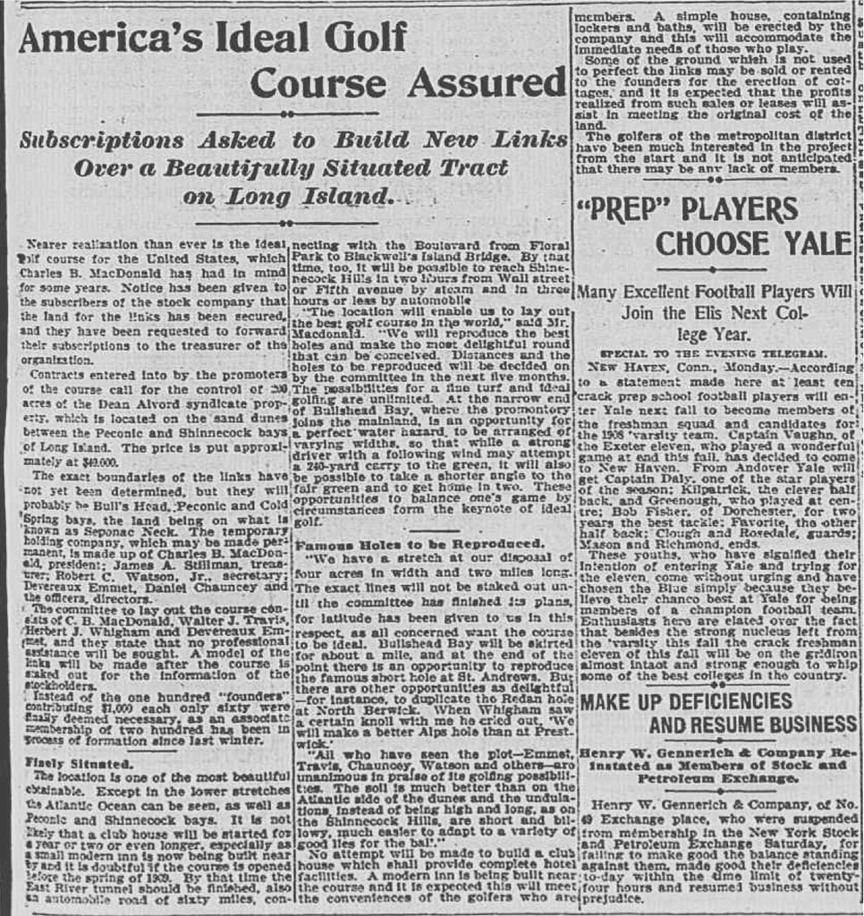
Or this article, from December 1906...


I'd be interested in your take on how NGLA was routed if you don't believe a contour map was involved.   For purposes of our discussions, I'm defining "routing" as the location of 18 tees, fairways, and greens.  

Thanks.


Patrick,

You keep telling Jeff he'd agree with your train ride nonsense if he was more familiar with the property, yet everyone here who is very familiar with the property including me, Jamie, Sully, Tom Paul, Dan Hermann, and others say you are full of crap.  

The only ones to give you any credence have strangely never been there.   Amazing.


« Last Edit: August 28, 2011, 12:56:40 PM by MCirba »

Mike Cirba

Re: Pine Valley and Topos
« Reply #489 on: August 28, 2011, 12:30:41 PM »
Patrick,

I think everyone here agrees with Shelly, especially the last sentence of what he wrote.

The funny thing is you have constantly misrepresented Shelly, first purposefully trying to deceive everyone here by omitting the last line of what he wrote and then following by telling us that Shelly offered "proof" that the train story wasn't true when he said no such thing.   All he said is that he had proof that Crump had hunted the ground prior, offering a photo of Crump sitting in the woods as evidence.

While we'd all like to know how Shelly made that determination from the picture (i.e. he told us nothing further to define his analysis),  and we all agree that if the picture was dated and Crump mentioned on the back that he was on today's PV property that would indeed be proof, it still doesn't change Shelly's further explaining that both stories are likely true.


Your attempts to take your initial deception to even greater depths by calling Tillinghast a liar are not only historic revisionism at its worth, its sad, pathetic, and disgraceful.
« Last Edit: August 28, 2011, 12:38:12 PM by MCirba »

Patrick_Mucci

Re: Pine Valley and Topos
« Reply #490 on: August 28, 2011, 03:59:13 PM »
If Ran hired a full time, independent "fact checker", much like some news agencies employ during general elections to separate factual information from pure BS and purposeful misinformation, said fact-checker would have more cleanup from the past two days of posting than FEMA will after Hurricane Irene.

Strangely, 90% of the sewage is bright GREEN!  ;)  ;D

I can't keep up with the cleanup work needed here, but if one starts somewhere around the point where Browns Mills, NJ is strangely moved from Burlington to Camden Co., there is enough effluent flowing here to keep the earth a fertile planet for the next 1000 years.

Mike, so after 14 pages and almost five hundreds replies, the only flaw in my presentation, the only error you can find is that I listed Browns Mills in Camden County instead of Burlington County.

I've asked you over and over again to cite where I lied or where my facts were wrong, and the only thing you can come up with is that I listed the unincorporated area of Browns Mills in Camden County instead of Burlington County.

I'd say that more than anything reinforces my position and my presentation.

I forgot, weren't you the one that maintained that Crump was a field guy, that he was hitting balls through the oaks, pines and jungle like undergrowth to phantom greens and DZ's on land they hadn't cleared yet


archie_struthers

  • Karma: +0/-0
Re: Pine Valley and Topos
« Reply #491 on: August 28, 2011, 05:05:01 PM »
 ??? ::) ???

If only I could have seen into the future, surely Mr Shelley  would have been quizzed on this one!  Isn't he saying he's not sure why Crump settled on this plot of land, but clearly recognized it's potential for golf?

Without exhuming Crump's body and re-animating him along with Peter Falk , this puppy will continue ad infinitum .....how about using your talents on some new material?

Joe Bausch

  • Karma: +0/-0
Re: Pine Valley and Topos
« Reply #492 on: August 28, 2011, 05:32:48 PM »
??? ::) ???

If only I could have seen into the future, surely Mr Shelley  would have been quizzed on this one!  Isn't he saying he's not sure why Crump settled on this plot of land, but clearly recognized it's potential for golf?

Without exhuming Crump's body and re-animating him along with Peter Falk , this puppy will continue ad infinitum .....how about using your talents on some new material?

Like.
@jwbausch (for new photo albums)
The site for the Cobb's Creek project:  https://cobbscreek.org/
Nearly all Delaware Valley golf courses in photo albums: Bausch Collection

Patrick_Mucci

Re: Pine Valley and Topos
« Reply #493 on: August 28, 2011, 05:44:02 PM »
Archie,

You're the lucky one, you haven't been bombarded by the seemingly hundreds of inane emails from TEPaul on this and related subjects.

Whatever you do, don't reveal your email address  ;D

As to Shelly, no, I don't think he's saying that.
He used strong words, "proof" and Testimony of that fact" and he produced a 1909 photo of Crump on PV prior to the course being selected.

But, I do think he's pacifying those who like to preserve myths ;D

Hope all is well

How bad is the damage and flooding in your neck of the woods ?

archie_struthers

  • Karma: +0/-0
Re: Pine Valley and Topos
« Reply #494 on: August 28, 2011, 07:04:44 PM »
 ;D ;D   ;D

No worries for me !   We were spared in my town Ocean City but Greate Bay lost some trees, many when  the wind cranked up this afternoon fortunately the golf course really drains well, so  the rain isn't a big issue. Lots of places have suffered with the hot wet conditions.
l
I'm guessing that the financial losses are becoming pretty acute for some of our neighboring golf courses.  An early hurricane and clean up didn't help them!
« Last Edit: August 29, 2011, 12:10:30 AM by archie_struthers »

Patrick_Mucci

Re: Pine Valley and Topos
« Reply #495 on: August 28, 2011, 07:14:34 PM »
;D ;D   ;D

No worries for me !   We were spared in my town Ocean City but Greate Bay lost some trees, the wind cranked up this afternoon . the golf course really drains well, so as long as it stays cool, all is well!

I'm guessing that the financial losses are becoming pretty acute for some of our neighboring golf courses.  An early hurricane and clean up didn't help them!


Yes, but think of all the tree removal they can do by blaming Hurricane Irene.

Dan Herrmann

  • Karma: +0/-0
Re: Pine Valley and Topos
« Reply #496 on: August 28, 2011, 07:33:46 PM »
Patrick - absolutely yes.  This is a great opportunity to do some removal and blame the storm to nay-sayers.

Tom MacWood

  • Karma: +0/-0
Re: Pine Valley and Topos
« Reply #497 on: August 28, 2011, 11:12:34 PM »
Mike
Where did you read the NGLA was routed using a topo?

CBM said the property was surveyed at some point, but we have no idea when, and he said a contour map was used during construction. The two earliest plans for the course that I'm aware of are the blueprint in the CBM biography and the schematic on the first scorecard, and neither is a topographic plan. The blueprint looks to be the oldest.
« Last Edit: August 28, 2011, 11:26:54 PM by Tom MacWood »

Tom MacWood

  • Karma: +0/-0
Re: Pine Valley and Topos
« Reply #498 on: August 29, 2011, 06:48:30 AM »
Patrick,

I think everyone here agrees with Shelly, especially the last sentence of what he wrote.

The funny thing is you have constantly misrepresented Shelly, first purposefully trying to deceive everyone here by omitting the last line of what he wrote and then following by telling us that Shelly offered "proof" that the train story wasn't true when he said no such thing.   All he said is that he had proof that Crump had hunted the ground prior, offering a photo of Crump sitting in the woods as evidence.

While we'd all like to know how Shelly made that determination from the picture (i.e. he told us nothing further to define his analysis),  and we all agree that if the picture was dated and Crump mentioned on the back that he was on today's PV property that would indeed be proof, it still doesn't change Shelly's further explaining that both stories are likely true.


Your attempts to take your initial deception to even greater depths by calling Tillinghast a liar are not only historic revisionism at its worth, its sad, pathetic, and disgraceful.

How is it sad, pathetic and disgraceful? I believe everyone agrees Tilly lied about Crump's death. And the train story is obviously bogus, other wise you could have answered my questions with reasonable answers. We have the letter to his friends from September 1912, where he tells them he has discovered the site. How could he have discovered the site early 1910, and then rediscovered it almost three years later? That makes no sense. Why was he looking at other inland sites in 1912, if had already discovered this most spectacular site.

Shelley's rationalization makes no sense either, but of course most of the local myths make no sense. I don't care how dense the vegetation, if you are walking over the site you will know it is rolling in nature, you are going to see all the valley's and streams, and you are going to know it is largely sand based. If he was hunting over the site in 1909 then he did not discover it by train in 1910.

Crump told his friends he discovered the site in the latter half of 1912, and that is what I believe. It is very strange how the local hero's first person accounts are often ignored in the process of perpetuating these local myths.
« Last Edit: August 29, 2011, 06:53:29 AM by Tom MacWood »

Mark Chaplin

  • Karma: +0/-0
Re: Pine Valley and Topos
« Reply #499 on: August 29, 2011, 07:01:13 AM »

This would be a better site if all of these petty debates involving a handful of armchair detective were conducted by entirely email and the rest of us were left to have reasonable debate and discussion.

Cave Nil Vino

Tags:
Tags:

An Error Has Occurred!

Call to undefined function theme_linktree()
Back