News:

This discussion group is best enjoyed using Google Chrome, Firefox or Safari.


Patrick_Mucci

Re: The Creation of NGLA in Chronological, Contemporaneous News Articles
« Reply #1075 on: March 23, 2011, 02:07:37 PM »
Jim,

I"m going to show you how disingenuous Mike is being.

Notice how he conveniently fits his new phantom golf course, which he's now made narrower into the map.
Now he's shifted the course further North, using the North Highway as his southern border.
Notice how he told you where the North Highway ran in 1903.

There's only one problem, here's the 1903 New York State map.


Look closely at the little cape/bay on the southern portion of Cold Spring Pond.
Do you see how the North Highway runs right through that section, right along the southern border of Cold Spring pond.
Now look at Mike's newest version of his golf course.


Notice how the 1903 North Highway would run right smack down the middle of his phantom golf course.

Mike keeps shifting the size, location and configuration of his phantom golf course to suit the map of the day.

You should also know that the distance between the southernmost portion of Cold Spring Pond and the Atlantic Ocean is probably less than 1,320 yards, making Mike's newest version a course that would probably require foursomes to walk "single file"

Patrick_Mucci

Re: The Creation of NGLA in Chronological, Contemporaneous News Articles
« Reply #1076 on: March 23, 2011, 02:42:48 PM »

I can't tell if you are being honest or not, so I'll give you the benefit of the doubt.

That April 1907 "map" I posted is NOT a map.
It's a PLAN.

It's a plan BASED ON  A MAP OF THE AREA, INCLUDING COLD SPRING POND, THE EXISTING NORTH HIGHWAY AND THE EXISTING RAILROAD.


It does not reflect reality....it reflects what the company ENVISIONED.

IT DOES REFLECT REALITY UNLESS YOU'RE GOING TO INSIST THAT THE RAILROAD, COLD SPRING POND AND OTHER FEATURES  DIDN'T EXIST IN ORDER TO SUIT YOUR PRE-DETERMINED CONCLUSIONS?


By that time, CBM had ALREADY SELECTED his land further to the northeast, and it's indicated on the map.
As you can see, it was virtually all DUE NORTH of the land of Shinnecock Hills GC.

That PLAN also has the supposed North Highway running right over today's  10th tee at NGLA.

That's your interpretation


IT WAS NEVER BUILT along the Red Line I indicated on that map and I have to believe YOU KNOW THAT.
IT DIDN"T EXIST at all along that stretch in 1907 and I have to believe YOU KNOW THAT.

OF COURSE IT DID
The Shinnecock Inn was sited ON the NORTH HIGHWAY IN 1906.
How can you deny the North Highway's existance in the face of the 1906 New York State Senate Documents, citing its existance ? ?  ?

How can you deny its existance in the 1903 New York State map ?  ?  ?


The maps you posted from 1903 and 1905 show a road, a smaller dirt road, running along but much further south towards the railroad tracks and NOT in the area where I drew the hypothetical golf course.  

You must be out of your mind.
Here's the 1903 Map.
The North Highway hugs the southern shore of Cold Spring Harbor.
How can you blatantly lie about these things ?


Back then there was plenty of area between Cold SPring Bay and that dirt road, all the way from Shinnecock out past the inlet to build a golf course.   Plenty.

Take another look, the North Highway is right up against Cold Spring Pond at its southernmost point


Besides, if any part of it did affect any proposed golf plans, what did exist as a road north of the tracks was so marginal and infrequently used (with all of 18 houses in existence in all of Shinnecock Hills at the time, all most all of them south of the tracks) that there is no doubt that any of it interfering with any grander plans like a golf course could have been easily moved/replaced as Alvord saw fit.   Today's cart paths have more permanence and structure.

Mike, when you make comments like that, you lose more and mre of your credibility
You reference Shiinnecock Hills as if there was nothing else on the South Fork.
No Montauk, No Sag Harbor, No Southampton.
Again, that's disingenuous on your part


It was so marginal Pat, that even by 1914 it was NOT included on a highway map of NYC and Long Island, yet the South Highway was clearly shown.

On the map you presented, The South Highway was the ONLY road shown on the entire South Fork in 1914, despite the fact that the Shinnecock Inn was sited on the North Highway in 1906.  Didn't you read their advertisements ?
Why do you constantly ignore the 1906 New York State Senate documents which clearly confirm the exisitance of the North Highway
   

Not even big enough to be considered...I almost feel sad for it.
Bryan has shown you that, I've now explained it in almost childlike terms and I hope that's the end of it.

Bryan may be closer to my position than yours
What's amazing is how you continue to ignore the 1906 New York State Senate documents confirming the existance of the North Highway in 1906, just as it's about to run right rhrough your phantom golf course


If you're confused, then perhaps you should slow down and read more carefully before continuing to fire personal insults and angry barrages.


I don't consider refuting blatant misrepresentations and lies as personal attacks, but, I can see why you'd want to categorize them in that fashion

Some last questions.

Do you consider the 1906 New York State Senate document to be authentic ?

Do you consider the advertisement for the Shinnecock Inn to be atuhtentic.

Do you consider the June 2nd, advertisement for Shinnecock Hills to be authentic

Do you consider the  1903 New York State map to be authentic

Please answer those 4 questions


Mike Cirba

Re: The Creation of NGLA in Chronological, Contemporaneous News Articles
« Reply #1077 on: March 23, 2011, 03:07:03 PM »
Patrick,

I'm starting to worry about you, but at least your sense of humor seems to be slightly returning so I'll take that as a good sign.

Holy cow...you think that the North Highway ran through the 1st tee at NGLA when it was built?!?!   THAT is what's proposed on that April 1907 Land PLAN!   Egads, Patrick!   Please get a grip!!

As far as walking single file...

Here is a modern aerial.   I've drawn three lines.  

The first on the left shows what would have been the narrowest point of what I proposed, from the edge of Peconic Bay to an actual road that looks close to traversing the same route as whatever that old dirt road was on those 1905 maps.   It is 200 yards.

The next shows the distance from the northern boundary I proposed to the actual North Highway that was eventually built MANY years later.   It's 400 yards, actually 405 yards to be precise.


The last line, which actually more reflects the reality of the time, shows that it was over 750 yards from that boundary to the rail line, where there is PLENTY of room to re-route a dirt road if necessary.  

I went to look at NGLA and measured the width at various points.

Would you like to hear them?


« Last Edit: March 23, 2011, 03:10:06 PM by MCirba »

Mike Cirba

Re: The Creation of NGLA in Chronological, Contemporaneous News Articles
« Reply #1078 on: March 23, 2011, 03:21:23 PM »
And Patrick...

Since your humor is returning, I thought you might enjoy this one.

I called CBM's office on Wall Street asking for him to return my call.

I'm trying to reach him before he goes ahead and builds his National Golf Links on Sebonac Neck!

Holy smokes...I just discovered that there's a freaking HIGHWAY running right through it!!  ;)  ;D


David,

Sorry...don't think I'll get your questions answered today but will try tomorrow.

I'm very hopeful they'll help to get us on a better tone here.
« Last Edit: March 23, 2011, 03:39:07 PM by MCirba »

Patrick_Mucci

Re: The Creation of NGLA in Chronological, Contemporaneous News Articles
« Reply #1079 on: March 23, 2011, 03:43:05 PM »
Mike,

Are you now agreeing with me about the North Highway running right down the middle of your golf course ?

That's the original entrance to the clubhouse that enters the property at the Eden hole, it's not the main East-West commercial Highway.  I pointed that out on the 1903 New York State Map.

If, according to you, the North Highway was no more than a dirt cart path, this must have been a deer track.

Now this was a road to nowhere, terminating on the bluff above the Peconic Bay, as opposed to the Main Artery for East-West traffic on the North Shore of the South Fork.

Since you wanted to draw a distinction between the types of roads in existance in 1906, it's only fair that you do so with this road to nowhere. ;D


Mike Cirba

Re: The Creation of NGLA in Chronological, Contemporaneous News Articles
« Reply #1080 on: March 23, 2011, 03:59:07 PM »
Patrick,

I'd say the road above the Railroad Tracks was a one lane sandy golf cart path.

The road up through NGLA was a path through the brambles, wide enough for one man and his angry, bleeding horse.  ;)  ;D

Some widths on today's NGLA, admittedly at the narrow points;

* Turning Area of 9th green - 94 yards

* Width of portions of 9th Fairway/10th fairway - 195 yards

* Width of numbers 8 and 11 at points - 215 yards

* Width of area of 7th green across 11 - 259 yards

* Width of area of 3rd tee/15th fairway - 231 yards

* Width of area just short of 18th green across 1st tee - 180 yards.

And Patrick...for an "out and back" golf course, the widths at NGLA are HUGE, reflecting the generally humongous fairways, some of which are over 100 yards wide in spots, which generally reflect the strategic options CBM wanted to present for all levels of players, but primarily to create avenues of play "around" hazards for the weaker players.

If you think about what's realistic on most modern courses.....perhaps 35 yard wide fairways with 50 yard buffer zones between each hole I'd think you could realistically route an out and back course in under 170 yards of width.

Perhaps Jeff or some other professional could weigh in on that question.

Andy Hughes

  • Karma: +0/-0
Re: The Creation of NGLA in Chronological, Contemporaneous News Articles
« Reply #1081 on: March 23, 2011, 04:21:38 PM »
Don't want to derail you guys while you're having a good time, but am I correct is saying that the only reason for these many pages on the North Highway and whether it existed or not is because if it did exist then it definitely/maybe/doubtfully ran down the middle of the alternate site Mike proposed? I realize that sounds pejorative but I really don't mean it to be--just want to make sure I am following along.

"Perhaps I'm incorrect..."--P. Mucci 6/7/2007

JESII

  • Karma: +0/-0
Re: The Creation of NGLA in Chronological, Contemporaneous News Articles
« Reply #1082 on: March 23, 2011, 04:33:04 PM »
I think you've pretty well got it...I wouldn't hang the blame on any one person but the whole debate hinges on the suggested possible location described in the October articles...

Andy Hughes

  • Karma: +0/-0
Re: The Creation of NGLA in Chronological, Contemporaneous News Articles
« Reply #1083 on: March 23, 2011, 04:41:12 PM »
Thanks Jim. Definitely not blaming anyone for anything--just want to make sure I haven't missed something.
"Perhaps I'm incorrect..."--P. Mucci 6/7/2007

Mike Cirba

Re: The Creation of NGLA in Chronological, Contemporaneous News Articles
« Reply #1084 on: March 23, 2011, 04:55:03 PM »
Andy,

Yes, in this strange bizarre land we call GCA, you've nailed it exactly.   ;)  ;D

I am perplexed how my suggestion as to the location of the site in those articles has taken us to this point, but we sure do love our minutiae here, and I also think some just like to argue, as well.   ;)

DMoriarty

  • Karma: +0/-0
Re: The Creation of NGLA in Chronological, Contemporaneous News Articles
« Reply #1085 on: March 23, 2011, 04:57:21 PM »
Don't want to derail you guys while you're having a good time, but am I correct is saying that the only reason for these many pages on the North Highway and whether it existed or not is because if it did exist then it definitely/maybe/doubtfully ran down the middle of the alternate site Mike proposed? I realize that sounds pejorative but I really don't mean it to be--just want to make sure I am following along.

What I keep trying to explain is that even if there were no roads in the entire area, there would still be no reason to think that there was a mystery third (or fourth) site where CBM was so far along in the process that it was reported that he had bought the land.  According to the article, CBM had found the site, gone over several times with Whigham, had maps drawn up and sent them overseas to the worlds experts, and secured the property.
     I guess that Mike would like us to believe that this slipped CBM's mind (as well as the rest of the world's.  
    He would also like us to ignore that absolutely no evidence exists anywhere of such a thing, other than Mike's interpretation of those October articles.
    He would also have us ignore that the articles don't even match the land he is trying to sell us. For example, Mike's site does not stretch along the Peconic, nor is his new site even adjacent to Shinnecock to the west!

But there were roads, and this area was being developed.  But these are just additional reasons of many to dismiss Mike's theory.  
_____________________________________

Mike,

1.  You you keep saying that the 1907 land plan was never implemented.  You know that this is in large part false.  According to the 1907 Atlas major parts of the project were implemented, INCLUDING THE NORTH HIGHWAY, which appears as THE MAJOR ROUTE.   And the 1907 Atlas only shows the main arteries.   Maps before and after show that many of those roads existed.

2.  The only part that is missing from the 1907 Atlas (as compared to the 1907 land plan) is the eastern tail, marked "to Shinnecock."  On the 1907 Atlas, the highway veered south much like the major road does today!  LIKEWISE, on the 1907 land plan, the Shinnecock Inn was located the part that veered south, Golf Road.   Do you think the developer was not going to put the inn on the main road, or do you suppose that this was intended to be the main route?

3.  You keep focusing on the small extension, but it is not really relevant to your proposed location, as it only impacts a few hundred yards of your proposed site!  See graphic below.

4.  You seem to be trying to have it both ways with that 1907 land plan.   You've made all sorts of claims about it, including that it is not to scale, but then you try to use it as the exact location of exactly what was planned.  In reality, while not perfect, the land plan gives a pretty good idea of both what roads were there before, and what came after.  The eastern tail may be the exception to this, as it appears to either be a bit just a bit higher than the roads that existed both before and after.  

5.  Next time you wonder why we get frustrated with your posts, go back and look at your latest "rough approximation" of the site you originally suggested, and compare it to the the one you actually suggested.   They aren't even close.  And in some places they leave less than 100 yards width for the entire out and back course!  (This doesn't even consider the 60 estates.) This is a perfect example of you fudging the facts in order to try and make your case.   As often happens, in the process you end up arguing against yourself, as you can see in the next point.  

6.  Ironically, your latest proposed site (the new "rough estimation') cuts directly against your all of your arguments for creating the third site in the first place.
   a.    Your northern border is well north of your original border.   So it is even further away from the RR tracks, and not much closer to the RR tracks than the southern point of NGLA!
   b.    At least your original third site tried to 'stretch along Peconic Bay' for a few hundred yards west of the canal.  This fourth one barely touches it.
   c.    Your new mystery site abruptly elbows north as it stretches east, and its eastern edge is well north of where you have indicated SHGC was located!  In fact even NGLA extends a few hundred yards south of the eastern edge of your new site!  Yet you spent weeks arguing that at no point was SHGC adjacent to the east of the land CBM was considering.  Now the eastern section of your own site is even further north???

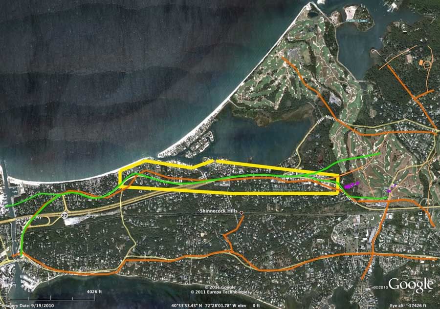
8.  Here is a overlay showing (among other things) the routes in question on the 1907 plan as well as the later 1916 Atlas.   The 1907 plan is in green, and the 1916 Atlas is in orange.   The 1907 Atlas looks like it approximates the 1916 highway.    We are talking about the same roads here.   And they run right up the gut of your first proposed site, which is yellow.


_____________________________________________
« Last Edit: March 23, 2011, 11:19:25 PM by DMoriarty »
Golf history can be quite interesting if you just let your favorite legends go and allow the truth to take you where it will.
--Tom MacWood (1958-2012)

DMoriarty

  • Karma: +0/-0
Re: The Creation of NGLA in Chronological, Contemporaneous News Articles
« Reply #1086 on: March 23, 2011, 05:13:12 PM »
Here is the same map more of the roads.


Blue - 1903 map.
Red - 1904 map.
Green - 1907 land plan.
Orange - 1916 map.
Purple - Shinnecock Inn (from 1907 land plan)

Yellow Box - Mike's mystery third site.
White Box - Mike's mystery fourth site.

While not shown, the highway on the 1907 Road Atlas seems to track the 1907 land plan and the 1916 Map.   And as you can see, while there is some variance from map to map (I don't think any of them are perfect) the roads generally track each other.  

The older roads (1903 and 1904) are missing the very first section of the northern road near the canal, and one section of the northern road from about the middle of Mike's third site east  

_____________________________

Bryan,

I hope this answers your question for a while ago.

_______________________________

Jeff Brauer,  

In the upper right hand corner is a small orange box next to a road with a circular driveway.  That is CBM's house on the 1916 Map.

____________________

NOW CAN WE PLEASE PUT TO REST THIS NONSENSE ABOUT THE ROADS AS WELL AS THIS NONSENSE ABOUT A THIRD AND FOURTH MYSTERY SITE?
« Last Edit: March 23, 2011, 11:20:14 PM by DMoriarty »
Golf history can be quite interesting if you just let your favorite legends go and allow the truth to take you where it will.
--Tom MacWood (1958-2012)

Patrick_Mucci

Re: The Creation of NGLA in Chronological, Contemporaneous News Articles
« Reply #1087 on: March 23, 2011, 06:08:53 PM »
Mike,

Would you read, with great care, the 1906-07 advertisements for the Shinnecock Inn and the Shinnecock Hills development.
Please pay special attention to the sections reporting on the roads in the area.


Please also note the auto in this add which appeared in a June 2, 1907 NY paper.

Why would they show people traveling to Shinnecock Hills in cars if no suitable roads existed.
Why would they state, in unequivical terms that good roads were in place ?

You've long ago entered the realm of "stupid" stubborn. ;D

Patrick_Mucci

Re: The Creation of NGLA in Chronological, Contemporaneous News Articles
« Reply #1088 on: March 23, 2011, 06:11:48 PM »
Mike,

Would you read, with great care, the 1906-07 advertisements for the Shinnecock Inn and the Shinnecock Hills development.
Please pay special attention to the sections reporting on the roads in the area.


Please also note the auto in this add which appeared in a June 2, 1907 NY paper.

Why would they show people traveling to Shinnecock Hills in cars if no suitable roads existed.
Why would they state, in unequivical terms that a
COMPLETE SYSTEM OF GOOD ROADS were in place ?

You've long ago entered the realm of "stupid" stubborn. ;D
« Last Edit: March 23, 2011, 09:23:17 PM by Patrick_Mucci »

Bryan Izatt

  • Karma: +0/-0
Re: The Creation of NGLA in Chronological, Contemporaneous News Articles
« Reply #1089 on: March 24, 2011, 12:42:33 AM »
David,

Yes, that was what I was looking for.  When I get home on Friday I'd like to add the 1903 and 1904 North Highways that Patrick has touted.

For the record I don't agree with Mike's thesis that there was a mystery third site.  I also don't agree with Patrick's assertion that the North Highway was a major commercial artery in 1906.  I don't think the road issue is all that compelling in knocking down Mike's site.  What is compelling is that it doesn't stretch along Peconic Bay, nor does it skirt the LIRR.  And, the fact that we know of no other mention of a third site.


Bryan Izatt

  • Karma: +0/-0
Re: The Creation of NGLA in Chronological, Contemporaneous News Articles
« Reply #1090 on: March 24, 2011, 12:53:29 AM »
Patrick,

In the following exchange I was interested in Shinnecock Hills Golf Club in the time before there was an NGLA.There were only a handful of estates in the area in those days.  The Shinnecock Inn wasn't built yet.  There weren't really a lot of cars.  Before 1905 was all play on SH from members who were on extended sojourns away from the city?  Or on weekends?  Hard to see how SH could have survived in those days.

Quote
I wonder if you can tell me who the members of SH were in the late 1800's and early 1900's.  I assumed they were successful rich NYC business men. Did they play their golf mainly on weekends?  Weekdays?  What percentage would have taken the train out for the weekend of golf and to go to their summer homes.  Or do you think they did daily commutes from NYC by horse and carriage?  I am curious on how golf was played in those days.  No argument required, I'm just curious as to your views.  It surely must have been different that today where we jump in the car, play a round, have dinner at the club and then hop in the car and go home.

Even today, NGLA is a seasonal club.
As we type, the club is closed.
Like ANGC, Seminole and others, the season seems to dictate the level of activity.
I suspect that many had their estates located on the South Fork, where they would summer for the season.
Sabin would seem to be a reasonable example.
Others probably stayed at the Inns/Hotels for short or long durations.
And others probably drove and/or railed to the area for varying durations.
Others probably stayed as guests with fellow members, for a weekend, week, month, season.
Don't forget, the pace wasn't as frenetic as it is today.

Bryan Izatt

  • Karma: +0/-0
Re: The Creation of NGLA in Chronological, Contemporaneous News Articles
« Reply #1091 on: March 24, 2011, 01:00:39 AM »


To get off the roads and mystery third site thing, here's another question.  Did NGLA own the land (200 yards long by ?? wide) between the original first tee and the Shinnecock Inn?  Back in 1906/7?  Today?  In between?  Or did they have a right of way on Peconic Realty land?  There's nothing obvious on the 1907 land plan. 


Bryan Izatt

  • Karma: +0/-0
Re: The Creation of NGLA in Chronological, Contemporaneous News Articles
« Reply #1092 on: March 24, 2011, 01:14:13 AM »
Patrick,

I know you are enamored of these ads.  I have forgotten what dates they are from.  Could you remind me.  The top one says the new roads were built by Peconic Bay Realty, yet they are only proposed roads in the 1907 land plan.  It also says there is no grade crossing between the Inn and Southampton.  How is that possible since the Inn is north of the tracks and Southampton is south.  Do you suppose there was some hyping going on in the ad?

The third one reads like a promo for a new development.  I suspect that all the promised amenities, includng the roads, are futures.  Nice picture with the windmill in the background.  Did the NGLA windmill exist at the time?

Mike,

Would you read, with great care, the 1906-07 advertisements for the Shinnecock Inn and the Shinnecock Hills development.
Please pay special attention to the sections reporting on the roads in the area.


Please also note the auto in this add which appeared in a June 2, 1907 NY paper.

Why would they show people traveling to Shinnecock Hills in cars if no suitable roads existed.
Why would they state, in unequivical terms that a
COMPLETE SYSTEM OF GOOD ROADS were in place ?

You've long ago entered the realm of "stupid" stubborn. ;D

Bryan Izatt

  • Karma: +0/-0
Re: The Creation of NGLA in Chronological, Contemporaneous News Articles
« Reply #1093 on: March 24, 2011, 01:17:45 AM »


I was looking at George's book in the Old Mac clubhouse today and saw the original blueprint of the course.  At a glance, it struck me that the shape of the property looked like a mirror image of the shape of The Old Course property.  Could CBM's routing have been inspired by the routing of TOC?


Mike Cirba

Re: The Creation of NGLA in Chronological, Contemporaneous News Articles
« Reply #1094 on: March 24, 2011, 09:53:46 AM »
Guys,

I'm not suggesting that this was some mystery "third site".    I'm suggesting it was the "Canal Site", that CBM's offer for that site happened in 1906, not 1905, and I'll try to explain more later as time permits.

I may be wrong, but I'd like to explain my thinking without this thing getting inflamed again.

This whole October article discussion is largely tangential to my larger points that I think are evidenced on this thread, and ironically, the viewpoint espoused by largely everyone else besides me here simply extends the design phase of the project over two months so I really don't mind if I am wrong.

Still, I'd like to make the case for it and would be happy to take constructive criticism.  

Please just don't tell me that barely travelled dirt roads running through the area in 1906 were going to be an impediment to building a golf course anywhere that CBM and Alvord agreed was desirable because that's preposterous.


David,

Thanks for taking the time to do all that drawing.

I do think it's important to note that the North Highway was never drawn as on the Olmstead Plan, especially that part near Shinny and NGLA.

As drawn on his Land Plan, he had the highway going along the north boundary of Shinnecock Hills, and when the actual highway was built, it went south of Shinnecock Hills, down along the tracks.

And I agree with your larger point that much of the Olmstead Plan in 1907 was accomplished over the decades since, but I really don't think they have much to do with what land was available to build a golf course on in 1906.

« Last Edit: March 24, 2011, 09:57:56 AM by MCirba »

Bryan Izatt

  • Karma: +0/-0
Re: The Creation of NGLA in Chronological, Contemporaneous News Articles
« Reply #1095 on: March 24, 2011, 01:01:29 PM »


Seems unlikely that it was the canal site.  Where you've drawn it is not near the canal.  And it's plausible that the 250 acres really meant 205 acres or even 450 acres.  But no transposition gets you to 120 acres.  If roads were not an issue, as I believe for the most part they weren't, then there are lots of 120 acre parcels near the canal that could have been what CBM had in mind.  By the way, the yellow area you originally created was 260 acres more or less.  You'll need to reduce its size by half if you want to match it up to CBM's 120 acres. 

But all of this has been said before.  What's your new thinking.


JESII

  • Karma: +0/-0
Re: The Creation of NGLA in Chronological, Contemporaneous News Articles
« Reply #1096 on: March 24, 2011, 01:04:02 PM »
Plus...it said "PURCHASED"!

Mike Cirba

Re: The Creation of NGLA in Chronological, Contemporaneous News Articles
« Reply #1097 on: March 24, 2011, 02:15:26 PM »
Jim,

What said "purchased"?   Are you referring to the October articles?

JESII

  • Karma: +0/-0
Re: The Creation of NGLA in Chronological, Contemporaneous News Articles
« Reply #1098 on: March 24, 2011, 02:19:31 PM »
Yep

DMoriarty

  • Karma: +0/-0
Re: The Creation of NGLA in Chronological, Contemporaneous News Articles
« Reply #1099 on: March 24, 2011, 03:45:18 PM »
David,

Yes, that was what I was looking for. When I get home on Friday I'd like to add the 1903 and 1904 North Highways that Patrick has touted.

I've done that.  The roads from these years are in blue (1903) and in red (1904) on the second map I posted.  I can make it bigger when you get back if you want.  I haven't posted the older maps which show a road through that area because I don't think they are anywhere near to scale.  

Out of curiosity I also looked at the 1907 land plan compared to newer land records, and it looks as if the vast majority of the roads on that plan were built.  Not sure if it was all in 1905-1907, but there are a number of articles indicating that the developer had invested substantially in developing this land but building a network of roads and such.  All that may have stopped abruptly with the bank panic in the fall of 1907 but by that point the project had been going for about two years.  But prior to that they had apparently been quite busy.  On July 13 1907 reported that development began shortly after the purchase and that the developer had  had built "a fine Hotel called the Shinnecock Inn, several miles of roads, two railroad stations, and three undergrade crossings."

Quote
In the following exchange I was interested in Shinnecock Hills Golf Club in the time before there was an NGLA.There were only a handful of estates in the area in those days.  The Shinnecock Inn wasn't built yet.  There weren't really a lot of cars.  Before 1905 was all play on SH from members who were on extended sojourns away from the city?  Or on weekends?  Hard to see how SH could have survived in those days.

I think you may be drastically underestimating how busy this place was during the summer.  Reportedly, even before the turn of the century this had become a premier summer locale for a Society, along with Newport. There were other summer clubs besides SHGC including the Hampton, Meadow, and Maidstone Club.   In addition to being an equity club, SHGC provided many summer memberships.  Tennis was big and so were "automobiling," fishing, and bicycling.  

My impression was that many had summer residences there and many others traveled there and stayed Inns or in rental cottages.   In 1898 there were reportedly five hotels or boarding houses in Southampton, twelve more in Good Ground.  In 1908 there were reportedly over 200 guest rooms in Southampton and "Golf Ground" and over 600 in Good Ground.  There was also a famous art colony and even a museum (Created by Samuel Parrish one of the founders of SHGC.)   Plus, some people did live out there, even back then.  I think I read that the population of Southampton was around 2000 in 1902 and the population of Sag Harbor was 3000 around the same time, but I will have to double check.

Here are a few photos from a 1908 RR promotional:
 

We aren't dealing with the boondocks here.  Just how many of such such summer cottages and clubs would have to been located out there for you to consider it civilized enough to have decent roads?  

Seriously, while there were undoubtedly some primitive roads out there, I really doubt they were all primitive.  I suspect that the roads had been improving as the automobile was becoming more prominent.  Those society types at these clubs were not riding around in horse buggies in 1905.  Rather, "automobiling" was quite a fad of the society crowd.  The Automobile Club of America and other such clubs had their origins as society social clubs, and families such as the Vanderbilts were big supporters.    The Shinnecock Inn was a frequent stop and/or destination for various automobile races and runs, and provided the "Shinnecock Inn Cup" for one such race in May of 1907.  

I came across a 1907 advertisement for an automobile which supposedly could make it from Brooklyn to the Shinnecock Inn faster the the "Cannon Ball Express " train between the two locations.  

Granted, all of this progress may all have been stalled or even set back by the bank Panic of 1907, but things were looking pretty rosy before then.
_________________________________

As for those ads you asked about, the first one was from the 1907 Automotive Blue Book, the second from newspapers in the spring of 1907.  

Patrick has mentioned that NGLA did not originally own the land between the course and Inn, and that they purchased some of that land later.  I don't know one way or another.
« Last Edit: March 24, 2011, 03:47:26 PM by DMoriarty »
Golf history can be quite interesting if you just let your favorite legends go and allow the truth to take you where it will.
--Tom MacWood (1958-2012)

Tags:
Tags:

An Error Has Occurred!

Call to undefined function theme_linktree()
Back