News:

This discussion group is best enjoyed using Google Chrome, Firefox or Safari.


TEPaul

Re: My attempt at the Timeline
« Reply #150 on: May 14, 2009, 05:59:15 PM »
"Tom,

Has the east boundary of the triangle changed since the 1910 Land Plan?

If yes, how so?"


Yes it has. I believe a very narrow and probably long triangle was carved off the Haverford College ground down along the left side of #16 in 1928. I believe this was to create a bit more width on the tee shot on #16. The amount of land of that triangle transfer was 403/1000th of an acre or is that too INEXACT for you guys?  ;)

DMoriarty

  • Karma: +0/-0
Re: My attempt at the Timeline
« Reply #151 on: May 14, 2009, 06:05:07 PM »
Mike Cirba,

Your continued incredulity, mockery, and sarcasm not only take away from the conversation, but they have are quite annoying, especially when one considers that when you are sarcastic and incredulous you have also been wrong.

They measured from the middle of the road.   Instead of mocking this, why don't you call a surveyor and ask him. Or have Wayne or TEPaul interpret the metes and bounds for you.     I assure you I did not make it up.

As for east boundary, TEPaul writes that the carve out was very narrow, but at the the bottom Merion gained 80 ft. of land.  

TEPaul,  

Who said the road had moved?   I certainly didn't.   I said it was wider now than in 1913.   Are you seriously disputing this?

"I hope no one on here is going to claim the PRR plat maps are dimensionally wrong or there will be about a million people in Pennsylvania who live along those rail lines who are gonna be all kinds of ticked off!  Wink

The only one who has disputed the accuracy PRR plat maps was you, when you disputed my overlay which was created with the 1916 mat plat.

But again, no one I know of said the road moved.   I said it was a mistake to assume the eastern border of the course is the same now as then.  

Did you tell your friend that you were announcing his and wife's name on a public website along with the exact location of his beautiful house.   Seriously Tom, delete their names.

Will someone who TEPaul will listen to contact him and tell him to take their names off?

As for post 103, it is impossible to tell what it means without more information.   Speaking of which . . .

DOES THE CUYLER LETTER OR RELATED INFORMATION IMPLY OR CONFIRM THAT ON DECEMBER 19, 1910 THERE WAS A COURSE ALREADY PLAN, ALBEIT NOT ONE THAT WAS DEFINITELY FINALIZED.

This is a very simple and fundamental question.  Why is it that you will not answer?  

_____________________
Golf history can be quite interesting if you just let your favorite legends go and allow the truth to take you where it will.
--Tom MacWood (1958-2012)

TEPaul

Re: My attempt at the Timeline
« Reply #152 on: May 14, 2009, 06:07:14 PM »
By the way guys, Ardmore Ave in a land transfer in 1926 was 40 feet wide (and I'm quite sure it still is) and the top of Golf House Rd for the first 97 yards coming down from College Ave. is 13 paces wide which is just about the same (40 feet) as Ardmore Ave. From there it swings right pretty hard and goes around #15 green. From a point at the Merion border at the side of the road and walking directly accross the green to the West border of the old Haverford College land is right around a 100 yards.

Mike_Cirba

Re: My attempt at the Timeline
« Reply #153 on: May 14, 2009, 06:27:23 PM »
Tom, I just read Reply #103 and that must have somehow beat me to my agreement with Sully that it's a hell of a question why someone would go to Lloyd instead of Wilson about the land swap ... But I'm not sure it answers the question. Why would Francis go to Lloyd in 1911 about the land swap if at that time, Wilson was "the man"?  Logically, if I take Reply #103 as true, that means that Francis went to Lloyd because he was "the man" at the time of the land swap idea, and if that's the case, why is Hugh Wilson getting all the credit because the resolution appears to say that whatever plan was presented to the Board requred a land swap that required Lloyd to say "yes".


Shivas,

I answered this earlier.    Who would you go to if you wanted to discuss borrowing 30 yards of land in one place and giving it back in another to better fit in two planned holes but the guy who owned the property?

This is what I wrote earlier.,..

Jim/Shiv,

The reason Francis went to Lloyd at midnight is simply because Lloyd was the man in control of all of that land.

Also, I don't have it handy but I do have the 1910 census and if I recall correctly I believe Wilson at the time was living a bit further away than one would want to bike at midnight in March. 

Mike_Cirba

Re: My attempt at the Timeline
« Reply #154 on: May 14, 2009, 06:35:55 PM »
Mike Cirba,

They measured from the middle of the road.   Instead of mocking this, why don't you call a surveyor and ask him. Or have Wayne or TEPaul interpret the metes and bounds for you.     I assure you I did not make it up.

As for east boundary, TEPaul writes that the carve out was very narrow, but at the the bottom Merion gained 80 ft. of land.  


David,

Where did Francis write that this was based on a measurement from the middle of the road?   He was talking about the dimensions of the land they needed for the golf course...to fit both the 15th and 16th holes in place in a playable way and to solve the problem of the quarry.  That's the 130x190 they needed, sans roadway.

And you're right about the east boundary.  It is about 25 yards additional at the base. 

I just measured the base of the triangle again on Google Earth and today the base is approx. 155 yards. (although admittedly, it's probably wider if I add in half the road.  ;))

My prior measurement was done keeping a straight line down from the straight eastern edge of the land (starting at the left side of the 16th tee) as drawn on the 1910 Land Plan.
« Last Edit: May 14, 2009, 06:41:35 PM by MikeCirba »

Mike_Cirba

Re: My attempt at the Timeline
« Reply #155 on: May 14, 2009, 07:43:21 PM »
David,

Besides, the "moving east boundary" is a red herring and you know it.

Can you tell us what the width of the lower part of the triangle is in the 1913 Railroad Map, which also shows the golf holes, and which was obviously done after the Francis Land Swap?

How does it compare to the November 1910 Land Plan in terms of overall width?

You can even measure it from inside the road...no need to go out to the middle.


Do I need to blow it up so that everyone here can easily see that the base of the triangle is exactly 130 yards drawn to scale (EXACTLY what Richard Francis said they needed) and that the 1910 Land Plan is at most 95 yards drawn to scale, or about 73% what was needed?

Are you still going to argue that the November 1910 Land Plan had enough width to contain the holes that the Merion Committee wanted to build and eventually did, after they figured out how to reconfigure the road?

« Last Edit: May 14, 2009, 08:37:29 PM by MikeCirba »

DMoriarty

  • Karma: +0/-0
Re: My attempt at the Timeline
« Reply #156 on: May 14, 2009, 09:13:16 PM »

'Where did Francis write that this was based on a measurement from the middle of the road?   He was talking about the dimensions of the land they needed for the golf course...to fit both the 15th and 16th holes in place in a playable way and to solve the problem of the quarry.  That's the 130x190 they needed, sans roadway."

Mike Cirba,

NO.  He described the property for which they traded, it was 130 x 190 yds.  And the property for which they traded extended and extends to the MIDDLE OF THE ROAD.     

Ask TEPaul. I know he knows, because I told Wayne where he could find the document that spells it out.    Why do you suppose he keeps letting you fight these battles even though he knows you are wrong.? 

"My prior measurement was done keeping a straight line down from the straight eastern edge of the land (starting at the left side of the 16th tee) as drawn on the 1910 Land Plan."

This too is incorrect.  The boundary was around 10 or 15 yards east of the edge of the tees. 

"Besides, the "moving east boundary" is a red herring and you know it."

A red herring? That you simply drop your old argument and move on once proven wrong doesn't make the proof a red herring.

As for the 1913 RR map, take a look at my overlay which you trashed earlier.  It is based on the 1916 RR atlas which is also to scale.  As I said above, it is not a perfect match, but it is close.   

If you need more than that, do it yourself.

__________________________________________________________

Shivas.  It doesn't make sense to me either.   

1.  It doesnt make sense that he called Lloyd instead of Wilson if this was indeed near the end of their planning.  It would have impacted a number of holes and you'd think he would have included the "designer" if he was going to make that kind of change.   

2.  It doesn't make sense that Merion would give up "the land now covered by fine homes along Golf House Road" for the narrow piece  of land that Mike and Tom insist that Merion received in return. 

3.  It doesnt make sense that he is riding his bike around near midnight in March with the temperature very likely below 40 and quite possibly below 30.

There are quite few other and more important things that don't make sense, including one or two that would give us a definite answer one way or another, but we need a few more facts first.   The way I see it, we are only getting the facts that TEPaul thinks will convince us, and he is hiding everything else.  This is just convincing me that he needs to come clean.    Instead of playing the guessing game, I'd rather have the facts.   

Why do you suppose TEPaul won't answer my question regarding the existence of some sort of plan (although not yet definitely final) in 1910?   
Golf history can be quite interesting if you just let your favorite legends go and allow the truth to take you where it will.
--Tom MacWood (1958-2012)

Mike_Cirba

Re: My attempt at the Timeline
« Reply #157 on: May 14, 2009, 09:23:46 PM »
David,

The 1910 Scale Drawing Land Plan from the edge of the road to the right hand boundary is 90, 95 yards wide at best.

The 1913 Scale Drawing As Built Railroad map from the edge of the road to the right boundary is 130 yards, exactly what Francis described.

This isn't close.

It's not close by any reasonable measure.

Close is a few yards difference here or there...

Close is not 70% of the needed dimensions.

Close is not over 1/3 of a football field in width.

Close is not ten yards wider than the width of a US Open Fairway.

Close is not three and one half first downs.

You are so spiteful in your blind prejudice against Hugh Wilson that you're willing to give full credit as the architect to Francis and Lloyd, witness your post to Shivas.

Is it because he was Ivy League or something?

Tell us, what is this all about...

I swear if you could argue that Leroy Wilson laid out Merion instead of Hugh Wilson you would.

Why the anger against him?

p.s.  Of course the boundary was east of the tee on 16...do you think I'm suggesting the white stakes were atop it?...

That doesn't alter in the least the fact that the original dimenson was 130 yards at the base of the triangle and today it's 155 yards wide at the base of the triangle.

Those are the facts, and they are measurable and indisputable.

Just as the fact that the 1910 Land plan is no more than 95 yards wide.


« Last Edit: May 14, 2009, 09:34:28 PM by MikeCirba »

DMoriarty

  • Karma: +0/-0
Re: My attempt at the Timeline
« Reply #158 on: May 14, 2009, 09:33:25 PM »
Give it a rest Mike.

As I said in my first post to you, arguing this is a waste of time.  This is a factual question.  It can easily be determined by looking at the facts.

So how about it Tom?
Golf history can be quite interesting if you just let your favorite legends go and allow the truth to take you where it will.
--Tom MacWood (1958-2012)

Mike_Cirba

Re: My attempt at the Timeline
« Reply #159 on: May 14, 2009, 09:38:12 PM »
Give it a rest Mike.

As I said in my first post to you, arguing this is a waste of time.  This is a factual question.  It can easily be determined by looking at the facts.

So how about it Tom?

David,

The facts are that;

The 1910 Land Plan was 95 yards max at the base of the triangle, from inside the road to the eastern boundary.

The 1913 Railroad Map was 130 yards at the base of the triangle, from inside the road to the eastern boundary.

Today's course has been widened by 25 yards on the eastern boundary, making the total, factual, measureable distance 155 yards from inside the road to the eastern boundary.

If you disagree with these facts, please tell us the exact dimensions of each from inside the road to the eastern boundary in your estimation.

This is a factual question, David.   I'm not asking for your opinion or your interpretation of what Richard Francis said for the 185th time.

What are your measurements from the exact spots I've named above?

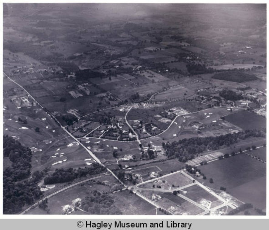
By the way, David, it isn't a "sliver of land" that they traded...it was almost 120 feet wide at it's widest point and ran for some of the 14th and most of the 15h holes, and can be seen represented in the following crude drawing.


Even in this 1924 aerial, you can already see where the "fine homes along Golf House Road" were located by the year 1950 when Francis was speaking, on land down along the 1st and 14th holes that was traded for land along the upper part of 14 and most of 15.


"Facts" are not your constant parsing and interpretation and twisting of words, David.   

These are the facts...they are viewable, and measurable, and time-lineable, and they don't lie.


p.s.   It seriously might be time for you to take a break from this, David....

Earlier today when it suited your argument you produced a graph showing that temps in the 1911 Winter/Spring were quite moderate, and now you tell us Francis couldn't have rode the 1 mile in March or April at midnight to Lloyd's house??

Which is it?   :-\

Where did Hugh Wilson live in 1911?   How far was it from Francis's house??   Who owned the land in question at that time???


« Last Edit: May 14, 2009, 10:04:01 PM by MikeCirba »

DMoriarty

  • Karma: +0/-0
Re: My attempt at the Timeline
« Reply #160 on: May 14, 2009, 10:04:49 PM »
Mike,  my measurements differ from yours on both maps.  I get between 130 and 135 on the 1913 Atlas, and around 110 to 120 to the center of the road.    As I said, the approximate location of the road was not a perfect fit, but I wouldn't expect it to be, given that it was only an APPROXIMATE LOCATION OF THE ROAD.

But either way.  Findlay is crystal clear on what the land for which he swapped.  The entire area.


"p.s.   It seriously might be time for you to take a break from this, David....

Earlier today when it suited your argument you produced a graph showing that temps in the 1911 Winter/Spring were quite moderate, and now you tell us Francis couldn't have rode the 1 mile in March or April at midnight to Lloyd's house??

Which is it?

Where did Hugh Wilson live in 1911?   How far was it from Francis's house??   Who owned the land in question at that time???"


1.  I did not produce a chart showing the temperatures were moderate.  I don't think they were and I don't think it is likely that he was out biking when when it was in the 20s or 30s.

2.  I went through where everyone lived before, but am tired of explaining things to you and will not dig it up.   You wouldn't believe me anyway. 

3.  I believe Hugh Wilson owned a phone. 
« Last Edit: May 14, 2009, 10:11:49 PM by DMoriarty »
Golf history can be quite interesting if you just let your favorite legends go and allow the truth to take you where it will.
--Tom MacWood (1958-2012)

JESII

  • Karma: +0/-0
Re: My attempt at the Timeline
« Reply #161 on: May 14, 2009, 10:13:41 PM »
What did Findlay say?

Mike_Cirba

Re: My attempt at the Timeline
« Reply #162 on: May 14, 2009, 10:31:50 PM »
David,

Given that it was indeed spring, and close to midnight, I would hope you'll excuse Mr. Francis for not riding all the way to Hugh Wilson's house in Radnor, which was either 5.5 or 6.1 miles away from Merion proper, depending on whether Wilson's residence was on the east or west side of Lancaster Avenue.

Besides, Wilson had two very young children, so even if Francis didn't recognize that it was midnight, I'm quite sure he was polite enough to know it was beyond calling time with the somewhat loud, awakening phone technology of the time on a school night.

And, please do share your 120 yards to the middle of the road on the 1910 map.   :o

I'm going to start calling you Reed Richards.... ;D

Unless of course you are working with a map beyond 1910, in which case it certainly must be very VERY cold outside because on those maps a better nickname might be the INcredible Shrinking Man.  ;)   ;D
« Last Edit: May 14, 2009, 10:43:08 PM by MikeCirba »

DMoriarty

  • Karma: +0/-0
Re: My attempt at the Timeline
« Reply #163 on: May 14, 2009, 10:38:04 PM »
Mike, I am done with your sarcasm and righteous indignation.   If you want to discuss anything further, grow up.


Jim,

Don't have time to track it down now, but will later if no one else will bother. 
« Last Edit: May 14, 2009, 10:40:13 PM by DMoriarty »
Golf history can be quite interesting if you just let your favorite legends go and allow the truth to take you where it will.
--Tom MacWood (1958-2012)

Mike_Cirba

Re: My attempt at the Timeline
« Reply #164 on: May 14, 2009, 10:42:07 PM »
Mike, I am done with your sarcasm and righteous indignation.   If you want to discuss anything further, grow up.


Jim,

Don't have time to track it down, now but will later if no one else will bother. 

David,

I second Sully's request for some additional info from Findlay. 

If you have other evidence, please produce it.   I'm more than willing to learn if you have something new of value.

The stuff you've put forward to date isn't cutting it, no matter how you try to minimalize, and dismiss, and ignore my pointed and factual responses.   Your interpretation of Francis's words is directly contradicted by the available evidence to date.

I'm sorry you feel I'm a harsh critic, but 90 versus 130 yards is enough to call it a Land Swap under any reasonable understanding during any time period.
« Last Edit: May 14, 2009, 10:45:50 PM by MikeCirba »

TEPaul

Re: My attempt at the Timeline
« Reply #165 on: May 14, 2009, 10:43:07 PM »
"I just measured the base of the triangle again on Google Earth and today the base is approx. 155 yards. (although admittedly, it's probably wider if I add in half the road.   ;))"


Mike Cirba:

That would be pretty close to right today. I just paced it off from the Merion land boundary behind #16 tee down the hole 190 yards. From there I stepped over to the left (east) where the 16th hole and the driving range create basically an OB (the 1928 land transfer long and narrow triangle). From there I walked straight west to the side of Club House Rd. That was 161 yards. If you stepped off to the middle of the road it would be 167 1/2 yards (the road is 40 feet wide). I walked it back the other way. Same yardage.

Now, that long and thin triangle that MCC carved off of the western boundary of the Haverford College land in 1928 probably is about 25-30 yards at the base of the triangle (190 yards down from behind #16 tee) just as Moriarty said and the 1928 deed metes and bounds I have articulate on the deed. Walking the deed metes and bounds and using the directional description of the metes and bounds from the SW corner of the old MacFadden property (today belonging to Van Arkle) that would be very close (I had a pocket compass with me and estimated the directional degrees on the title abstract metes and bounds directions as best as I could).

Net out that 1928 long and narrow triangle inclusion from the 1928 land transfer and you are very close to 130 yards wide at the base of that triangle that we assume is perpindicular to #15 and #16 and running east/west (the holes basically run north/south).

Now, considering all that does anyone really deny, at this point, that the Nov. 15, 1910 triangle in that proposed plan at that base even reached a width of 100 yards? If so that would seem to be a pretty flagrant and preposterous claim as a professional surveyor making a mistake in land calculation of over thirty five yards in a 100-130 yard run would be grounds for a future land dispute lawsuit or at least an immediate resurvey. And do I need to remind anyone that that would have been picked up immediately in a major land size discrepency when the multiple lot dimensions and title and deed and mortgage process went on when the lots were sold and transfered on the western side of Club House Rd over the next decade or so?

If anyone still thinks that Nov, 15, 1910 proposed land map that is in scale made a discrepency of that kind of dimension and degree I can sure guarantee them I no longer want to have any further discussions on here with them about the architectural creation of Merion East in 1910 and 1911!

I believe what we have finally offered on here is some of the most accurate and detailed dimensional evidence ever asked for and provided in the history of GOLFCLUBATLAS.com for a golf course that is very close to a century old and that had some pretty interesting border adjustments from its initial inception until today.
« Last Edit: May 14, 2009, 11:04:02 PM by TEPaul »

Mike_Cirba

Re: My attempt at the Timeline
« Reply #166 on: May 14, 2009, 10:51:36 PM »
And by the way, David...the term "Approximate Location of Road" refers to the fact that it wasn't built yet.

However, it doesn't refer to the clear land boundaries on that Scale Map that had been laid out by November 15, 1910.

It's CRYSTAL clear, even in the different color coding, to recognize the actual physical dimensions of the land designated and titled "Haverford Development Company" and "Merion Golf Course", respectively.


This was a legal document representing a potential real-estate sales opportunity and offer to the membership.   

It's why they hired a legally qualifed surveyor in the first place to produce it.

This could be entered in a court of law as fraudulent if it wasn't accurate and you know it.


« Last Edit: May 14, 2009, 10:56:32 PM by MikeCirba »

TEPaul

Re: My attempt at the Timeline
« Reply #167 on: May 14, 2009, 11:16:27 PM »
"Can you tell us what the width of the lower part of the triangle is in the 1913 Railroad Map, which also shows the golf holes, and which was obviously done after the Francis Land Swap?"


I can because I measured that 1913 PRR plat map today that is in scale. The base of the triangle on the 1913 PRR plat map measures out to around 130 yards in 1913 (after the course was built)---the very same triangle base dimension we scaled from the Francis land swap addition off the Nov. 15, 1910 proposed land plan that Francis's story explained thirty nine years later ADDED to the base of that less than 100 yard wide IN SCALE measurement off that Nov 15, 1910 plan to create a base of 130 yards that essentially solved the narrowness problem with the 15th green and 16th tee which was the essential solution of the Francis land swap idea.

But we need to add app. 25-30 yards to the base of that triangle TODAY as it now INCLUDES the land that MCC picked up when they bought that narrow and long triangle off the western border of the Haverford College land in 1928.

And that is exactly WHY when I walked that base of the old triangle both ways today I came out with that triangle base measurment of app. 160 yards! ;)
« Last Edit: May 14, 2009, 11:19:45 PM by TEPaul »

TEPaul

Re: My attempt at the Timeline
« Reply #168 on: May 14, 2009, 11:57:56 PM »
"Shivas.  It doesn't make sense to me either.   

2.  It doesn't make sense that Merion would give up "the land now covered by fine homes along Golf House Road" for the narrow piece  of land that Mike and Tom insist that Merion received in return."


David Moriarty:

I spent a couple of hours today walking off the entire north to south delineation of Golf House Road from College Ave on the north to Ardmore Ave on the south measuring east to west at about 10-12 different points along the entire run of that road. The land covered by fine homes runs the entire length of that road as was the case when Francis wrote his story in 1950. They picked some up and gave some back in the Francis Land swap idea in 1911 all the way from College Ave on the north to Ardmore Ave on the south compared to that Nov. 15, 1910 proposed plan which was about two years before that road was actually built and the ENTIRE thing created a NET land swap with the golf course and the residential development to the west. That's precisely what the Thompson resolution at the board meeting on April 19, 1911 approved and CREATED the way the road runs today between the course and the beautiful houses on the western side of Club House Road ALL THE WAY from College Ave. on the north to Ardmore Ave on the south.


"There are quite few other and more important things that don't make sense, including one or two that would give us a definite answer one way or another, but we need a few more facts first.   The way I see it, we are only getting the facts that TEPaul thinks will convince us, and he is hiding everything else.  This is just convincing me that he needs to come clean.    Instead of playing the guessing game, I'd rather have the facts.   

Why do you suppose TEPaul won't answer my question regarding the existence of some sort of plan (although not yet definitely final) in 1910?"


Why do you suppose I won't answer you questions Moriarty? As I've told you FOUR TIMES now ON THIS THREAD, go back and read posts #41 and #52 on this thread and do as I ask you to do on those threads if you want me to even consider cooperating with you on what you're asking me for.

Do that and you may sniff some satisfaction. If not you can just forget about it. If you don't do that and you really want to know why I'm not going to consider cooperating with you unless you do that I will probably tell you why even though I have been trying very hard to be as civil with you on here as I can possibly be. Or you might try thinking about WHY you are the ONLY person on here who has EVER made these kinds of demands for private club information while all the time insulting the research, the research ethic and the research dedication and the intelligence of the people you are asking for it.
« Last Edit: May 15, 2009, 12:05:25 AM by TEPaul »

DMoriarty

  • Karma: +0/-0
Re: My attempt at the Timeline
« Reply #169 on: May 15, 2009, 12:35:11 AM »
Jim,  Here is the excerpt from Merion's book, in its entirety:

"Except for many hours over a drawing board, running instruments in the field and just plain talking, I made but one important contribution to the layout of the course.

The land was shaped like a capital "L" and it was not very difficult to get the first 13 holes into the upright portion - with the help of a little ground on the north side of Ardmore Avenue - but the fast five holes were another question.

I was looking at a map of the property one night when I had an idea.  Not realizing it was nearly midnight, I called Mr. Lloyd on the telephone, found he had not gone to bed, got on my bicycle and rode a mile or so to see him.  The idea was this:  We had some property west of the present course which did not fit in at all with any golf layout, perhaps we could swap for some we could use? 

Mr. Lloyd agreed.  The land now covered by fine homes along Golf House Road was exchanged for land about 130 yards wide by 190 yards long - the present location of the 15th green and the 16th tee.  Within a day or two, the quarryman had his drills up the hill so that the green could be built as it is today."


A few quick comments:

-The description of the land Merion received in the swap is well defined:  The land now covered by fine homes along Golf House Road was exchanged for land about 130 yards wide by 190 yards long - the present location of the 15th green and the 16th tee.

-Something I had forgotten in all the noise:   He wasn't looking over multiple plans, he was "looking at a map of the property."

-Notice that Francis only mentioned adding land in this corner, and did not mention adding land almost all the way back to the clubhouse, as Mike's squiggly green line indicates.

Hope this helps.

___________________________________________________________

TEPaul,

I am glad you enjoyed your walk, but we have known for a long time that the width measured about 130 yards when the course opened.  Francis tells us so.   And I measured this for you a about a year ago after you insisted that it was actually much wider than that.  Your original theory was that 130 yards was added on top of what was already there.  Remember?  And I told Mike that it had been moved over 25 yards (26 1/3 actually.)   You do know how Wayne came to possess that deed, don't you?

"Now, considering all that does anyone really deny, at this point, that the Nov. 15, 1910 triangle in that proposed plan at that base even reached a width of 100 yards? If so that would seem to be a pretty flagrant and preposterous claim as a professional surveyor making a mistake in land calculation of over thirty five yards in a 100-130 yard run would be grounds for a future land dispute lawsuit or at least an immediate resurvey. And do I need to remind anyone that that would have been picked up immediately in a major land size discrepency when the multiple lot dimensions and title and deed and mortgage process went on when the lots were sold and transfered on the western side of Club House Rd over the next decade or so?

If anyone still thinks that Nov, 15, 1910 proposed land map that is in scale made a discrepency of that kind of dimension and degree I can sure guarantee them I no longer want to have any further discussions on here with them about the architectural creation of Merion East in 1910 and 1911!"


Just so we all understand you . . .

1.  You insist that the road marked "APPROXIMATE LOCATION OF THE ROAD" was not the approximate location but was the exact location.

2.  You insist that all Merion accomplished by the Francis Land Swap was to expand this area in the corner from somewhere between 95 and 120 yards (or whatever the 1910 map shows) at its widest to 130 yards at its widest.

3. You insist that if I or anyone else does not accept the above two points as true then you will no long have "any further discussions on here with them about the architectural history of Merion East in 1910 and 1911!"

Do I understand you correctly here?   
« Last Edit: May 15, 2009, 12:53:39 AM by DMoriarty »
Golf history can be quite interesting if you just let your favorite legends go and allow the truth to take you where it will.
--Tom MacWood (1958-2012)

DMoriarty

  • Karma: +0/-0
Re: My attempt at the Timeline
« Reply #170 on: May 15, 2009, 12:46:47 AM »
TEPaul, you must have missed my previous response:

Again Tom, I think we need to clarify here.  I haven't made any demands of Merion or MCC.  I have made demands of those who have ceaselessly attacked my essay, my intelligence, and my character for the past year or more, yet have refused to back up their attacks with the facts they claim exist.  That isn't Merion or MCC.  That'd be Wayne, you, and Mike Cirba.   And while you may be friend of Merion, and Wayne is a member, my demands are only of those of you who have talked the talk for a year, but have thus far refused to walk the walk.

My demands are for nothing more than what the most basic civil discussion requires.  You came after me with claim after claim, insult after insult, and now it is my turn to vet and answer your claims, or vet and accept them, but either way vetting them has to be part of the process.   

As to why I am the only one making these demands of you guys, can you think of anyone else (other that MacWood) who you have constantly attacked  for over a year based on mysterious source material that only you were allowed to see?  I can't.

I don't think I ever asked Merion for a thing prior to my essay.  I don't think I ever demanded a thing from you guys until after you guys started using the material to undermine my essay and my character.   

Imagine if I got access to someone's old diary, like Hugh Wilson's, and claimed the person who gave me access was very private and didnt want the information out there.   But then went ahead and cherry-picked tidbits out of the diary to attack your positions and to build up my own.  Not only that but imagine I also used the information to repeatedly attack and insult you, your character, and your intelligence.  What would your response be?   Somehow I doubt you would simply take what I was telling you at face value.  I also have a feeling you'd demand that I back up my claims.

___________________

Now, can you tell me if I got your latest ultimatum right in my post above?

1.  You insist that the road marked "APPROXIMATE LOCATION OF THE ROAD" was not the approximate location but was the exact location.

2.  You insist that all Merion accomplished by the Francis Land Swap was to expand this area in the corner from somewhere between 95 and 120 yards (or whatever the 1910 map shows) at its widest to 130 yards at its widest.

3. You insist that if I or anyone else does not accept the above two points as true then you will no long have "any further discussions on here with them about the architectural history of Merion East in 1910 and 1911!"

Did I get it right?
« Last Edit: May 15, 2009, 12:48:55 AM by DMoriarty »
Golf history can be quite interesting if you just let your favorite legends go and allow the truth to take you where it will.
--Tom MacWood (1958-2012)

Bryan Izatt

  • Karma: +0/-0
Re: My attempt at the Timeline
« Reply #171 on: May 15, 2009, 01:28:29 AM »
David,

With all respect to Bryan Izatt for his attempt at the overlay, and to your own, they are crude, inaccurate, and misrepresentative.

.............................


With all respect (I hope you weren't trying to be sarcastic when you said that), Mike, my overlay was neither crude, inaccurate nor misrepresentative.  Following is a clearer overlay using your 1910 map.  It needed some massaging to account for the photographic distortion.  What it clearly shows is that holes 15 and 16 as presently laid out come very close to fitting in the triangular piece of land on the 1910 map.  The white line ending with red dots is 130 yards on the Google Earth map.  I'd estimate the 1910 width at 100 yards.  Clearly as much of the increase to the current width (155 yards from the margin of the road to the middle of the tree line) comes from the east side of the property as comes from the west side.

It also shows that the land ceded to HDC by the bowing of the road near the clubhouse was significant while any land added to Merion near the 15th and 16th was relatively smaller. A good trade for HDC if there were no other financial considerations.

Whether Francis meant to say that the "land now covered by fine homes along Golf House Road" was exchanged for a small extra sliver for the triangle as you and Tom assert, or "was exchanged for land about 130 yards wide by 190 yards long" in its entirety, as stated in Merion's book, I can't say.  It's conceivable he was misquoted, or he misstated it, or that he stated it correctly and was quoted correctly.

It's said that Francis "was looking at a map of the property one night when I had an idea."  What map do you suppose he was looking at?  The 11-15-10 one?  Do you suppose he was drawing fairway corridors, greens and tees on it?  How do you suppose he knew that they needed some additional sliver of land up there? 


« Last Edit: May 15, 2009, 02:40:54 AM by Bryan Izatt »

TEPaul

Re: My attempt at the Timeline
« Reply #172 on: May 15, 2009, 02:05:59 AM »
"With all respect (I hope you weren't trying to be sarcastic when you said that), Mike, my overlay was neither crude, inaccurate nor misrepresentative.  Following is a clearer overlay using your 1910 map.  It needed some massaging to account for the photographic distortion.  What it clearly shows is that holes 15 and 16 as presently laid out come very close to fitting in the triangular piece of land on the 1910 map.  The white line ending with red dots is 130 yards on the Google Earth map."


Bryan Izatt:

What in the Christ are you doing? Why don't you just start by getting ALL the source material in your possession as we have and start by accurately analyzing a couple of professional survey maps that are IN SCALE and totally MEASURABLE to pretty exact dimensions?

Secondly, did you even notice you have that red dot on the left of the 16th on that white line about 15 YARDS inside the Haverford College property lines AND you have the underlay of the golf course shifted so far TO THE EAST we can only see about six feet of the GOD-DAMNED 16th tee??? I just walked that very area accross the 16th tee today and there is about 20+ more yards of the golf course to the east of the way you have that ridiculous mapquest or Izatt overlay or undelay set up.

Do us all a favor and start by accurately measuring ALL the dimensions of that Nov. 15, 1910 plan FIRST and then measuring what's on the ground today as I did because I can guarantee you there is nothing that has changed out there from 1911 other than that 1928 land transfer with Haverford College and MCC in 1928 I mentioned just above.

My God you amateur architectural analyzers who are not from around here and who don't understand this club's and course's entire detailed evolutinary history are a bunch of brainfarts!

AND, by the way, Bryan, the guy's name is not FINDLAY, it's RICHARD FRANCIS. In case you're not aware of it, at this point, the architect of Merion East was HUGH I. WILSON and not CHARLES BLAIR MACDONALD!  :P
« Last Edit: May 15, 2009, 02:21:39 AM by TEPaul »

Bryan Izatt

  • Karma: +0/-0
Re: My attempt at the Timeline
« Reply #173 on: May 15, 2009, 03:47:31 AM »
Sheesh, Tom, you're a little hyper for this time of the night.   :o

"With all respect (I hope you weren't trying to be sarcastic when you said that), Mike, my overlay was neither crude, inaccurate nor misrepresentative.  Following is a clearer overlay using your 1910 map.  It needed some massaging to account for the photographic distortion.  What it clearly shows is that holes 15 and 16 as presently laid out come very close to fitting in the triangular piece of land on the 1910 map.  The white line ending with red dots is 130 yards on the Google Earth map."


Bryan Izatt:

If you have an better electronic version of the 1910 map, I'd be happy to use it.  Mike's map is admittedly distorted.

Secondly, did you even notice you have that red dot on the left of the 16th on that white line about 15 YARDS inside the Haverford College property lines (Yes, I did notice that.  What's your point?  Does the current course not extend a little to the east of the old Haverford College property line on the 1910 map?  A few posts back you said that Merion added land on the east side, a "triangle transfer was 403/1000th of an acre" in 1928.  Are you suggesting that whatever triangle was added there was all east of the tee blocks?)  AND you have the underlay of the golf course shifted so far TO THE EAST we can only see about six feet of the GOD-DAMNED 16th tee??? I just walked that very area accross the 16th tee today and there is about 20+ more yards of the golf course to the east of the way you have that ridiculous mapquest or Izatt overlay or undelay set up.  Could you describe where on the current Google map the original 1910 property line was, and where the current property line is.  Is the tree line on the current property line?  The 1928 property line? I'm a little confused about where you're saying there is 20+ more yards to the east of the 16th tee. As a point of reference, there appears to currently be a small building associated with the driving range that's about 8 yards east of the edge of the 16th tee. Where is the 20 yards relative to that, or is it more down near the bginning of the 16th fairway? The current tree line curves to the east, while the 1910 map show a straight property line.


Do us all a favor and start by accurately measuring ALL the dimensions of that Nov. 15, 1910 plan FIRST and then measuring what's on the ground today as I did because I can guarantee you there is nothing that has changed out there from 1911 other than that 1928 land transfer with Haverford College and MCC in 1928 I mentioned just above.  Hmmm, I thought everybody more or less agreed that the edge of the road to the property line is around 95 to 100 yards on the 1910 map. As I asked above, if you could locate where you think the 1910 and 1928 property lines on the east side are on the Google map, that might  help move the discussion along. Also. are you saying that nothing on the location and size of the 16th tee and 15th green has changed since 1911?

My God you amateur architectural analyzers who are not from around here and who don't understand this club's and course's entire detailed evolutinary history are a bunch of brainfarts!  I didn't notice that I was doing any amateur architectural analysis.  I was merely trying to provide a reasonable mapping of the current course on the 1910 plan.  Perhaps you mistook me for Moriarty.  In any case, the "brainfarts" comment is a little over the top, don't you think?

AND, by the way, Bryan, the guy's name is not FINDLAY, it's RICHARD FRANCIS. Of course.  It was late.  Duly noted and corrected.  In case you're not aware of it, at this point, the architect of Merion East was HUGH I. WILSON and not CHARLES BLAIR MACDONALD!  :P  Not everyone out here is Moriarty, you know.  I never said or implied that CBM was the architect for Merion.   ???

Mike_Cirba

Re: My attempt at the Timeline
« Reply #174 on: May 15, 2009, 07:00:39 AM »
Bryan,

Thanks for that map.   It's much more clear and I meant nothing sinister in my original comment about the other being misleading.   The lines on it were too thick to see much, frankly.   Although honestly, this map would make more sense if you showed the course overflowing on the western side because it's difficult to see how much of the course simply falls off the map on the right.   If you need someone to point out the original east property line on the modern aerial I can try to do that later.

As far as which map Francis might have been using, he tells us that he spent many hours out surveying in the field, so I'm quite sure it was a topographical map they created for the purpose, and which Wilson mentioned in a letter in February 1911 to Piper.

Also, that map would have had the exact same property dimensions as what had been originally purchased by Lloyd n December 1910, and also those exact property dimensions that show up on the November map.

He tells us that the land they gave up along Golf House Road did not fit in with ANY golf plans, so we know there was more than one routing or plan being considered at that time.

He tells us that the first 13 holes were already routed.

I'm sure they probably drew sticks on proposed 15 & 16, as well, but once they actually tried putting them on the ground it became quickly apparent that you couldn't play around 16 (as most members certainly had to do on a 430 yard par four full-carry second with hickory...perhaps David tried this himself when he played Merion?) up the right side if you had the 15th hole there.

So, like a jigsaw puzzle, they needed a bigger piece to get in those holes.

If you look at the land they had available after they located the first 13, it makes absolutely no sense that they thought they had enough land left for the last five holes if they only purchased land just beyond the quarry in the first place.   The only other place land could have been would be left of 1 & 14 and we already know that land was not part of any golf plan.

Where do you think they might have been thinking of locating the last five holes if they didn't have at least some of that triangle purchased already??

Anyone??

Let's do a routing exercise.

David...what you you think??   I'd love to see how you think they would have considered that they could get five holes in that stretch.
« Last Edit: May 15, 2009, 07:02:39 AM by MikeCirba »

Tags:
Tags:

An Error Has Occurred!

Call to undefined function theme_linktree()
Back