News:

This discussion group is best enjoyed using Google Chrome, Firefox or Safari.


Mike_Cirba

Re: The Merion Timeline - Stick A Fork In It!
« Reply #1700 on: June 18, 2009, 06:14:31 PM »
Pat,

There are multiple pics of the original dogleg left 1st hole that hugged GHR and whose green overlaps today's current green as well.

Neither hole can fit into the dimensions of the 1910 Land Plan which is getting to be a redundant statement.

The only difference here being that with todays hole, only a large chunk of green and beyond wouldn't fit...about 50 yards.

On the original 1st hole, a large hunk of fairway as well as the green wouldn't fit.

Patrick_Mucci

Re: The Merion Timeline - Stick A Fork In It!
« Reply #1701 on: June 18, 2009, 08:18:40 PM »
Mike,

Have you seen the Cuyler letter in its entirety ?

Mike_Cirba

Re: The Merion Timeline - Stick A Fork In It!
« Reply #1702 on: June 18, 2009, 08:25:25 PM »
Patrick,

No, only what I've read of it here that Tom Paul relayed over a year ago.


Doug Braunsdorf

  • Karma: +0/-0
Re: The Merion Timeline - Stick A Fork In It!
« Reply #1703 on: June 18, 2009, 08:44:05 PM »
Mike,

  Is there a way the Cuyler letter can be reproduced in its entirety and shared here? 
"Never approach a bull from the front, a horse from the rear, or a fool from any direction."

Jeff_Brauer

  • Karma: +0/-0
Re: The Merion Timeline - Stick A Fork In It!
« Reply #1704 on: June 18, 2009, 08:45:05 PM »
Mike,

But to recap the letter, which I believe TePaul paraprhased or even quoted sometime in one of these threads, it was dated Dec. 10, 1910, it recommended that HDC take the land in Lloyd's name, and it said Lloyd had complete power to move boundaries around for the benefit of both MCC and HDC.  It also urges them to let him know when the boundaries are finalized.

Is that a correct summary?

If it is, then your contention is that it proves that the routing wasn't complete, and as per most MCC records, hadn't probably even started, is that correct?
Jeff Brauer, ASGCA Director of Outreach

Mike_Cirba

Re: The Merion Timeline - Stick A Fork In It!
« Reply #1705 on: June 18, 2009, 09:45:42 PM »
Mike,

But to recap the letter, which I believe TePaul paraprhased or even quoted sometime in one of these threads, it was dated Dec. 10, 1910, it recommended that HDC take the land in Lloyd's name, and it said Lloyd had complete power to move boundaries around for the benefit of both MCC and HDC.  It also urges them to let him know when the boundaries are finalized.

Is that a correct summary?

If it is, then your contention is that it proves that the routing wasn't complete, and as per most MCC records, hadn't probably even started, is that correct?

Doug,

Since the two guys who found the letter are no longer here, I'd say it's pretty doubtful.  

Jeff,

My understanding is that one T. Dewitt Cuyler was a pretty heavy hitter and was the club's legal counsel.

I also believe that you're correct that the date was December 10th, 1910, shortly before Lloyd and his wife took title to 161 acres (the 140 acre Johnson Farm and the 21 acre Dallas Estate) for HDC, as you describe.

Cuyler, being a bit of a business wrangler and financial titan himself, wrote to Merion President Evans suggesting that since there was no definite course yet, H.G. Lloyd should take title in his and his wife's name so that he could move the boundary as necessary to support the golf course/real estate plan as it evolved as well as to protect the club's position.   I'm sure he knew that if multiple parties were involved that things could get messy, and worse yet, slowed and delayed as complex transactions tend to do.  

By the way, to give you some idea of the power that Lloyd and his syndicate had over all of HDC by that time, he bought the entire 161 acres for the princely total of $1.

Again, I'm paraphrasing here because I don't have anything but memory and GCA search to work from, but I'm certain that was the context and content.

And to answer your question, Is that a correct summary?  If it is, then your contention is that it proves that the routing wasn't complete, and as per most MCC records, hadn't probably even started, is that correct?

That is absolutely correct, Jeff.  

I also have absolutely no doubts that Cuyler, as responsible for protecting the legal rights of the club, used the term "definite" to indicate that even the legal boundaries of the golf course land had not been established as of that date, as in the following definition;

def·i·nite    (df-nt) KEY  

ADJECTIVE:

Having distinct limits: definite restrictions on the sale of alcohol.
Indisputable; certain: a definite victory.
Clearly defined; explicitly precise: a definite statement of the terms of the will. See Synonyms at explicit.


« Last Edit: June 18, 2009, 09:59:27 PM by MCirba »

Jeff_Brauer

  • Karma: +0/-0
Re: The Merion Timeline - Stick A Fork In It!
« Reply #1706 on: June 18, 2009, 10:17:53 PM »
Mike,

I am going to make one more try to simplify this thing.

There is a 11-10-1910 plan. According to Bryan, the MCC portion measures 123 acres =/-

In December 1910 the land transfers to Lloyd for the express purpose of allowing golf boundaries to move.

I am reproducing a map drawn by David Moriarity sometime in the first Merion thread.  It contains the flat version of the November MCC plan and his blue lines which look to be very accurate rendtions of the roads as built.

I would need you or Bryan to get me some exact dimension so I can scale the map perfectly, but as you can see from the parcels given and take between HDC and MCC, the parcels given back to HDC are about twice what MCC has taken.

I conclude the following:

11-10-1910 MCC Acreage - 123 Acres
Swapped to HDC - about 6 acres
Taken by MCC - about 3 Acres

Net final acreage to MCC - 120 Acres

Merion had only agreed to buy a net of 117 acres, generally as described in the Novemeber 1910 map, but it had not been delineated, as per the Culyer letter in December.  Once more, there is no specific land swap, or if there is it is as shown on the map I enclose along GHR.

There is no need to find the 117 acres that "MCC must have been working with" because they were never working with anything other than that November land plan and a mandate to reduce from that road line as much as possible.  That they couldn't get it below 120 is reflected in the "purchase" of 3 more net acres, not specific acres.

I don't think it can be any clearer.  We have all the documents there are.  They were working off the November 10, 1910 land plan which contained more than 117 acres, perfectly logical when you consider they had the privilege of moving around at their will.

EDIT: As I said, I need the scale to make this accurate. My text says 6 and 3 acres and the CAD drawing above says 5.3 and 2.53.  The ratio would remain the same when the drawing is scaled out.  I don't have it exactly, but I did color in the parcels traded on plan vs. as built as "Given" and "Taken" by MCC.  As you can see, the parcels transferred to HDC from the Nov road alignment are just over twice as big as ones taken by MCC.  With the actual acreage of that road alignment over the MCC "allotment" of 117, again, we can see they HAD to give HDC some land, and still managed to end up buying more acreage as above.
« Last Edit: June 18, 2009, 10:26:13 PM by Jeff_Brauer »
Jeff Brauer, ASGCA Director of Outreach

Mike_Cirba

Re: The Merion Timeline - Stick A Fork In It!
« Reply #1707 on: June 18, 2009, 10:23:04 PM »
Jeff,

Well done!  You are indeed an astute one, Mr. One Hour Brauer!  ;D

NOW can I change the title, pound the gavel, and FINALLY send the exhausted jury home?!?  :P ;) ;D

Jeff_Brauer

  • Karma: +0/-0
Re: The Merion Timeline - Stick A Fork In It!
« Reply #1708 on: June 18, 2009, 10:32:59 PM »
Mike,

I think so, but do it without predijuice. If more documents come available, it might change our conclusions, but in reality, if they haven't come out after almost 100 years, or even after a year of diligent searching by Wayne and TePaul, I would say that the chances are that they aren't really there.   As you once said, it would appear that the simple answer was right in front of us the whole time and we tried to complicate it!  

EDIT: Whoops, I am tired after a long day at the computer and I think my map is a little off.  I gave that north parcel to MCC rather than HDC.

I still think my concept is right, but the numbers will be different.  As I said, if someone knows off the top of their head what the north south dimension of the Merion leg is, I can scale it exactly.
« Last Edit: June 18, 2009, 10:45:23 PM by Jeff_Brauer »
Jeff Brauer, ASGCA Director of Outreach

Mike_Cirba

Re: The Merion Timeline - Stick A Fork In It!
« Reply #1709 on: June 18, 2009, 10:37:45 PM »
Mike,

I think so, but do it without predijuice. If more documents come available, it might change our conclusions, but in reality, if they haven't come out after almost 100 years, or even after a year of diligent searching by Wayne and TePaul, I would say that the chances are that they aren't really there.   As you once said, it would appear that the simple answer was right in front of us the whole time and we tried to complicate it! 

Jeff,

I've looked at this issue a million ways from Sunday and I have to say i am completely blown away by both the simplicity and the genius of your solution.

No wonder you do this for a living and most of us here just talk a lot about it.

Thank you for bearing with us, and I agree...if other evidence surfaces we should try to address it in the way the last two weeks went here...with respect and tough peer review, and open minds.

Really, really awesome work on this!!!  :D

Mike_Cirba

Re: The Merion Timeline, or Jeff Brauer Unties The Gordian Knot!
« Reply #1710 on: June 18, 2009, 11:01:44 PM »
Jeff,

No wonder Richard Francis gave such a simple anecdotal explanation to describe what actually transpired!    :o


As you get to measuring things, I would also make one significant correction to the blue line drawings on David's map.

Up in the northern section of GHR, he has the blue line running right along the approximate road.   We know from measuring that it's well inside that, by about 30 yards at the base of the triangle.  

I'm not trying to be picky...just want to ensure that whatever gets measured also has the club grabbing back that narrow stretch of property that ran for considerably greater than 190 yards as it happened in actuality, because after all, this was the part that Mr. Francis made happen in the first place and he deserves his due!  ;)  ;D

The "inner", dotted line on the eastern side of the road shows exactly how far that proposed road was east of what eventually got built along the triangle.

Ultimately, I think an accurate measurement will prove that you're absolutely right...they gave back about six acres and bought another three to fit the holes where they needed to, tradiing "land purchased for land adjoining".


« Last Edit: June 18, 2009, 11:16:02 PM by MCirba »

Jeff_Brauer

  • Karma: +0/-0
Re: The Merion Timeline, or Jeff Brauer Unties The Gordian Knot!
« Reply #1711 on: June 18, 2009, 11:17:57 PM »
Mike,

If you know, or can find in these 52 pages of threads the actual distance between those two red dots on your graphic, I think I can quickly adjust my drawing.  Or, point me to a measured drawing by Bryan.

For some, if the exact measurement doesn't come out to 120.1 acres, it will be viewed as a conspiracy theory......
Jeff Brauer, ASGCA Director of Outreach

Mike_Cirba

Re: The Merion Timeline, or Jeff Brauer Unties The Gordian Knot!
« Reply #1712 on: June 18, 2009, 11:27:43 PM »
Jeff,

You have to feel a bit like you're trying to justify the Warren Commission's "Single Bullet Theory" 50 years after the fact, and as it turns out, they also were right all along.  ;)

Bryan has all the metes and bounds and the pic I just put up is his.   He can tell you the exact dimensions, I'm quite sure

Me, I'm just an ink-stained wretch, who reports and speculates and opines, based on the real technical work you guys do.

I don't know if this helps, but I do know the base of the triangle was 95-100 yards on the land plan and over 130 in reality, and I also know that the total size of the land used for the "triangle" today is 4.8 acres, out of an original 10.5 acre "rectangle" of Johnson Farm Land that ran to College Avenue.   I also know that Bryan speculated that the narrower, roughly 100x327 triangle drawn on the Land Plan might work out to roughly the same acreage as the 130x190 more rectangular triangle they actually used.

Along with that area, however, there still seems to be a lot of golf course well south of the base of the triangle that goes "outside" the dotted line of the approximate road until that line intersects with Golf House Road somewhere well down below the 14th green that isn't represented on David's "blue line" map, and which needs to be allocated back to Merion in your measurements.
« Last Edit: June 18, 2009, 11:33:14 PM by MCirba »

Mike_Cirba

Re: My attempt at the Timeline
« Reply #1713 on: June 18, 2009, 11:52:39 PM »


Here are the acreages as I calculate them based on the metes and bouunds from the deeds and the map below.

Area RE:       21.1 acres        the real estate part of the Johnson Farm, north of Ardmore, West of GHR

Area JW:      19.8 acres         the area west of GHR to the western boundary of the Johnson Farm

Merion:       120.4 acres        the course land on July 26,1911

Total:          161.3 acres       

The total should be 161.157 acres and the Merion portion 120.01.  The error in my measurements are thus around 0.3% or less.

Other areas of interest:

Area F:        4.8 acres           the Francis triangle

Area D:        21.2 acres         the Dallas Estate (error almost 1%)

Area JN:       10.5 acres         the northern rectangle of the Johnson Farm including Area F


Jeff,

Not sure if this helps, but I pulled it forward from page 46...


Bryan Izatt

  • Karma: +0/-0
Re: The Merion Timeline, or Jeff Brauer Unties The Gordian Knot!
« Reply #1714 on: June 19, 2009, 12:33:24 AM »
Jeff,

I appreciate you doing the measurements on the CAD.  To help you do it as accurately as possible I've posted the flat scan of the land plan below.  It's the same one as David used with his blue lines.  It has a scale on it.  I'd suggest that rather than using his blue lines for the current road configuration on David's old map that you use the current Google Earth map.  The one that Mike just posted above would work.  The orange line defines the current configuration of GHR and also reflects the July 26, 1911 deed metes and bounds.  I assume you can overlay the two on your CAD.I think you'lll find that they won't exactly scale; I think the flat scan map is a little distorted too.

The second picture below is what I got when I overlaid the two.  The red dots were what I used to scale the two maps based on known intersections that were the same between the two maps.  Of course, I didn't make the overlay transparent enough so that you could see the current configuration of GHR, but hopefully you can take care of that on your CAD using the flat scan map and the Google Earth map.

Using the flat scan land plan I got the acreage at 122 (not 123 or 124 as I previously had stated based on the more distorted color land plan).

As to what the exercise proves, I'm not sure.  I suppose it proves that that if I measured the 122 acres off the land plan accurately and the 120.01 acres off the July 26, 1911 metes and bounds plotted on the Google earth map accurately, then the difference between the land plan road and the as-built road should balance out to the difference of 2 acres.  But, that's intuitively obvious isn't it?  If it doesn't balance then it means that I mismeasured the land plan 122 acres (which is certainly possible) or you've mismeasured the deltas between the two roads.  In any event, go for it.  I expect it will balance.

I agree with your hypothesis that there wasn't really any real 117 acre boundary and that the "approximate" road was just used as a sales tool on the land plan.  Evidently Lloyd could take whatever was necessary (within reason) for the golf course.  If it got to be too much, I'd guess that Connell might have put his foot down, but in the end they got 120 acres for the price of 117.

I think that Mike has missed or misunderstood what I am trying to do.  I am trying to see if we can through documented facts arrive at a scenario that confirms or rejects Francis' description of the "swap".  Specifically that he wanted to swap for 130 x 190 yard area where the current 15 green and 16th tee sit.  Mike apparently believes that Francis meant those dimensions as the final size of that area, after some tweaking along the edges.  I think that's a stretch (no pun intended).  Using the deltas from your map doesn't either support or deny Francis' description of the swap.


Jeff_Brauer

  • Karma: +0/-0
Re: The Merion Timeline, or Jeff Brauer Unties The Gordian Knot!
« Reply #1715 on: June 19, 2009, 01:04:13 AM »
Bryan,

Thanks and its late so I will do it tomorrow or over the weekend. It would be just for my own self interest. I think you, mike and I are the only ones reading anymore.

I can scale drawings, and I did get your aerial photo to where the various acreages matched your measurements pretty close, but that may be me building on your errors, if any.  Do we have exact metes and bounds distances from say Turnbull Road along college avenue or from the RR to GHR along Ardmore, or again, the exact distance between those red dots so that I can scale to a known measurement?

Thanks in advance.
Jeff Brauer, ASGCA Director of Outreach

Bryan Izatt

  • Karma: +0/-0
Re: The Merion Timeline, or Jeff Brauer Unties The Gordian Knot!
« Reply #1716 on: June 19, 2009, 01:50:02 AM »
Jeff,

I understand.  It does seem lonely on the thread of late.  Tom and David's status has not changed to (Guest), so they haven't been excommunicated.  But they have been silent and Tom must be back from Hawaii now, so I'm guessing that Ran has (to use a hockey metaphor) sent them to the sin bin with five for fighting and a game misconduct.  A multi-game suspension must be in place.   ;D

There are no metes and bounds on the deeds that go between any two easily definable points on the maps.  From Google I can measure 1806 feet betwen the two crossings of Turnbridge on College.  Also the distance from Darby to Haverford along Ardmore is 4535 feet.  From College to Ardmore along Haverford is 3265 feet.

Hope that's enough to scale it. 

Bryan Izatt

  • Karma: +0/-0
Re: The Merion Timeline, or Jeff Brauer Unties The Gordian Knot!
« Reply #1717 on: June 19, 2009, 02:17:12 AM »
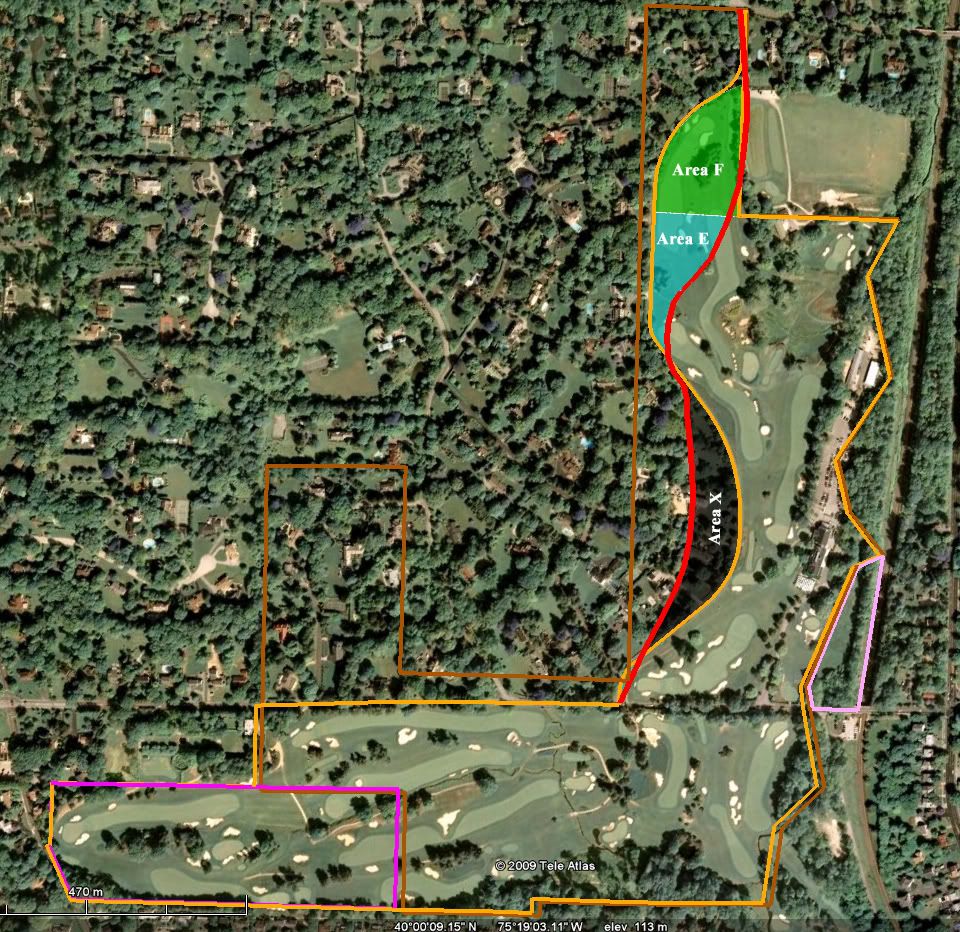
Entering the realm of speculation,

let's assume that Francis was looking at a map with a 117 acre boundary that looked like Mike's mirror road (which actually does define 117 acres);

which road makes some sense since it comes down the Haverford College boundary and doesn't create any useless triangles;

and, Francis says to himself, damn, those last five holes just aren't going to fit up there in the north end;

so, he says to himself, we need to get some more acre to the west of the mirror road up towards the north end, let's cal that Area E (for extra acres);

but, then sheesh, we still can't fit those darn five holes in;

but, if we got a 120 x190 yard area up next to Haverford College that we'll call Area F (for Francis) we could run a hole up there and then come back down;

but, Lloyd and Connell are not happy that we're biting so much into the development land, so we'd better give them some acres back somewhere else;

well, we don't really need all that space across from the clubhouse, that we'll call Area X (for eXtracted), so why don't we swap it back to the development side and let them build those big mansions there.

So, the boundaries were redrawn, the acreage worked out to 120 and Lloyd was able to secure it for the same price as the 117.  A great couse gets built and all live happily ever after (at least until 2009).

For the record:

Mirror Road golf course area            117.0 acres

Area F                                               4.8 acres

Area E                                               3.2 acres

Area X                                               5.0 acres

Merion July 26, 1911 acreage            120.0 acres

And, there you have it, a scenario that accommodates Francis' description of the "swap" and the addition of three acres by July 26, 1911.


Mike_Cirba

Re: The Merion Timeline, or Jeff Brauer Unties The Gordian Knot!
« Reply #1718 on: June 19, 2009, 06:35:39 AM »
Bryan,

Hey, I thought you didn't like my "doppelganger" road idea!   :-\ ;) ;D

Very creative effort there....although I think you might agree that the odds of Jeff's theory being the correct one here is about a 90% greater chance than either of our attempts.  ;)  

In either case, it's nice to know we're on the home stretch here.

Jeff/Bryan,

I wouldn't worry too much about the fact that only a few of us are left here civilly working this problem to conclusion.  

There are a lot of eyes on this thread.
« Last Edit: June 19, 2009, 06:43:51 AM by MCirba »

Jeff_Brauer

  • Karma: +0/-0
Re: The Merion Timeline, or Jeff Brauer Unties The Gordian Knot!
« Reply #1719 on: June 19, 2009, 08:46:17 AM »
Good morning.

Bryan,

On the map I posted last night, my east west dimensions match yours perfectly, by my NS dimension along Haverford is 3565 vs your measurement of 3265.  Just checking to make sure yours isn't a typo before re-scaling any maps. Its not unusual for stretch to occur in drawings and we deal with that all the time.

Thanks for the newest graphic. I really didn't understand the mirror road theory.  Its still pre-coffee, but my first take is that while the acreages work out fine, there is no evidence that this was ever considered. Is that correct?

As I said last night, I have some real world stuff to get out today, so I am not trying to add drama to this (or add to the Merion Time Line) but I will try to scale it in CAD quickly when I get the chance.
Jeff Brauer, ASGCA Director of Outreach

Mike_Cirba

Re: The Merion Timeline, or Jeff Brauer Unties The Gordian Knot!
« Reply #1720 on: June 19, 2009, 09:07:18 AM »
Jeff,

Yes, there is no other suggestion of evidence for the doppelganger road theory than my own overly imaginative meanderings that seem to have infected Mr. Izatt.  ;D

Niall C

  • Karma: +0/-0
Re: The Merion Timeline, or Jeff Brauer Unties The Gordian Knot!
« Reply #1721 on: June 19, 2009, 11:34:27 AM »
Mr Cirba, Mr Brauer and Mr Izatt, I shall be writing to the Nobel Peace Prize committee suggesting that they honour you for your invaluable services to peace breaking out on GCA.

Now, remind me, who was it that designed Merion ?

JESII

  • Karma: +0/-0
Re: The Merion Timeline, or Jeff Brauer Unties The Gordian Knot!
« Reply #1722 on: June 19, 2009, 11:46:27 AM »
Now this feels like actual progress...thanks Jeff and Bryan for some real and helpful stuff...and you to Mike for figuring this thing out so many times thus far...

So a couple of thoughts
1) We're going to assume the comments identifying 117 acres meant nothing in November 1910? But that the "approximate road" meant everything...
2) We're also going to assume that no routing work was done between an option on the land and the actual purchase of it?

Mike_Cirba

Re: The Merion Timeline, or Jeff Brauer Unties The Gordian Knot!
« Reply #1723 on: June 19, 2009, 12:11:35 PM »
Now this feels like actual progress...thanks Jeff and Bryan for some real and helpful stuff...and you to Mike for figuring this thing out so many times thus far...

So a couple of thoughts
1) We're going to assume the comments identifying 117 acres meant nothing in November 1910? But that the "approximate road" meant everything...
2) We're also going to assume that no routing work was done between an option on the land and the actual purchase of it?

Jim,

Me too??  ;)

In answer to your questions....and I hesitate to speak for Jeff, but this is my understanding.

1) No, it meant that they secured 117 acres and that was the goal.   But to Jeff's point, they didn't restrict the designers to some tight 117 acres on the Land Plan or draw the "approximate road" that tight.   They drew the line a little more liberally (122 acres, according to Brian) and then would work from the goal of trying to reach the magic number as things became finalized.   He's surmising they were able to give back around 5 acres along the length of it, but also had to purchase another 3 they didn't expect.

In other words, they couldn't make the 117 acres work.   They needed 120.    Actually, they needed 123 because they also used the 3 acres of leased Railroad land.

When you read what Francis wrote about fitting the first 13 but not being able to fit the final five holes it takes on a bit of a different meaning and I think Jeff has nailed it.  

2) Not necessarily, although I think we also know that the original "almost 120 acres" being optioned in July 1910 and the 161 acres Lloyd took title to in December was not the same land overall.   Even if we want to assume that it was all inclusive, or that they figured they'd use the Dallas Estate back in July when it wasn't under HDC control until October, there is no evidence of any routing taking place over that time period.   That might not seem logical in some ways but we do know for certain that as of Nov/Dec 1910 there was no routing completed and much routing work and many different routing plans took place after that time.    I think what we're concluding here is that without some further evidence of actual routing work by anyone during those months in 1910, anything else is highly speculative.
« Last Edit: June 19, 2009, 12:24:42 PM by MCirba »

JESII

  • Karma: +0/-0
Re: The Merion Timeline, or Jeff Brauer Unties The Gordian Knot!
« Reply #1724 on: June 19, 2009, 12:23:04 PM »
Thanks Mike,

Interestingly, the Cuyler words about no definite course yet or something similar clearly implies what we've agreed verbally...these guys were tinkering prior to the official dates on deeds and such, agreed?


Tags:
Tags:

An Error Has Occurred!

Call to undefined function theme_linktree()
Back