News:

This discussion group is best enjoyed using Google Chrome, Firefox or Safari.


Jason Topp

  • Karma: +0/-0
Sleuthing With Aerial Photographs
« on: January 19, 2006, 02:29:35 AM »
I wrote a "My Home Course" about Oak Ridge last fall.  When researching for that piece I found a number of aerial photographs from the local library and historical society.  I thought people might be interesting in seeing how a 1920's era course evolved.

The first photo was the biggest surprise to me.  According to the information I initially read, I thought the entire course was built by 1925.  Imagine my surprise in seeing this 1940 photo:
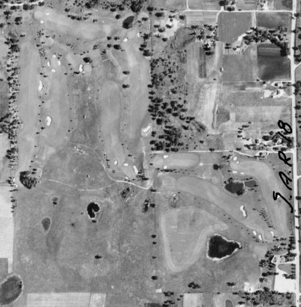


Only nine holes!  It is the current back nine, which still has the same routing, but it looks like a couple of interesting bunkers were lost since this photo.

Based on the next photograph and some additional information, I learned that the second nine was built around 1940 or 41.  This photo is from 1945:
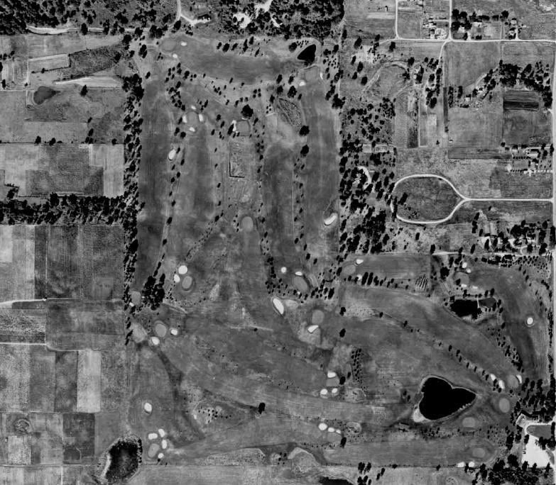


The most interesting hole to me is in the bottom left, which shows what appears to me to be a short par four or long par three that no longer exists.  In addition, there is a par three over a lake at the bottom right portion of the photo that I did not expect to see.

This 1950 photo appears unchanged from 1945, but is a bit more clear:
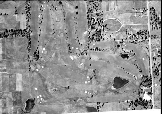


In 1960 - 2 additional holes were added at the bottom left to replace the 2 "suprise" holes from the earlier photos.  Some additional holes were reshuffled.
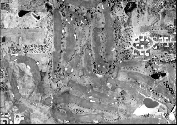


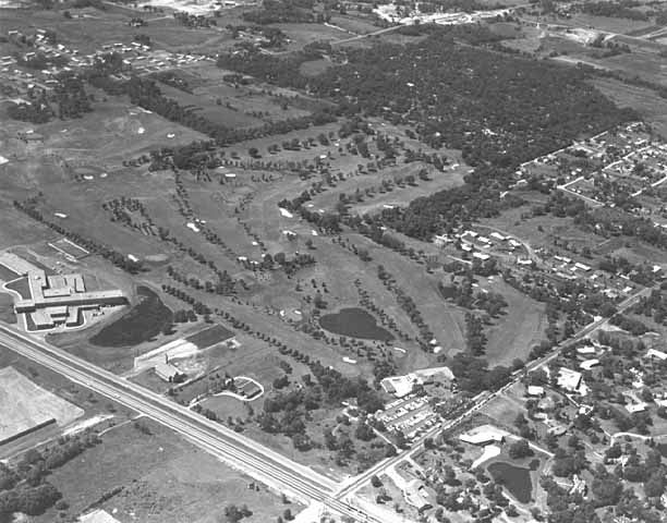
Here is an oblique from 1959.  Obliques are valuable because they give more of a 3 dimensional sense of the course:


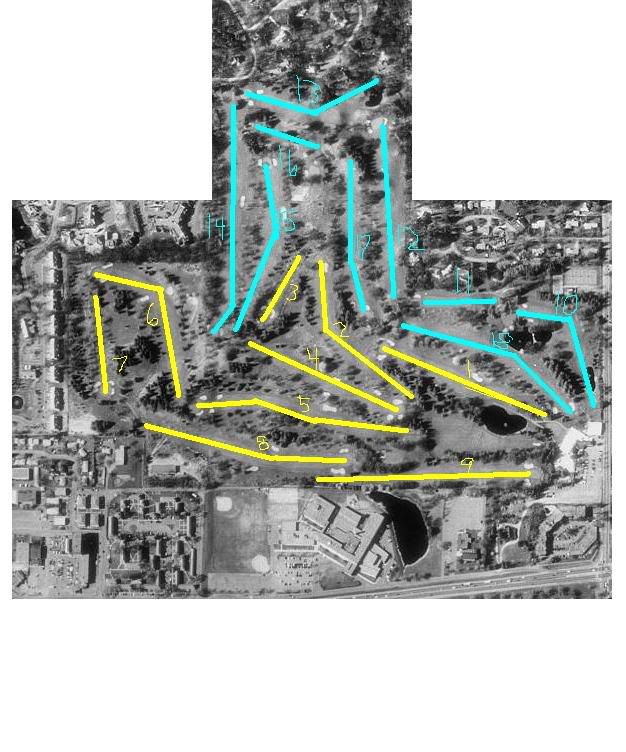
This is a 1991 aerial in which I have marked the hole numbers.  Note the impact of trees.  

Since 1991 time, there have been a number of additional alterations.  Google Earth has a great aerial that catches them all except for an expansion of the practice range and a change to the first hole completed last year:


If you are interested in your course's history, I encourage you to check with your local historical society or university library and ask what the best source of such photographs is in your area.  You may be surprised.  I was!
« Last Edit: January 19, 2006, 02:29:50 AM by Jason Topp »

RJ_Daley

  • Karma: +0/-0
Re:Sleuthing With Aerial Photographs
« Reply #1 on: January 19, 2006, 02:53:34 AM »
Nice research Jason.  The loss of bunkers that most stands out to me are the mid fairway B on 10, and the cross bunker on 18.  They seem to have disappeared with 18 lost '40-'45 and 10s around '50-60.  I wonder why, since they look so integral to those hole designs.
No actual golf rounds were ruined or delayed, nor golf rules broken, in the taking of any photographs that may be displayed by the above forum user.

Jason Topp

  • Karma: +0/-0
Re:Sleuthing With Aerial Photographs
« Reply #2 on: January 19, 2006, 03:22:55 AM »
Nice research Jason.  The loss of bunkers that most stands out to me are the mid fairway B on 10, and the cross bunker on 18.  They seem to have disappeared with 18 lost '40-'45 and 10s around '50-60.  I wonder why, since they look so integral to those hole designs.

Dick - In recent renovations they put a bunker back in on 18, although it does not have the interesting shape that it did then and is positioned to the side of the fairway rather than the middle.  It would have been quite a poke to get past it off the tee in 1940, probably about 275 yards.

The bunker on 10 probably went out because the trees grew up at the corner of the dogleg.  It was probably about 170 yards off the tee so it would have annoyed a high handicapper but not a low handicapper.

The bunker that surprised me is at the inside corner of the dogleg on 2.  There are some goofy high mounds there now, and I can only assume that those were the edge of the bunker, which would have made that thing very deep.  Unfortunately, someone planted trees between the bunker and the green, so I'm sure that bunker came out when the trees grew too high.  I would love to see the bunker without the trees.

wsmorrison

Re:Sleuthing With Aerial Photographs
« Reply #3 on: January 19, 2006, 06:28:42 AM »
Jason,

Are you certain the course wasn't 18-holes (or at least more than 9 holes) and then 9 (or some) were abandoned for a time due to Depression or other factors?  

While it doesn't look like the holes were reclaimed, the first photo shows that there may be some abandoned greens (directly below the rightmost bottom green on the hole with the center-line bunker) and also the outline of a dogleg left even with the pond and above the whiteish area on the bottom left.

I don't know anything about the course or its history, but it seems to me the photographic evidence of that truncated first photo maybe should not be considered conclusive evidence that there weren't more than 9 holes prior to 1940.  If Craig Disher weren't in the remote regions of Montana he could weigh in on this.
« Last Edit: January 19, 2006, 06:34:07 AM by Wayne Morrison »

Jason Topp

  • Karma: +0/-0
Re:Sleuthing With Aerial Photographs
« Reply #4 on: January 19, 2006, 08:27:15 AM »
Wayne -

I am certain because our greenkeeper has the notes from the greenkeeper during this time period.  I noticed the same thing you did however and think it is possible that the new nine was in construction at the time the photograph was taken.  It is the earliest one I have so I do not know what it looked like prior to 1940.
« Last Edit: January 19, 2006, 08:27:32 AM by Jason Topp »

Scott_Burroughs

  • Karma: +0/-0
Re:Sleuthing With Aerial Photographs
« Reply #5 on: January 19, 2006, 10:32:01 AM »
This is so funny.  I did this same thing with a more well-known course a couple of years ago, showing the course's evolution through the years (and a significant change that occurred)....but I never finished the write-up (to this day).  Then Michael Prystowsky submitted the same thing on Westchester CC as an In My Opinion piece soon after I had finished the aerial work and I thought that I'd submit mine soon after....but still nothing.

Nice job, Jason.  It's neat to see the evolution of a course in this manner.

Maybe I'll get to mine one of these days.
« Last Edit: January 19, 2006, 10:32:38 AM by Scott_Burroughs »

Mark_Guiniven

Re:Sleuthing With Aerial Photographs
« Reply #6 on: January 24, 2006, 12:17:48 AM »
Scott,
I guess modern aerial photographs are taken with some pretty sophisticated kit, constant altitude, motion compensation etc, and then lots of individual images are stitched together. Old aerials are just one photo, so you get lens distortion at the fringes.

I had a go trying to overlay a 1978 course aerial on top of a modern 2001 aerial. I got everything rotated and re-sized perfectly, they wouldn't match up. Using transparency layers, I'd get the bunkers on one green lined up perfectly, but then other greens would be out.

How do you remove the distortion in the old aerials in paintshop/photoshop?

TEPaul

Re:Sleuthing With Aerial Photographs
« Reply #7 on: January 24, 2006, 07:41:09 AM »
Looking at old aerial photographs of courses is the very thing that got me hooked on golf course architecture in the first place. I can distinctly remember my first thought looking at my own course in an aerial from 80 years ago. My first reaction was; "My God, it looks so different!"   ;)

Tags:
Tags:

An Error Has Occurred!

Call to undefined function theme_linktree()
Back