
The Sunningdale Story
pg. 2
There is a story connected with the small bunker in between the two cross bunkers near the green at the latter (sixth) hole, some time known as “Monty’s” bunker. R.H. Montmorency could not always carry these bunkers with his second shot, but he was so accurate that he could play between them. This bunker was made to foil him! (Recently some alterations to the approach to this green have been made and “Monty’s bunker no longer exists).
“Monty’s bunker” at the sixth green was placed be-tween the two bunkers short of the sixth green, but was created after the Sphere schematic had been published. De Montmorency, a retired Eton schoolmaster, was a good enough golfer to have represented Great Britain in the match versus the United States that led to the donation of the Walker Cup by George Walker, grandfather of the first President Bush.
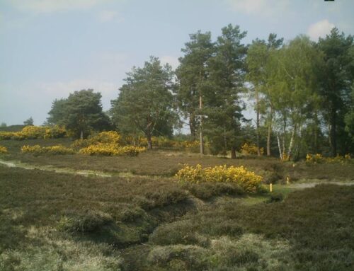
The original seventh green was away down to the left of the present green, a bit of ground now completely overgrown with trees and scrub (see figure 6).
The long disused bunker in the side of the hill which was carried by the second shot can easily be seen. Over it the ground sloped down to the invisible green. The teeing ground to the eighth was near to it and the green was very different in shape. Whilst the present green was being made, a temporary green was cut out of the side of the hill on the left and its site can easily be seen by the discerning eye.
Changes to the seventh and eighth holes
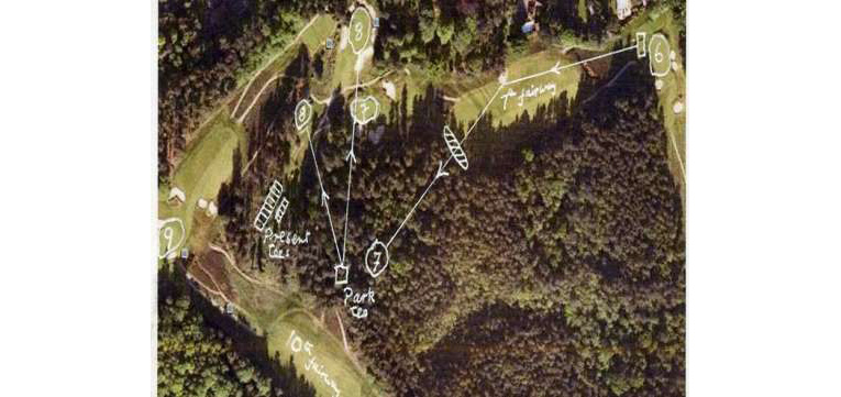
Figure 6 – Changes to the seventh and eighth holes
Figure 6 is a Google Earth diagram that covers the sixth to the ninth holes of the Old Course, and some of the tenth. At its top right is visible the fairway approach and sixth green of today’s Old Course, with the seventh tee just above it. In Park’s time the tee was similarly placed and the drive over the hill was the same as it is today, but the hole was a left handed dog leg rather than today’s slightly right handed shape. The second shot was played about 30 to 40 degrees left over the middle of the disused cross bunker by the “all clear” bell in the side of the hill, still a feature today.
The green was down the hill another 100 yards, and it is possible to recognise features of this green, such as the built up lower border. There is a healthy 70 year old chestnut tree, probably planted in the middle of the green, a habit which is found on other disused greens, for example the now hidden Colt seventh green of the New Course, where only the stump remains. There is also a large greenkeeping rubbish tip on the present site of the green, which can be found 110 yards away from the centre of the present seventh green on a line close to due East.
The Willie Park eighth tee was sited in the woods be-low today’s tee, and is visible on the track through the wood as a flat built up area attached to the track. A temporary eighth green was constructed to the left and short of the present permanent green while it was under construction (see photos in figures 9 and 9A).
When Colt made alterations to the course around 1910 he created the much higher present tees to give a straight shot in to what had earlier been a blind hole.
Bernard Darwin had plenty to say about the seventh and eighth Park holes and commented that the changing of the eighth tee up to the present level had greatly improved the eighth hole.
These comments can be read in the “Golf Courses of the British Isles”, 1910 (ref 7). Darwin believed that Harry Colt had made a number of substantial improvements to several holes of the New Course, when he wrote his book.
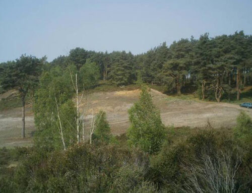
Figure 7 – Figure 7 shows the site of the lost Park seventh green of the Old Course.
The fairway view seen in the photo above through the trees is that of the tenth hole of the Old Course. Most of the original seventh green is covered with a greenkeeping rubbish tip but the feature that identifies this green beyond reasonable doubt is the built up lower border. There is quite a sharp drop if one walks in the direction of the tenth fairway.
This built up border to the green is not explainable by any geological or soil mechanical event and is quite distinct when the searcher does locate it, which is best found by walking along the footpath through the wood until one reaches a point where the present seventh green is more or less due west, and at that point the green is about 15 yards to the east.
The public footpath referred to meanders across the tenth fairway at the bottom of the hill, through the wood and then approaches the current seventh green before turning right and heading off towards the seventh tee through the woods to the east of the seventh fairway. In the other direction direction it crosses the Colt lost ninth fairway on the New Course (see Figure 32) and eventually finishes on the Chobham Windlesham road near the Brickmaker’s Arms, a public house with an exceptional restaurant which has long been a haunt of many Sunningdale member, and golfers from other local clubs.
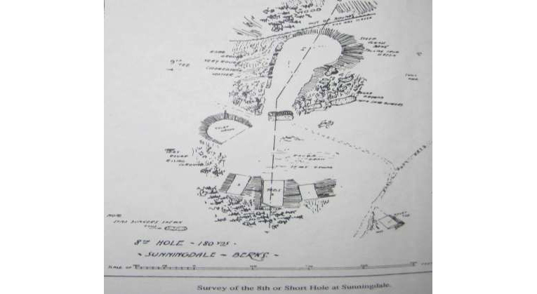
Figure 8
Figure 8 shows is the plan for Colt’s relocation of the eighth tees higher up the hill. At the bottom right is seen the obliquely angled square, labeled as “relief tee”, and pointing at the “relief green”. This was the tee used when the Park relief green shown centre left of the diagram and photographed on the next page, was in actual use.
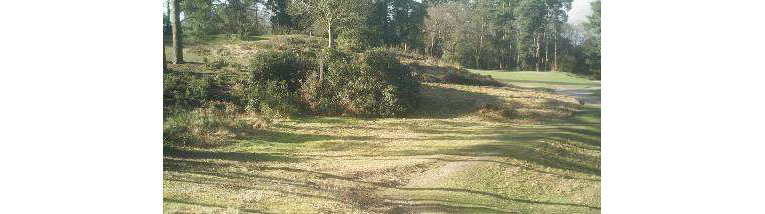
Figure 9
Figures 9 and 9A (see ref 4) show the original eighth green, foreground left, as seen today and as seen in 1910. The original green on the left was built as a temporary green during construction of the current green. The original tee was down in the wood about 160 yards to right of the original green. The current green is in the background in both photographs.
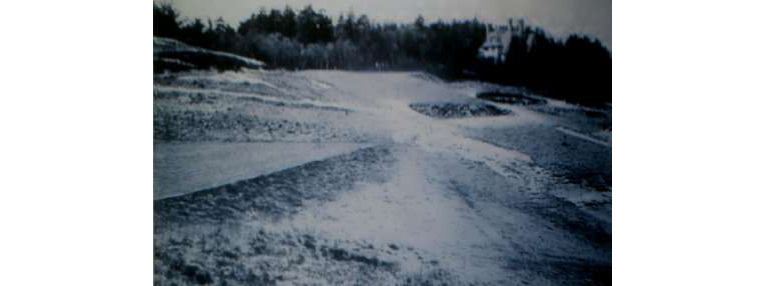
Figure 9A
Except for bunkering, the ninth remains practically the same and at one time was a great cause of congestion in a tournament. The writer remembers on one occasion during play for the Golf Illustrated Gold Vase, there were no less than nine couples waiting on the tee. On this occasion Cyril Tolley was so disgusted at the long wait that he gave up and walked back to the Club House.
The tenth remains the same, except for the bunker in the middle which was originally much nearer to the tee. (This view is featured in the well known water colour by Harry Rountree in Darwin’s “Golf Courses of the British Isles” (ref 7).
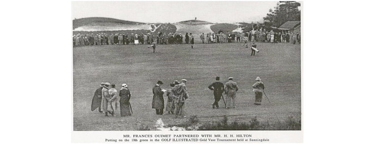
Figure 10
Figure 10 shows how large was the Willie Park tenth green, adjoining the Half Way House, which Bernard Darwin describes in his book (ref 7), as being the repository of “apples and ginger beer, and other things”, which suggests a covert availability of more serious refreshment.
The 1914 Golf Illustrated Gold Vase was won by its editor, Harold Hilton. His playing partner, Francis Ouimet, pronounced “Ointment” by his caddie, as described in “Sheridan of Sunningdale” published in 1967, had just won the US Open Championship.
The eleventh tee must have been down on the lower ground to the left of the photo in Figure 10 and in front of today’s back tee which would bring the large left hand bunker into direct play, as Darwin comments that a topped drive would lodge therein. Today that bunker is overgrown with heather, and is well to the left of the line of play.
The original Park eleventh green was about sixty or so yards to the left of today’s green, making the left hand bunker a formidable obstacle. The main sand bunker affecting today’s play was beyond and to the right of Park’s bunker and was originally a rough sand and heather mound.
Colt moved the green to the right and to its present location and is seen on that green in Figure 11.

Figure 11
Figure 11, courtesy of Old Golf Images, (ref 9) shows Colt inspecting the eleventh green on the old course with the head Greenkeeper, Jim McLean.
The eleventh green was a double one. The left half can still be seen, with the valley between the two halves. There was of course no bunker in the valley. (see earlier comments. Guy Bennett did not have access to the photo in Figure 11 which shows a bunker in the valley)
There was an awkward diagonal ditch across the middle of the twelfth fairway and the green was on the low ground in front of the stables. The present green was designed and built by H.S. Colt as was the present seventh green.

Figure 12
Figure 12 is taken from “The architectural side of Golf” 1929 (ref 6) by HN Wethered father of Joyce Wethered, later Lady Heathcote Amery, and Tom Simpson, who later redesigned a number of holes on the New Course, and created its “loop”. The loop was originally played clockwise, the reverse of today’s layout, which is covered in some detail later in this booklet.
It shows Colt’s change to the twelfth hole, as the original Willie Park green was down to the right and short of the present green depicted here. Joyce Wethered won the second and third Sunningdale foursomes events in 1935/6, partnered by another club member, JSF Morrison, who played a part in the partial elimination of the Simpson holes on the New Course, in a partnership with Harry Colt. Morrison was well known in the sporting world, as he had represented Cambridge at cricket, golf, and association football.
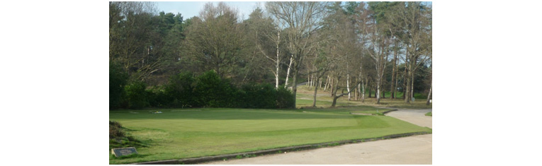
Figure 13
Figure 13 shows the area of the original twelfth green opposite the location of the old “stables” is now a turf nursery.
The thirteenth hole was quite different. It was a blind one-shotter from a tee near the approach to the present twelfth green, over the hill to the site of the present green.
The tee was later changed to the top of the hill, a tee now being brought into use again. When the tee was moved to the top of the hill, the centre bunker, about half its present size, was sited in the middle of the putting surface. It was much criticised and known as “Colt’s Po!”
Except for bunkering, the fourteenth, fifteenth and sixteenth are very little changed, but it may be remarked that the bank and the ditch running along the right side of the fourteenth and fifteenth marked the boundary of the land leased from the College. Over the other side was the “Common”. There was a small teeing ground to the fifteenth, now disused, over the bank to the right of the present medal tee. I believe it was “Monty’s” (De Montmorency (see fig 5) idea to have one there, and “Mac” always called it the “Tee on the Common”. (In the 1990s this tee was rebuilt as the current medal tee.)
It may be noticed, especially in winter, that the left half of the fourteenth fairway, and also part of the left of the twelfth fairway, and the second up to the road, are inclined to be soft and “worm-casty”. This was caused by repeated dressings of lime in the early days, which altered the character of the turf. This lushness may be noticed at many of the near approaches to some greens, more especially the third, sixth, fourteenth and fifteenth. The reason for this is that they were originally part of very large putting greens.
The “St Andrews” double green
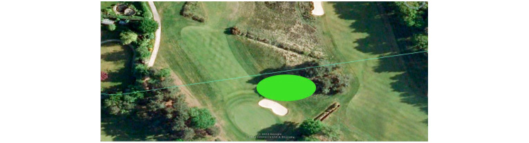
Figure 14
Figure 14 shows the original Old Course first as now and seventeenth double green, similar to those found on the Old Course at St Andrews. The bunker may not have been there, in the years of the double green.
There have been, through the course of the years, three different greens for the seventeenth hole. The first of these was driven from a high built up teeing ground straight down the hill. The first and seventeenth formed a large double green. And near the site, in the direction of the Clubhouse, there can still be seen the shape of the tee to the eighteenth. It was easy to slice out of bounds, which was marked by the bank running down the right hand side of the hole.
The site of the second green to be made on the seventeenth was immediately below the present green, making the hole almost a complete right-angled dog-legged hole. Driven from the same tee, it was still easy to go out of bounds if the player tried to cut too close a corner. The present green was designed at the time of the making of the New Course in order to make room for the first and last holes to run side by side.
The Luftwaffe Alterations
The original eighteenth hole was much longer than at present, driving from the teeing ground referred to above, near the clump of trees, to a green not far from the hedge bounding Holiday House and in a line more or less half way between the present eighteenth greens of the Old and New. Like the seventeenth, the eighteenth green was re-sited nearer the big oak tree in order to make room for the New Course. It was larger than at present with a very wide entrance so that any sort of second shot, given sufficient length, could find it. In the autumn of 1940, a squadron of German planes dropped upwards of ninety high explosive and incendiary bombs in and around Sunningdale.
One of the former made a large crater on the right hand near side of the green. Whilst clearing up the mess, someone had the bright idea of making two insidious bunkers on the site of the bomb hole, thus transforming the second shot from very ordinary to first class. It is amazing how many balls they catch. The writer on one occasion counted nine consecutive professionals playing their seconds into or to the right of these bunkers. The large bunker to the left of the drive, once called “John’s” bunker, after its designer John Morrison, was so placed to check those who essayed to drive too much on to the first fairway.
So much for the almost too popular Old Course! Dur-ing the years many amateur and professional tournaments have been played there and records broken. Though individual rounds of 65, 64 and 63, the latter the present record held by Norman von Nida have been made, probably the most famous were the two rounds of 66 and 68 by Bobby Jones in qualifying for the Open Championship in 1926. The two rounds contained only one 5 and one 2.
More remarkable perhaps is the fact that in one of the rounds Jones used a two iron on no less than eight occasions, which demonstrates the length of the course. With today’s conditions and equipment it would require a course of more than 8000 yards to require such treatment.
What of the putting greens? In these days of scientific green-keeping, most courses have excellent putting surfaces at certain times of the year, but year in year out and day in day out, the Old Course greens are as good as any. In the past they have had their diseases, such as fusarium patch and leather jackets. Now, thanks to the various research stations, these diseases can be scotched before they appear. “Mac” always said that the original greens were laid with turf cut from the roadside! I have little doubt that the turf on some of the remaining original greens, such as the tenth, fourth and sixth, is descended from that self same “roadside” turf.
Before the New Course came into existence, there was a 9-hole course, starting and finishing where the practice ground is today and played around Titlarks Hill. It was known as the Sunningdale Heath Golf Club, and later the “Chauffeur’s” course and the “nine ‘ole”. The green fees it brought in were sufficient to pay the wages of one man to look after it.
There is a description of the layout of the Chauffer’s Course in Whitfield’s history of “Sunningdale Golf Course 1900-2000” (ref 1). This was provided in around 1990 by one of the Clubs oldest members, Stephen Sillem, whose family lived before WW-1 in a large house off the Chobham Road named Parkers Hill, now known as Park Hill. This house was close to the sixth green of the Chauffer’s Course, and Sillem recalled using this sixth hole as his private practice ground in the early years after the formation of the Club.
There is an Appendix (figure 47) featuring a Google Earth map of the Chauffer’s Course areas in which the lo-cation of the holes have been superimposed, based on the Sillem descriptions in the Whitfield history.
The Chauffer’s course occupied some of the land now used for the New Course, and its construction meant the closing of this popular nine holes circuit.
The New Course
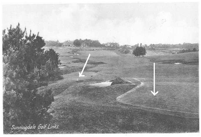
Figure 15
Figure 15 shows the original first green of the New Course which occupied the area now used for the men’s eighteenth white tee. It is clearly apparent in the right foreground of the Figure 15 postcard photo, as is the original white eighteenth tee post, from which the drive was onto the side of the hill to the right of the copse, and therefore cut across the approach to the first green.
The photo on the next page shows the first green just below and between the two flat areas, right skyline, which were tees for the second hole. It was taken from an area in front of today’s eighteenth tee of the Old Course, and the New Course seventeenth green is visible on the hill just left of the left hand copse, similar to today’s location.
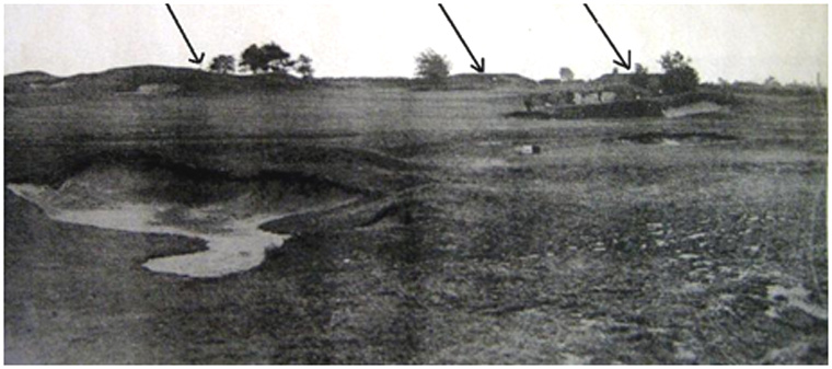
Figure 16
Figure 16 shows the original approach to New Course first green in distance between two flat areas upper right.
The original New Course was laid out by H.S. Colt, and came into being in 1922. Lord Dunedin, Captain of the Club for three years, oversaw the legal side of the new land tenure. For construction of the course, laid out largely on Chobham Common, the Club purchased the freehold of the land, subject to commoners’ rights. There is a right-angled corner stone near the fourteenth tee and lines drawn eastwards from this to a stone on the boundary of Park Hill, a house built by H.O. Sillem and now occupied by J.R.A. Strovan, and north westwards to Upper Ribsden, built by Gordon Anketell, mark the boundaries of the freehold property. In addition the Club acquired a lease and yearly tenancy at a peppercorn rent from the Lord of the Manor on the part of the Common up to the cross roads. Part of the present sixth, seventh and eighth holes lie on this portion.
A number of the holes of the New Course are substantially the same as those laid out by Harry Colt. The second, third, fourth, fifth and eleventh to seventeenth come into this category, though the fourth and twelfth had, for a short time, alternative greens. The latter were not popular and the original greens were taken into play again.
The first hole was at first played from about the site of the present eighteenth green to a green in a small amphitheatre below the seventeenth green. The eighteenth was played across the approach to the first to a green where the first tee is now situated. Thus the two holes were played in more or less reverse directions to the way they are now.
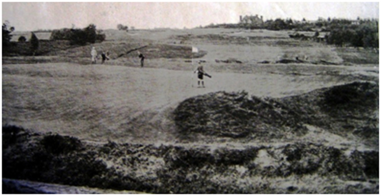
Figure 17
Figure 17 shows the third green of the New Course, looking back towards the tee, shortly after the course was opened for play. Certain features of this hole are recognizable today; for example the awkward bumps in the right foreground at the back left of the green and the fold in the green on the left.
The large house at the top of the picture is the house that today looks through birch trees and over the seventeenth hole of the New Course. The fairway and approach to the green of the sixteenth hole on the Old Course is seen in the upper left of the photograph. Stockings and shorts were the young caddy’s dress.
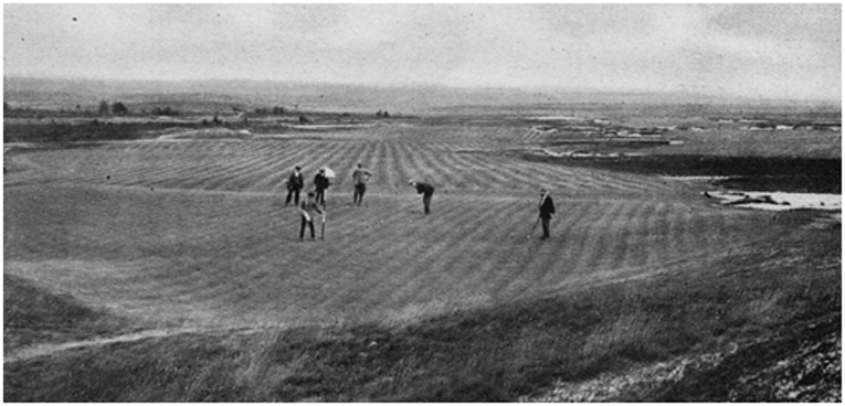
Figure 18 (By courtesy of Suttons Seeds Ltd)
Figure 18 shows the1924 treeless photograph of the New Course fourth hole, which was used in the 1924 Darwin booklet (ref 3). Figure 18A is today’s view from a similar spot, just behind the fourth green. 88 years of tree growth!
Figure 18 A – By courtesy www.golfclubatlas.com ref 10
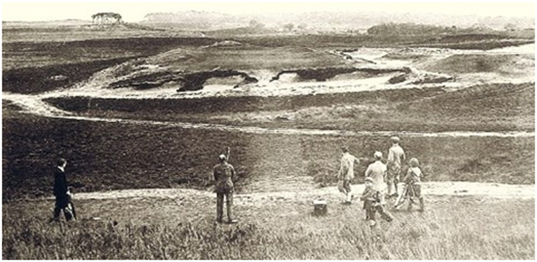
Figure 19
Figure 19 by courtesy of Old Golf Images ref 9 shows the fifth hole in 1924. This tee is currently the ladies tee of the today’s thirteenth hole of the New Course. The photo in Figure 19A was recently taken from a similar site. In 1924 the hole was played uphill to the elevated green, rather than from today’s more elevated tee up the hill to the right, with the shot across the valley.
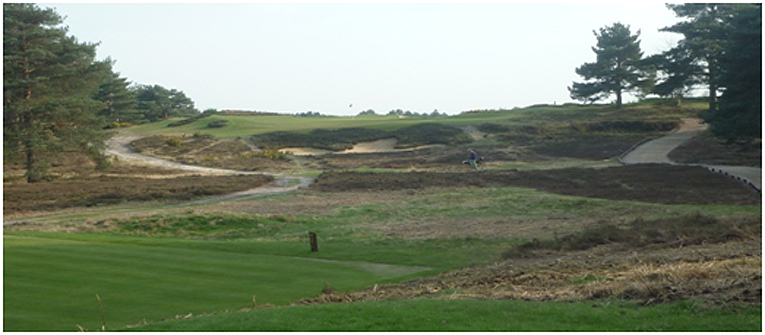
Figure 19A