News:

This discussion group is best enjoyed using Google Chrome, Firefox or Safari.


MCirba

  • Karma: +0/-0
The Re-Routing of Cobb's Creek
« on: March 06, 2019, 10:46:50 AM »
It’s probably not well known here over a decade later that our efforts to restore Cobb’s Creek Golf Course in Philadelphia started with us just trying to find evidence that 1) Hugh Wilson was actually involved with the design and 2) information that showed the original course routing as local lore said that the course was considerably changed over time with several different versions on the particulars.

As regards the latter, back in September 2007 I sent an email to the Hagley Museum in Delaware, aware that their “Dallin Aerial Collection” featured many early aerial photos of courses in and around Philadelphia, asking if they had anything on Cobb’s Creek.   I did not get an immediate reply and about six weeks passed before one day I received a response with 8 aerial images attached.   After excitedly scanning the images, I started the following thread on GolfClubAtlas that turned into a wonderfully collaborative endeavor that really launched the project.

http://www.golfclubatlas.com/forum/index.php/topic,31872.0.html   

What we eventually learned was that in 1953 about 15% of the original golf course was leased to the United States Army for an Air Defense Base (presumably to shoot down the Soviet plane dropping the Big One on Philadelphia), where it remained for 5 years.  In 1958 the Army moved out but apparently at the time the original routing was unrecoverable likely due to five years of growth along the former avenues of play.

Although the following articles indicate a belief that the course wouldn’t need much reconfiguration to accommodate the Army, in total six of the very best holes were rerouted in a much more constricted way, as the loss of land negatively affected the overall width of the property.   Once we learned how the course was originally routed, we were essentially blown away by the boldness and ingenuity, and since all of the land in question was still there (the Army Base had become a public driving range), along with all of the greensites, some of us began to wonder aloud what would be required to restore the genius of the original routing.


Over the years we’ve been able to collect a number of contemporaneous artifacts that we’ve turned into a two-inch  thick book telling the stories we learned through mostly Joe Bausch’s incredible research efforts, and we were also able to get a copy of the original routing map (on a topo) from 1915.

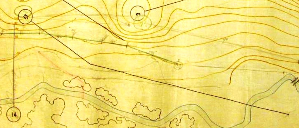
We also had in our possession another map, undated, but signed by Alan Corson who was Chief Engineer of the Park.   On this map was drawn in pencil a “new” 17th hole that was created around 1927 that replaced the original 14th at the time for a number of reasons including the enforcement of “Blue Laws” in neighboring Delaware County.   Irrespective of the reasons, we concluded that this was a change for the better as today’s 17th is simply an awesome hole.   

Until this past weekend, I simply assumed that this map was used for the purpose of locating the 17th but there were other vague markings that until I magnified the view on my computer I never was able to determine exactly.   What I then realized is we had the map used in the 1950s to figure out the re-routing once the Army took over the original 13th hole!   Our research indicates that this work would have been done by Garrett Renn (Superintendent of the Philadelphia public courses who designed several courses in the area), likely with George Fazio who represented the courses as the professional.

It’s an interesting document considering the process architects use when such circumstances arise as loss of course property.   I’ll comment further if this thread progresses as time permits, but right now I just would like to get these images posted for the curious.   

Here’s a portion of the map in question showing the original routing;.   As mentioned, until this weekend I really didn’t see the forest for the trees.


The first five holes remained the same as originally routed, but the first change took place on the 6th hole, with a short par three tee shot over the creek to the original 12h green.   We remain perplexed as to why this map shows the 5th green where it does which seems in error as it has always been loved further to the right along the creek, but no matter.   This one is the toughest to see with a very faint pencil line drawn as described above.


The next snippet shows the new 7th hole, which was routed from the front 13th tee to the original 9th green.


Following is the new 8th hole, from the original 10th tee to the original 13th green.   It also appears that an effort is made to indicate the new boundary line, perhaps in the form of a fence, which extends along from the left of the photo and runs just below the original 13th green.


More to follow…

« Last Edit: March 06, 2019, 04:07:16 PM by MCirba »
"Persistence and determination alone are omnipotent" - Calvin Coolidge

https://cobbscreek.org/

MCirba

  • Karma: +0/-0
Re: The Re-Routing of Cobb's Creek
« Reply #1 on: March 06, 2019, 04:05:52 PM »
I probably should have done this after posting the new hole 7, but it appears the architects played around with potentially creating some brand new holes to entirely new greensites.   For instance, there are two holes drawn below hole number 7 that look to be a par three and a shorter par four to a green near the creek.   

Those holes were never built, but as you'll see later on a portion of the map where the yardages of the new holes are listed, the stretch around 7, 8, and 9 were still in the process of determination.


What is today the 9th hole was shortened by about 80 yards with the loss of land and a new tee created north of the new boundary, but otherwise the hole remained it's routing.

Today's holes 10, 11, 12, and 13 retained the original routing, but today's hole 14 used the tee of the original 9th hole and extended 600 or so yards to what was originally the par three 10th green as seen below;


Because the new 14th now used a large portion of the original 11th hole's fairway, that hole was shortened from a par five to a par four with a different angle and today plays as the 15th.


The new 16th was drawn at this time as a par three from near today's 14th tee and was essentially the second shot on the old 6th.   Eventually a tee was created slightly further back to play as a dogleg very short par four.


Finally, here's the state of the sketchpad of yardages reflecting it's particular moment in time as a re-routing work in progress;


I'd be happy as time permits to answer any questions or provide any additional information to interested parties, thanks.

« Last Edit: March 06, 2019, 04:12:39 PM by MCirba »
"Persistence and determination alone are omnipotent" - Calvin Coolidge

https://cobbscreek.org/

MCirba

  • Karma: +0/-0
Re: The Re-Routing of Cobb's Creek
« Reply #2 on: March 06, 2019, 04:47:13 PM »
Not surprisingly, once you see the penciled re-routing exercise, you really can't un-see it, as this final view of the original map makes clear.   Amazing how you can look at something so many times and still not see the whole picture or realize exactly what you're seeing.

Either that or I need a visit to the eye doctor.

"Persistence and determination alone are omnipotent" - Calvin Coolidge

https://cobbscreek.org/

Kyle Harris

  • Karma: +0/-0
Re: The Re-Routing of Cobb's Creek
« Reply #3 on: March 07, 2019, 02:09:08 PM »
I don't know that today's 16th wouldn't work better as the Par 3 original idea?
http://kylewharris.com

Constantly blamed by 8-handicaps for their 7 missed 12-footers each round.

Thank you for changing the font of your posts. It makes them easier to scroll past.

Kyle Harris

  • Karma: +0/-0
Re: The Re-Routing of Cobb's Creek
« Reply #4 on: March 07, 2019, 02:29:47 PM »
The subtle changes got me wondering.


Penn Pilot aerials go back into the 1940s, and we also have the Dallin Collection aerials from earlier. It appears that the original 13th was significantly narrower and perhaps shorter in the 1940s as the area around the creek is already in a state of disrepair. The Corson Map shows the original 10th tee down the hill from the original 9th green but the pencil lines do match with the current configuration. The Corson Map does not jive with the earliest aerial available on Penn Pilot (1940s) as it appears the Corson Map 10th tee would be in the middle of the playable corridor of the 13th hole.


Perhaps there were some more changes between the time of the Dallin Aerials and when the Penn Pilot aerial was taken - prior to the Nike Missile site changes. This does jive with the timeline of removing the elements of the golf course which were in Delaware County since the original 13th tee is shown to be over there, too.
« Last Edit: March 07, 2019, 02:32:45 PM by Kyle Harris »
http://kylewharris.com

Constantly blamed by 8-handicaps for their 7 missed 12-footers each round.

Thank you for changing the font of your posts. It makes them easier to scroll past.

MCirba

  • Karma: +0/-0
Re: The Re-Routing of Cobb's Creek
« Reply #5 on: March 07, 2019, 02:34:31 PM »
I don't know that today's 16th wouldn't work better as the Par 3 original idea?

Kyle,

Thanks for stopping by and saving this thead from a very quick trip to the dustbin of history.  I thought for once I might have so out-geeked the Cognoscenti of Geekdom here on GCA that I would just wallow in a pool of my own obsessive compulsive geekness.    ;)

Your observation is spot on and you may be interested to know that when the PGA Tour held the 1955 & 1956 Daily News Opens there it played as a 230 yard par three, which meant there were back-to-back brutal par threes at 16 and 17, for a total par of 69.

Also interestingly, the original 18th hole wasn't played.   Instead, the competitors played from today's 18th tee across today's driving range  to a dogleg right ending at the 15th green at Karakung.   The following map shows the course played for the events and careful observers will note the "Military Installation" which was in place during those years.   

Must have created quite the atmosphere for tournament play with anti-aircraft guns and surface to air missiles poised alongside the festivities! 

« Last Edit: March 07, 2019, 02:49:11 PM by MCirba »
"Persistence and determination alone are omnipotent" - Calvin Coolidge

https://cobbscreek.org/

MCirba

  • Karma: +0/-0
Re: The Re-Routing of Cobb's Creek
« Reply #6 on: March 07, 2019, 02:47:22 PM »
Kyle,

There are a few things askew on that map that have me perplexed, particularly the location of the 5th green.   For comparison purposes, here is the same section of the course from the original 1915 plan.

Even that plan has some differences between "planned" and "as built", most notably that someone moved the original par five 11th green to it's present awesome location when originally as drawn it was further up the hill and more to the left.   

I do think an effort was made during and after the mid 1920 to "move" as much out of  Delaware County as possible, first due to "Blue Laws" being enforced (golfers were actually being arrested on the original 14th green on Sundays) and later I believe to make the course play easier/faster by Garrett Renn.   This included "inland" tees on 6 & 13 which served to both shorten each hole a bit and also to avoid the cross-county messiness.   I would be surprised if the original 10th hole had a tee in the location drawn on that map, but who knows.


"Persistence and determination alone are omnipotent" - Calvin Coolidge

https://cobbscreek.org/

Ed Brzezowski

  • Karma: +0/-0
Re: The Re-Routing of Cobb's Creek
« Reply #7 on: March 07, 2019, 03:03:16 PM »
OK Mike how about an update on where you folks stand as far as the project coming to life?


What, best guess, is your time frame?


ed
We have a pool and a pond, the pond would be good for you.

MCirba

  • Karma: +0/-0
Re: The Re-Routing of Cobb's Creek
« Reply #8 on: March 07, 2019, 03:29:58 PM »
OK Mike how about an update on where you folks stand as far as the project coming to life?


What, best guess, is your time frame?


ed

Ed,

All I'm at liberty to say at this juncture is that everything is tracking as we'd hoped and I'm very confident that more will be announced before long.   

I do joke with folks that I'm hoping to play the restored golf course while I can still hit the ball 150 yards.  ;)

Good to hear from you.
"Persistence and determination alone are omnipotent" - Calvin Coolidge

https://cobbscreek.org/

Tom_Doak

  • Karma: +1/-1
Re: The Re-Routing of Cobb's Creek
« Reply #9 on: March 10, 2019, 10:21:15 PM »
Mike:


Your discovery does not surprise me.


In the past year I’ve been sorting through all of my maps from past projects for my upcoming routing book, and in many cases, underneath a routing on the topo are pencil lines for holes I considered early in the process.  When I get a map, I just automatically start looking for golf holes to check out when I go to the site, and it’s not unusual for several of them to make the final cut.

Peter Pallotta

Re: The Re-Routing of Cobb's Creek
« Reply #10 on: March 11, 2019, 08:13:31 AM »
Of the two or three things I'm pretty good at in this life, reading topo maps/routings is definitely not one of them. I'm terrible at it, shockingly below average and bad. Tom of course is a master of that craft, but I envy you, Mike, your ability at it and the learning you're doing via the Cobb's Creek project. I stare and stare and I never 'see' a golf course; I only see some advanced mathematical theorem or physics equation.

MCirba

  • Karma: +0/-0
Re: The Re-Routing of Cobb's Creek
« Reply #11 on: March 12, 2019, 02:19:04 PM »
Tom Doak,

Yes, once the city decided to lease golf course land to the Army, the papers reported that this would be no big deal as it only would affect two or three holes.   That's probably what seemed apparent on the face of it but as you know you can't just pull a long par-five from a routing without a bunch of other dominoes collapsing, as well.

Additionally, these guys were also almost certainly faced with no budget to do any new construction such as new greensites, so they did a pretty admirable job all things considered.

At the end of the day, however, this seemingly simple land exchange adversely affected seven of the very best holes on the original golf course, simply because it effectively reduced the overall width of the property.

Peter Pallotta,

I've learned to read topos from walking the land and then gaining that understanding.

This from a guy who looks at any mechanical drawing and may as well be reading Latin.
« Last Edit: March 12, 2019, 02:47:07 PM by MCirba »
"Persistence and determination alone are omnipotent" - Calvin Coolidge

https://cobbscreek.org/

Kalen Braley

  • Karma: +0/-0
Re: The Re-Routing of Cobb's Creek
« Reply #12 on: March 12, 2019, 03:37:26 PM »
Mike,

Microsoft recently announced you can take a picture of a table and convert straight into an editable excel sheet.

https://fossbytes.com/microsoft-excel-now-lets-you-convert-picture-of-table-into-spreadsheet/

I'm not sure if it already exists, but it'd be nice to have the ability to do same with a printed topo map and 3D software...

Mark McKeever

  • Karma: +0/-0
Re: The Re-Routing of Cobb's Creek
« Reply #13 on: March 12, 2019, 06:51:53 PM »
Awesome stuff Mike, thanks for sharing.
Best MGA showers - Bayonne

"Dude, he's a total d***"

Ed Brzezowski

  • Karma: +0/-0
Re: The Re-Routing of Cobb's Creek
« Reply #14 on: March 18, 2019, 10:26:19 AM »
Mikey hearing good stuff coming from all the meetings, hope half of what i heard is true.  Cannot wait to see it come to life, good work.
We have a pool and a pond, the pond would be good for you.

MCirba

  • Karma: +0/-0
Re: The Re-Routing of Cobb's Creek New
« Reply #15 on: March 18, 2019, 11:05:55 AM »
Mark & Ed,

Thanks guys...we're hoping for some official announcements very soon.

And for the rest of you architectural geeks...,

Following please find this same affected portion of the course that shows the differences between the "as-planned" versus the "as-built", as overlaid from a 1939 aerial of the golf course onto the 1915 plan (the red lines) as created a few years back by our good friend architect Matt Davenport.

You'll note that a number of green locations were changed in the field, most notably original #11 to the splendid edge-of-disaster location it occupies on the course today as the 15th hole.   

Sorry for the scrollbar but I didn't want to shrink it down because we geeks like the details, thanks.

« Last Edit: March 18, 2019, 11:16:15 AM by MCirba »
"Persistence and determination alone are omnipotent" - Calvin Coolidge

https://cobbscreek.org/

Tags:
Tags:

An Error Has Occurred!

Call to undefined function theme_linktree()
Back