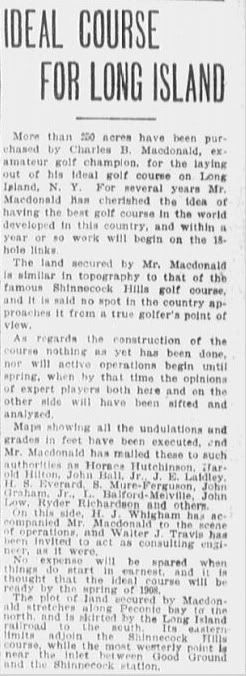
Here again is the Oct. 16, 1906 Boston Globe article, which was posted a few pages back.
It also notes that CBM made his third trip abroad sometime in 1906 to "finalize his research" which sounds like making the last of his hole notes, etc., but we can't be sure.
CBM and HJW's trip overseas in 1906 is well documented on this site and elsewhere.
David,
First, thanks for the answers. Second, I think we can all be accused of not following along, or at least missing the point of several posts. While I have made my mistakes, too, surely your non answers to Mike fit the bill. Mike is quoting CBM directly in those Dec 1906 articles, and it seems pretty straightforward.
As to your October article, thanks again. However, I read that as the topo maps have been prepared but the design work hasn't really started. I would agree that CBM and HJW had made their three day ride by then, and had identified the Alps, Redan, Short, etc. However, most of the articles repeat those little snippets, and say no more. All the comments about design work are that the topo maps have been sent to others, and others will be brought in (note the future tense).
I don't see how you can read it any differently, other than to force your interpretation on it. I have forgotten what other corroborating documents you use to support your theory, but this one seems pretty weak and does not appear to say what you have told us it said. What I can believe is that after the ride sometime in the summer of 1906, CBM or SHPB did hire a surveyor to map the topo. How long do we think that took? In that thicket, maybe a few months? Was CBM working on this every day or week, or did his real job keep this more of hobby secondary avocation that made it take longer than we think it should?
I agree with you that some very basic planning took place in 1906, enough to determine that this was the general land they wanted, and picking some of the holes. It just doesn't appear to me that they got as far as you think they did, which is an honest disagreement of opinion based on sometimes muddled documentation.
In Dec. 1906, CBM says they will start the hard work of finalizing the routing. Again, Mike twisted absolutely nothing, he read it direct for what it said - that the holes will be selected and routing finalized in the next 5 months. Again, I have a hard time putting any other interpretation to it other than to read it for exactly what CBM says.
I can tell you from walking many routings in the woods that connecting natural features you want to use is not a fast process. For example, they wanted to use the hills for the Alps on current hole 3. And, the presumably felt it ought to be a par 4 of certain length. What if they found what they thought was a great tee, but got back to the maps only to find it was 505 yard par 5? Well, they shorten the tee, but then what to do with 2 green, and what hole should be copied with a hole of that new length, etc. I can see exactly why he said they were going to decide on hole lengths and features to copy in that time period. In other words, the 9th inning in a baseball game counts just as much as the 1st inning to the outcome.
I believe you think routing was quicker and easier in those days, and for some, it probably was (Bendelow in his Spalding days) but not for someone laying out an ideal course and a life dream. As far as compared to today, I can only imagine that kind of project would be slower, given lesser technology, horses instead of Cushman carts, etc. How quickly could all the players come together on the same weekend (or day off) to ride the routing and make changes as a group?
I also believe the Dec 1906 snippet says that the boundaries will not be surveyed until the final design is done. This five month period is clearly when the wiggle room that was left to later had to be decided and nailed down to the nut. I can't see it being done sooner. And, if the boundaries of this theoretical golf course routing had not been settled and surveyed, it would be hard for CBM to know how many acres he use, right? And certainly the final adjustments had to be made to get to the agreed upon 205 acres he wanted.
BTW, I am not so sure the eastern border was locked, was it? I don't know the boundaries well, but do know that SH didn't own the northern land next to NGLA 10 until later. Who owned the land until then? Was it SHPB or another entity?
And as to May 1907, I believe Raynor was hired to lay the golf course out on the property and Payne hired to build it as he built SH, but then again, that little bit has nothing to do with the timeline we are debating.....I think Raynor was brought on several months before Payne for that work.