News:

This discussion group is best enjoyed using Google Chrome, Firefox or Safari.


JESII

  • Karma: +0/-0
Re: Pine Valley and Topos
« Reply #1625 on: October 28, 2011, 10:31:55 AM »
Wouldn't the fact that the border of the pond is a dotted line support Bryan's assertion that it was not yet built? This was their planned fill point...


David,

Regarding the "abrupt" drop from the third tee versus the sixth fairway, while the topo may not look like it, there is a very distinct sharp rise from the second fairway up the top of th eridge. It gives the impression of a wall. From about 30 yards to the front edge of the green you climb 20 or 25 feet. This same (or very similar) feature extends across the ridge line from the woods East of the course to the woods West of the fourth hole. It's possible the gradual slope presented in the topos was graded into the current form all the way across there, I don't know. The drop from six would look more like falling off a mountain, much like the JAB picture does.

Patrick_Mucci

Re: Pine Valley and Topos
« Reply #1626 on: October 28, 2011, 11:52:55 PM »
Bryan,

I think you're making a huge mistake in claiming that the pond, as you call it, wasn't there, based on your interpretation of the use of language from the article you cite.

I don't believe I ever considered that waterway a "pond".

I don't know many that do.

I do consider it a creek in the same fashion as I view the waterway fronting the 12th at Augusta as a creek, not a pond.

They're very similar in dimension and configuration.

Yet, NO ONE calls that waterway, "RAE'S POND", they call it "Rae's Creek"

As TEPaul stated, your lack of familiarity with the property and its features is causing you to draw flawed conclusions.

I don't consider the waterway fronting the 18th green a pond either.

To state that the waterway wasn't there, based upon your interpretation of AWT's use of words, without seeing the waterway and understanding the context of the use of the word, "creek" seems shakey at best.

I think the Augusta, "Rae's Creek" analogy at the 12th hole proves the point.

JESII

  • Karma: +0/-0
Re: Pine Valley and Topos
« Reply #1627 on: October 29, 2011, 12:44:42 AM »
Bryan,

I think you're making a huge mistake in claiming that the pond, as you call it, wasn't there, based on your interpretation of the use of language from the article you cite.

I don't believe I ever considered that waterway a "pond".

I don't know many that do.

I do consider it a creek in the same fashion as I view the waterway fronting the 12th at Augusta as a creek, not a pond.


Really???

How about the TOPO using the word "POND"?

Bryan Izatt

  • Karma: +0/-0
Re: Pine Valley and Topos
« Reply #1628 on: October 29, 2011, 02:47:10 AM »
Bryan, those are the maps I am using, plus google earth.   I haven't done an overlay, but one can look at the location of the road and some of the other features (the ravine) and tell that the ridge elevation doesn't match up.   Do you disagree?

I've tried to overlay both the 1898 topo and the modern NJ Atlas topo.  I don't think it can effectively be done, but why don't you give it a try.  I'd say based on eyeballing it that the 1898 topo doesn't match at all well.  The modern topo is not too far off, but it's difficult to say because of the distortion of the 1913 topo I cleaned up.

As for the creek vs. the pond issue, if the pond is shown on a topo dated March of 1913, I am inclined to think there was a pond there then, despite what Tillinghast might have called it.   Who knows, maybe Tillinghast thought the hole would cross below the dam?

The 1898 topo shows a creek.  The 1913 topo shows a creek at the top end, presumably from the springs.  If they had converted the creek to a pond by March 1913, when would they have done that?  Between November and March?  How would they have done it?  Just throw up a dam and wait for it to fill up?  Excavate the bottom to create the pond?  Maybe we could get Pat and Tom out there in a canoe and plumb the bottom to see how deep it is.  Would they have had to line the bottom with clay.  Why wouldn't the water just percolate through the underlying sand and the pond not fill up?  I fail to see how all that engineering work could be done in 4 months over the winter.  Rather than considering Tillinghast to always be wrong, why don't we assume that he knew the difference between a pond and a creek.

I would assume that Crump had this map around the time of the date, but the date on a contour map does not necessarily reflect the date of the survey.  For example, NJ began a survey in the 1880, and they were still producing contour maps based at least in part on that survey for many decades thereafter.

Now you're being silly.  What does the timeline of a state level survey and the publication of state contour maps have to do with this situation.  Crump bought the land in the fall.  Presumably he commissioned the surveyor shortly thereafter.  Why would there be any significant delay in delivering the map.  Presumably Crump wanted the map and the surveyor wanted to get paid.   

Bryan Izatt

  • Karma: +0/-0
Re: Pine Valley and Topos
« Reply #1629 on: October 29, 2011, 03:02:49 AM »
Patrick,

What does your 21st century consideration of that waterway have to do with anything.  Tillinghast said it was a creek.  Crump's surveyor said it was a pond. Seems hard to believe that two contemporaneous knowledgeable people would use distinctly different terms to describe the same feature.  It was a creek before Crump got there, and it was dammed and became a pond sometime during the protracted building of the course.  The logical explanation is that Tillinghast saw it early on as a creek, and the surveyor drew it and labelled it as a pond because that was what Crump told him he wanted to put there.

You're the one making the huge mistake with your 21st century considerations and faulty analogies.

P.S.  When Rae's Creek was named, it was a creek.  Was it labelled a pond on the first drawings of Augusta?

P.P.S.  Analogies never prove a point.

P.P.P.S.  You don't need to argue every point. 

 
Bryan,

I think you're making a huge mistake in claiming that the pond, as you call it, wasn't there, based on your interpretation of the use of language from the article you cite.

I don't believe I ever considered that waterway a "pond".

I don't know many that do.

I do consider it a creek in the same fashion as I view the waterway fronting the 12th at Augusta as a creek, not a pond.

They're very similar in dimension and configuration.

Yet, NO ONE calls that waterway, "RAE'S POND", they call it "Rae's Creek"

As TEPaul stated, your lack of familiarity with the property and its features is causing you to draw flawed conclusions.

I don't consider the waterway fronting the 18th green a pond either.

To state that the waterway wasn't there, based upon your interpretation of AWT's use of words, without seeing the waterway and understanding the context of the use of the word, "creek" seems shakey at best.

I think the Augusta, "Rae's Creek" analogy at the 12th hole proves the point.

Paul_Turner

  • Karma: +0/-0
Re: Pine Valley and Topos
« Reply #1630 on: October 29, 2011, 08:11:12 AM »
I think this 1920 aerial shows the creek in its natural meandering state.  It was flooded to make the pond (see 1915 photos of the 5th) and then drained for some reason.

can't get to heaven with a three chord song

Patrick_Mucci

Re: Pine Valley and Topos
« Reply #1631 on: October 29, 2011, 12:52:23 PM »
Patrick,

What does your 21st century consideration of that waterway have to do with anything. 

I believe that Augusta was designed and built in the 20th century, the same century that Pine Valley was designed and built.


Tillinghast said it was a creek.  Crump's surveyor said it was a pond.
Seems hard to believe that two contemporaneous knowledgeable people would use distinctly different terms to describe the same feature.
Not really.
And Crump's surveyor didn't just say it was a pond, he defined its boundaries.
Just like you alleged that he clearly defined the forestation.
You can't have it both ways.
And, you wouldn't make that statement if you were familiar with the site
 

It was a creek before Crump got there, and it was dammed and became a pond sometime during the protracted building of the course. 

You don't know that, that's pure speculation on your part.
How do you know that it wasn't dammed prior to the building of the course ?
The Contour Map is dated March 1913.
How could the surveyor have determined the boundaries of the pond prior to it's creation ?

Is that what surveyors do, read the minds or listen to the developers and create "forward looking" contour maps with features that don't exist ?

If the Lumberton mining company owned the land prior to Crump, perhaps they dammed the creek for their water needs.


The logical explanation is that Tillinghast saw it early on as a creek, and the surveyor drew it and labelled it as a pond because that was what Crump told him he wanted to put there.

Is that what surveyors do, read the minds or listen to the developers and create "forward looking" contour maps with features that don't exist ?

How would the surveyor know where to define the boundaries of the lake ?  Especially if the routing hadn't been established yet ?
And, if you recall, the original 5th hole isn't the same hole that exists today, it was Colt who designed the final hole in May/June of 1913, months after the contour map had been created.

Your establishment of the date, based upon your interpretation of word usage, is deeply flawed.
It's purely conjecture and speculation on your part, absent any substantiating facts.


You're the one making the huge mistake with your 21st century considerations and faulty analogies.

I think you'll find that Rae's Creek existed and was so named in the 20th century, the same century that Pine Valley was created.


P.S.  When Rae's Creek was named, it was a creek. 

That's very observant of you, but, the question is, what constitutes a creek.
Creeks are wider than streams, narrower than lakes and have flow.
Creeks aren't of the same universal width, they expand and contract in their linear form.


Was it labelled a pond on the first drawings of Augusta?

Rae's Creek appears on the 1932 topo, one of the first drawings of ANGC and is not identified as Rae's Creek.


P.P.S.  Analogies never prove a point.

Like your 21st century versus 20th century analysis ?


P.P.P.S.  You don't need to argue every point.

I do when you or others present flawed data and/or flawed conclusions, such as the basis for your conclusion regarding the waterway at Pine Valley, a waterway which you've never seen in person.

Why should I let, what I perceive as errors or flaws, go unchallenged ?
Is that how you get to the truth, by allowing misinformation to be accepted as fact ?

One would think, if we're trying to piece together the chain of chronological events, that there should be a premium on accuracy, and not speculation when it comes to drawing conclusions.

And, I don't think your refutation of the Surveyor's contour map, based soley on your interpretation of Tillinghast's use of words is correct.

Surveyors are trained professionals, mostly civil engineers.
They are not prone to creating contour maps and incorporating features that don't exist as of the date of their suvey.
That would be a material misrepresentation and contrary to their professional standards.

Features not in existance at the time of a survey, but planned in the future, are identified as such by the surveyor, if that's one of the purposes of the survey, which in the case of the 1913 survey it wasn't.

You don't mind challenging me when you think I might be incorrect, so you should accept challenges from others when they don't think you're correct.
 

Bryan,

I think you're making a huge mistake in claiming that the pond, as you call it, wasn't there, based on your interpretation of the use of language from the article you cite.

I don't believe I ever considered that waterway a "pond".

I don't know many that do.

I do consider it a creek in the same fashion as I view the waterway fronting the 12th at Augusta as a creek, not a pond.

They're very similar in dimension and configuration.

Yet, NO ONE calls that waterway, "RAE'S POND", they call it "Rae's Creek"

As TEPaul stated, your lack of familiarity with the property and its features is causing you to draw flawed conclusions.

I don't consider the waterway fronting the 18th green a pond either.

To state that the waterway wasn't there, based upon your interpretation of AWT's use of words, without seeing the waterway and understanding the context of the use of the word, "creek" seems shakey at best.

I think the Augusta, "Rae's Creek" analogy at the 12th hole proves the point.

Patrick_Mucci

Re: Pine Valley and Topos
« Reply #1632 on: October 29, 2011, 01:00:33 PM »
Paul Turner,

I've seen many waterways, ponds, lakes, etc., etc. drained.

Invariably, they have that same feature, a channel, usually the lowest lying depresson, that the water flows through.

I don't know that that feature, as pictured in your photo, depicts the original creek, as opposed to the channel that gets created when a body of water is drained.

Those channels tend to be more linear in nature, like the one pictured above.

JESII

  • Karma: +0/-0
Re: Pine Valley and Topos
« Reply #1633 on: October 29, 2011, 01:51:34 PM »


Pat,

This article was apparently from January 1914, I think it addresses the creek/lake discussion well.

DMoriarty

  • Karma: +0/-0
Re: Pine Valley and Topos
« Reply #1634 on: October 29, 2011, 05:36:40 PM »
I've tried to overlay both the 1898 topo and the modern NJ Atlas topo.  I don't think it can effectively be done, but why don't you give it a try.  I'd say based on eyeballing it that the 1898 topo doesn't match at all well.  The modern topo is not too far off, but it's difficult to say because of the distortion of the 1913 topo I cleaned up.

Bryan, I haven't tried nor do I care to.  I trust you when you say it can't effectively be done.  Nonetheless we can read the respective tops without doing a precise overlay.  

I am confused as to how you can say the modern topo is not far off from the Crump topo.  Here is an overlay of the course and the USGS topo, from the NJ Aerials website.  As you can see the highpoint of the 6th fairway is 164 ft, which is about what Google Earth comes up with, and the green is at 170+ which again is what Google Earth comes up with.  In contrast, your cleaned-up  Crump topo has the entire fairway at over 170 ft, portions at 175+, and the green at 180+.  Not all that close as topos go.  

As for the creek vs. the pond issue, if the pond is shown on a topo dated March of 1913, I am inclined to think there was a pond there then, despite what Tillinghast might have called it.   Who knows, maybe Tillinghast thought the hole would cross below the dam?

Quote
The 1898 topo shows a creek.  The 1913 topo shows a creek at the top end, presumably from the springs.  If they had converted the creek to a pond by March 1913, when would they have done that?  Between November and March?  How would they have done it?  Just throw up a dam and wait for it to fill up?  Excavate the bottom to create the pond?  Maybe we could get Pat and Tom out there in a canoe and plumb the bottom to see how deep it is.  Would they have had to line the bottom with clay.  Why wouldn't the water just percolate through the underlying sand and the pond not fill up?  I fail to see how all that engineering work could be done in 4 months over the winter.  Rather than considering Tillinghast to always be wrong, why don't we assume that he knew the difference between a pond and a creek.

Not sure why you are trying to make this about Tillinghast?  I've no interest in maligning Tillinghast or anyone else, so let's not pretend otherwise.  It looks to me like the creator of the map drew in a pond and and marked it "Pond," and drew a dam and marked it "Dam."   Am I misreading that?  Do you think the pond was drawn later?   If so, how did you reach that conclusion?  If not, do you think the map maker was hired to do a topo but thought he'd throw in a post construction rendering of a pond?  That'd be a bit strange, don't you think?  Did they tell him to add in a model for the pond, but nothing else-- not tees, greens, or even roads? Is it possible that there was some semblance of a pond there, even a seasonal pond, and they added to it later?

If there was some semblance of a pond, it could have been created anytime after the 1880's survey took place.

Quote
Now you're being silly.  What does the timeline of a state level survey and the publication of state contour maps have to do with this situation.  Crump bought the land in the fall.  Presumably he commissioned the surveyor shortly thereafter.  Why would there be any significant delay in delivering the map.  Presumably Crump wanted the map and the surveyor wanted to get paid.

Again, Bryan no need to get snippy.  I don't doubt that Crump had the map in March.  My point was that the date on the map doesn't necessarily reflect the date of the survey.  Do we know that Crump commissioned an actual original survey?  I don't recall.  If we do not know, then it raises the possibility that that map was created using prior survey data, date unknown.
__________________________________________________

Jim,

I don't see the same things in those old pics as you do.  For example, I don't see anything that looks like "falling off a mountain" like you see in the Brown pic, and while I understand what you mean about a "wall" from the photos of the hole, I don't see anything like that in the pic with the man.

I really don't know what else to say about it except that I am not convinced and I don't think the geometry makes any sense at all.  Probably I am wrong --I have never been there so what the hell do I know?   But with what little I know, I cannot make sense out of either caption.  

As for the article you posted,  how does it address the timing of the creation of the pond?   Is it possible there was some semblance of a pond or swamp there, and it was expanded during construction?
_____________________________________________________

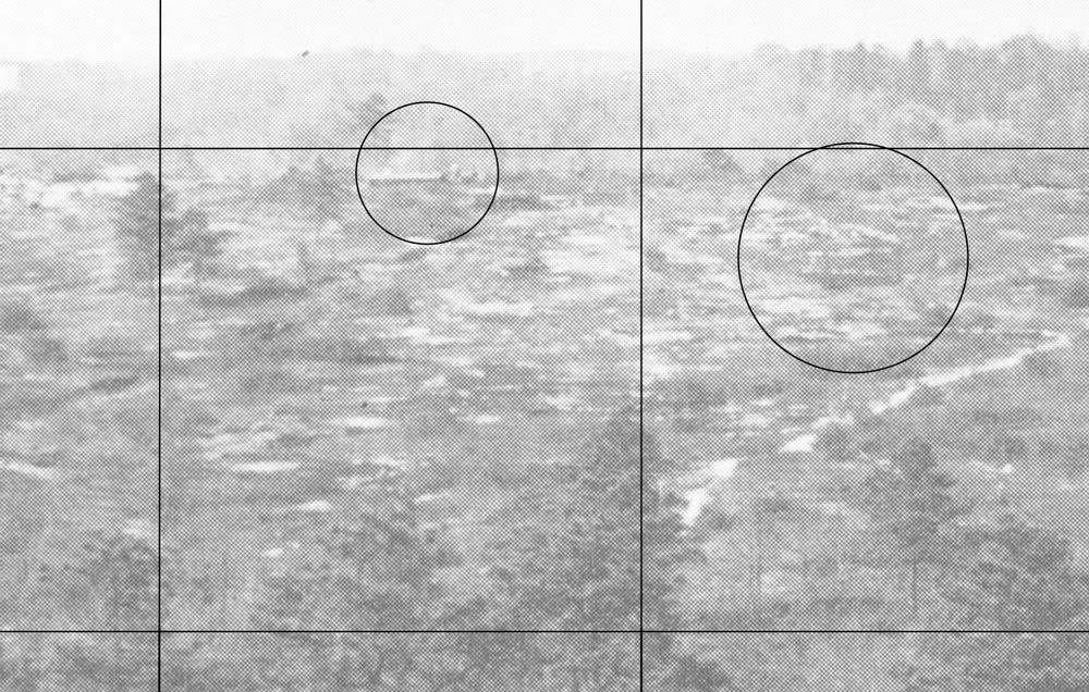
I mentioned that there was quite a bit in the blowup, ranging from interesting to strange.  Here is a section with a bit of both.   In the first circle there appears to be a low structure with possibly some other structure (tanks or something) behind next to it, or behind.  There appear to be some dunes, mounds, or piles around these structures.   I have no idea what to make of what looks to be in the second circle.   I also see a few more roads or trails, including a fairly large one running at a diagonal, touching the bottom of the first circle.   I also see what may be another structure in between the circles but I am not sure.  


« Last Edit: October 29, 2011, 05:41:14 PM by DMoriarty »
Golf history can be quite interesting if you just let your favorite legends go and allow the truth to take you where it will.
--Tom MacWood (1958-2012)

Paul_Turner

  • Karma: +0/-0
Re: Pine Valley and Topos
« Reply #1635 on: October 29, 2011, 08:16:43 PM »
Patrick

It doesn't look like a linear channel to me.  Looks like a meandering creek/stream with lots of twists and turns.
can't get to heaven with a three chord song

Bryan Izatt

  • Karma: +0/-0
Re: Pine Valley and Topos
« Reply #1636 on: October 29, 2011, 10:57:18 PM »
Patrick,

Please tell me what "flawed data" I have provided.

As to flawed conclusions, that is a matter of perspective.

What kind of boats navigate on your waterway - a waterway being a navigable body of water?

Perhaps you should look up "linear".  The creek bed in Paul's picture is the antithesis of linear.

The January 1914 Philadelphia Inquirer article says that three dams were built to create the ponds.  Do you have any evidence that Lumberton built them, or is this just another example of any idea being better than the obvious one? 

Bryan Izatt

  • Karma: +0/-0
Re: Pine Valley and Topos
« Reply #1637 on: October 30, 2011, 12:19:40 AM »
David,

When I said it wasn't far off the modern topo, I meant that features like ridges, noses and ravines are about where expected.  The actual elevation of the features is not precisely the same nor is the shape.  Hope that clears up your confusion.

As more mindless speculation, do you suppose that there has bee some grading done between then and now.  Might they have cut off some high points to fill lower spots, for example.

I am more inclined to think that Crump told the surveyor that he was going to put a dam there and to draw it on the plan.  Or, Crump drew the pond outline himself on the contour map, if the mapper only did contour lines.  Figuring out the the pond outline would be easy if you knew how high the dam was going to be. 

Did Crump commission the survey?  Well it's in 5 foot contours.  The USGS only had 10 foot contour maps.  Who else would have surveyed that property at 5 foot intervals?  Anything is possible, I guess. 

The contour map is labelled "Plan Showing Topographical Survey of PROPERTY OF GEO. A. CRUMP  Sumner Camden County NJ.  It's called a "Plan".  That could include future features that Crump wanted.  It is specifically for the property of Geo. A. Crump, not someone else.  Do you know of another 5 foot contour survey that could have been the source if the mapper/surveyor didn't do it specifically for Crump?  I am inclined to the simple answer - Crump commissioned it and it was done specifically for him.  And, I am inclined to think it was a plan.

I think the pond is on the map, either because Crump drew it, or instructed the mapper to draw it.  By March they were pretty far along with clearing, so they must have had some idea of the plan, including whether there would be a pond.  The Tillinghast article and the Philadelphia article both suggest that the dam and the pond came after March 1913, in my opinion.  Are they proof beyond a shadow of a doubt?  No.  Is it the most logical conclusion.  I think so.  Much of your Merion treatise is based on similar analysis.  Why is it so hard to accept here? 

JESII

  • Karma: +0/-0
Re: Pine Valley and Topos
« Reply #1638 on: October 30, 2011, 05:40:10 PM »
David,

What do you think those strctures, and any additional road you may see, mean? If this picture was from the clearing phase (not sure if we know this as fact or not) then they would surely be from previous ownership, no?

Also, wouldn't the dotted line border of the pond indicate it was not fixed? The borders of some areas that were cleared and replanted are marked with dotted lines.

DMoriarty

  • Karma: +0/-0
Re: Pine Valley and Topos
« Reply #1639 on: October 30, 2011, 07:44:35 PM »
Bryan,  I am inclined to think the survey was conducted for Crump also.   Just asking whether we know that for sure, and mentioning the possibility that it was not.   Not sure we can attach and special significance to the word "plan" in the title.   Aren't we in agreement that the course was drawn on the topo?

As for why the "POND" and "DAM" are on the map, I think the simplest and most straight forward answer is that the Pond and Dam were there at the time the topo was created. There weren't three dams or a larger pond like the article describes, but I cannot imagine why they'd draw a pond if one wasn't there.  If nothing else having the real contours would have helped them plan and build the pond!   And I doubt very much that Crump drew in the pond.  If he had we'd see the contours to the bottom of the pond and we do not.

And I'd be very surprised if they graded approx. 10 feet off much of the 6th fairway and green prior to seeding. First , it doesn't look like the older topo matched the Crump topo either.  Second, why would they?  They were quite proud of the tall ridge, and it looks close to flat enough for a fairway on the Crump topo, doesn't it?  I could see them shaping a bit, but to take the whole fairway down that much?  Seems unlikely.  Obviously someone who has been there would be a better judge.  Perhaps Patrick and or Jim could fill us in on whether they seem to have taken off a significant portion of the ridge to make the fairway?

Not sure why you occasionally bring up my Merion essay.  I would think you wouldn't want to get into it, and I know I'd rather not.  But I will mention that I somewhat disagree with your characterization.  As far as what is most logical in this circumstance I am not sure how you can look at a topo with a "POND" and a "DAM" and come away thinking that when it was drawn, there was no pond or dam.  But then I doubt it matters one way or another anyway.   

Here is the overlay I mentioned.  I forgot to post it above.    As you can see, the elevation is 150+ almost all the way across the 4th fairway.  That would block most of what we see of the far hills and that isn't the case in the photos.  You asked me how much of the hillside I think we see behind, and it is difficult to say exactly, but we do see is multiple tree heights high.  That is way to much.   

 
_________________________________________________________

No comments on what looks like a low slung building in the photo, or on the strange structure in the other circle, on on the apparent roads? 

_________________________________________________________

David,

What do you think those strctures, and any additional road you may see, mean? If this picture was from the clearing phase (not sure if we know this as fact or not) then they would surely be from previous ownership, no?

I don't know.  Not sure there was a single clearing phase.  The May 1913 AWT article makes it sound like they had cleared holes 1-6 and possibly 18.   They prepared 11 holes that first year didn't they?   Was the entire property cleared initially?  I don't know.   

As for what they mean, it is hard to tell. If we knew the locations of old structures then they might help identify the camera angle(s).  If we could identify old commonly used roads, that would help too. 

Also, if we are indeed looking at an low slung building and surrounding structures in that first photo (I think we are) then I think we need to reexamine some assumptions we have been making about the distances and/or the angle of vision of the camera.  I would think a building at 400 yards would appear larger than that if Bryan's assumption of a 30-40 degree angle of vision is correct.  Right Bryan? 

Quote
Also, wouldn't the dotted line border of the pond indicate it was not fixed? The borders of some areas that were cleared and replanted are marked with dotted lines.

It could be, but that leaves me wondering why the contour lines don't continue into the "POND."  Also, there are trees around the pond but not in the pond.   Are we to believe that there were no trees growing there?  Or were they already cut in anticipation of the pond?  Or was it already a pond?   

One of the books mentions that they had some early concern about water. Perhaps they built some sort of a dam right at the beginning, to assure at least a temporary source of water, and then formalized it later.   

Does it really matter whether it was a pond or a creek in March of 1913? 
Golf history can be quite interesting if you just let your favorite legends go and allow the truth to take you where it will.
--Tom MacWood (1958-2012)

DMoriarty

  • Karma: +0/-0
Re: Pine Valley and Topos
« Reply #1640 on: October 30, 2011, 10:16:40 PM »
And then there is this . . .


From the Brown book, with the caption: "Example of terrain cleared for fairway construction.

But the same photo is in the Shelly book, only with a different caption:  "Creativity at work!  Lower left, the 3rd green; upper left, 4th fairway; upper far right 6th fairway.

The photo of cleared terrain for fairway construction is also a photo of of the 3rd green with the 4th fairway and the 6th fairway in the background?   Maybe I am missing something.  If so, then can someone explain how we can see the 4th fairway and the 6th fairway, but not ravine in between them?   Thanks.
Golf history can be quite interesting if you just let your favorite legends go and allow the truth to take you where it will.
--Tom MacWood (1958-2012)

Bryan Izatt

  • Karma: +0/-0
Re: Pine Valley and Topos
« Reply #1641 on: November 02, 2011, 12:26:10 PM »
David,

Re the first picture, I can't really say that the artifacts you've circled look like anything in particular to me.

Re the other picture, I agree that it is hard to imagine where the camera position would be to match the description in the caption.  Would it help if the caption said 3rd green in the lower right, rather than lower left?

Here's the picture, followed by one of the 3rd hole from 1915 from Golf Illustrated.  The land forms look similar.  If the third green was indeed off the right edge of the picture, as in the third picture below, then it makes some sense of where the the first picture was taken.  Perhaps the caption writer and whoever took the photos just didn't have a good sense of what they were looking, when nothing was there, compared to where the various holes ended up when the course was completed.


DMoriarty

  • Karma: +0/-0
Re: Pine Valley and Topos
« Reply #1642 on: November 02, 2011, 01:41:19 PM »
David,

Re the first picture, I can't really say that the artifacts you've circled look like anything in particular to me.

Really?  You don't see anything in particular in the circle below, other than a photographic artifact?  Nothing that looks like it could be a low slung building?  Are you sure about that?  What exactly do you mean when you use the term "artifact?"


I cannot say with absolute certainty at what we are looking, but characterizing it as nothing but a photographic "artifact" and ignoring it on that basis would take a much larger leap of faith on my part than considering the possibility that we actually are seeing something of some relevance.  
______________________________________

As for the two pictures you posted,  I hadn't considered that angle, because the angle in the photo of the 3rd green seems between 90 and 180 degrees off from the caption.  That said, the photos could be a match, although I am not sure that the two low, indented areas on the opposite ridge match the ridge on which the 6th fairway sits, and I am not the foreground matches how the ground apparently drops off behind the third green and then rises up again on the ridge.

Problem is, if it is a match, everything in the caption is wrong.  The 3rd green is not in the lower left.  The 4th fairway is not in the "upper left" at all.   And the 6th fairway is not in the "upper far right," but stretched across the entire upper portion of the photo.  

Quote
Re the other picture, I agree that it is hard to imagine where the camera position would be to match the description in the caption.  Would it help if the caption said 3rd green in the lower right, rather than lower left?

No I don't think that would "help," because that is not what the caption says.  I am not sure I understand your methodology here. Sometimes you give weight to these captions, and sometimes you alter them as  you see fit.   Oftentimes you do both at the same time. Can you explain what purpose the captions serve? How do the captions help us understand what really happened if we have to rewrite each caption to get it to make any sense at all?  

Maybe you and I are focusing on different things . . . For me, key questions are whether the authors of these captions had some guidance from additional contemporaneous sources as to what we are seeing in these photos, or whether they were merely trying to figure out what these pictures show, same as we are? If the former, then I am inclined to give the captions much greater weight than if the latter. But if they were just trying to figure things out the same as us, then that radically changes my view of the reliability of the captions.  

Aren't you just writing your own captions, yet treating them as if they are somehow based on the captions for the books?

If we have to continually fudge the captions to make them work, then why (and how) are we bound by them in the first place?
« Last Edit: November 02, 2011, 01:45:17 PM by DMoriarty »
Golf history can be quite interesting if you just let your favorite legends go and allow the truth to take you where it will.
--Tom MacWood (1958-2012)

JESII

  • Karma: +0/-0
Re: Pine Valley and Topos
« Reply #1643 on: November 02, 2011, 03:51:27 PM »
Do we have an appoximate date for the picture labeled "from the 6th hole looking across 4 to 3 and 2"? How about the one of 3 green 4 fairway and 6 fairway? Were these pictures posted in a magazine article from the very beginning of the construction? Or were they not seen until the JAB book came out?

DMoriarty

  • Karma: +0/-0
Re: Pine Valley and Topos
« Reply #1644 on: November 02, 2011, 07:27:41 PM »
Do we have an appoximate date for the picture labeled "from the 6th hole looking across 4 to 3 and 2"? How about the one of 3 green 4 fairway and 6 fairway? Were these pictures posted in a magazine article from the very beginning of the construction? Or were they not seen until the JAB book came out?

The photo supposedly from the third tee was published in May 1913,  but I have not seen the other two photos (the two you describe) in any magazine articles.

The caption about the 3rd green, 4th fairway, and 6th fairway photo is from the Shelly book.   The photo also appeared in the earlier Brown book, but with the caption: "Example of terrain cleared for fairway construction."   So between the Brown book and the Shelly book, the caption got quite a bit more detailed.  
__________________________________________________

Bryan, on an unrelated project I have been doing some research on photographers from this era, and as near as I can tell the most popular camera for photojournalism-type photography during this time period was an early SLR camera, the Graflex "Press" utilizing a 5" x 7" negative.  (I had thought this camera did not come into existence until later, but was wrong about this.)  This was sold without a lens but reportedly fit lenses with a focal length from seven inches to fourteen inches.  Most of the examples I have found seem to have focal lengths of seven to nine inches, with the longer lenses used for subjects requiring a narrow angle like wildlife shot at distance.  For that camera, a lens with a focal length of 9 inches would produce a horizontal viewing angle of 42.7 degrees, and a lens with a focal length of seven inches would produce a horizontal viewing angle of 53.1 degrees.

I have a book about a photographer (Evelyn Cameron) from this era. She reportedly used a Graflex 5x7 from around 1905, and a lens with a focal length of 9 inches. While it is difficult to say without measuring the subject matter, I'd guess that the photos in question (at least the main one from the ridge) had a similar or slightly wider angle of view to her photos, so based on this I'd guess the angle of view was in this range.
« Last Edit: November 02, 2011, 07:54:33 PM by DMoriarty »
Golf history can be quite interesting if you just let your favorite legends go and allow the truth to take you where it will.
--Tom MacWood (1958-2012)

JESII

  • Karma: +0/-0
Re: Pine Valley and Topos
« Reply #1645 on: November 02, 2011, 07:32:35 PM »
Thanks David.


Bryan Izatt

  • Karma: +0/-0
Re: Pine Valley and Topos
« Reply #1646 on: November 02, 2011, 11:47:19 PM »
David,

Re the first picture, I can't really say that the artifacts you've circled look like anything in particular to me.

Really?  You don't see anything in particular in the circle below, other than a photographic artifact?  Nothing that looks like it could be a low slung building?  Are you sure about that?  What exactly do you mean when you use the term "artifact?"

Let me restate this for you to make my intent clearer:


Re the first picture, I can't really say that the things you've circled look like anything that I can identify.


If you are referring to the horizontal, light on top, dark on the bottom, rectangular thing, then no it does not really look like anything that I can positively identify.  If you think it is a low slung building, then it must have been a very low building.  It is, what, about 1/12th of the height of the tree on its immediate left.  That would make it 3 to 7 feet tall depending on how tall you think the trees are.  Did they make buildings with flat roofs in those days?  I could speculate about many other things it could be, but what would be the point.  It doesn't look like anything I can positively identify.  Suppose you are right and it is a low slung building.  What do you think that means?


I cannot say with absolute certainty at what we are looking, but characterizing it as nothing but a photographic "artifact" and ignoring it on that basis would take a much larger leap of faith on my part than considering the possibility that we actually are seeing something of some relevance.

You see it.  You think it is a low slung building.  What is the relevance?  I don't have an alternative hypothesis as to what the "thing" is.
______________________________________

As for the two pictures you posted,  I hadn't considered that angle, because the angle in the photo of the 3rd green seems between 90 and 180 degrees off from the caption.  That said, the photos could be a match, although I am not sure that the two low, indented areas on the opposite ridge match the ridge on which the 6th fairway sits, and I am not the foreground matches how the ground apparently drops off behind the third green and then rises up again on the ridge.

I posed it as a possibility. If you can debunk it, I wouldn't be surprised.  I thought the sloping ground, height of the ridge, and the odd trees poking up looked similar, but in no way is that definitive.

Problem is, if it is a match, everything in the caption is wrong.  The 3rd green is not in the lower left.  The 4th fairway is not in the "upper left" at all.   And the 6th fairway is not in the "upper far right," but stretched across the entire upper portion of the photo.

I agree.  If it happened that the photo is as I've placed it, then the entire caption must be wrong.

Quote
Re the other picture, I agree that it is hard to imagine where the camera position would be to match the description in the caption.  Would it help if the caption said 3rd green in the lower right, rather than lower left?

No I don't think that would "help," because that is not what the caption says.  I am not sure I understand your methodology here. Sometimes you give weight to these captions, and sometimes you alter them as  you see fit.   Oftentimes you do both at the same time. Can you explain what purpose the captions serve? How do the captions help us understand what really happened if we have to rewrite each caption to get it to make any sense at all?

As I see it, there are three options around the captions:

a) They are exactly correct.

b) They are completely wrong.

c)  They are partially right and partially wrong.

As I look at the pictures and try to figure them out, my view changes between a, b, and c as I think about it and new inputs, like yours, arrive.  I suppose if we could ever agree on where the picture was taken from and what it shows, then I would finally know whether the captions fall into category a, b, or c.

If the caption is correct, then the photo may have been taken from a point near the one in the aerial below.  The third green is then on the lower left, the 6th fairway on the upper right. But, then the 4th fairway isn't on the upper left. At best it would be on the middle left.


So, rather than confusing you with my "methodology" (whatever you think it is), why don't you tell us what the picture is of, and where it was taken from, and we can go from there.  As a starting point, do you think it is a picture from Pine Valley?
 

Maybe you and I are focusing on different things . . . For me, key questions are whether the authors of these captions had some guidance from additional contemporaneous sources as to what we are seeing in these photos, or whether they were merely trying to figure out what these pictures show, same as we are? If the former, then I am inclined to give the captions much greater weight than if the latter. But if they were just trying to figure things out the same as us, then that radically changes my view of the reliability of the captions.

So, do you know which is true?  If not, then what weight do we put on the captions vs our own photo interpretation?  I guess I didn't state my first (tentative) conclusion.  I don't think that the 4th fairway can be upper left if the 3rd green is lower left.  The picture makes no sense that way, in my opinion.  Do you agree/disagree?

An off-line source suggests that the the captions are based on inscriptions from the back of the photos.  But, then you generally don't believe this off-line source. 


Aren't you just writing your own captions, yet treating them as if they are somehow based on the captions for the books?

No, I wasn't trying to do that.

If we have to continually fudge the captions to make them work, then why (and how) are we bound by them in the first place?

I don't feel particularly bound to them.  Do you?


Bryan Izatt

  • Karma: +0/-0
Re: Pine Valley and Topos
« Reply #1647 on: November 02, 2011, 11:56:19 PM »
David,

Re the Graflex SLR camera, I guess it is a possibility.  I had read that the SLR's of that era weren't very good and were finicky.  I wonder who took the pictures.  If it was Crump, or one of the crew, then I think the Graflex SLR might have been a bit of a stretch in the field.  If it was a professional photographer, then it might be more likely.   

DMoriarty

  • Karma: +0/-0
Re: Pine Valley and Topos
« Reply #1648 on: November 03, 2011, 02:32:12 AM »
Bryan,

I find it fascinating that you can identify a specific "tree" and its exact location, yet you cannot see what looks like a structure to me.  Not only that, but you've added a flat roof to the structure and even estimated the height of the structure you don't see.  I see a structure, but it looks like an angled roof to me, and it looks like it is partially behind a hill, so I wouldn't be comfortable estimating its height at three to seven feet.  

I am not sure I can make out the bottom of your tree and so I am not sure it is growing from the same level as the building you don't see, or on a hill of its own.  And if you look at the old photos, you might notice that apparently not all the trees were "dwarfs."  There were a few scattered about that dwarfed he surrounding trees --I think one of the articles even mentioned this.  One can even see this by looking at the photo in question.  If the tree you see is where you think it is, it an order of magnitude taller than the other trees at the same approximate distance.  

As for what it would mean if it was a structure, do you think it might help us identify the angle of view and the scale if that is indeed a structure?   One such low slung building may have existed on the property, but I have doubts about whether this was the same one.
________________________________________

As for your three possibilities with the captions, I see it in terms of how the information relates to the original photograph.
1. If the captions came from the photographer then there is a relatively high probability that it would be accurate.
2. If the captions came from someone trying to figure out the photos a half century later, then the probability  of accurate captions goes way down.  
None of the captions seem to work to the degree that one would expect if they were actual contemporaneous recordings of the subject of the photographs, so I am inclined to drastically discount their evidentiary value.
___________________________

You say you are not particularly bound by the captions, yet you seem to trying to jigger them to get them to work.  Where would you place these photos on the property if they had no captions whatsoever?  
___________________________

You ask me where on the property the photo comes from.  I have no idea, but assume it is Pine Valley.  Your guess is as good or better than mine, but then if your guess is correct, I have less confidence in your other guesses about the other pictures because to me they don't seem to be of the same landscape.
_______________________________________

I am not sure what you read, but from what I can figure the Graflex was state of the art for photojournalism as early as 1905 and remained the standard for decades. The Graflex and a good lens were a few hundred times more expensive than one dollar for a cardboard Brownie, but these were not poor men.  
_______________________________________

I am not at all interested in rumors about what might be written on the photos, but if you ever come up with anything reliable and verifiable, I am all ears.  
« Last Edit: November 03, 2011, 02:34:02 AM by DMoriarty »
Golf history can be quite interesting if you just let your favorite legends go and allow the truth to take you where it will.
--Tom MacWood (1958-2012)

Patrick_Mucci

Re: Pine Valley and Topos
« Reply #1649 on: December 06, 2011, 07:49:27 PM »
David & Bryan,

As you know, from being copied on the offsite emails between TEPaul, myself and others, I've agreed to pay/reimburse PV the costs indicated, to reframe the pictures and the December 1910 Crump postcard from the UK. in order to ascertain what, if anything is written on the back of the photos and what else might be contained in the postcard requesting a map of Camden County.

So perhaps, later this winter we'll find out the specifics, which will eliminate conjecture on all our parts.

Tags:
Tags:

An Error Has Occurred!

Call to undefined function theme_linktree()
Back