Mike Cirba,
You have got to be f-ing kidding me? Because some 1905 map isn't accurate enough to show Cold Springs inlet, we are going to pretend it did not exist? The Shinnecock Canal existed in 1906, you know. They'd have said the canal if they meant the canal. Besides, that area was reportedly already being developed by then.
As for the highway, I have no idea if it was paved and I don't care. This was 1906! You seem to suffer with some city-slicker perception that the only real roads are paved roads, and the rest of them are just dirt tracks through a field. I grew up on gravel highways, and I can assure you that they were real roads and not just some dirt track through a field, and that even gravel roads take substantial work and effort to build, and one did not just move main roads willy-nilly.
Here is the 1873 atlas. Note the road running right up the gut of your two golf courses. Note also that this was one of only two roads into and out of the area. Note also that as usual your research is for shit. You only find enough that you can try to distort to try to sell whatever you are selling, and don't bother to go further.

And by the way, it is not clear to me to which Shinnecock Station they were referring. There was the old Shinnecock Hills Station but there was also the Golf Ground station at Shinnecock Hills Golf Course. Given that they had just mentioned the golf course I suspect that they were referring to the one next to the golf grounds. As for Jeff Brauer's suggestion, could Good Ground have meant Golf Ground, which was the name of the Shinnecock station at the course? You'd be all over that if you were on this side, but I won't even bother to entertain it. Why would I? We know the inlet they were talking about is Cold Spring Pond. It is the only inlet which reasonably fits, after all.
Seriously Mike, the problem with you on this issue is that you simply refuse be reasonably look at what was going on here, and that is the same way you have been ever since this entire Merion debacle got going.
For just one example, do you remember how you spent months arguing that in 1910 NGLA didn't really exist because it hadn't officially opened, and wasn't really all that well known? And that CBM was
NOT REALLY WELL-KNOWN AS AN EXPERT ON GOLF COURSE DESIGN, BUT RATHER WAS ONLY KNOWN AS A TOP GOLFER? Idiotic.
Now that you have looked into it, do you mind recanting all that previous bullshit? Surely you won't, but the absurdity of the position is self-evident. Here you have been just as sure of yourself, and just as wrong. Go back and look at how much you have gotten wrong on this issue of the the Creation of NGLA. Go back a week, go back a month, go back a year, and look at all the crappy ridiculous theories you have put forward.
Every single one of them has been wrong. Yet none of it has caused you any pause whatsoever. You still seem to think that if you can imagine it and if you want it to be true, then it must be true. It is preposterous.
Step back and look at the big picture.
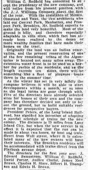
CBM tells us that he first determined to try and obtain land not too close to Shinnecock, but in the general area, within a few weeks of the time that the land was obtained by the Brooklyn Company, which was the fall of 1905. CBM offered to purchase 120 acres near the canal, and the offer was refused. The Brooklyn company was SHPBRC and they seemed to have other plans, because they immediately began developing the most accessible portions of their land, building roads and infrastructure soon thereafter. But SHPBRC was apparently not immediately developing the entire parcel. The map shows their development is on the Southern and Western portions which were more accessible, and not Sebonack Neck. CBM tells us there were 450 acres on Sebonack Neck, and that he rode it, found he could use it, and they agreed to sell him some of it! He went over it again and chose his land.
Rather than rewriting the entire narrative, why don't you just step back and tell us where those Oct. 1906 articles best fit in this narrative? They sure as hell don't fit with the 120 acres by the Canal. The timing, size, and locations are wrong. As is the result. The fit quite nicely into the 450 acres that CBM secured a few months later.
Yet you try to completely rewrite the entire narrative. All because you haven't yet thought of a way to spin this earlier date to fit with your undying agenda? So you keep trying to pretend that the land described in those articles was not the Sebonack Neck land. This is preposterous. The description fits, and by the fall of 1906, SHPBRC had been preparing their development on the land you claim he wanted for about a year! You just ignore these realities because you want to keep alive your fantasy that CBM didn't stumble onto this land until the winter of 1906? Absurd!
December 28, 1905. Brooklyn Daily Eagle.

