News:

This discussion group is best enjoyed using Google Chrome, Firefox or Safari.


DMoriarty

  • Karma: +0/-0
Re: The Creation of NGLA in Chronological, Contemporaneous News Articles
« Reply #250 on: February 09, 2011, 10:17:58 AM »
Mike Cirba?   Are you there?   Will you please put these events in chronological order?  It shouldn't take but a minute. 
Golf history can be quite interesting if you just let your favorite legends go and allow the truth to take you where it will.
--Tom MacWood (1958-2012)

Mike Cirba

Re: The Creation of NGLA in Chronological, Contemporaneous News Articles
« Reply #251 on: February 09, 2011, 01:55:43 PM »
David,

I'm greatly relieved to see that you don't believe that CBM and Whigham routed NGLA in 2-3 days on horseback when it was still an unsurveyed, imposible to walk, 450 bramble-covered acreage.  Perhaps we should try to break that news to Patrick together gently.  ;)

I now see better the source of where we actually disagree and will try to explain more shortly.

In the meantime, could you answer a question for me...do you agree with Patrick that those quotes from CBM posted the day after he secured the property were inaccurately reported and attributed?  If not, what do you think CBM meant when he said the next several months would be spent with his committee deciding what holes to reproduce and the distances of the holes?
 
Similarly, how long do you really think it took him to fully route the course and when do you believe that happened?  Thanks.
« Last Edit: February 09, 2011, 02:33:00 PM by MCirba »

Mike Cirba

Re: The Creation of NGLA in Chronological, Contemporaneous News Articles
« Reply #252 on: February 09, 2011, 02:52:21 PM »
David,

In your timeline above, I believe B & D are synonymous, so here's how I think it should look.

 A. "Jim Whigham and myself spent two or three days riding over [the 450 acres of land], studying the contours of the ground.  

B. "The company agreed to sell us 205 acres and we were permitted to locate it as best to serve our purpose." and D. "We obtained an Option on the Land in November 1906."

C.  "Again we studied the contours earnestly; selecting those that would fit in naturally with the various classical holes I had in mind, after which we staked out the land we wanted."

E.  "[We] took title to the property in the spring of 1907."

Let's look at those three pages again;


Here's why I think you are mistaken in your interpretation..

As mentioned, I think the second paragraph on page 187 (the second copied page) above summarizes the entire search for property in a nutshell.   They find the 450 acre property with a mile on Peconic Bay, they trek over it with ponies studying the ground, the company agrees to sell them 205 acres (which I think is securing the property) and permitted them to locate it wherever it suited their purposes, they subsequently study it "again" for some indeterminate amount of time after which they staked out the land they wanted.

The next paragraph describes the land they decided on.   No longer is it 450 acres with a mile of frontage on Peconic Bay;, instead, it's more specifically the strip that runs along BullsHead Bay for a mile with now only a quarter mile on Peconic, and also describes the remoteness of the site, yet still accessible.   It describes the natural sites for the four ideal template holes they found.

As mentioned yesterday, I think that part may have been a bit pre-determined once it was decided to use the Shinnecock Inn, two miles from Peconic Bay, as the clubhouse in lieu of the expense of building their own.   We can reasonably assume they wanted to get the course down near Peconic Bay with its dramatic setting, so it seems likely the selection of a somewhat narrow strip of land and an out and back routing was made in part due to some limiting factors besides selecting just the very best landforms for golf out of the 450 acres at their disposal.  (which included the site of today's Sebonack with its 3/4 mile frontage along Peconic Bay.)

The next paragraph starts to tell us the timelines around construction efforts.    It tells us the date the property was secured and that several months later it was purchased outright.   It tells us construction started immediately after purchase, describes the need to top-dress the land, and the need to place the first hole near the Shinnecock Inn which would be used as a sort of clubhouse.

Incidentally, as accurate as CBM's book is, he seems to have much confusion around the year 1909.

As mentioned previously, he confused the date of his informal soft Opening Invitational Tournament, claiming it happened in 1909, when in fact it took place on July 2,3,4 of 1910.   In that same paragraph he talks about the first tentative play happening in 1909 as well, so I'm pretty sure that's also inaccurate.

Here he mentions that the Shinnecock Inn burned to the ground in 1909, but it actually happened in early April 1908.

So, if you can tell me the timeframe you think the course was actually routed and how long this actually took perhaps we'll find we aren't so far apart in our understandings after all.

« Last Edit: February 09, 2011, 04:03:58 PM by MCirba »

DMoriarty

  • Karma: +0/-0
Re: The Creation of NGLA in Chronological, Contemporaneous News Articles
« Reply #253 on: February 09, 2011, 02:52:57 PM »
Mike, I'd appreciate an answer to my questions before I get around to answering yours.   Thanks. 
Golf history can be quite interesting if you just let your favorite legends go and allow the truth to take you where it will.
--Tom MacWood (1958-2012)

Mike Cirba

Re: The Creation of NGLA in Chronological, Contemporaneous News Articles
« Reply #254 on: February 09, 2011, 03:00:20 PM »
David,

I think our posts crossed in the mail.   

You have my response and I'd love to see yours.   Thanks.

Mike Cirba

Re: The Creation of NGLA in Chronological, Contemporaneous News Articles
« Reply #255 on: February 09, 2011, 03:39:26 PM »
David,

By the way, if you re-read the second and third pages I just posted, you do see he's reiterating and repeating himself a bit, as he did about "agreed to sell us 205 acres" and then two paragraphs later mentioning the actual month they secured the property.

For instance, twice he tells us about finding the Alps and the Redan, etc...

He's simply leading into separate points of discussion and trying to recall as comprehensively as possible, which I think makes it a wonderful document.
« Last Edit: February 09, 2011, 04:54:41 PM by MCirba »

Patrick_Mucci

Re: The Creation of NGLA in Chronological, Contemporaneous News Articles
« Reply #256 on: February 09, 2011, 09:14:27 PM »
Mike,

Here's where you go wrong.

You stated:

As mentioned, I think the second paragraph on page 187 (the second copied page) above summarizes the entire search for property in a nutshell.   They find the 450 acre property with a mile on Peconic Bay, they trek over it with ponies studying the ground, the company agrees to sell them 205 acres (which I think is securing the property) and permitted them to locate it wherever it suited their purposes, they subsequently study it "again" for some indeterminate amount of time (missing critical info)[/b] after which they staked out the land they wanted.


The CRITICAL passage you deliberately and disengenuously omitted states the following:

"Again, we studied the contours earnestly;
SELECTING THOSE THAT WOULD FIT IN NATURALLY WITH THE VARIOUS CLASSICAL HOLES I HAD IN MIND,after which we staked out the land we wanted."

Here Macdonald tells you that they found the location for each of the classic holes he had in mind (his ideal holes).

Macdonald tells you that they sited the holes on the appropriate contours PRIOR to staking out the land.
In other words, he positioned all of the holes he wanted, including his ideal holes, based on his assessment of the land after restudying it, which also provided him with the routing of the course, leading him to stake out the holes/routing he wanted for purchase.

He certainly wouldn't buy land where holes WEREN'T going to go, especially with a limited or finite purchase in mind, based upon his estimate of acquisition costs.

He wouldn't buy land where holes would be cut in half or partially designed/built.

No, he states, after restudy, he found the contours to site his ideal holes, and only after he found and located them did he stake the land for purchase.

These are his words, and no amount of omission or twisting can change them.
They're on page 187 for all to see, in their entirety, without disengenuous editing from you.

Now, as to the newspaper articles about being able to see the Atlantic Ocean from everywhere on the property except the low lying areas, while you, Bryan and others tried to convince yourselves and others that you could see the Atlantic from a single location, the hill fronting the 3rd green ( you can't)  you should know that in one sense the articles are 100 % correct.  From the location they're referencing, you can see the Atlantic Ocean, you can see Shinnecock Bay, you can see Peconic Bay.  But, not from the current site at NGLA.  You can, however, see all of those features from the 120 acre site Macdonald tried to purchase near the Shinnecock Canal.

The newspaper articles were merely copies of one another, blame the AP if you like, but, they got the properties confused.

They were blending the attributes of both properties.   The 120 acre property CBM tried to buy near the Shinnecock Canal and the 450 acre property he viewed, of which 205 acres became NGLA.

You can't see the Atlantic Ocean from EVERYWHERE except the low lying stretches at NGLA, but you can see it from EVERYWHERE except the low lying stretches on the 120 acre property he attempted to buy by the Shinnecock Canal.  Ditto for Shinnecock Bay and Peconic Bay.

The newspaper articles are nothing more than a compilation of random information presented by an author/writer who had no first hand knowledge about, not only the location of the project, but, the details of the project as well.

It would be like you getting an outdated brochure from Donald Trump regarding the original (National Fairways) course at Bedminster and confusing the information with the information about the new course at Bedminster, when you've seen neither, in their planned, construction or finished states.

Hence, newspaper articles, wherein the author/writer pieced together tidbits, without exercising due diligence, no third party verification, carry little or no weight with me, especially when we have the written words of the developer to go by.

Like these articles and the three blind men examining the elephant, you and they, got it wrong.


Jim Nugent

Re: The Creation of NGLA in Chronological, Contemporaneous News Articles
« Reply #257 on: February 10, 2011, 01:17:32 AM »
Patrick, the key word in the passage you just copied is the first:  AGAIN. 

Again they studied the land.  After those first 2 or 3 days they spent riding the 450 acres.  After they got in touch with the owners, who agreed to sell them the land they needed.

CBM tells us he found those templates, not on the first trip.  He found them later on.  Otherwise, what does "again" mean?


Mike Cirba

Re: The Creation of NGLA in Chronological, Contemporaneous News Articles
« Reply #258 on: February 10, 2011, 05:58:49 AM »
Patrick,

Jim is absolutely right.

They studied the contours of the land "again", AFTER the company agreed to sell them 205 undetermined acres of the 450 available, and AFTER the horse ride and AFTER contracts were signed to that effect on Friday, November 14, 1906.

As CBM was quoted, they THEN spent the next several months determining the holes to build and their yardages and routing the course before final purchase of the specific land they needed in the spring of 1907.  Then, construction commenced.

Let me ask you and David a related question:  do you think it is more likely that they would route the course before hiring Raynor to clear and survey the land or after? 

Mike Cirba

Re: The Creation of NGLA in Chronological, Contemporaneous News Articles
« Reply #259 on: February 10, 2011, 06:05:56 AM »
Correction...the contract signing that secured 205 unspecified acres of the 450 available took place Friday, December, not November 14th, although CBM in his book mentions they agreed in November, so that may have been when the deal was informally struck.

Mike Cirba

Re: The Creation of NGLA in Chronological, Contemporaneous News Articles
« Reply #260 on: February 10, 2011, 06:25:54 AM »
And guys...before you accuse me again of being "intellectually dishonest" here, I'm going to tell you right upfront that the Sebonac Neck property was not even a gleem in CBM's eye in early November 1906, so perhaps you'll understand the timing better.
« Last Edit: February 10, 2011, 06:40:42 AM by MCirba »

Mike Cirba

Re: The Creation of NGLA in Chronological, Contemporaneous News Articles
« Reply #261 on: February 10, 2011, 11:19:43 AM »
If you look at the bottom of the first page of "Scotland's Gift" I posted above, which is continued onto the second page, CBM tells us that he didn't want to locate his golf course too close to Shinnecock, and first made an offer for 120 acres near the canal connecting Shinnecock Bay and Peconic Bay.   That offer was ultimately rejected.   He subsequently moved on to considering the 450 acres on Sebonack Neck.

The following snippet from the New York Sun from November 1st, 1906, shows that the "Canal" land was still being negotiated for at that late date.   When one considers that Macdonald tells us he "secured" the property he eventuallly built on later in November, and signed the papers  to formalize that securing on December 14th, 1906, we see the securiing of the NGLA property was a very quick process, probably at least partly due to the rapidly rising real estate prices on the end of Long Island at that time.


Below see the area on a modern aerial.   The site of the current NGLA course and the Shinnecock course can be seen on the upper right while the "canal" and the area of "Good Ground" can be seen well west of there, as CBM described.  

« Last Edit: February 10, 2011, 11:29:51 AM by MCirba »

Patrick_Mucci

Re: The Creation of NGLA in Chronological, Contemporaneous News Articles
« Reply #262 on: February 10, 2011, 12:42:08 PM »
Patrick, the key word in the passage you just copied is the first:  AGAIN. 

Again they studied the land.  After those first 2 or 3 days they spent riding the 450 acres.  After they got in touch with the owners, who agreed to sell them the land they needed.

CBM tells us he found those templates, not on the first trip.  He found them later on.  Otherwise, what does "again" mean?

It means ..... again, that they went back and fine tuned their previous finds

What you forget and what Mike Cirba doesn't want to remember, is the previous passages and the passage that follows.

I'll cite them for you, capitalizing the critical parts.

"So Jim Whigham and myself spent two or three days riding over it. STUDYING THE CONTOURS OF THE GROUND.
FINALLY, WE DETERMINED IT WAS WHAT WE WANTED, providing we could get it reasonably. IT ADJOINED THE SHINNECOCK HILLS GOLF COURSE.  The company agreed to sell us 205 acres, and WE WERE PERMITTED TO LOCATE IT AS BEST TO SERVE OUR PURPOSE.
Again, we studied the land earnestly; selecting those that would fit in naturally with the various classical holes I had in mind, after which we staked out the land we wanted."

CBM tells us where the 205 acres was BEFORE he returned for the fine tuning process, it was the land that ADJOINED SHINNECOCK HILLS.

It wasn't on the Sebonack site, it was the current site.

He knew, before returning for fine tuning, what land he needed.  It was the land adjoining Shinnecock Hills.

They then returned to complete the fine tuning process, completed that process and then and only then did they stake the defined boundaries, and subsequently bought that land. 


Bryan Izatt

  • Karma: +0/-0
Re: The Creation of NGLA in Chronological, Contemporaneous News Articles
« Reply #263 on: February 10, 2011, 12:49:08 PM »
Bryan,

Earlier you said that there looked to be about 40 acres of land East of the 15th and 16th.  That sounds way too high to me.  I've measured it a few times and it looks like the land between the water and the holes (which is pretty rough land) is less than 20 acres.  I get less than 15 acres for the triangle of land were the range is located, north of the 17th green and the first half of the 18th fairway.    Are you combining these two parcels in your measure?  And maybe throwing in some of the land protruding out into the bay beyond the road?  

________________________________________

...........................


David, my bad.  I was going with a faulty memory on the 40 acres.  The area east of 16 and 17 is about 17 acres.  The area north of 17 and 18 is about 12 acres.  Now, if you add in the the island, you could get the total up to about 56 acres  :)  The deed for the property would be interesting to see.  I'm wondering who owned the right of way to the island.

If you were presented with an opportunity today to buy 205 acres out of the 450 acre property, what would you pick?  That mile of shoreline along Peconic Bay looks might attractive.  Not sure why CBM would have passed it up other than the landforms he was looking for were not there.

In any event, given how tightly the course seems to fit in the 205 acres, it's hard to imagine how they would have thought they could have fit it in there and still had usable acreage left over for acre sized cottage lots.


Patrick_Mucci

Re: The Creation of NGLA in Chronological, Contemporaneous News Articles
« Reply #264 on: February 10, 2011, 02:02:20 PM »

David, my bad.  I was going with a faulty memory on the 40 acres.  The area east of 16 and 17 is about 17 acres.  The area north of 17 and 18 is about 12 acres.  

Now, if you add in the the island, you could get the total up to about 56 acres  :)  The deed for the property would be interesting to see.  I'm wondering who owned the right of way to the island.

The property east of Sebonic Inlet Road including Ram Island is private property.
Someone familiar with digging up public records could probably trace its history.
I'm 99.9 % sure that it was never incorporated in the original 205 acres CBM purchased.


If you were presented with an opportunity today to buy 205 acres out of the 450 acre property, what would you pick?  

Wouldn't that depend upon your agenda ?

How do you find the holes at Sebonack that are adjacent to Peconic Bay ?
Are they outstanding ?
And, how would you route the course to utilize the water front property ?
Also remember, that the property that's south of the bay sits up on a bluff for most of the way.


That mile of shoreline along Peconic Bay looks mighty attractive.  

Perhaps from the air, but, if you'll look at the elevation changes behind the 18th green at NGLA, it's not without its problems.
The other question I would ask is, how did the holes that directly border Peconic Bay at Sebonack turn out, and, how would you get back to the Shinnecock Inn, the temporary clubhouse while still incorporating the ideal holes, such as the Redan, Alps, Eden, Cape and Sahara ?
Had the project been 36 holes, I'm sure he would have incorporated the land adjoining Peconic Bay.

But CBM had specific holes in mind and he told us that he found them after his first two to three day ride-around in that long narrow strip of land that adjoined Shinnecock Hills Golf Course .

 
Not sure why CBM would have passed it up other than the landforms he was looking for were not there.

I don't think CBM passed up anything.
I think he took the land/sites he needed for his ideal holes.
I'd say, judging by the results, that he picked the right land/sites and got it right.
[/b]

In any event, given how tightly the course seems to fit in the 205 acres, it's hard to imagine how they would have thought they could have fit it in there and still had usable acreage left over for acre sized cottage lots.

AGREED
[/b]


Patrick_Mucci

Re: The Creation of NGLA in Chronological, Contemporaneous News Articles
« Reply #265 on: February 10, 2011, 02:11:20 PM »
Mike,

The print on the article is fuzzy, and my eyes not too good.
What's the word after "Montauk" in the newspaper article ?

It looks like "point" or "Polol".  I can't make it out.

Could you or Joe clarify it for us.

Joe Bausch

  • Karma: +0/-0
Re: The Creation of NGLA in Chronological, Contemporaneous News Articles
« Reply #266 on: February 10, 2011, 02:29:00 PM »
Mike,

The print on the article is fuzzy, and my eyes not too good.
What's the word after "Montauk" in the newspaper article ?

It looks like "point" or "Polol".  I can't make it out.

Could you or Joe clarify it for us.

Here is a better version of that note from the November 1, 1906 edition of the NY Sun.  It is from a larger golf article.

@jwbausch (for new photo albums)
The site for the Cobb's Creek project:  https://cobbscreek.org/
Nearly all Delaware Valley golf courses in photo albums: Bausch Collection

Mike Cirba

Re: The Creation of NGLA in Chronological, Contemporaneous News Articles
« Reply #267 on: February 10, 2011, 04:38:37 PM »
Bryan,

There are a couple of things at play in the selection and overall usage of total acreage.   The first is that the course that opened originally was just over 6000 yards while today's course is much longer.   But it's really in the area of fairway width that I think the course grew larger than planned.   I have an August, 1907 article here I posted previously that states the targeted fairway widths are 50-55 yards, just like CBM originally envisioned on his "Ideal Course".   That was well into the start of construction.

Today's farways are conservatively 25-35 pct. wider than that, and some are enormous.   I think what happened is CBM realized that creating "options" to navigate around his hazards and create safe avenues for the weaker players took much more real estate than he originally figured.

As far as limiting factors on which of the 450 acres he used, Patrick is being obstinate.   CBM himself tells us that they didn't have money for a clubhouse originally so needed to locate their original first tee (today's 10th) near the existing Shinnecock Inn which would serve as the clubhouse.   That was located back by today's 9th green/10th tee, about 2 miles from the shores of Peconic Bay.    Obviously that highly factored into the routing, as was the desire to use what shoreline was available.  

So, they "skirted" BullsHead Bay, which is a less impressive visual attraction and went down and used as much of the stretch along Peconic Bay as 205 acres would permit, with the need to trek back.

Geoff Walsh and I played Sebonack this past spring and he asked the very same question you did.   The land there is amazing.   But, like everyone, CBM had to play with the limitations he was given, I believe.

Patrick,

CBM was looking for landforms for a couple of "Copied" template holes...the Alps, redan, and Eden, and happened to find the Cape along the way.   He had no plan by that time to create 18 copies, but instead would create "Composite" holes and original holes based on what the land provided.

Those are the landforms they were looking for and found during the first horse ride.  If you don't believe me, ask David.

They did not identify and route 18 holes during those 2-3 days looking over 450 iimpassibe acres of bramble.

They did that later after hiring Raynor and clearing and surveying the land.

I know it's hard to stop believing in Santa CBM, but he did a great job anyway.  ;)  ;D
« Last Edit: February 10, 2011, 04:49:28 PM by MCirba »

Joe Bausch

  • Karma: +0/-0
Re: The Creation of NGLA in Chronological, Contemporaneous News Articles
« Reply #268 on: February 10, 2011, 05:10:04 PM »
More on Mountauk Point.  This from the Dec 11, 1906 edition of the NY Sun.

@jwbausch (for new photo albums)
The site for the Cobb's Creek project:  https://cobbscreek.org/
Nearly all Delaware Valley golf courses in photo albums: Bausch Collection

Mike Cirba

Re: The Creation of NGLA in Chronological, Contemporaneous News Articles
« Reply #269 on: February 10, 2011, 05:47:58 PM »
Joe,

Nice find...thanks for posting it as well as the clearer version of the other.

I wonder if anyone is going to answer my questions from yesterday?

I'm not sure why people are so reluctant to take Nacdonald at his word that he was going to spend the next several months working with his committee determining what holes to reproduce as well as their yardages on the then unspecified 450 acres?  Especially since we now know indisputably that these direct quotes weren't taken from some marketing literature published months or years earlier as Pat suggested but instead now know they were direct quotes published contemporaneously up to the time of securing the land in Dec 1906.

I'm not sure why its easier to believe that CBM routed 18 holes on impassible 450 acres in two days than accept the reality that they needed to first hire Raynor, then clear and survey the land, and then locate their holes and construct their golf course?

It is now very clear that's exactly what happened, just as CBM told us.

DMoriarty

  • Karma: +0/-0
Re: The Creation of NGLA in Chronological, Contemporaneous News Articles
« Reply #270 on: February 10, 2011, 05:51:52 PM »
David, my bad.  I was going with a faulty memory on the 40 acres.  The area east of 16 and 17 is about 17 acres.  The area north of 17 and 18 is about 12 acres.  Now, if you add in the the island, you could get the total up to about 56 acres  :)  The deed for the property would be interesting to see.  I'm wondering who owned the right of way to the island.

Thanks Bryan.  That is more inline with what I had come up with.   

Quote
If you were presented with an opportunity today to buy 205 acres out of the 450 acre property, what would you pick?  That mile of shoreline along Peconic Bay looks might attractive.  Not sure why CBM would have passed it up other than the landforms he was looking for were not there.

I agree.  CBM selected a strangely shaped, tight fitting property out of a much larger parcel.   This in and of itself provides a very good indication that the selection of this property was a product of where he found his golf course.   Why would he have drawn these particular lines and then try to jam a golf course in there?   He was given had the opportunity to borders to the specific needs of the course, and I have trouble understanding why he wouldn't have done exactly that. 

That his what I don't get about Mike's ever evolving understanding of what happened here.   Long ago, when he first started with this pointed enquiry aimed at making some petty point regarding Merion, his claim was that CBM bought this particular land having little idea of where the holes would go.  Then after locking himself into this land, he got around to coming up with a routing for the golf course.  That claim was and is preposterous.

Now he has finally backed well off such a claim.  Or has he?   He still seems to be speaking out of both sides of his mouth on the issue.   He is playing lip service to this notion that CBM had somehow locked himself in to the land without bothering to come up with a routing, and without even bothering to check whether he could fit both a golf course and 90 acres of development on the property!  Yet he also seems to be claiming that well into 1907, CBM hadn't locked himself into anything, and could have scrapped this land altogether built Sebonack instead of NGLA!   
________________________________________________

Mike Cirba.

You seem to have tied yourself in knots here.     

You claimed that CBM's description was chronological.  Yet when the chronological reading doesn't suit you, you ditch that and claim he was hopping around as if on hot coals.   I don't get it.   

I think the chronology as it appears in the book (and as I have listed above) sets it out rather clearly, and makes much more sense than yours.   I still don't even understand your chain of events, and I don't think you do either

For example, here is what you wrote to Patrick just this morning:

"Jim is absolutely right.

They studied the contours of the land "again", AFTER the company agreed to sell them 205 undetermined acres of the 450 available, and AFTER the horse ride and AFTER contracts were signed to that effect on Friday, November 14, 1906."


But then you tell us that that the correct date was Friday, December 14, 1906?   Well then if "Jim is absolutely right" then the night of December 14, 1906 was one hell of a night!    Because by the morning of December 15, 1906, the papers not only announced the deal, they also accurately described the property, including the mile of frontage on Bulls Head Bay, the location of the starting hole (and by implication of the location of the finishing hole and much more.) and the Alps hole, the Redan, the Eden, and the Cape!   How is this possible that they had done all this yet hadn't bothered to yet consider what land they actually wanted or how the holes would fit in? 

Here again is C. from the above chronology I derived directly from the book:

"Again we studied the contours earnestly; selecting those that would fit in naturally with the various classical holes I had in mind, after which we staked out the land we wanted."

You have that happening AFTER the land was optioned, which would mean that as of mid-December, they hadn't really done anything except spend ride over the land, and they had NOT YET DETERMINED THE LAND THEY WANTED.   

There is plenty more that doesn't make sense, but lets stop for now.
________________________________________________________

Joe,

I believe mentioned tournament was the Lesley Cup matches which had taken place the week before.   The same day, this article appeared in the Brooklyn Daily Eagle.   


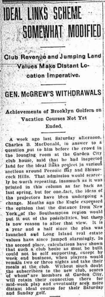
Note that, according to the article, CBM claimed to have been looking "in various sections around Peconic Bay and Shinnecock Hills."   So Mike's assertion that this property wasn't even a "gleem in CBM's eye" is hyperbolic at best. 

Here is an article from the  Boston Journal, October 16th, 1906, announcing that CBM had purchased 250 acres, and what seems to be a derivative article from the Globe on the same day.


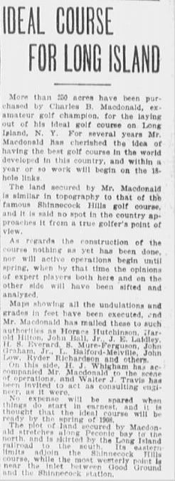
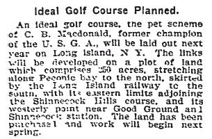
Now both these articles obviously have some details incorrect or at least confused, but they are worth seriously considering if only because CBM, HJW, and Walter Travis were all in Boston at the time for a big invitational tournament at Myopia, and therefor may have been the direct or indirect sources behind the articles.    There are a number of interesting details, but lets touch on just a couple, starting with the description of the land involved:
--  250 acres.  (Much more than the 120 supposedly sought by the Canal, and a bit more than was ultimately purchased at Sebonack.)
-- Stretches along Peconic Bay to the north.
-- Is skirted by the RR to the south.   (This could either mean bordered by the RR or missed the RR by a narrow margin.) 
-- Adjoins Shinnecock Hills course to the East,
-- Westernly point was somewhere "near the inlet between Good Ground and Shinnecock Hills Station."  

This last bit is odd, because Good Ground is a long ways west of Shinnecock Hills golf course, and even across the canal, while the old Shinnecock Hills RR Station was not far at all.  The question is, to what inlet does the article refer?   "Inlet" could mean the canal itself, but as I said, that would create a rather large area for a 250 acre golf course, and why would they have called it an inlet instead of a canal?   "Inlet" could also refer to Cold Spring Harbor, the inlet for which is between the RR station and Good Ground.

Anyway,  the purposes of figuring out what land was involved, I am not sure it makes any difference.  So far as I can tell, and so far as CBM describes, both potential sites were part of one big 2000 acre chunk of land controlled by the same interest, the Shinnecock Hills and Peconic Bay Real Estate Company.  That said, latter interpretation of "inlet" makes much more sense in that context of what happened, in that it matches CBM's description of getting agreement from the seller to let CBM place his course on the 450 acres between Bulls Head Bay and Cold Spring Harbor.

What is as interesting to me is that at this point, mid-October 1906,  CBM, HJW, Travis or whoever seems to think that CBM has some sort of deal which would allow him to build a golf course adjacent to the  Shinnecock Hills course.  

Also note that at this point HJW had reportedly accompanied CBM to the site.

__________________________________________

Mike, I have been avoiding the issue because there is too much else ongoing, but you are cracked on this issue of fairway widths. 

First, CBM's fairway widths described for his "ideal course" went up to 60 yards, not 55. 
Second, your representation that the fairways are "conservatively 25-35% wider" than that is downright dishonest.  If they were 35% wider than 60 yards they'd all be 81 yards wide.  I have no idea how you could claim these fairways were over 70 yards on average, but I suggest you take another look.   Obviously, with fairways with bends and changes of angles, you cannot fudge to find the furthest measure, because obviously that is not what CBM was talking about.  No doubt you did though.
Third, your methodology is as suspect as your claim.   CBM wasn't concerned with minimizing land use, he was concerned with the width of driving corridors, so that some little bit of accuracy was required.  And if one examines driving corridors, (or layup corridors on longer holes) the course fits well within the 45 - 60 yard prescription.  So you must have come up with your numbers by ignoring this reality. 
-- For example, a number of holes (bottle, hogback, leven, etc.) have what amount to split driving areas defined by bunkers, but no doubt you ignored that these were discrete landing areas and measured it sll as if it was one big fairway.
-- For another example, other fairways, had natural features which obviously required wide corridors even to make them playable (like the large basin on the right side of the second hole, the depressions on the punchbowl hole and on the alps hole.)  Again you likely ignored this and just measured them as if they were on flat ground.
In short, this is just another failure on your part to accurately convey information or to accurately understand what CBM was getting at.  He wasn't setting down some hard and fast rule by which all courses must abide no matter what the conditions.  Rather he was giving guidelines which had to be applied with intelligence to the circumstance at hand.   This is what you seem to be missing throughout. 
Golf history can be quite interesting if you just let your favorite legends go and allow the truth to take you where it will.
--Tom MacWood (1958-2012)

Mike Cirba

Re: The Creation of NGLA in Chronological, Contemporaneous News Articles
« Reply #271 on: February 10, 2011, 05:57:48 PM »
David,

Do you plan to answer my simple questions from yesterday?

Mike Cirba

Re: The Creation of NGLA in Chronological, Contemporaneous News Articles
« Reply #272 on: February 10, 2011, 06:23:20 PM »
David,

By the way, part of your misunderstanding is that the "Good Ground" property was owned by Shinnecock Hills and Peconic Bay Realty Co. And the land they actually purchased was from 450 acres controlled by the Dean Alvord Syndicate.

And yes, he evidently was hopping around the over 2000 acres of the former for some time before they rejected his offer sometime in November 1906, and he moved very quickly on the Alford property once he saw it had features he could use, including the Shinnecock Inn for a clubhouse 2 miles from Peconic Bay as he noted.

I think at that point CBM was concerned about possibly getting squeezed out of a market with rapidly escalating real estate prices, as noted, and once he was comfortable that he could secure good landforms and soil for his golf course, he moved aggressively.

Also, CBM  himself said he made an offer for 120 acres, not 250.   Do you think he was mistaken?
« Last Edit: February 10, 2011, 07:23:08 PM by MCirba »

Mike Cirba

Re: The Creation of NGLA in Chronological, Contemporaneous News Articles
« Reply #273 on: February 10, 2011, 07:37:41 PM »
David,

Those articles you posted are really interesting, and it should be possible to determine from the boundaries the exact land that CBM really wanted first for his Ideal Golf Course.

But, yes, that's land not owned by the Alvord Syndicate and is instead closer to "Good Ground" and stretches out to the Shinnecock Canal to the west...he evidently found the Sebonac Neck land he used after his original offer for the GG land was rejected as discussed in his book. 

Interesting to note that he was so far down the road to purchase of the first that he'd already had surveyor maps sent to some of his confidants.   I wonder if he hired the surveyor?   Most likey the land had been previously surveyed.

As he told us, the land he eventually settled on owned by Alvord was 450 unsurveyed acres, thus begat Seth Raynor.

Patrick_Mucci

Re: The Creation of NGLA in Chronological, Contemporaneous News Articles
« Reply #274 on: February 10, 2011, 07:46:06 PM »

As far as limiting factors on which of the 450 acres he used, Patrick is being obstinate.   CBM himself tells us that they didn't have money for a clubhouse originally so needed to locate their original first tee (today's 10th) near the existing Shinnecock Inn which would serve as the clubhouse.

Mike, you might want to reread what Macdonald stated.  They didn't have the money, INITIALLY, for the clubhouse, hence, they would use the SI as their temporary.  But, when one examines the huge gap, in allegedly, by you and others, the best land on the site, overlooking Peconic Bay, it could be for one purpose and one purpose only, the eventual permanent clubhouse.
[/b]

That was located back by today's 9th green/10th tee, about 2 miles from the shores of Peconic Bay.    Obviously that highly factored into the routing, as was the desire to use what shoreline was available.  

Then why did he ONLY USE SO LITTLE of the shoreline (1/2 the 18th hole) ?
There's a simple answer, because he wasn't focused on the views, he was focused on finding the best location for his 18 ideal holes.
[/b]

So, they "skirted" BullsHead Bay, which is a less impressive visual attraction and went down and used as much of the stretch along Peconic Bay as 205 acres would permit, with the need to trek back.

Again, you're being dishonest.
The visual attraction had nothing to do with it.
In the land paralleling Bullshead Bay he found his Eden, Cape, Punchbowl and Leven holes.
That's what he was searching for, sites for his ideal holes, and he found them in that location.
At least, that's what HE tells us.
[/b]

Geoff Walsh and I played Sebonack this past spring and he asked the very same question you did.   The land there is amazing.   But, like everyone, CBM had to play with the limitations he was given, I believe.

Again, another deceitful statement.
He didn't have any limitations.  he could take any configuration of the 450 acres that best suited HIS NEEDS and HIS NEEDS were the siting of the "Ideal Holes" he had identified
[/b]

Patrick,

CBM was looking for landforms for a couple of "Copied" template holes...the Alps, redan, and Eden, and happened to find the Cape along the way.   He had no plan by that time to create 18 copies, but instead would create "Composite" holes and original holes based on what the land provided.


Again, that's a total lie.
If you'd read the bottom of page 183 and page 184 he tells you that he had 18 ideal holes in mind and that he would site them if the ground was in harmony with each hole.
And, he describes some of them as being composites.
For you to decree that CBM only had a few holes he wanted to site is a blatant lie, contrary to what he clearly stated.
He stated he wanted an Alps, a leven, an Eden, a Redan, a Sahara, a Road, a Bottle  and others, 18 in all.
So please stop misrepresenting his efforts as being limited to 3 then 4 holes, with the rest to be figured out at some point in the future.
[/b]

Those are the landforms they were looking for and found during the first horse ride.  If you don't believe me, ask David.

He was looking for an Alps, an Eden and a Redan, but, he was also looking for:  A ROAD, A LEVEN, A BOTTLE, A SAHARA, A CAPE, A PUNCHBOWL and other composite holes that he describes in detail on page 184, along with some originals of his own crafting, based on the land and his concept of ideal holes.
[/b]

They did not identify and route 18 holes during those 2-3 days looking over 450 iimpassibe acres of bramble.

First of all, it wasn't 450 acres of impassible brambles.
Much of it was swamp and bogs, unfit for golf, so that was discarded quickly, unless you'd have us believe that they rode around and studied the bogs and swamps.
I think they did route the golf course in global or macro terms, which was made easy by the discovery of land forms that perfectly fit some of his ideal holes, like the Alps, Redan, Cape, Eden and others.
They found sites to locate some of their ideal holes making the location of the others all the easier.
They knew it was the land that adjoined Shinnecock Hills Golf Course.
Macdonald STATES THAT, prior to his second visit to "fine tune" their original find.
The land he wanted adjoined Shinnecock Hills, not Peconic Bay or Cold Spring Pond
[/b]

They did that later after hiring Raynor and clearing and surveying the land.

That's another lie.
Would you cite where CBM makes that statement ?
Failing to provide that citation would you admit that you made this up to advance your agenda.
[/b]

I know it's hard to stop believing in Santa CBM, but he did a great job anyway.  ;)  ;D

If anyone believes in fairy tales, it's you.
You reject CBM's own words, prefering to rely on erroneous newspaper accounts that can't even get NGLA's location right.

I have NO agenda, YOU DO !
[/b]

Tags:
Tags:

An Error Has Occurred!

Call to undefined function theme_linktree()
Back