David, my bad. I was going with a faulty memory on the 40 acres. The area east of 16 and 17 is about 17 acres. The area north of 17 and 18 is about 12 acres. Now, if you add in the the island, you could get the total up to about 56 acres  The deed for the property would be interesting to see. I'm wondering who owned the right of way to the island.
Thanks Bryan. That is more inline with what I had come up with.
If you were presented with an opportunity today to buy 205 acres out of the 450 acre property, what would you pick? That mile of shoreline along Peconic Bay looks might attractive. Not sure why CBM would have passed it up other than the landforms he was looking for were not there.
I agree. CBM selected a strangely shaped, tight fitting property out of a much larger parcel. This in and of itself provides a very good indication that the selection of this property was a product of where he found his golf course. Why would he have drawn these particular lines and then try to jam a golf course in there? He was given had the opportunity to borders to the specific needs of the course, and I have trouble understanding why he wouldn't have done exactly that.
That his what I don't get about Mike's ever evolving understanding of what happened here. Long ago, when he first started with this pointed enquiry aimed at making some petty point regarding Merion, his claim was that
CBM bought this particular land having little idea of where the holes would go. Then after locking himself into this land, he got around to coming up with a routing for the golf course. That claim was and is preposterous.
Now he has finally backed well off such a claim. Or has he? He still seems to be speaking out of both sides of his mouth on the issue. He is playing lip service to this notion that CBM had somehow locked himself in to the land without bothering to come up with a routing, and without even bothering to check whether he could fit both a golf course and 90 acres of development on the property! Yet he also seems to be claiming that well into 1907, CBM hadn't locked himself into anything, and could have scrapped this land altogether built Sebonack instead of NGLA!
________________________________________________
Mike Cirba.
You seem to have tied yourself in knots here.
You claimed that CBM's description was chronological. Yet when the chronological reading doesn't suit you, you ditch that and claim he was hopping around as if on hot coals. I don't get it.
I think the chronology as it appears in the book (and as I have listed above) sets it out rather clearly, and makes much more sense than yours. I still don't even understand your chain of events, and
I don't think you do either.
For example, here is what you wrote to Patrick just this morning:
"Jim is absolutely right.
They studied the contours of the land "again", AFTER the company agreed to sell them 205 undetermined acres of the 450 available, and AFTER the horse ride and AFTER contracts were signed to that effect on Friday, November 14, 1906."But then you tell us that that the correct date was Friday,
December 14, 1906? Well then if "Jim is absolutely right" then the night of
December 14, 1906 was one hell of a night! Because by the morning of December 15, 1906, the papers not only announced the deal, they also accurately described the property, including the mile of frontage on Bulls Head Bay, the location of the starting hole (and by implication of the location of the finishing hole and much more.) and the Alps hole, the Redan, the Eden, and the Cape! How is this possible that they had done all this yet hadn't bothered to yet consider what land they actually wanted or how the holes would fit in?
Here again is C. from the above chronology I derived directly from the book:
"Again we studied the contours earnestly; selecting those that would fit in naturally with the various classical holes I had in mind, after which we staked out the land we wanted." You have that happening AFTER the land was optioned, which would mean that as of mid-December, they hadn't really done anything except spend ride over the land, and they had NOT YET DETERMINED THE LAND THEY WANTED.
There is plenty more that doesn't make sense, but lets stop for now.
________________________________________________________
Joe,
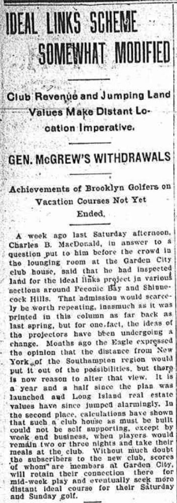
I believe mentioned tournament was the Lesley Cup matches which had taken place the week before. The same day, this article appeared in the Brooklyn Daily Eagle.

Note that, according to the article, CBM claimed to have been looking "in various sections around Peconic Bay and Shinnecock Hills." So Mike's assertion that this property wasn't even a "gleem in CBM's eye" is hyperbolic at best.
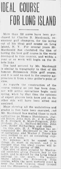
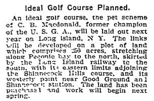
Here is an article from the Boston Journal, October 16th, 1906, announcing that CBM had purchased 250 acres, and what seems to be a derivative article from the Globe on the same day.


Now both these articles obviously have some details incorrect or at least confused, but they are worth seriously considering if only because CBM, HJW, and Walter Travis were all in Boston at the time for a big invitational tournament at Myopia, and therefor may have been the direct or indirect sources behind the articles. There are a number of interesting details, but lets touch on just a couple, starting with the description of the land involved:
-- 250 acres. (Much more than the 120 supposedly sought by the Canal, and a bit more than was ultimately purchased at Sebonack.)
-- Stretches along Peconic Bay to the north.
-- Is skirted by the RR to the south. (This could either mean bordered by the RR or missed the RR by a narrow margin.)
--
Adjoins Shinnecock Hills course to the East,
-- Westernly point was somewhere "near the inlet between Good Ground and Shinnecock Hills Station."
This last bit is odd, because Good Ground is a long ways west of Shinnecock Hills golf course, and even across the canal, while the old Shinnecock Hills RR Station was not far at all. The question is, to what inlet does the article refer? "Inlet" could mean the canal itself, but as I said, that would create a rather large area for a 250 acre golf course, and why would they have called it an inlet instead of a canal? "Inlet" could also refer to Cold Spring Harbor, the inlet for which is between the RR station and Good Ground.
Anyway, the purposes of figuring out what land was involved, I am not sure it makes any difference. So far as I can tell, and so far as CBM describes, both potential sites were part of one big 2000 acre chunk of land controlled by the same interest, the Shinnecock Hills and Peconic Bay Real Estate Company. That said, latter interpretation of "inlet" makes much more sense in that context of what happened, in that it matches CBM's description of getting agreement from the seller to let CBM place his course on the 450 acres between Bulls Head Bay and Cold Spring Harbor.
What is as interesting to me is that at this point, mid-October 1906, CBM, HJW, Travis or whoever seems to think that CBM has some sort of deal which would allow him to build a golf course adjacent to the Shinnecock Hills course.
Also note that at this point HJW had reportedly accompanied CBM to the site.
__________________________________________
Mike, I have been avoiding the issue because there is too much else ongoing, but you are cracked on this issue of fairway widths.
First, CBM's fairway widths described for his "ideal course" went up to 60 yards, not 55.
Second, your representation that the fairways are "conservatively 25-35% wider" than that is downright dishonest. If they were 35% wider than 60 yards they'd all be 81 yards wide. I have no idea how you could claim these fairways were over 70 yards on average, but I suggest you take another look. Obviously, with fairways with bends and changes of angles, you cannot fudge to find the furthest measure, because obviously that is not what CBM was talking about. No doubt you did though.
Third, your methodology is as suspect as your claim. CBM wasn't concerned with minimizing land use, he was concerned with the width of driving corridors, so that some little bit of accuracy was required. And if one examines driving corridors, (or layup corridors on longer holes) the course fits well within the 45 - 60 yard prescription. So you must have come up with your numbers by ignoring this reality.
-- For example, a number of holes (bottle, hogback, leven, etc.) have what amount to split driving areas defined by bunkers, but no doubt you ignored that these were discrete landing areas and measured it sll as if it was one big fairway.
-- For another example, other fairways, had natural features which obviously required wide corridors even to make them playable (like the large basin on the right side of the second hole, the depressions on the punchbowl hole and on the alps hole.) Again you likely ignored this and just measured them as if they were on flat ground.
In short, this is just another failure on your part to accurately convey information or to accurately understand what CBM was getting at. He wasn't setting down some hard and fast rule by which all courses must abide no matter what the conditions. Rather he was giving guidelines which had to be applied with intelligence to the circumstance at hand. This is what you seem to be missing throughout.