News:

This discussion group is best enjoyed using Google Chrome, Firefox or Safari.


DMoriarty

  • Karma: +0/-0
Re: The Creation of NGLA in Chronological, Contemporaneous News Articles
« Reply #1100 on: March 24, 2011, 03:57:15 PM »
From the same 1908 RR promotional as pictured above:
. . . Good Ground and the fashionable Shinnecock Hills with its beautiful roads laid out by the landscape architects, Olmstead Brothers and Downing Vaux from which may be had superb views of the surrounding land and waters of the bay and ocean.
. . .
The most important of the Hamptons is Southampton, where the air of social refinement is fully equal to that of the most fashionable watering places in America.  Within its borders there is a small lake and many beautiful drives, not only to the beach but to the backcountry overlooking Peconic Bay.
Golf history can be quite interesting if you just let your favorite legends go and allow the truth to take you where it will.
--Tom MacWood (1958-2012)

Patrick_Mucci

Re: The Creation of NGLA in Chronological, Contemporaneous News Articles
« Reply #1101 on: March 24, 2011, 05:02:17 PM »

I was looking at George's book in the Old Mac clubhouse today and saw the original blueprint of the course.  At a glance, it struck me that the shape of the property looked like a mirror image of the shape of The Old Course property.  Could CBM's routing have been inspired by the routing of TOC?

Bryan,

I had mentioned that earlier.

What triggered my comment was Max Behr's article about NGLA, TOC and how NGLA routed itself.

In addition to TOC, I think CBM was influenced by the out and back routings of many of the UK Links courses.

However, I don't think 120 acres on a squarelike parcel would accomodate an out and back routing


Patrick_Mucci

Re: The Creation of NGLA in Chronological, Contemporaneous News Articles
« Reply #1102 on: March 24, 2011, 05:14:12 PM »
Guys,


Still, I'd like to make the case for it and would be happy to take constructive criticism.  

Please just don't tell me that barely travelled dirt roads running through the area in 1906 were going to be an impediment to building a golf course anywhere that CBM and Alvord agreed was desirable because that's preposterous.

Mike, they weren't "BARELY TRAVELED DIRT ROADS"  Once again, you're misrepresenting the facts.  Once again, you're being disingenuous.
They were well travled roads.  Please, look again at the advertisements for the Shinnecock Inn, located ON THE NORTH HIGHWAY.

You continually make these extreme pronouncements and then use the extreme pronouncement as the foundation for another speculative theory.

The advertisements refer to "Automobile parties, garages, a complete system of GOOD roads, yet you continually ignore the facts, prefering instead to make false statements about the conditions circa 1906-07.

How much longer are you going to maintain this charade in the face of overwhelming, independent source documentation ?


David,

Thanks for taking the time to do all that drawing.

I do think it's important to note that the North Highway was never drawn as on the Olmstead Plan, especially that part near Shinny and NGLA.?

As drawn on his Land Plan, he had the highway going along the north boundary of Shinnecock Hills, and when the actual highway was built, it went south of Shinnecock Hills, down along the tracks.

Mike, the North Highway EXISTED PRIOR TO THE OLMSTED MAP/'PLAN.
The North Highway didn't come into existance after the Olmsted map/plan.
While roads may have been realigned, the fact is that the North Highway existed prior to the Olmsted Plan.
It's shown on map after map after map predating the Olmsted plan


Patrick_Mucci

Re: The Creation of NGLA in Chronological, Contemporaneous News Articles
« Reply #1103 on: March 24, 2011, 05:20:38 PM »


I think your measurements are INACCURATE.

The entire width of the isthmus east of the canal from the water jutting down in the lower right from the North Highway to the Atlantic Ocean is only 1,320 yards.
I'd feel more comfortable if Bryan or David calculated the measurements as you've been prone to error.


Here is a modern aerial.   I've drawn three lines.  

The first on the left shows what would have been the narrowest point of what I proposed, from the edge of Peconic Bay to an actual road that looks close to traversing the same route as whatever that old dirt road was on those 1905 maps.   It is 200 yards.

It's less than that, especially when you've angled it.
That road WAS the NORTH HIGHWAY.
I believe it's called the "Old North Highway" today.


The next shows the distance from the northern boundary I proposed to the actual North Highway that was eventually built MANY years later.   It's 400 yards, actually 405 yards to be precise.

That's the "SUNRISE HIGHWAY"


The last line, which actually more reflects the reality of the time, shows that it was over 750 yards from that boundary to the rail line, where there is PLENTY of room to re-route a dirt road if necessary.  

Why didn't you show more of the aerial to the EAST.
Where the North Highway is RIGHT ON THE WATER, RIGHT ON COLD SPRING POND, RIGHT IN THE MIDDLE OF WHERE YOUR PHANTOM GOLF COURSE WAS SUPPOSED TO BE.

Don't just present a partial portion of your phantom course, present the entire area, not what's convenient to your agenda.

« Last Edit: March 24, 2011, 05:47:48 PM by Patrick_Mucci »

Patrick_Mucci

Re: The Creation of NGLA in Chronological, Contemporaneous News Articles
« Reply #1104 on: March 24, 2011, 05:25:47 PM »
Mike,

Look at the driveways to these "summer cottages".

Why would someone build such elaborate driveways if there were only dirt roads that barely got any traffic on them, as you contend.


The overwhelming documented evidence destroys your misrepesentations, misrepresentations that only "stupid" stubborn people would cling to.

Patrick_Mucci

Re: The Creation of NGLA in Chronological, Contemporaneous News Articles
« Reply #1105 on: March 24, 2011, 05:38:35 PM »
Mike,

In the 1906-07 ad for Shinnecock Hills, it distinctly states.

"It's attraction and advantages are:

A complete system of good roads for riding, driving or motoring"
[/b][/size]

The ad/s go on to state:


Take the NEW North Highway at the Shinnecock Canal to the NEW Shinnecock Inn.
Especially arranged for AUTOMOBILE PARTIES, with GARAGE and every convenience.


For you to continue to deny the existance of the North Highway, traffic and automobile use is being blatantly disingenuous.
There's just no other way to describe your insistance that only a few dirt roads existed and that they were barely traveled, which is what you've maintained.

JESII

  • Karma: +0/-0
Re: The Creation of NGLA in Chronological, Contemporaneous News Articles
« Reply #1106 on: March 24, 2011, 07:58:11 PM »
WHO CARES ABOUT THE QUALITY OF THE ROADS...THE SITE IN QUESTION WAS NEITHER THE CANAL SITE OR THE SEBONAK NECK SITE.

DMoriarty

  • Karma: +0/-0
Re: The Creation of NGLA in Chronological, Contemporaneous News Articles
« Reply #1107 on: March 24, 2011, 09:03:44 PM »
WHO CARES ABOUT THE QUALITY OF THE ROADS...THE SITE IN QUESTION WAS NEITHER THE CANAL SITE OR THE SEBONAK NECK SITE.

I agree with the first part and agree that "the site in question" was not the Canal site.   But "the site in question" was the Sebonack Neck site, was it not?  The Sebonack Neck site was the one on which the course was ultimately located.  I know Mike's fourth mystery site is starting to creep up onto the Neck, but so as to avoid confusion I don't think should call it the "Sebonack Neck site."

___________________________________

Mike Cirba, I had somehow missed some of your latest drawings and posts above.  I am disappointed to see that you apparently did not take to heart my suggestion that you try to seriously consider the reasonableness of your representations and analysis before continuing along the same lines as you before.  

1.  I've posted the locations of all those roads. and the North Highway was on the 1907 Atlas except for that little tail to the east. So why do you keep claiming it wasn't built until many years later?  

2.  Your latest drawing measuring the distances astonishes me.  Along much of your latest site there was less than 100 yards between the road and the shoreline.  You drawing leaves off this this part altogether!

3.  I never claimed that the roads on the Olmstead plan were built decades later or "over decades" as you imply I did.  I really do not appreciate you misrepresenting my position especially given that I have repeatedly indicated that, by 1907, "major parts of the project were implemented, INCLUDING THE NORTH HIGHWAY, which appears as THE MAJOR ROUTE."  (emphasis in original.)   So far as I can tell, the project was well under way by the timeframe in question!

4.  I see you have returned to claiming that in October articles were referring to the site "near the canal" discussed in Scotland's Gift.  Rather than continuing to stubbornly fixate on the roads, perhaps you should address the real problems with this position.   I have repeatedly provided you with a list of reasons this was not the case, and despite repeated representations that you will address these reasons, you continue to ignore them.   I am particularly interested in how you can say that your latest site could be the site near the canal.  Your drawing matches neither the description of the canal site in Scotland's Gift nor the the description of the land stretching along the Peconic from the October articles.  

5.  I for one am especially curious as to your latest explanation of how you can draw a site next to SHGC and well away from the Canal and claim it is actually near the Canal and well away from SHGC.

6. I am also curious as to how you can continue to adamantly claim that site described in the articles couldn't possibly be the site on which NGLA was built when your own drawing of that site includes part of NGLA!
« Last Edit: March 24, 2011, 09:08:07 PM by DMoriarty »
Golf history can be quite interesting if you just let your favorite legends go and allow the truth to take you where it will.
--Tom MacWood (1958-2012)

JESII

  • Karma: +0/-0
Re: The Creation of NGLA in Chronological, Contemporaneous News Articles
« Reply #1108 on: March 24, 2011, 09:19:03 PM »
No David, The "site in question" I was referring to is the yellow box (or the new black one...) Mike has drawn speculating where the October articles could have been describing.

The entire road debate seems to be an attempt to debunk those locations...

DMoriarty

  • Karma: +0/-0
Re: The Creation of NGLA in Chronological, Contemporaneous News Articles
« Reply #1109 on: March 24, 2011, 09:24:12 PM »
No David, The "site in question" I was referring to is the yellow box (or the new black one...) Mike has drawn speculating where the October articles could have been describing.

The entire road debate seems to be an attempt to debunk those locations...

Gotcha. My mistake.  I think we agree that there are much more straightforward reasons to discard Mike's various October mystery sites, other than that they would displace a major ongoing development project, but it seems Mike would rather discuss roads than address these. 
Golf history can be quite interesting if you just let your favorite legends go and allow the truth to take you where it will.
--Tom MacWood (1958-2012)

Patrick_Mucci

Re: The Creation of NGLA in Chronological, Contemporaneous News Articles
« Reply #1110 on: March 24, 2011, 11:17:50 PM »
David,

I've often wondered about the land leading down to Cold Spring Pond.
The stretch from the 1st tee at Sebonack to the 12th green at Sebonack and beyond, down to Cold Spring Pond and the isthmus leading to the inlet.  I wonder if CBM refered to the Canal when he meant the inlet.  Hard to make such a big mistake, but possible.

That long stretch of beachfront property was probably a good setting for a golf course, but, I don't think it was the land that was the deal breaker, rather the price.   Water front property always costs more than inland property and CBM's $ 200 per acre, while reasonable inland, may have been woefully inadequate on the water.

Friends of mine bid on the Sebonack property.  Some for a golf course others for homes, and I can tell you that the cost of lots on the bluff overlooking the water would have been much, much higher than the inland lots.  I think that was true in 1906.
In addition, that's a pretty neat strip of beach running on the north shore of Cold Spring Pond, and as a developer, I don't think I'd give that asset up so quickly if I was developing the area.

20 & 30 years ago I made suggetions to a friend of mine who was on the Board at NGLA that they should negotiate with the union to buy a border strip or enter into  some type of option for a narrow strip of border property, should the parcel be sold in the future.
Every time I play the 5th hole I'm reminded of my suggestion

DMoriarty

  • Karma: +0/-0
Re: The Creation of NGLA in Chronological, Contemporaneous News Articles
« Reply #1111 on: March 25, 2011, 12:58:12 AM »
Patrick, 

Interesting speculation but  I think CBM knew the difference between an inlet and the Shinnecock Canal.  That canal was a major physical feature out there, the western border of Shinnecock Hills and the western border of land in question. Once he decided on the Shinnecock Hills location CBM wanted to be well away from SHGC and land near the canal was as far away  as he could get.  Also, In don't think the description in SG makes sense if both parcels were on Sebonack Neck.

I understand what you are saying about the land values generally and today, but this land was well out of the way in an area with an abundance of beach front property.   It is hard to imagine overlooking its value now, but just look at how long that parcel went essentially unused.  And I think the development company's plans to develop the rest first and their willingness to sell to CBM speaks to the relative value of the rest of the area as compared to the SHill area. 
Golf history can be quite interesting if you just let your favorite legends go and allow the truth to take you where it will.
--Tom MacWood (1958-2012)

Andy Hughes

  • Karma: +0/-0
Re: The Creation of NGLA in Chronological, Contemporaneous News Articles
« Reply #1112 on: March 25, 2011, 08:53:27 AM »
Quote
20 & 30 years ago I made suggetions to a friend of mine who was on the Board at NGLA that they should negotiate with the union to buy a border strip or enter into  some type of option for a narrow strip of border property, should the parcel be sold in the future.

Pat, did some union own the property that became Sebonac?  Also, have never been there--what would your suggestion have accomplished?
"Perhaps I'm incorrect..."--P. Mucci 6/7/2007

Andy Hughes

  • Karma: +0/-0
Re: The Creation of NGLA in Chronological, Contemporaneous News Articles
« Reply #1113 on: March 25, 2011, 02:56:01 PM »
I wonder how much it matters that CBM ended up with that parcel of land rather than the other 120 acres or Mike's mystery locale. Yes, he says he found the perfect Alps and Redan but would he have found something similar or created it or dug something equally good out of any of the 205 acre parcels he might have ended up buying in that little region?
"Perhaps I'm incorrect..."--P. Mucci 6/7/2007

Mike Cirba

Re: The Creation of NGLA in Chronological, Contemporaneous News Articles
« Reply #1114 on: March 25, 2011, 03:46:32 PM »
I still haven't been able to find the time these past few days to comprehensively address David's questions, but the amount of additional discussion on this and a number of new related threads at least gives me some confidence that this thread has been of value to most folks who have read it, and I'm glad for that.

One thing I'd like people to think about is the fact that the real estate transactions didn't take place out on the island, but in Brooklyn, where the PB&SHRC was located.

I'd also be curious to explore why only one NYC paper actually reported that October 15th story, which seems to have been placed on the wire and then reported in Boston and a few other sites verbatim.  

In fact, AFTER that article was written, both the NY Sun as well as the seemingly most "in the know", the Brooklyn Daily Eagle, printed much different accounts of where things stood on November 1st, based on what they reported CBM said to reporters at Garden City during the Lesley Cup matches, with the Sun stating that CBM was down to a site in western Shinnecock Hills near Good Ground and Montauk, and the Eagle reporting that he was looking at various sections around Peconic Bay and Shinnecock Hills.

Certainly, by contrast, the mid-December reporting was much more extensive with numerous papers reporting that CBM had signed a contract securing 205 undetermined acres of 450 available.

Hope to get into more detail, and more admitted speculation this weekend.
« Last Edit: March 25, 2011, 03:59:54 PM by MCirba »

DMoriarty

  • Karma: +0/-0
Re: The Creation of NGLA in Chronological, Contemporaneous News Articles
« Reply #1115 on: March 25, 2011, 04:00:31 PM »
Mike Cirba, 

My questions and comments have been pending for weeks now.  Perhaps you ought to address them before heading off on yet another tangent? 
Golf history can be quite interesting if you just let your favorite legends go and allow the truth to take you where it will.
--Tom MacWood (1958-2012)

Mike Cirba

Re: The Creation of NGLA in Chronological, Contemporaneous News Articles
« Reply #1116 on: March 25, 2011, 04:08:19 PM »
David,

No tangent...just setting the stage.

Sorry for the delay...last few days have been hectic.

I will try to put something together by end of weekend.   Thanks for your patience.

Patrick_Mucci

Re: The Creation of NGLA in Chronological, Contemporaneous News Articles
« Reply #1117 on: March 25, 2011, 05:52:07 PM »
Mike Cirba, 

My questions and comments have been pending for weeks now. 

Perhaps you ought to address them before heading off on yet another tangent? 

David,

I agree, let's not embark on any diversionary, specultative expeditions until all of the questions you've posed have been satisfactorily addressed and answered

Mike Cirba

Re: The Creation of NGLA in Chronological, Contemporaneous News Articles
« Reply #1118 on: March 25, 2011, 06:27:36 PM »
Patrick,

Isn't it nap time or something?  ;). ;D

Patrick_Mucci

Re: The Creation of NGLA in Chronological, Contemporaneous News Articles
« Reply #1119 on: March 25, 2011, 11:10:15 PM »
Patrick,

Isn't it nap time or something?  ;). ;D

Actually, it's night-night time.

I have to get my beauty rest in preparation for the huge surprise birthday party that TEPaul and Wayno are throwing for me tomorrow. ;D


Bryan Izatt

  • Karma: +0/-0
Re: The Creation of NGLA in Chronological, Contemporaneous News Articles
« Reply #1120 on: March 30, 2011, 05:42:23 PM »
One more belated post on the roads.  And, not wanting Pat to have the last post.   ;D

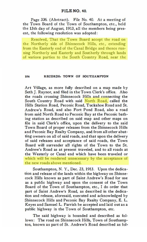
In the Southampton Records there was a File 40 from August 1913 that talked to dedication of a number of roads and trading of other roads to Peconic Bay Realty.  I've reproduced it below.  The first highlighted part describes in text a road through the Shinnecock Hills which it later refers to as the North Road.  Further down, where I've also highlighted, it refers to the North Road as a new road which the Town is accepting while giving older unused roads back to Peconic Bay Realty.  Based on this, I'd draw the conclusion that the North Highway as we know it in 1916, or today, was built closer to 1913 than to 1906.  Clearly, there were parts of the road there, probably in unimproved states. in 1903 and up until the new road, in its entirety, was built.  There was a section there in 1903, St Andrews Road, on which the Shinnecock Inn was built, but it must have been an unimproved road at the time.

Based on this file, it is clear that the new roads mentioned were built as private roads and then dedicated and released as public roads in 1913.  The trade-of was that Peconic Bay received a number of rights-of-way (public?) that were for roads that would be displaced by the new roads.


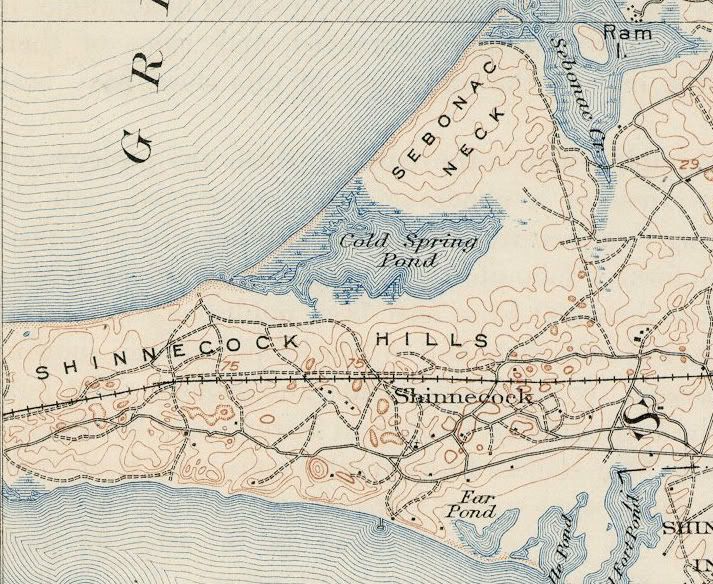
Here below is the 1903 USGS map of the Shinnecock Hills.  I think it is the most accurate from that era.


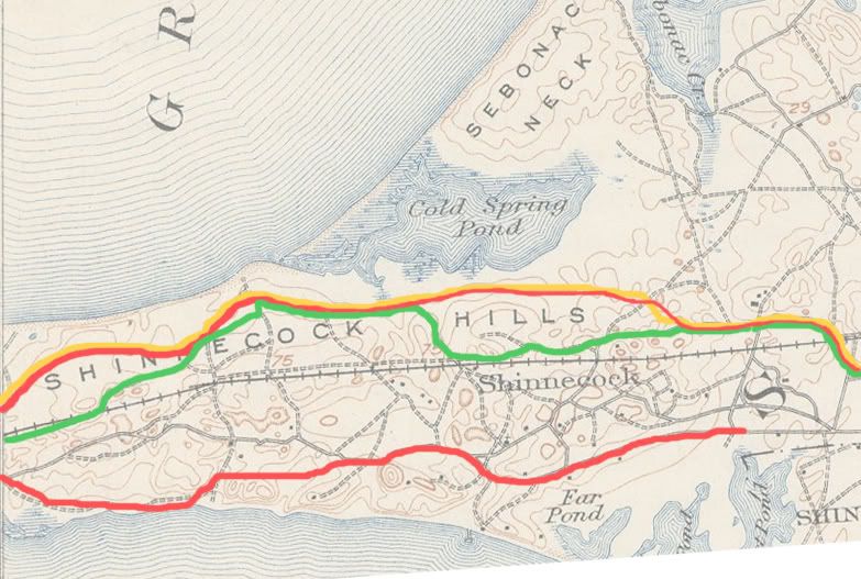
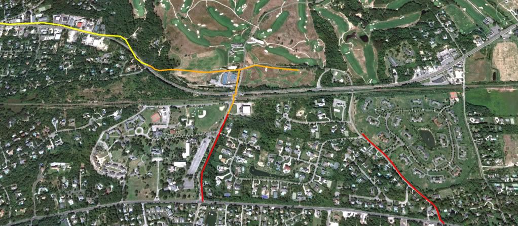
David has done a good job of overlaying the various maps from the era.  I just wanted to add this one below, which shows, in Mucci-green, the 1903 "North Highway" as Patrick has described it.  I've also added, in red, the North Road/Highway provided by the metes and bounds of the Southampton Records that Andy found.  And, I've added, in yellow, the 1916 Atlas map version of the North Highway.  Both are consistent with the current routing of the road, with one exception.  The eastern end that used to run through the Shinnecock Hills golf club, currently drops southerly and runs much closer to the LIRR tracks.  No doubt a result of one of the later rebuilds of SH.

It should be noted that all the road rights-of-way were designated as 50 feet wide, much wider than the actual roads were built then, or now.

It also appears that the South Highway was not a complete contiguous road either in 1903, but was by 1913.


On the next picture, I've plotted the metes and bounds for parts of St Andrews Road and Tuckahoe Road that were dedicated as public roads in 1913.  The orange parts are stretches that abut some part of the Shinnecock Hills Golf Club.  The measurements are quite precise.  They appear to match the related stretches on the 1916 Atlas map.  Unfortunately there is no mention of roads that abut other boundaries of the club.


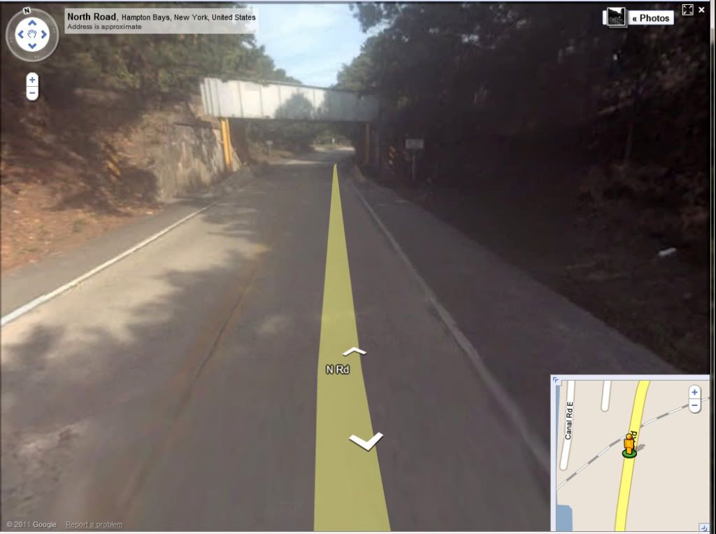
Finally, for Patrick, a picture of the still bustling  ;)  North Highway in the 21srt century.  Next time you're out that way, maybe you could stop and see if there is a dedication stone on that bridge from the year it was built?  Or, not.


« Last Edit: March 31, 2011, 12:04:40 AM by Bryan Izatt »

Mike Cirba

Re: The Creation of NGLA in Chronological, Contemporaneous News Articles
« Reply #1121 on: March 30, 2011, 07:19:49 PM »
Bryan,

That's absolutely tremendous work...thanks!

Two questions;

1) In your estimation, based on the position of the North "road" in 1906, would there have been enough width to route an "out and back" golf course heading west from about 200 yards from the west side of Shinnecock Inn, located south of Cold Spring Bay and north of the railroad tracks, and ending with it's westernmost point near the inlet (possibly even stretching further so that Peconic Bay was to the north) between the Shinnecock Station and Good Ground without having to contend with road congestion?   If I understand your map correctly the location I described would run north of the Muccian Green road.

2) From reading the metes and bounds from the 1913 dedication, it sounded as though the North road ran along the north border of the Shinnecock Hills Golf Club at that time.    Is that correct, and if so, could you show us precisely where that was and it's positioning in relation to NGLA?

Thanks again...great stuff.
« Last Edit: March 30, 2011, 07:22:51 PM by MCirba »

JESII

  • Karma: +0/-0
Re: The Creation of NGLA in Chronological, Contemporaneous News Articles
« Reply #1122 on: March 30, 2011, 07:24:54 PM »
Mike,

How far would you guess it was from the Shinnecock Inn to that section of Peconic Bay?

Jeff_Brauer

  • Karma: +0/-0
Re: The Creation of NGLA in Chronological, Contemporaneous News Articles
« Reply #1123 on: March 30, 2011, 07:31:53 PM »
Bryan,

I agree, great work. How many hours did you spend? I will bet they are less than all the uninformed arguments made here about those #$@(@ roads.  For what its worth, I always had the impression that the roads developed slowly, but faster after Peconic Bay started drawing their plans and selling lots.

It shouldn't have been a question as to whether a golf course would fit in that area.  It would be whether CBM had any idea of the plans when he suggested his first site to the realty company.  I suspect he went in there in summer of 1906, saying he wanted at least some waterfront land, and they rejected him because they were too far along with their plans to change (perhaps having already submitted plat plans and the like) but were perfectly willing to have NGLA as an amenity on land that had not been considered yet for development.

The whole argument about how idiotic Mike was for suggesting that area because of the roads seemed far fetched to me, given the timing of everything. 

And, it would still be interesting but not imperative to know where that site was!
Jeff Brauer, ASGCA Director of Outreach

Mike Cirba

Re: The Creation of NGLA in Chronological, Contemporaneous News Articles
« Reply #1124 on: March 30, 2011, 07:38:54 PM »
Jim,

No need to guess, actually.

David has shown us how today's NGLA actually traverses about 2 miles in each direction, plotted along the holes.

The following would assume a straigther routing, but the red line going east/west is 2 miles exactly.


Tags:
Tags:

An Error Has Occurred!

Call to undefined function theme_linktree()
Back