News:

This discussion group is best enjoyed using Google Chrome, Firefox or Safari.


DMoriarty

  • Karma: +0/-0
Re: My attempt at the Timeline
« Reply #1100 on: June 02, 2009, 07:59:39 PM »
Mike Cirba

Can you or anyone else explain what spefically tepaul plans on proving?   I've read the posts he references and it doesn't make sense to me.

Golf history can be quite interesting if you just let your favorite legends go and allow the truth to take you where it will.
--Tom MacWood (1958-2012)

Patrick_Mucci

Re: My attempt at the Timeline
« Reply #1101 on: June 02, 2009, 09:48:33 PM »

"I've asked you to provide the Metes and Bounds and I've asked you why you won't provide the metes and bounds.
Yet, you've answered neither."

Because Pat, the way this is getting resolved, and it seems to be close to being resolved already with Bryan and me without metes and bounds is a whole lot more interesting for all of us than just measuring metes and bounds at this point.

TE, that's your opinion, which might not be shared by everyone you think.
While it's an interesting exercise to try to piece the compenent dimensions together, it would save everyone a lot of time and unnecessary reading if you'd just provide the Metes and Bounds.


What we will learn here doing it this way---eg the story this will tell us all doing it this way is how the unique circumstances of what happened at Merion in this entire timeline are going to show us how neither me or Bryan or even a professional surveyor is needed to measure metes and bounds to come to the exact acreage results.

That's NOT the object or focus of the discussion.
This isn't amateur hour at the Apollo.
This isn't an exercise or thread on how to survey or measure.
Cut through the B.S. and just give him the metes and bounds


The actual measurements using all the exact metes and bounds can be done later by Bryan or anyone else who can do what he does AND a professional surveyor using the exact metes and bounds and I guarantee you they will ALL show the same results that I came do some days ago and Bryan came to last night.

If that's the case, why withhold the Metes and Bounds ?
What's your reason for doing so ?  To test Bryan's competence ?


I believe there is virtually no way they can't come to those same results given some pretty interesting events within the timeline we are using for this!

Again, that's YOUR opinion.
Give him the metes and bounds and lets get on with it.
I don't know Bryan from a hole in the wall, but, I trust his ability to measure, his objectivity and his integrity.
STOP MAKING EXCUSES AND GIVE HIM THE METES AND BOUNDS.


It is pretty cool how this is playing out between us; you'll see eventually I guess, that is if you really aren't as dense as I think you are.  ;)

TE, I don't have time for games, I'm goal oriented, a "bring me the baby without the labor pains" type.
I don't want to see, "EVENTUALLY",  I want to see now, and you're game playing is impeding that.


For starters you might begin by trying to understand what happened in that excercise depicted in posts #652, #656 and #670. From there you might try to understand how Bryan arrived at the results he produced on here last night!   8)


While I trust Bryan's ability, I'd rather he proceed with confirmed co-ordinates, the Metes and Bounds.
That eliminates margins of error.

Please, stop the silliness and give the info to him.
Your refusal to do so makes EVERYONE suspicious of your intent.
Everyone except Wayno that is.  ;D


JESII

  • Karma: +0/-0
Re: My attempt at the Timeline
« Reply #1102 on: June 02, 2009, 10:21:52 PM »
Tom,

Is there more to your most recent hypothesis on the land swap than the Thompson Resolution which resulted in the purchase of three acres for a sum of $7,500?

Are you expecting to complete the revelation you've aparently had about Bryan's chart illustrating the same three acre addition to total land that you've been talking about for a week or two? In other words, what specifically do you think "exchange land purchased for land adjoining and to purchase an additional three acres..." means? Please tell us it does not merely mean the purchase of three acres somewhere on the property...

Mike_Cirba

Re: My attempt at the Timeline
« Reply #1103 on: June 02, 2009, 10:42:29 PM »
Sully,

That's a good question for Tom Paul and I have one for David Moriarty, as well.

David,

If there is additional evidence that blueprints of the course existed prior to January 1911 that are included as part of the agricultural letters, and you think they prove that the course was routed prior to WIlson's involvement...

...then what the f*ck are you waiting for man?   Let's see them!   
« Last Edit: June 02, 2009, 11:25:40 PM by MCirba »

Patrick_Mucci

Re: My attempt at the Timeline
« Reply #1104 on: June 02, 2009, 10:45:40 PM »
Sully,

That's a good question for Tom Paul and I have one for David Moriary, as well.

David,

If there is additional evidence that blueprints of the course existed prior to January 1911 that are included as part of the agricultural letters, and you think they prove that the course was routed prior to WIlson's involvement...

...then what the f*ck are you waiting for man?   Let's see them!   

Mike,

I hope you ask the same question of TEPaul when it comes to the Metes and Bounds, afterall, you did promise Bryan Izatt that you'd drive to Media, PA and obtain the readings for him. ;D

TEPaul could save you the trip, time and trouble by "letting us see them".
Like you said, what the fook is he waiting for ?


Mike_Cirba

Re: My attempt at the Timeline
« Reply #1105 on: June 02, 2009, 10:50:51 PM »
Patrick,

I've told Tom Paul that I do understand the value in both him and Bryan arriving at the same conclusion without having the same set of data...I think it's important to see how that plays out.

I've also told Tom Paul that if this isn't resolved by Bryan by this weekend, I'll walk to freaking Media to get those prints to Bryan.

DMoriarty

  • Karma: +0/-0
Re: My attempt at the Timeline
« Reply #1106 on: June 02, 2009, 10:58:59 PM »
Mike Cirba,

You claim you understand what TEPaul is trying to prove with the metes and bounds.  Great.

Can you specifically describe to us what he is trying to prove?

Because I really have no clue.

Thanks.
Golf history can be quite interesting if you just let your favorite legends go and allow the truth to take you where it will.
--Tom MacWood (1958-2012)

Mike_Cirba

Re: My attempt at the Timeline
« Reply #1107 on: June 02, 2009, 11:05:56 PM »
Mike Cirba,

You claim you understand what TEPaul is trying to prove with the metes and bounds.  Great.

Can you specifically describe to us what he is trying to prove?

Because I really have no clue.

Thanks.

David,

You say you have proof that the course was routed and existed on blueprint prior to Wilson's involvement.

You've been at this for five years.  YOU are the one challenging the history of this great course.

The burden of proof is your's.

Let's see it,.

Joe Hancock

  • Karma: +0/-0
Re: My attempt at the Timeline
« Reply #1108 on: June 02, 2009, 11:10:52 PM »
Mike Cirba,

You claim you understand what TEPaul is trying to prove with the metes and bounds.  Great.

Can you specifically describe to us what he is trying to prove?

Because I really have no clue.

Thanks.

David,

You say you have proof that the course was routed and existed on blueprint prior to Wilson's involvement.

You've been at this for five years.  YOU are the one challenging the history of this great course.

The burden of proof is your's.

Let's see it,.

This, in a nutshell, is how ineffective this discussion has become. The answer doesn't even address the question.

Joe
" What the hell is the point of architecture and excellence in design if a "clever" set up trumps it all?" Peter Pallotta, June 21, 2016

"People aren't picking a side of the fairway off a tee because of a randomly internally contoured green ."  jeffwarne, February 24, 2017

Mike_Cirba

Re: My attempt at the Timeline
« Reply #1109 on: June 02, 2009, 11:14:25 PM »
Mike Cirba,

You claim you understand what TEPaul is trying to prove with the metes and bounds.  Great.

Can you specifically describe to us what he is trying to prove?

Because I really have no clue.

Thanks.

David,

You say you have proof that the course was routed and existed on blueprint prior to Wilson's involvement.

You've been at this for five years.  YOU are the one challenging the history of this great course.

The burden of proof is your's.

Let's see it,.

This, in a nutshell, is how ineffective this discussion has become. The answer doesn't even address the question.

Joe

Joe Hancock,

I agree completely.

Especially since David's post to me that you copied above was in response to my asking him;

David,

If there is additional evidence that blueprints of the course existed prior to January 1911 that are included as part of the agricultural letters, and you think they prove that the course was routed prior to WIlson's involvement...

...then what the f*ck are you waiting for man?   Let's see them!   


I hope at this point Joe that you're unbiased enough to call out anyone on this thread who disengenously claims they have PROOF that will break this logjam and then purposefully diverts discussion elsewhere.   ::)

« Last Edit: June 02, 2009, 11:19:57 PM by MCirba »

DMoriarty

  • Karma: +0/-0
Re: My attempt at the Timeline
« Reply #1110 on: June 03, 2009, 12:26:16 AM »
Mike,

See post 1181.  I asked you the same question and you ignored it.   I re-asked it later and you ignored it again. 

As for the blueprints, see my description of the Ag letters, somewhere above.    What is it that you demand I provide you?  The Ag letters?  I'd be glad to provide them to everyone if we can figure out an efficient way to do it.

Will you please answer my question because I really have no idea what TEPaul is trying to prove. 

Seriously, can anyone explain this?
Golf history can be quite interesting if you just let your favorite legends go and allow the truth to take you where it will.
--Tom MacWood (1958-2012)

Bryan Izatt

  • Karma: +0/-0
Re: My attempt at the Timeline
« Reply #1111 on: June 03, 2009, 12:39:40 AM »
Bryan:

Your timeline above is very good but on your first inclusion "Before July, 1910" you're implying that an arrangement with certain members of the club with the 338 acre HDC tract took place before July, 1910 and you are using as your source president Evan's circular to the membership of Nov. 1910. In that circular Evans does not say there was an arrangement with certain members of the club with HDC on the 338 acres before July, 1910. From other records from the club it does say that this arrangement was agreed to in a number of negotiations and conferences between Lloyd and Connell that appear to have culminated in late Oct or early Nov. 1910. At that point, Lloyd put the situation in front of the board, they considered it, approved it and then notified the membership of it. Simultaneously Lloyd sent out his own circular to the membership about the real estate opportunity.

I wasn't trying to imply anything.  The fact that I wanted to capture was that the 338 acre tract had been "acquired" by HDC, presumably some time before July 1910, since there is reference to inspecting the property in July.

Bryan Izatt

  • Karma: +0/-0
Re: My attempt at the Timeline
« Reply #1112 on: June 03, 2009, 01:02:26 AM »
Bryan;

I'm impressed. I do have a few minor questions but nevertheless go back and read my posts #652 and #656.

Look how close we are!!

You said above:

"Based on the information available, so far, I've plotted out the boundaries and calculated the areas of the plots of land we're interested in.  The obvious caveat is that, without the metes and bonds from 1910 and 1911 (Tom), the plot is approximate."


It may still be approximate but I can tell you that you have now gotten the important and relevent acreage tracts (plots) and the total very close to what the actual metes and bounds determine them to be!   Are you trying to say that you  have actually used the metes and bounds to determine the acreages?  Are you just teasing us along?

Tell me what you think you've learned or are learning from all this information taken together and I'll tell you what I think I've learned by that excercise contained in #652 and #656 that pretty much matches your post and drawing above. I think there may be a later post by me on this that explains a few other things about all this (the excercise contained in posts #652 and #656) even better. I'll see if I can find it.


Tom,  I would have been astounded if the numbers hadn't turned out to be close.  But in this game close doesn't cut it, when we could be exact with the metes and bounds.  What have I learned?  That without the metes and bounds I don't have the precise information I need to determine which 3 acres were added between the two deeds. And, that the boundaries I have are imprecise because they don't add up to 161 acres.  An error of 2 acres in 161 is significant when we're trying to understand 3 acre deltas.

Bryan Izatt

  • Karma: +0/-0
Re: My attempt at the Timeline
« Reply #1113 on: June 03, 2009, 01:12:32 AM »
Bryan:

By 1913 Merion could have added a few little pieces on the southwest boundary of the property but I'm not sure they had done that yet. I'll check the Merion deed and survey run to see. It would probably be better not to use 1913 but rather the total acreage when the deed was transfered from Lloyd to MCCGA in July 1911 and that deed shows a total acreage of 120.1, not 123.

Tom,

I think you have not understood what I'm doing.  I have tried to determine where the boundaries were and then calculate the acreages from the boundaries.  The sources I've used are the metes you and David provided for the Haverford College boundary; the 466' dimension of the north end of the Johnson farm that you provided (even though it was blurry); and the 1913 RR map (which may have some dimensional issues).  So, the fact I came out to 163 acres or 123 acres or whatever should rightfully be taken with a grain of salt.  If I had the metes and they came out to 161 and 120.1 acres, I'd be really happy that I know where the boundaries were and what the acreages were.  From there maybe then I could begin to speculate as to what was swapped for what.  I'm trying hard not to jump the gun like many others, you included. I'm going to try to continue to work from the metes up.  If you want to work from the acreages down, have fun.


Bryan Izatt

  • Karma: +0/-0
Re: My attempt at the Timeline
« Reply #1114 on: June 03, 2009, 01:20:54 AM »
Mike Cirba:

Are you beginning to understand what is going on here? It seems like Bryan and I are reaching almost identical results somewhat independent of one another and we are doing it not even using the metes and bounds on the entireties of those two important deeds that bookend this important timeline.

The reason for this is the unique event circumstances contained in this project's timeline that happen to be reflected in those two book-end deeds.

It looks like Bryan and I already have come to the same measurment results in those important areas that make up the totals. I will virtually guarantee you that either a professional surveyor or Bryan once the metes and bounds are totally measured will match the results Bryan and I arrived at.

Given some of the unique circumstances of this whole thing it appears there is virtually no way they can't all match and that would be pretty amazing considering we actually did it without measuring all of it.


Tom,

I think you are making a big leap in co-opting me into your "conclusions".  For the record the only thing I'll agree to is that we both came up with 18 acres for the JW area.  You did it by assuming an acreage for the RE land.  I did it by assuming some boundaries based on questionable data.  It could be a fluke that we arrived at the same number.  Only the metes and bounds know for sure.

Pat,

Thanks for the continuing support on the need for the metes and bounds to see the light of day here on GCA.

Do you suppose there's a big ugly skeleton in the metes closet?   ;D Or, maybe there are no metes in the closet.  ???


Bryan Izatt

  • Karma: +0/-0
Re: My attempt at the Timeline
« Reply #1115 on: June 03, 2009, 01:38:11 AM »
"I've asked you to provide the Metes and Bounds and I've asked you why you won't provide the metes and bounds.
Yet, you've answered neither."


Because Pat, the way this is getting resolved, and it seems to be close to being resolved already  I don't agree that it's resolved   with Bryan and me without metes and bounds is a whole lot more interesting for all of us than just measuring metes and bounds at this point.  I'm glad you find it "interesting".  I just find it frustrating.  What we will learn here doing it this way---eg the story this will tell us all doing it this way is how the unique circumstances of what happened at Merion in this entire timeline are going to show us how neither me or Bryan or even a professional surveyor is needed to measure metes and bounds to come to the exact acreage results. Tom, this is nonsensical.  Why would anyone want to infer boundaries and acreages from "unique circumstances" and "timelines" when you could simply measure them from metes and bounds and know they are accurate.  Do you enjoy trying to play puppet-master?

The actual measurements using all the exact metes and bounds can be done later by Bryan or anyone else who can do what he does AND a professional surveyor using the exact metes and bounds and I guarantee you they will ALL show the same results that I came do some days ago and Bryan came to last night. I believe there is virtually no way they can't come to those same results given some pretty interesting events within the timeline we are using for this!

It is pretty cool how this is playing out between us; you'll see eventually I guess, that is if you really aren't as dense as I think you are.  ;)

For starters you might begin by trying to understand what happened in that excercise depicted in posts #652, #656 and #670. From there you might try to understand how Bryan arrived at the results he produced on here last night!   8)


Bryan Izatt

  • Karma: +0/-0
Re: My attempt at the Timeline
« Reply #1116 on: June 03, 2009, 01:49:35 AM »
David,

What do you think it means if Bryan comes up with the exact same numbers as TePaul WITHOUT having the Metes and Bounds, but by simply following the agreed-upon Timeline?  The only number that is the same is the area of JW - 18 acres.  It might mean that I guessed right.  Or, that the RR map is really damn accurate.  Or, that Tom can add acreages, knowing what the area of RE was. Or, that it was a fluke. Or, that the area of JW was really 18 acres. 

Would you see any significance to that??  No.

Bryan Izatt

  • Karma: +0/-0
Re: My attempt at the Timeline
« Reply #1117 on: June 03, 2009, 01:56:00 AM »
Patrick,

I've told Tom Paul that I do understand the value in both him and Bryan arriving at the same conclusion without having the same set of data...I think it's important to see how that plays out.  I'm glad that you and Tom understand the value, because I do not.  >:(

I've also told Tom Paul that if this isn't resolved by Bryan by this weekend, I'll walk to freaking Media to get those prints to Bryan.  Why would Tom want you to do that?  In any event, I have another offer that I'm pursuing to get the metes and bounds, so you can put away your walking shoes for the moment.

Bryan Izatt

  • Karma: +0/-0
Re: My attempt at the Timeline
« Reply #1118 on: June 03, 2009, 02:06:20 AM »
Since Tom and Wayne are ostensibly off on the search for the golden fleece (topo map) I thought I'd help out with this one.  Of course, I'm not sure how accurate the roads are, or how useful it would be for determining acreages or land swaps?  And, of course it's not signed by Francis or Wilson or anybody.   :(


Mike_Cirba

Re: My attempt at the Timeline
« Reply #1119 on: June 03, 2009, 07:36:55 AM »
Bryan,

Do you need me to help?  It's tough to tell from your response.  I'm willing.

David,

Can't you just transcribe the part where the ag letters prove that Wilson was working with a pre-routed golf course blueprint from prior to Feb 1911?

I trust you to type it accurately and that should suffice to end this discussion if it exists..
« Last Edit: June 03, 2009, 10:23:21 AM by MCirba »

TEPaul

Re: My attempt at the Timeline
« Reply #1120 on: June 03, 2009, 09:11:25 AM »
Tom,

I think you have not understood what I'm doing."


Bryan:

Perhaps, and that's why I asked you yesterday how you went about it. I was interested of course because you came so close to the incremental acreage numbers I did and I haven't tried to measure any metes and bounds off these two deeds. It looks to me like the following explains well how you went about it.


  "I have tried to determine where the boundaries were and then calculate the acreages from the boundaries.  The sources I've used are the metes you and David provided for the Haverford College boundary; the 466' dimension of the north end of the Johnson farm that you provided (even though it was blurry); and the 1913 RR map (which may have some dimensional issues).  So, the fact I came out to 163 acres or 123 acres or whatever should rightfully be taken with a grain of salt.  If I had the metes and they came out to 161 and 120.1 acres, I'd be really happy that I know where the boundaries were and what the acreages were.  From there maybe then I could begin to speculate as to what was swapped for what.  I'm trying hard not to jump the gun like many others, you included. I'm going to try to continue to work from the metes up.  If you want to work from the acreages down, have fun."


TEPaul

Re: My attempt at the Timeline
« Reply #1121 on: June 03, 2009, 09:31:41 AM »
"Tom,

Is there more to your most recent hypothesis on the land swap than the Thompson Resolution which resulted in the purchase of three acres for a sum of $7,500?

Are you expecting to complete the revelation you've aparently had about Bryan's chart illustrating the same three acre addition to total land that you've been talking about for a week or two? In other words, what specifically do you think "exchange land purchased for land adjoining and to purchase an additional three acres..." means? Please tell us it does not merely mean the purchase of three acres somewhere on the property..."


Sully:

Good questions indeed.

What do I think the exchange of land purchased for land adjoining and the purchase of an additional three acres means?

I think the sum total of it (The Thomspon Resolution) means the Francis land swap idea and how it actually happened to fix those last five holes that Francis' story says were difficult to get in. In other words, I think the Francis land swap IS the Thompson Resolution (and the Thompson Resolution is the Francis land swap) as the board of Governors of MCC formally approved it (the Francis land swap) so that it could be reflected in the metes and bounds of the deed that Lloyd would transfer to MCCGA in July, 1910.


"Please tell us it does not mean the purchase of three acres somewhere on the property?"


I think that's precisely the point. It does not and frankly cannot mean the purchase of three acres just anywhere on the boundaries of the property---eg it pretty much has to mean an exchange and purchase in a defined area and on a specific boundary line. I'll explain the reason why that is below. I believe it means the exchange for land already puchased for land adjoining AND an additional three acres for $7,500 in a very specific and defined area of the property and I think that is really important to both isolate the beginning and ending linear dimension of that area and prove that is the only area the exchange and additional purchase could have happened.

That’s just for starters. Are you with me so far about why this is important to do?
« Last Edit: June 03, 2009, 09:34:46 AM by TEPaul »

TEPaul

Re: My attempt at the Timeline
« Reply #1122 on: June 03, 2009, 09:44:39 AM »
Mike, Bryan and Sully:

Just to go back and review;

As I see this entire Francis land swap issue (the idea, the seeking of Lloyd's permission and the fix and approval) it has two separate although perhaps somewhat interrelated questions to it;

1. When did it actually happen (did it logically have to be within a particular timeframe or not)?
2. Specifically WHERE (some defined area?) and HOW it happen (was IT the exchange and purchase of the Thompson Resolution since there was no other boundary adjustment to this property in this timeframe?)?

Since nothing that was left that is available to us today specifically addresses those answers I think we just have to use ALL the material we know available to us surrounding this entire timeframe (June 1910 to July 1911) to determine what are the most logic answers to those questions. And I also believe because of a few unique circumstances and ramifications to this entire project and its boundary lines ALL the surrounding material can lead us to some fairly defined answers to these question, and certainly the question of in what specific area it had to have occured.

While saying all this I do admit there is still one "asset" missing that could and would prove to us exactly how the Francis fix was accomplished up and down what would be the delineation of Golf House Road and that is one of those topographical contour maps the Wilson committee was working on which had to have had a specific and measurable boundary delineation on it which was the proposed Golf House Road.

Would you agree?
« Last Edit: June 03, 2009, 10:22:29 AM by TEPaul »

Mike_Cirba

Re: My attempt at the Timeline
« Reply #1123 on: June 03, 2009, 09:52:03 AM »
Because our discussion is becoming so fragmented, I thought it best to move this response over here on this more comprehensive thread because I think it's important to understanding how the original golf course land for Merion was allocated.

David Moriarty and I had been going back and forth about the meaning of a series of articles that Joe Bausch produced re: the origins of NGLA, and he rightfully corrected me that they proved exactly what he said they did;  that NGLA first "optioned" 200 or so acres out of a possible 400+, then spent several months on the ground (planned to be 5, could have been up to 11) routing their golf course and laying out the holes) BEFORE committing on the exact boundaries of which 200 acres to purchase.   

The articles also show that originally Macdonald wanted to have some portion of that land go to real estate lots for early subscribers and believed the golf course would require about 110 acres, leaving 100 for the lots.   Obviously that changed over time, as although 205 acres were purchased, the golf course portion took up much more acreage (somewhere between 150 and 180 acres) than originally conceived, and no real estate component was ever built.

With all that said, here's what I wrote to David;

David,

My mistake, and I see what you are saying.  Thank you for bearing with my misunderstanding. 

With your explanation, I can see that they first "optioned" 200 acres of the 400+ and then spent the next five or more months determining the routing and planning the holes before committing to the specific boundaries of the final purchase.  That makes absolute sense to me.

Where I'm still struggling however, is how this is in the least bit analogous to what was done at Merion?

For instance, we now know that when Macdonald "optioned" the 200 acres he did so with the idea that some large portion of it would be used for subscriber real estate lots.   

In other words, in December 1906 he committed to buy considerably more land than he thought he needed for the golf course, which at first he  figured would be about 110 acres, leaving another 100 for real estate.

We know he eventually used quite a bit more land than he originally estimated for golf as the planameter results from what you and Jim Kennedy figured indicate the golf course occupies somewhere between 150-180 acres of the 205 Macdonald eventually purchased.

That probably makes sense, as some of the width and strategic options we know Macadonald wanted to achieve required quite a bit of acreage, and even though the course is only "two-wide" out and back in terms of routing, most of the fairways occupy generous portions.

I'm also wondering if some other complications around the real estate plans made that a less enticing scenario as the course was several years in the making.   Do you know why he eventually scrapped real estate plans?   Did they just eventually determine that they didn't have enough lots left after desiging the golf course or were there other factors?

It would also seem from the articles that perhaps more credit for the routing and hole designs should go to Emmet and Travis than previously believed?   Do we know if they were both involved as planned through the orginally proposed 5 month onsite design cycle, which seemingly culminated in the final purchase of 205 acres sometime later in 1911?

The reason I say I don't see any analogy to Merion is pretty straightforward.

In the case of NGLA, you've been telling me, and I now clearly see that the NGLA design committee spent five months (or more if the actual purchase date of November 1907 is accurate), working probably daily on the ground, coming up with the routing and hole plans for the course at Southampton before finalizing their purchase.

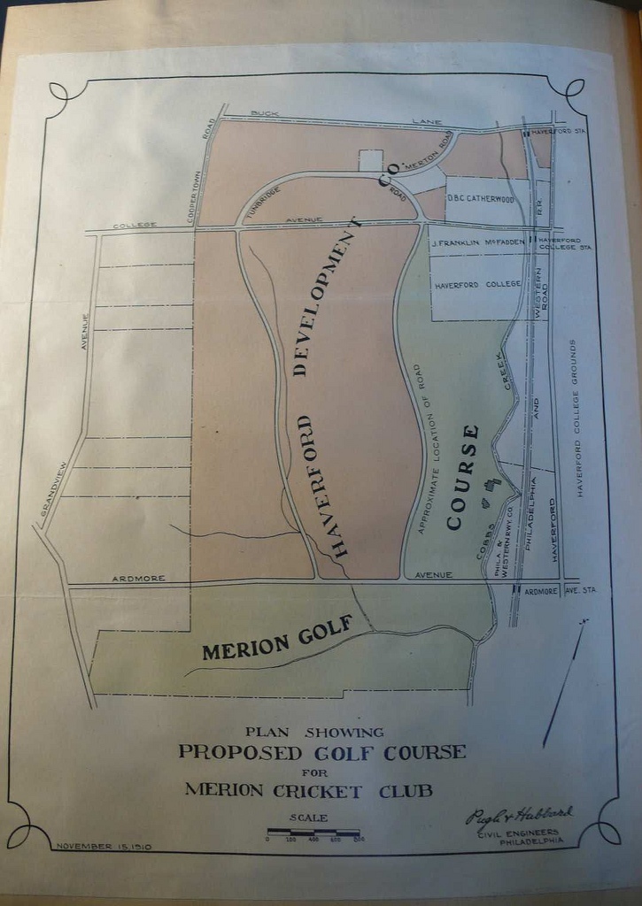
At Merion, the location of the 117 acres originally allocated for the golf course there out of the 338 acres that HDC held seem to have already been determined based on much less time, effort, and specific architectural purpose.  It also seems much more arbitrary.

For instance, from all indications that 117 acres Merion purchased was made up of taking all of the Johnson Farm land south of Ardmore Avenue, adding the southwestern adjoining Dallas Estate, and then grabbing most of the Johnson Farm land north of Ardmore Avenue that ran from Ardmore Ave to College Avenue north, with a transitory, proposed, "approximate" boundary between the golf course and the land available for real estate that was going to be adjustable depending on the final routing of the golf course.

All of the rest of the HDC holdings was west and due north of the golf course.

The following pre-course map and the 1910 Land Plan illustrate what I mean;


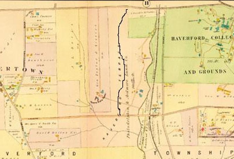
While we know that Barker did some type of one-day routing for the developer Connell, we also know that Macdonald and Whigham's single day visit that same month only resulted in a single-page letter largely expressing concerns as to whether the acreage was enough for a first-class course, as well as agronomic concerns with the inland clay-based soils.

There is no record of anyone, much less either M&W or Barker, doing anything else on the grounds between June 1910 and the final land purchase in the Nov/Dec 1910 timeframe.

If there was some parallel to NGLA prior to the finalized purchase, one would expect that records would exist of committees and teams of men streaming across the hundreds of HDC acres looking to locate a golf course would exist, and that those committees would seek out the best land of the 338 HDC acres for golf...not just some arbitrary geographicallly-based boundary.

Instead, it's only after the land was purchased at Merion, again in a very sensible fashion simply divding the portions for what made sense to support the combined goals of golf and real estate (as well as factoring in some realites about the golf course...the possibility of using the existing barn as a clubhouse, the wish to have the course located near the railroad, the possibilities of the quarry and creeks for hazards), that a committee was created to explore how best to use that land, spent months on the ground going through every conceivable golf plan, and then asking for M&W's best advice on which of those plans made the most sense and had the greatest golfing potential.

I really do think it's that simple.


« Last Edit: June 03, 2009, 10:19:24 AM by MCirba »

Mike_Cirba

Re: My attempt at the Timeline
« Reply #1124 on: June 03, 2009, 09:59:12 AM »
Mike, Bryan and Sully:

Just to go back and review;

As I see this entire Francis land swap issue (the idea, the seeking of Lloyd's permission and the fix and approval) it has two distinct and perhaps somewhat interrelated questions to it;

1. When did it actually happened (did it logically have to be within a particular timeframe or not)?
2. Specifically WHERE (some defined area?) and HOW it happen (was it the exchange and purchase of the Thompson Resolution since there is not other boundary adjustment to this property in this timeframe?)?

Since nothing that was left that is available to us today specifically addresses those answers I think we just have to use ALL the material we know available to us surrounding this entire timeframe (June 1910 to July 1911) to determine what are the most logic answers to those questions.

Would you agree?

Tom,

I think all of us are hoping that a comparison of the maps shows us something a bit more definitive than trying to determine whose "logic" is better as we know the circuitous, infinite loop that will create.

Are we at the point where we think a metes and bounds comparison of the 1910 Francis Deed and the 1928 Merion boundaries needs to be fleshed out?

I thought perhaps Bryan was backing into the answer similar to where you seem to be going but his answers to your question from last night indicate that's not the case.

I think the one simple question I'm left with at this point is simply, are the boundaries of the area along the northwestern boundary of the golf course (along Golf House Road) different between the 1910 deed and 1928 land plan?

Am I missing something?
« Last Edit: June 03, 2009, 10:10:44 AM by MCirba »

Tags:
Tags:

An Error Has Occurred!

Call to undefined function theme_linktree()
Back