Mike,
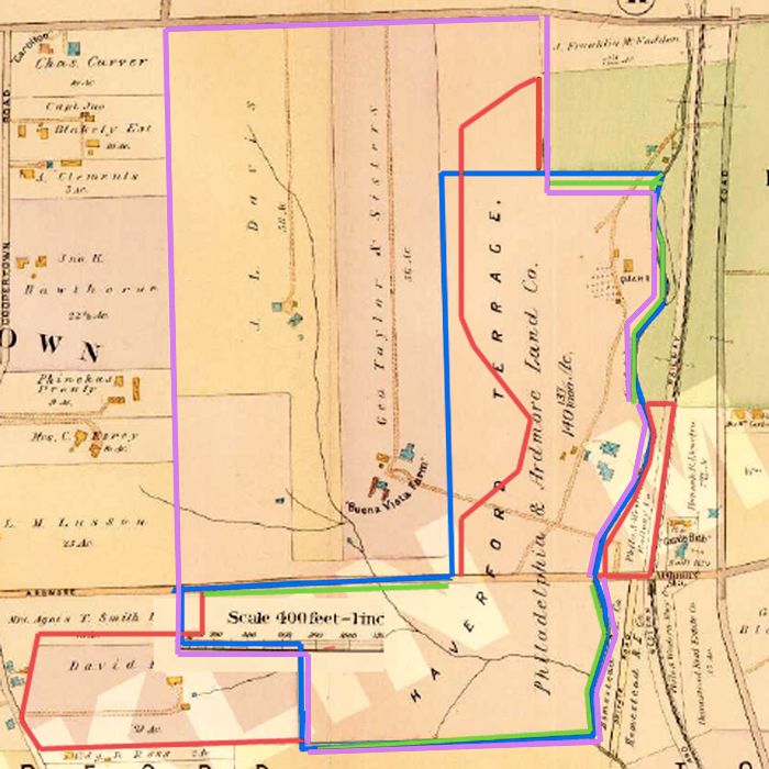
You like graphics so here is the 1908 map which I believe shows what was offered and what they ended up with. It is obviously not meant to be exact.

1. The Purple line represents the border of the land that HDC either owned or had an option on at the time they made their offer to MCC (excluding the land off the map to the north)
2. The Blue line represents the border of what I believe were the approx 100 acres that were originally offered.
3. Together, the Red and Green lines represent the borders of what was ultimately purchased by MCC.
3.a. The Red lines represents the portions of the border that differed from what was offered.
3.b. The Green lines represent the portions of the border that followed what was originally offered.
As you can see, they did NOT follow what was originally offered:
1. Francis noted that they did not need land west of the present course so they didn't purchase it.
2. Francis noted that they did need the 130 x 190 yard parcel west of Haverford College so they expanded their purchase up there.
3. M&W noted that MCC should purchase the land behind the clubhouse to use in the golf course so the secured that by lease.
4. HDC owned or had an option on plenty of land West of the current course, but according to Francis they didn't have interest in the land west of the current golf course. HHB, M&W, someone else, or some combination added the Dallas Estate which was great.
These are some of the changes to the borders made to suit the golf course. I am not even sure why this is arguable.