News:

Welcome to the Golf Club Atlas Discussion Group!

Each user is approved by the Golf Club Atlas editorial staff. For any new inquiries, please contact us.


MCirba

  • Karma: +0/-0
Re: Ron Whitten on Shinnecock
« Reply #325 on: July 02, 2015, 03:54:28 PM »
Jim,

You're right, I am, and that's because of the way Francis described things.   

I read Francis quite literally and I think they knew basically what they wanted for each of the final five holes and were having trouble fitting them due to the narrow corridor.

They certainly knew where they wanted to locate the 16th green because within a day or two they were blasting the top of the quarry hill "so that the green could be built as it is today".   Once you know that hole's location as the midpoint of the final five, is it really so hard to conceive of the others?

I find it difficult to believe they would have identified that location if they were working under the previous pre-Francis-brainstorm assumption that the land for their course ended just beyond the quarry at the southern boundary of the Haverford College land.  Given those constraints, where exactly would they be coming at it from and where would they go from there?


Take a look again at what they were dealing with here and how they "swooped" land in near the clubhouse and had to bust it out around the quarry.   In fact, the dimensions of the road looks to virtually parallel the shape of the quarry.    If the land they were working with really ended just beyond the quarry prior to Francis brainstorm they'd have no prayer of creating anything like five holes in that space, much less knew where they'd put the 16th green within a day or two.

Also, to put Mr. Lloyd back into the picture, according to your understanding he also owned all the land of the Johnson Farm north of the quarry prior to November 1910 so why would this have even been an issue?

« Last Edit: July 02, 2015, 04:13:50 PM by MCirba »
"Persistence and determination alone are omnipotent" - Calvin Coolidge

https://cobbscreek.org/

DMoriarty

  • Karma: +0/-0
Re: Ron Whitten on Shinnecock
« Reply #326 on: July 02, 2015, 04:13:03 PM »
Pretty funny that Mike get himself to accurately measure to all the way to the edge of the road, much less the middle of the road, which was the property line.
Golf history can be quite interesting if you just let your favorite legends go and allow the truth to take you where it will.
--Tom MacWood (1958-2012)

JESII

  • Karma: +0/-0
Re: Ron Whitten on Shinnecock
« Reply #327 on: July 02, 2015, 04:22:03 PM »
Mike,


If you read Francis at all literally you would not translate his words describing the area of the 15th green and 16th tee to mean 14th green and 15th tee. You would also probably not misunderstand his description of swapping land owned for land not owned to mean they redirected a hypothetical road with several gives and takes down the length of it and a net loss of acreage for the golf course...

MCirba

  • Karma: +0/-0
Re: Ron Whitten on Shinnecock
« Reply #328 on: July 02, 2015, 04:36:13 PM »
Pretty funny that Mike get himself to accurately measure to all the way to the edge of the road, much less the middle of the road, which was the property line.

David,

Would it make you happy if I gave you another 15 feet and we'll call it 95 yards?
"Persistence and determination alone are omnipotent" - Calvin Coolidge

https://cobbscreek.org/

DMoriarty

  • Karma: +0/-0
Re: Ron Whitten on Shinnecock
« Reply #329 on: July 02, 2015, 04:59:19 PM »
For those wondering what the Francis meant when he said that the property looked like a capital "L" before the swap, here is a closeup of a section of the Mueller Good Roads map published in 1913, rotated 90 degrees.  Note: I have no idea from where the information on this map came, and as I said it wasn't published until 1913.

This rendering is interesting because the golf RR land is not shown as part of the course, and because the "Francis swap" land is not part of the course, and because the middle of golf house road bows away from the clubhouse rather than toward it.  (And of course the area across Ardmore is the wrong shape.)

If Francis was looking at a map like this, then it is easy to understand why he would have wanted to trade the land across from the clubhouse for the land next to the College property.  As he said, adding the property next to the College land enabled him to fit the 15th green and 16th tee, and the land west of the course didn't fit in any layout anyway.
___________________________________________________________


Would it make you happy if I gave you another 15 feet and we'll call it 95 yards?
No. I measured it at about 115 yards.  Bryan measured in the past at about 115 yards.  I've duplicated Bryan's methodology above and it looks about right to me. You are kidding yourself if you think that area wasn't wide enough for a green and a tee.   
« Last Edit: July 02, 2015, 05:04:02 PM by DMoriarty »
Golf history can be quite interesting if you just let your favorite legends go and allow the truth to take you where it will.
--Tom MacWood (1958-2012)

Bryan Izatt

  • Karma: +0/-0
Re: Ron Whitten on Shinnecock
« Reply #330 on: July 03, 2015, 04:14:27 AM »
Mike,

Re your statement:


Quote
I read Francis quite literally .....


What Francis wrote quite literally was that the land they could use was "about 130 yds. wide by 190 yds. long - the present location of the 15th green and 16th tee."  That's the rectangle I drew below.  I was reading Francis literally and placing a rectangle of those dimensions where he literally said it was.  At 130 yards wide it extends beyond the current road or the approximate road of the land plan.  For this literal reading of what he wrote it doesn't matter how wide the base is over to the road.  He didn't mention the road as a constraint.  He felt there was a need for a piece of land in that location that was 130 yards wide by 190 yards long. It fits there and it was all on the Johnson farm property, so presumably available for swapping.

You have so far not identified any other place where the land might have been, given a literal reading of what Francis wrote.  I don't believe there is any other location where it could be placed.

The land plan of November 15th shows a good part of that rectangle as part of the golf course property.  That implies to me that the swap was done before the plan.  It also implies to me that the location of the approximate road was identified after the swap. It also implies to me that by the time the plan was drawn they had some idea that they didn't need all of the 130 x 190 rectangle for the routing since there was little choice but to go up that narrow area and come back out - what turned into the latter half of the 15th hole and the tee and beginning of the 16th hole.


MCirba

  • Karma: +0/-0
Re: Ron Whitten on Shinnecock
« Reply #331 on: July 03, 2015, 09:54:13 AM »
David,

That's a very interesting map, distortions aside.    Thanks for sharing it.   If not part of the golf course, what would you call that green rectangle sitting atop the Johnson Farm property almost to College Avenue?   The Haverford College lot never extended that far west to my knowledge.

Bryan,

I'm not sure what I'm missing.   Of course a 130 yard by 190 yard wide rectangle would encompass the narrower width drawn on that map, right?   

What do you measure from the middle of the road to the border because I'm not sure how David says you're getting 115 yards.  Thanks.
"Persistence and determination alone are omnipotent" - Calvin Coolidge

https://cobbscreek.org/

DMoriarty

  • Karma: +0/-0
Re: Ron Whitten on Shinnecock
« Reply #332 on: July 03, 2015, 10:37:07 AM »
David,

That's a very interesting map, distortions aside.    Thanks for sharing it.   If not part of the golf course, what would you call that green rectangle sitting atop the Johnson Farm property almost to College Avenue?   The Haverford College lot never extended that far west to my knowledge.
Mike the green rectangle is the Haverford College property, which extends east off the bottom of the image.  On this map it was drawn as bordering the road.  Just like it would have been without the swap.
Quote
What do you measure from the middle of the road to the border because I'm not sure how David says you're getting 115 yards.  Thanks.
The 115 yard figure is from an old thread.  Bryan measured it at about 115 yards years ago.  One of the many times we've had this same conversation.
. . .
For whatever it is worth, the distance from the real 1910 boundary to the middle of the current Golf House Road is 115 yards.  Not 95 and not 130.
« Last Edit: July 03, 2015, 10:50:15 AM by DMoriarty »
Golf history can be quite interesting if you just let your favorite legends go and allow the truth to take you where it will.
--Tom MacWood (1958-2012)

MCirba

  • Karma: +0/-0
Re: Ron Whitten on Shinnecock
« Reply #333 on: July 03, 2015, 01:54:08 PM »
When did Haverford College buy the northernmost portion of the Johnson Farm all the way to Golf House Road?
"Persistence and determination alone are omnipotent" - Calvin Coolidge

https://cobbscreek.org/

DMoriarty

  • Karma: +0/-0
Re: Ron Whitten on Shinnecock
« Reply #334 on: July 03, 2015, 02:05:37 PM »
What are you talking about?   On the map I posted there are two rectangles up by the intersection of College Avenue and Golf House Road. 
   1. The rectangle closest to College Avenue (which is partially obscured by the bleed of the blue coloring of College Road) is not colored, and it was marked as owned by J. Franklin McFadden on the Nov. 1910 land plan then Lewis P. Geiger, Jr. on the 1913 road atlas.
   2. The second rectangle is the rectangle which was owned by Haverford College, and is presently the location of the driving range. The area south of this rectangle is the golf course.  On this map, there is no golf course west of this parcel.

Haverford College never purchased the northernmost part of the Johnson farm.  But Golf House road was originally intended to be adjacent to the Haverford College property. This map is drawn with Golf House Road tight to the border of the Haverford College land, just as it would have been had the swap not taken place.
« Last Edit: July 03, 2015, 06:19:48 PM by DMoriarty »
Golf history can be quite interesting if you just let your favorite legends go and allow the truth to take you where it will.
--Tom MacWood (1958-2012)

MCirba

  • Karma: +0/-0
Re: Ron Whitten on Shinnecock
« Reply #335 on: July 04, 2015, 09:41:32 AM »
David,

I'll have to look at it on a larger monitor when I get home.

On my phone it looks as though the width of the L above Ardmore Ave. Is over twice the width of the L south of Ardmore Ave which would be well over 600 yards wide. 

If so, I'm pretty sure that the rectangle of Johnson Farmland north of the Haverford College southern boundary would have been well within those parameters.

Do you have a copy of a larger area you can show that might indicate other reference points?  Thanks.
"Persistence and determination alone are omnipotent" - Calvin Coolidge

https://cobbscreek.org/

DMoriarty

  • Karma: +0/-0
Re: Ron Whitten on Shinnecock
« Reply #336 on: July 04, 2015, 01:40:53 PM »
Mike,  the width of area south of ardmore is not bound by an roads or anything else that would show up on a simple road map and as I already said, it is obviously the wrong shape.  So why would you choose that as your measuring stick?   

Here is a rough overlay of the good roads map with the 1913 atlas, using the existing roads as my guide. The maps don't line up perfectly but as you can see the location of the intersection between Golf House and College is fairly close.


But I'm not going to argue with you about this map. It is what it is. I am not making any claims about it.  Just noting that the road on this map shows what the golf course property might have looked like without the swap.
« Last Edit: July 04, 2015, 01:44:42 PM by DMoriarty »
Golf history can be quite interesting if you just let your favorite legends go and allow the truth to take you where it will.
--Tom MacWood (1958-2012)

MCirba

  • Karma: +0/-0
Re: Ron Whitten on Shinnecock
« Reply #337 on: July 06, 2015, 11:05:27 AM »
David,
 
I'm having trouble reading it but is today's "Golf House Road" called "Llewyllen Road" on that 1913 Atlas?
"Persistence and determination alone are omnipotent" - Calvin Coolidge

https://cobbscreek.org/

JESII

  • Karma: +0/-0
Re: Ron Whitten on Shinnecock
« Reply #338 on: July 06, 2015, 11:25:33 AM »
Certainly looks like it...what do you think?

JESII

  • Karma: +0/-0
Re: Ron Whitten on Shinnecock
« Reply #339 on: July 06, 2015, 12:03:09 PM »
Sorry Mike...misread your question. Llewelyn is written on an image of what was actually built. The Atlas roads were not built as depicted.

MCirba

  • Karma: +0/-0
Re: Ron Whitten on Shinnecock
« Reply #340 on: July 06, 2015, 12:08:00 PM »
I don't know Jim, I don't recall it ever being mentioned here in previous discussions.   The first mention I can find of "Golf House Road" is 1915, and I seem to recall some others back when saying that road was never built until 1913 or so.
 
There are several oddities about that map as David mentioned, and I'm really trying to determine if we can glean anything useful or revealing from it.   For instance, I thought perhaps the plotting of the map possibly well preceded that 1913 date, back to the 1910 or 1911 discussion/debate we've been having here about the timing of the Francis Exchange.   However, I was able to find the map David did and it also includes the land of the Merion West course which wasn't acquired until 1913 and didn't open until May 1914.   
 
There are other strange anomalies, such as the Eaton property between the golf course and Ardmore Avenue (to the right of the 6th hole) showing as part of the golf course, but the 3 acres of railroad land does not. 
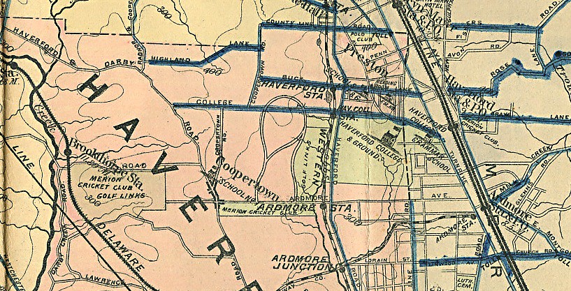


It would be interesting to track the history of those roads in the development.   On the map, the areas in BLUE are roads that have macadam and presumably all the rest are dirt tracks.   Since this map was apparently drawn a few years after the Pugh & Hubbard November 1910 map I'm not really sure how to interpret it, honestly.   
 
Did a dirt track road exist prior to the creation of the golf course and Haverford Road?   What were the dimensions?   Also, I recall this picture (showing the dirt road) being posted previously from the Sayers Scrapbook and seem to recall it was related to an Opening Day program but don't have the specifics on hand.   Obviously by Opening Day it would look something different than what's relayed on this map.   It's a head-scratcher, for certain.


One final point related to David's overlay is that it would be difficult to imagine a "like for like" acreage swap between the bulging land going west of the clubhouse as drawn to the triangle at the top.   I'd estimate the difference in acreage in a final swap given those dimensions would be giving up about 3x as much acreage given up near the clubhouse as would be gained near the top.
 
That's especially difficult to reconcile with the fact that Hugh Wilson told P&O that Merion had purchased 117 acres in his February 1911 letter only to have the Thompson Resolution in April 1911 requring a swap of land and the additional purchase of 3 more acres, finalized by Merion buying 120.01 acres of HDC land in July 1911.   
 
What do you think?
"Persistence and determination alone are omnipotent" - Calvin Coolidge

https://cobbscreek.org/

JESII

  • Karma: +0/-0
Re: Ron Whitten on Shinnecock
« Reply #341 on: July 06, 2015, 12:28:18 PM »
Don't really know what to make of it. Seems gathering data would take a great deal of time in those days so they would be outdated basically as soon as they were printed.


The shaping for the road bordering the golf course matches my thought of how Francis' words can make any sense at all.

MCirba

  • Karma: +0/-0
Re: Ron Whitten on Shinnecock
« Reply #342 on: July 06, 2015, 12:30:15 PM »
Is it possible that the dimensions drawn on that 1913 map came sometime after the November 1910 Pugh and Hubbard map showing an "Approximate Location of Road"?
 
It might be an interesting exercise to determine what the total acreage north of Ardmore Avenue on that map ending at the Haverford College line combined with the known acreage south of Ardmore Avenue adds up to.   Where's Bryan with his planometer?   :)
"Persistence and determination alone are omnipotent" - Calvin Coolidge

https://cobbscreek.org/

DMoriarty

  • Karma: +0/-0
Re: Ron Whitten on Shinnecock
« Reply #343 on: July 06, 2015, 12:45:50 PM »
"Llewellyn Road" is from the 1913 RR atlas which depicts the accurate location of the current road.  Apparently at some point early on Golf House Road was to be called "Llewellyn Road." (Llewellyn was a land owner who owned the parcel across the RR tracks from the 3 acres RR land.)  (The same company which produced the Good Road's Map also produced the RR Atlas, and the index for the RR Atlas is similar but not identical to the Good Road map. For example the RR Atlas includes the 3 Acres RR as part of the golf course, and has a more accurate shape for the Haverford College Parcel.)

The Fakers have claimed in the past that Golf House Rd was not built until later, but Golf House/Llewellyn Road was already in existence (and in its current location) as of July of 1911, as it was referenced in the Deed setting out the course boundaries. 

The colorized photo that Mike suggests was from Opening Day is actually from the fall of 1911 at the latest. It was printed on a program, menu, or invitation (I forget which) for a Holiday dinner celebration, 1911.

These old maps were created using a number of different sources, including (but not limited to) plat maps, land plans, and USGS surveys, so it is possible that the information on the Good Roads map came from an earlier version of the HDC land plan.
Golf history can be quite interesting if you just let your favorite legends go and allow the truth to take you where it will.
--Tom MacWood (1958-2012)

JESII

  • Karma: +0/-0
Re: Ron Whitten on Shinnecock
« Reply #344 on: July 06, 2015, 01:46:26 PM »
For what it's worth, I believe it makes perfect sense for the RR land to not be listed as Merion property...because it wasn't until a few decades later. I would bet they had a routing map with the RR land identified as usable.

MCirba

  • Karma: +0/-0
Re: Ron Whitten on Shinnecock
« Reply #345 on: July 06, 2015, 01:47:17 PM »
David,

Am I reading your overlay correctly that the southern boundary of the Haverford College property on the new map is well north of where it is on the Atlas?  It looks to be almost as far north as the 16th tee if I'm reading it correctly.

I'm trying to determine if it's possible to get an acreage estimate based on known fixed points, thanks.
« Last Edit: July 06, 2015, 01:49:04 PM by MCirba »
"Persistence and determination alone are omnipotent" - Calvin Coolidge

https://cobbscreek.org/

DMoriarty

  • Karma: +0/-0
Re: Ron Whitten on Shinnecock
« Reply #346 on: July 06, 2015, 02:06:44 PM »
Jim,  The RR property does show up as part of the golf course on other maps, including other Mueller maps, because things like golf courses were marked on such maps no matter whether the land was owned or leased. (see earlier maps of Merion's previous course for example.) 

Mike,  As you can see by the overlay the Haverford College property is too narrow from north to south on the good road maps.   I don't see the point of trying to do an exact acreage estimate.  This kind of map wasn't intended for such things.  But here is a a very rough estimate showing approximately what land in a similar configuration might have measured.  The area inside the yellow lines is 120 acres.

Golf history can be quite interesting if you just let your favorite legends go and allow the truth to take you where it will.
--Tom MacWood (1958-2012)

MCirba

  • Karma: +0/-0
Re: Ron Whitten on Shinnecock
« Reply #347 on: July 06, 2015, 02:19:09 PM »
David,

Thanks. 

One has to wonder given that Macdonald told them that much could be made of the quarry why they would have arbitrarily truncated the Johnson Farm property by creating an artificial border where none existed previously that would significantly hinder any efforts to build golf holes using the quarry.     

Perhaps when he said they could have room for 18 holes if they could get a little more land near where they proposed making their clubhouse they misunderstood and went west!  ;)
"Persistence and determination alone are omnipotent" - Calvin Coolidge

https://cobbscreek.org/

JESII

  • Karma: +0/-0
Re: Ron Whitten on Shinnecock
« Reply #348 on: July 06, 2015, 02:43:25 PM »
Mike,


You've had that as your rationale for Francis' interpretation of the Swap being wrong from day 1...they could have gone all around the edges of the quarry with the initial plot but the swap enabled them to take it head on...three times.


I think the fact that CBM mentioned the quarry in June 1910 but didn't indicate a solution at any known time...and Francis figured out how to deal with it carries a ton of weight in Macdonald's actual participation (or lack there of) as part of the Merion Committee through the rest of 1910.

DMoriarty

  • Karma: +0/-0
Re: Ron Whitten on Shinnecock
« Reply #349 on: July 06, 2015, 02:46:13 PM »
Mike your post above is precisely the type of response that makes discussions with you so unproductive and frustrating. You asked for an acreage measure. Against my better judgement, I took the time to give you an approximation of the information you sought. You take my good faith effort at a productive conversation, and use it to launch into nonsense that has nothing to do with anything. No one said anything about anyone having "arbitrarily truncated the Johnson Farm property by creating an artificial border where none existed previously that would significantly hinder any efforts to build golf holes using the quarry." You are just making things up and throwing out garbage because you don't like to deal with the actual factual record.
« Last Edit: July 06, 2015, 02:48:47 PM by DMoriarty »
Golf history can be quite interesting if you just let your favorite legends go and allow the truth to take you where it will.
--Tom MacWood (1958-2012)