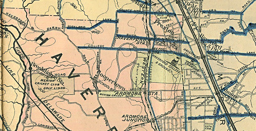
I don't know Jim, I don't recall it ever being mentioned here in previous discussions. The first mention I can find of "Golf House Road" is 1915, and I seem to recall some others back when saying that road was never built until 1913 or so.
There are several oddities about that map as David mentioned, and I'm really trying to determine if we can glean anything useful or revealing from it. For instance, I thought perhaps the plotting of the map possibly well preceded that 1913 date, back to the 1910 or 1911 discussion/debate we've been having here about the timing of the Francis Exchange. However, I was able to find the map David did and it also includes the land of the Merion West course which wasn't acquired until 1913 and didn't open until May 1914.
There are other strange anomalies, such as the Eaton property between the golf course and Ardmore Avenue (to the right of the 6th hole) showing as part of the golf course, but the 3 acres of railroad land does not.

It would be interesting to track the history of those roads in the development. On the map, the areas in BLUE are roads that have macadam and presumably all the rest are dirt tracks. Since this map was apparently drawn a few years after the Pugh & Hubbard November 1910 map I'm not really sure how to interpret it, honestly.
Did a dirt track road exist prior to the creation of the golf course and Haverford Road? What were the dimensions? Also, I recall this picture (showing the dirt road) being posted previously from the Sayers Scrapbook and seem to recall it was related to an Opening Day program but don't have the specifics on hand. Obviously by Opening Day it would look something different than what's relayed on this map. It's a head-scratcher, for certain.

One final point related to David's overlay is that it would be difficult to imagine a "like for like" acreage swap between the bulging land going west of the clubhouse as drawn to the triangle at the top. I'd estimate the difference in acreage in a final swap given those dimensions would be giving up about 3x as much acreage given up near the clubhouse as would be gained near the top.
That's especially difficult to reconcile with the fact that Hugh Wilson told P&O that Merion had purchased 117 acres in his February 1911 letter only to have the Thompson Resolution in April 1911 requring a swap of land and the additional purchase of 3 more acres, finalized by Merion buying 120.01 acres of HDC land in July 1911.
What do you think?