News:

Welcome to the Golf Club Atlas Discussion Group!

Each user is approved by the Golf Club Atlas editorial staff. For any new inquiries, please contact us.


MCirba

  • Karma: +0/-0
Re: Ron Whitten on Shinnecock
« Reply #350 on: July 06, 2015, 02:51:41 PM »
David,

Chill out.   I sincerely thanked you for taking the time to do that and you have to admit that it's an open question why they would create an artificial border where previously none existed at the north end of the Johnson Farm property given the quarry's location if that's your belief.

My west of the clubhouse line was meant to be humorous.   

Most importantly, I'm trying to understand how they secured 117 acres in November 1910, still had 117 acres in February 1911, and then needed three more of HDC land by July 1911. 

None of our theories effectively address that question and the math doesn't work in anything we've collectively conceived to date so I appreciate the ongoing discussion and attempts to figure this out.

**ADDED**  I'm definitely willing to consider that this map might be based on either an earlier HDC Land Plan crafted before November 15th, 1910 and may even be one that was crafted AFTER that November 1910 map with the Approximate Location of Road.

I say this because the April 19th 1911 MCC Minutes tell us that the Committee did numerous plans prior to their visit to NGLA so who among us can say what any of those plans looked like with any degree of certainty, or what portions of the Johnson Farmland they were located on?
« Last Edit: July 06, 2015, 02:59:18 PM by MCirba »
"Persistence and determination alone are omnipotent" - Calvin Coolidge

https://cobbscreek.org/

DMoriarty

  • Karma: +0/-0
Re: Ron Whitten on Shinnecock
« Reply #351 on: July 06, 2015, 03:08:06 PM »
This "artificial border" stuff is just plain nonsense.  HDC not only controlled the Johnson farm, they controlled everything west of it as well.  So whatever western "border" they created to set off the golf course would be "artificial."

Francis indicated that the location of the 15th green and 16th tee were not originally considered to be part of the golf course.  Jim, Bryan, and I believe him.  You don't.

Here are the western section of the Dallas estate and Johnson Farm properties, with the area containing the 15 green the 16th tee cut off.  Looks like a capital "L" sitting on its side.


« Last Edit: July 06, 2015, 03:19:43 PM by DMoriarty »
Golf history can be quite interesting if you just let your favorite legends go and allow the truth to take you where it will.
--Tom MacWood (1958-2012)

DMoriarty

  • Karma: +0/-0
Re: Ron Whitten on Shinnecock
« Reply #352 on: July 06, 2015, 03:19:13 PM »
As for the 117 vs. 120 acres. We don't know.  Your theory makes no sense for reasons I have repeatedly explained.  My guess is that HDC and Merion agreed to the location of the dividing road, agreed to the price for purchase of that land, built the road, then when they did the legal description for the deed it came out to 120.01 acres.

But, as I said above, all this comes down to one thing.  Francis told us that that the location of the 15th tee and 16th green were not originally part of the golf course land.  Some of us believe him.  You don't.
Golf history can be quite interesting if you just let your favorite legends go and allow the truth to take you where it will.
--Tom MacWood (1958-2012)

MCirba

  • Karma: +0/-0
Re: Ron Whitten on Shinnecock
« Reply #353 on: July 06, 2015, 03:45:31 PM »
David,

Sure, in theory they could have gone further west off the Johnson Farmland but my point about them creating an artificial boundary to the north of the former Johnson property is that it seems counter-intuitive to what they were told by Macdonald at the very top of his letter;

Mr. Whigham and I discussed the various merits of the land you propose buying, and we think it has some very desirable features.  The quarry and the brooks can be made much of. 

If Macdonald was told by Merion that the land they were considering stopped just past today's 17th green don't you think they might have suggested that Merion try to get additional land north of there?   It would seem fairly obvious in retrospect, especially if he was told that HDC controlled the whole shebang, aside from the Haverford College parcel.

I know what Jim believes but I'm not sure about Bryan who I suspect likes to shoot holes in both our theories and would possibly say he's looking for more information before making a determination, but I may be wrong.

I also wouldn't characterize my position as saying the land for the present 16th tee and 15 were always part of the golf course.   The most plausible explanation IMO based on all of the evidence is that much of the land of those two holes (and the #14 green) was too narrow for the holes they planned up in that neck of the course and Mr. Francis recalled the final dimension that were created, 130x190.

One reason I'm being a stickler for the math here is that we know they purchased more land they they originally secured.   If, for instance, that new map you produced indeed showed land they were working on prior to the Francis exchange, I don't understand how it could have been an even swap to trade the land not used west of the clubhouse for the parcel you indicated above the Haverford College southern boundary.   As I mentioned, I would think the size of the parcel across from the clubhouse that would need to be traded would have been roughly triple the size of the triangle they would have traded for.   What's your thoughts on that?
"Persistence and determination alone are omnipotent" - Calvin Coolidge

https://cobbscreek.org/

DMoriarty

  • Karma: +0/-0
Re: Ron Whitten on Shinnecock
« Reply #354 on: July 06, 2015, 05:20:00 PM »
You've distorted Francis's words beyond recognition.

As for what Bryan thinks, see his post 330.

As for what you think Macdonald should have said, it is all self-serving speculation on your part and adds nothing productive to the conversation.

As for the the 117 acres vs. 120,  I know what they said, but I've seen nothing other than the 1910 plan identifying the land they supposedly secured, and that plan has more than 117 acres included in the golf course.  In my opinion they thought they were purchasing the land equal to identified on that map, which is why the sent it to their members.  (This was your opinion too, before you knew it wasn't 117 acres.)

As for your theory about 3x the land, I don't know what you think you are looking at.  Look again at the image I just posted showing 120 acres.  Merion eventually purchased 120 acres.   So the net difference between what is shown and what they bought is zero.
« Last Edit: July 06, 2015, 05:23:38 PM by DMoriarty »
Golf history can be quite interesting if you just let your favorite legends go and allow the truth to take you where it will.
--Tom MacWood (1958-2012)

MCirba

  • Karma: +0/-0
Re: Ron Whitten on Shinnecock
« Reply #355 on: July 07, 2015, 09:58:43 AM »
David,
 
Please see my comments in blue below, thanks.
 
You've distorted Francis's words beyond recognition.
 
Where did I mis-quote Francis?   You think he meant that he acquired the entire 130x190 plot in the land exchange and I think he meant that's the dimension of what he ended up with after the exchange.   Whether the original pre-exchange dimension of the northern-most land of the Johnson Farm was 0x0 as you believe, or 100x260 as the November 15, 1910 Pugh & Hubbard scale map measures, or some other dimension mapped by Richard Francis after the Wilson Committee was formed indicating 117 acres that were secured, we know that the final dimension of that plot after the exchange was 130x190.   
 
We also know that Francis told us that they had already routed 13 holes prior to his brainstorm with the help of a little land north of Ardmore Avenue, which I hope we can agree was the leased Railroad Land.   We also know Francis told us that his brainstorm solved the problem of how to fit the last five holes.   We also know that within a day or two of his brainstorm they had workmen blasting away at the site of the 16th green so we can assume that they knew more or less where to place the last five holes prior to his brainstorm but didn't have enough room.   We also know that this plan was the one the Committee settled on after creating numerous plans on the new land prior to their visit to NGLA in March 1911 and re-arranging the course and creating five new plans (on paper) after returning from NGLA.   We also know that Francis told us that the land he exchanged across from the clubhouse did not fit in with "any golf layout" so we can reasonably assume that multiple plans were still under consideration at the time of his brainstorm.   We also know that Merion didn't own any of the land in question prior to December 1910 when HG Lloyd purchased the entire 140 acres of the Johnson Farm and the 21 acres of the Dallas Estate.   We also know that was because Mr. Cuyler, Merion's counsel, recommended in December 1910 that Lloyd do so because the boundaries of the golf course had not been determined at that juncture. 

We also know that Merion reported to their members in November 1910 that they had secured 117 acres from HDC for the golf course, after five months earlier in July 1910 having stated that they would need "about 120 acres" for golf (which with the addition of 3 acres of leased land would equal the desired 120 acres which eventually became 123 acres in total as the plan they approved required them to purchase 120 acres from HDC, not the 117 they originally secured).   

We also know that in February of 1911 Hugh Wilson wrote Piper & Oakley that the club had purchased 117 acres for the golf course and attached a contour map of the property, which was likely the work of Richard Francis.   They would have needed to know what the working boundaries of the property were by that time as they were working on various routings (at least one of which evidently didn't fit).   We also know that the Merion Cricket Club minutes of 4/19/2015 stated that the plan in question required them to exchange land already purchased for "adjoining" land plus the purchase of three additional acres.   We also know that the final purchase from HDC was not the 117 acres originally secured but instead 117 acres + 3 acres additional for 120.01 acres.   
 
Those are the facts.   For someone to believe that Francis had his brainstorm prior to November 15, 1910 based on him saying 40 years later that he exchanged land not used in any golf layout for land 130x190 up where the 15th green and 16th tee are located, and the fact that a portion of that land is partially identified in green next to an approximated drawing of a road on the November 15, 1910 Pugh & Hubbard map (which also includes land identified as golf course in that triangle that never became golf course land), a map you recently stated you believed that Pugh & Hubbard never even attempted to measure the golf course, then they would have to either ignore or explain away all of those facts that fly in the face of that contention.   To date, I've yet to hear a viable explanation from anyone reconciling all of the facts above with that November 1910 date for a finalized routing. That's why I was excited to see your new map, but that one has problems, as well, as I'll point out below.

 
As for what Bryan thinks, see his post 330.
 

I have great respect for both Bryan and Jim and give their positions serious credence.   In this case, I think they are missing the forest for the trees, however.   But, if we're looking to others for support of our position I'm happy to side with Jeff Brauer and others but I'd rather not get into that tit-for-tat.   Everyone here can speak for themselves on what they believe and no one is very shy on-line.   


As for what you think Macdonald should have said, it is all self-serving speculation on your part and adds nothing productive to the conversation.
 
I repeated exactly what Macdonald told them in his first paragraph, that the quarry and brooks could be made much of.   If you think he wouldn't have advised them to take as much land around the quarry as they could for flexibility, and instead wouldn't have noticed that the land they were considering acquiring painted them into a quarry bound corner when much more land was directly availble to them north of the quarry,  I think that gives us a very good idea how much actual routing CBM was actually doing for the Committee.

As for the the 117 acres vs. 120,  I know what they said, but I've seen nothing other than the 1910 plan identifying the land they supposedly secured, and that plan has more than 117 acres included in the golf course.  In my opinion they thought they were purchasing the land equal to identified on that map, which is why the sent it to their members.  (This was your opinion too, before you knew it wasn't 117 acres.)
 
David, respectfully, it sounds like you're trying to have it both ways.   The other day you told us that you don't think Pugh & Hubbard measured the golf course for that map and now you're saying that "they thought they were purchasing the land equal to identified on that map, which is why they sent it to their members."  If you thought that that map specifically identified the land they were acquiring for the golf course, at what point did you notice that the triangle on the northern part did not measure the 130x190 that Francis specified but instead measured something like 100x260, much narrower and much longer than the land they actually purchased?
 
As far as the 117 acres they secured, you know that figure was specified in every club document during the period from November 1910 into February 1911, all before needing to go to the Board of Governors to gain approval for the purchase of 3 additional acres in April 1911 in conjunction with the swapping of other land "already purchased" for other land.   In fact, this exchange and additional purchase is the only reason that the Golf Course plan with Macdonald's blessing had to go to the Merion Cricket Club Board of Governors for approval at all. 
 
We can pretend that they didn't secure 117 acres but that isn't consistent with the facts.   Instead, that November 1910 Pugh & Hubbard map with an "Approximate Location of Road" serving as the golf course boundary that actually measures about 124 acres, not 117 acres is simply consistent with the fledgling state of the planning effort at that point and is consistent with what Cuyler wrote in late December 1910 that the boundaries of the golf course had not yet been determined. 


As for your theory about 3x the land, I don't know what you think you are looking at.  Look again at the image I just posted showing 120 acres.  Merion eventually purchased 120 acres.   So the net difference between what is shown and what they bought is zero.

The Johnson Farm property was 140 acres and the western boundary could flex many more into other properties under HDC control.   Drawing 120 acres south of Haverford College is not a difficult exercise, but lets not forget that the 130x190 property you say they acquired in the Francis Exchanged measured 4.8 acres, so under your premise, any give across from the clubhouse had to measure exactly 4.8 acres, as well and it looks to me like you've got considerably in excess of that, no?


However, my initial comment about 3x the land referred to your overlay map.  If you think the new map you found is perhaps an earlier HDC Land Plan, then for your theory about an even swap to be real, the amount of land across from the clubhouse should equally match the land they would newly aquire up in the triangle.   Yet, compared to the as-built of the Atlas, the land across from the clubhouse fitting outside the final boundaries is considerably greater (I estimated 3x) than the land falling out in the triangle above.   For this map to support your theory, those acreages should be exact, correct?


***ADDED***
 
For discussion purposes, let's consider that November 15, 1910 Pugh & Hubbard map on it's face with the “Approximate Location of Road” as just that – it wasn’t accurate, because Merion simply didn’t know the exact 117 acres at that point or even over a month later according to Cuyler's letter.   
 
So, let’s roll with that.  You and Bryan claim it doesn't represent 117 acres, that it is more (124 acres) and we know it changed, with me and Brauer and others believing the road was simply re-aligned a bit.
 
However, the corollary is that it doesn’t mean anything, then why should it mean anything in particular, i.e., including that a land swap had taken place?  Most likely Pugh & Hubbard just drew a curving line that approximated the existing roads in the area, connecting with College Ave. on the north, right? 
 
Given those known inaccuracies and uncertainties, why is it logically ok to assume it meant the swap was in place?  Isn't that fallacious on its face given the dimensions of that land on the map doesn't equal the 130x190 that they ended  up with?


If a finalized routing was in place by November 15, 1910, wouldn't it logically follow that the map commissioned "For the Merion Cricket Club" would include a stick drawing, much like is seen on the Atlas above and/or at least the finally correct property line? 
 

« Last Edit: July 07, 2015, 01:04:39 PM by MCirba »
"Persistence and determination alone are omnipotent" - Calvin Coolidge

https://cobbscreek.org/

Jeff_Brauer

  • Karma: +0/-0
Re: Ron Whitten on Shinnecock
« Reply #356 on: July 07, 2015, 12:04:34 PM »
Mike,

I have always found this to be among the most compelling pieces of David’s position, and considered it carefully before making any conclusions.  As you allude, I have generally felt the road was merely re-aligned, probably after the NGLA meeting and before the April meeting, when they prepared five different plans. 

For the swap to be in place by November 15, 1910, we have to believe that November plan was a unique combination of being accurate in some specific ways and yet approximation of the land parcel under consideration in many other ways. It is a small chance, IMHO.

Besides, from memory, the following other positions need some explaining for a pre November routing to have taken place, and I don’t think satisfactory evidence best fits that timeline has ever been presented.  For instance, from memory, we also have to believe:

Francis was not only on the golf  committee but on the land search committee, but somehow,  never credited. (His remembrance only mentions he was on the golf committee, when he came up with the idea)

Or, the golf committee was started well  before the January date we assume.  Neither are in the record, and of course, David is against this, because it puts Wilson in the design again. 

We would also have to believe that the many plans they took to NGLA had a nearly final routing, and focused on tee, green and bunker design.  (Which, BTW, doesn’t seem impossible, because they said they were there to study feature designs of NGLA)  and the later 5 revisions were merely  feature designs, not routing plans.

Also, then CBM came to Merion in April were only to make recommendations on  bunkering, hole designs, etc.  But, the report said  ”lay them out”, which sounds like approval of routing more than bunkering, etc., but it is possible.

Lastly, we would have to believe that the quarry was still a working quarry in Nov. 1910, and that Merion had the right to go out and tell them where to blast for 16, even though they didn’t own the land. (Also possible, because I am not sure the Quarry would care where they got their few remaining stones/gravel) 

More importantly, if the swap was in November, and they told them to blast the 16th green, again, at least the 16th green location would have to be settled, when the rest of it wasn't (presuming the later many plans and five plans were routings) Also, but it seems from the story that it was the last thing settled.  It doesn’t seem to fit with being settled in November, but then consulting CBM and presenting the plans to the board in April, expanding the land to 120 in a board meeting in July, etc.

More importantly, we do know that is when the board made it official, upon seeing plans and recommendations from the committee.

Settling the land swap in April makes for a more  logical and linear sequence, which is more in line with that record, and also, how it actually goes in golf course design, even admitting that the process does go round and round to a certain degree, as well as back and forth.  But why select a hole concept or design bunkers until you know the hole will actually be there?

Also, if it was November, and Francis took the plans to Lloyd (which does make sense as land owner) he doesn’t think to mention CBM.  And, as David admits, there is really still nothing in the record saying CBM was involved in that period.  So, it doesn't support CBM as the "creative genius" behind the project, it seems to favor the committee doing the work by itself.

As you can tell, I went over this in my mind again, and do see the other side, but I don’t recall anyone offering up any rational timeline that fits those known records/facts/occurrences to prove a November routing, no matter what the map looks like on that day.  We agree its an approximation, so how can we be sure THAT part of it is accurate, in light of all the other things mentioned above?

I can't, but am happy to re-read it or other opinions to be convinced, as there is a bit of logic in there.


« Last Edit: July 07, 2015, 12:17:12 PM by Jeff_Brauer »
Jeff Brauer, ASGCA Director of Outreach

DMoriarty

  • Karma: +0/-0
Re: Ron Whitten on Shinnecock
« Reply #357 on: July 07, 2015, 12:49:07 PM »
So many blue words.  It says something about your position that you have to keep typing so many words to try and explain away so few.

1. You are distorting Francis beyond recognition. Francis described the land involved in the exchange as follows:  "The land now covered by fine homes along Golf House road was exchanged for land about 130 yds. wide by 190 yds. long - the present location of the 15th green and 16th tee." 

You've distorted this so that in your version the swap really wasn't about the approx. 130x190 yd. location of "the 15th green and 16th tee" but rather was about a long, thin sliver of land hugging the current location of the road. That is NOT what Francis wrote.   In your version, the 16th tee and 15th green were not even involved in the swap.  That is absurd.

2. You repeatedly and purposefully distort my position by falsely claiming that I believe that there was a "finalized" plan in place by  November 1910.   This is not my position. My position is that the plan wouldn't be "finalized" until CBM returned to Merion and approved the final plan many months later.

3.  Your continued speculation about what you think CBM should or should not have told them provides a good example of the type of fallacious logic which pervades so much of what you write.  You make up fake conditions (CBM should have told them to acquire as much land around the quarry as the could for flexibility), draw fake assumptions about the evidence (CBM must not have told them this), and then draw fake conclusions (this tells us something about the level of CBM's involvement).  The record supports none of this!  Once again, you are just making shit up. 

4.  You are (again) misrepresenting my position regarding the 1910 map.  There is a difference between identifying land to be purchased and exactly measuring that parcel in acres.  For example, to identify the parcel, the parties could have staked out, drawn out, or even built the road, while agreeing that everything on one side would go to MCC. That would not necessitate determining the exact measurement of the area in question until the deed was drawn up. No doubt Merion thought the land they would eventually secure for $85,000 measured 117 acres . Turned out got 120 acres for their $85,000. Lucky for them, but that they got what they bargained for is evidenced by the price they paid.

5.  As for your speculation about the Good Roads map, you are making so many unsupportable assumptions that I cannot really keep up.  In response to your request, I provided you with an image of what 120 acres would look like with the property approximately shaped like the road on the Good Roads map.  On the image I showed you, the parcels inside and outside the current course net to zero.  Simple as that.   
« Last Edit: July 07, 2015, 01:20:01 PM by DMoriarty »
Golf history can be quite interesting if you just let your favorite legends go and allow the truth to take you where it will.
--Tom MacWood (1958-2012)

Bryan Izatt

  • Karma: +0/-0
Re: Ron Whitten on Shinnecock
« Reply #358 on: July 07, 2015, 01:48:58 PM »

Mike,

I don't have time to go at all the points you're trying to make, but re the following statement,


Isn't that fallacious on its face given the dimensions of that land on the map doesn't equal the 130x190 that they ended  up with?
Quote


I still suspect/guess that Francis was describing a rectangle and not a triangle.  At some point prior to November 15 HDC and Merion agreed that the golf course was going to be bounded on the western side by a road - no doubt to aid in selling estate lots on that road overlooking the golf course.  Somebody told Pugh and Hubbard approximately where the road was to go before November 15th.

[/size]In the end, Merion did not end up with 130 yards by 190 yards up there, as you state above.  They ended up with an odd shaped piece that was about 115 yards wide on the southern end, about 327 yards up the eastern edge, 4 yards wide at College Avenue, and a curvlinear length I can't be bothered measuring along the western boundary along the Golf House Road.
[/size]
[/size]Golf House Road was built, in it's current location by July 1911 as described in the deed.  How long do you suppose it took to build a road in 1911.  Could they have done it between April 19th and July, 1911?
[/size]
[/size]   
[/size]

MCirba

  • Karma: +0/-0
Re: Ron Whitten on Shinnecock
« Reply #359 on: July 07, 2015, 02:19:57 PM »
Bryan,

I'm sure that I don't understand your evolved position but I'm eager to hear more as time permits.   

Perhaps it might help me conceptualize what you're saying if you break it down in terms of what (if anything) existed north of Haverford College southern boundary and after the Francis Exchange.   

Also, when you say they ended up with about 115 yards on the southern end, how are you measuring that?

Thanks.

David,

Do you believe that the course routing was complete once Francis had his brainstorm?   If his brainstorm was before that November 15, 1910 Land Plan was created, as you contend, what more needed to be done as far as routing the course after he made room for 15 and 16 and created the site for the 16th green a day or two after the brainstorm?   After all, the first 13 holes had already been routed prior to then and they clearly knew where they wanted 15 and 16 to go.

Thanks.
« Last Edit: July 07, 2015, 02:30:10 PM by MCirba »
"Persistence and determination alone are omnipotent" - Calvin Coolidge

https://cobbscreek.org/

MCirba

  • Karma: +0/-0
Re: Ron Whitten on Shinnecock
« Reply #360 on: July 07, 2015, 02:43:11 PM »
David,

Yes, I'm making stuff up in assuming that CB Macdonald would have advised the Merion Committee during his June 1910 visit to get as much land around the quarry as possible so that they could use it for golf holes.   The fact that he recognized its potential, even mentioning it first and foremost in his letter to Merion after his June 1910 site visit suggests to me that the only way to utilize that potential was to acquire surrounding land that could be used for golf.

One thing that I don't recall ever being mentioned here before is the simple fact that from a golf standpoint, the quarry could only be reasonably approached from one direction, the north.   If approached from the south, or west, it would be like playing off a cliff so dramatic is the fall and played from the east is impossible because the quarry extends to that eastern boundary.

So, there really is only one place the 16th hole could have realistically been approached from.   I think Macdonald and anyone else out on that property for 30 seconds or more would have instinctively recognized this.

So yes, in my flight of fancy I'd imagine the following conversation;

CBM: (standing at the site of today's 17th green) Aye, laddies...this quarry is quite dramatic.   Much can be made of it for golf purposes.

Merion: Oh wow...and here we thought we might have to fill the whole thing up, Charlie.   Thanks for the idea.

CBM: I'm assuming ye lads are bright enough bulbs to insist that the Developers give you the surrounding available land which stretches several hundred yards north of here, yes?

Merion:  (looking at each other nervously)  Well, actually, we thought that particular land would make for some nice quarry-side housing units.

CBM:  What?@?!@

Merion: (embarrassed) Yes, in fact, don't back up or you'll be trespassing.

CBM: Egads, you dunderheads!!...how in Hades did you all get your Ivy League degrees??   


« Last Edit: July 07, 2015, 02:49:37 PM by MCirba »
"Persistence and determination alone are omnipotent" - Calvin Coolidge

https://cobbscreek.org/

DMoriarty

  • Karma: +0/-0
Re: Ron Whitten on Shinnecock
« Reply #361 on: July 07, 2015, 02:46:59 PM »
Mike,  Looking at his old posts, I think that has been Bryan's position all along.

Francis described an area "about" 130x190 yards, the location of the 15th tee and 16th green.  This roughly, but not exactly, describes the area between the Haverford College property and the road.   A 130x190 yd. rectangle is 5.1 acres.  So Merion swapped about 5 acres of land next to the Haverford College property for "land now covered by fine homes along Golf House road."

The white rectangle below is 130x190 yards and measures 5.1 acres.  The orange rectangle also measures 5.1 acres.  I am not suggesting that these represented exactly what was swapped because obviously they do not.  But I do think they give a rough idea of the swap that Francis was describing. 
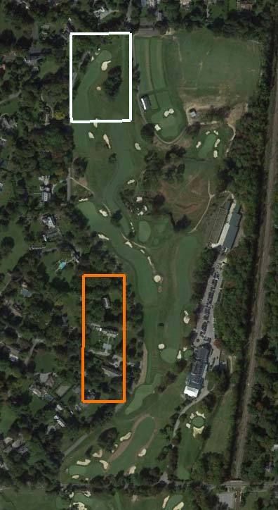


Apparently, prior to the swap, Merion was trying to fit the golf course on land which excluded the white triangle from consideration.  The swap allowed them to use the area in the white triangle, and thus resolved a routing problem, but they gave up land across what is now Golf House road to get access to the land in the white triangle.  I don't think it is any more complicated than that.
__________________________________

Also Mike, thanks for further demonstrating the extent of your reasoning powers in that last little flight of fancy. It is too idiotic to take seriously, and this includes your strange conjecture that the quarry could only be approached from the north. So much for the 17th hole!
« Last Edit: July 07, 2015, 02:49:25 PM by DMoriarty »
Golf history can be quite interesting if you just let your favorite legends go and allow the truth to take you where it will.
--Tom MacWood (1958-2012)

DMoriarty

  • Karma: +0/-0
Re: Ron Whitten on Shinnecock
« Reply #362 on: July 07, 2015, 03:05:32 PM »

You keep substantively changing your previous posts, so it is a bit hard to keep up.  You added the following question to one of your posts above:
Do you believe that the course routing was complete once Francis had his brainstorm?   If his brainstorm was before that November 15, 1910 Land Plan was created, as you contend, what more needed to be done as far as routing the course after he made room for 15 and 16 and created the site for the 16th green a day or two after the brainstorm?   After all, the first 13 holes had already been routed prior to then and they clearly knew where they wanted 15 and 16 to go.

As for fitting the first 13 holes, back in June of 1910 CBM had suggested that they add the land which made this possible. Thus Francis's description of fitting the 13 holes"with the help of a little ground on the north side of Ardmore Avenue."

I think the Francis modification was most likely one of the "many different courses" which had been laid out on the land prior to Wilson's visit to NGLA, and it sounds like the one CBM ultimately approved. Another would have been whatever they were trying to do before the swap, which may have been suggested by CBM.  Barker's plan was another.
Golf history can be quite interesting if you just let your favorite legends go and allow the truth to take you where it will.
--Tom MacWood (1958-2012)

Jeff_Brauer

  • Karma: +0/-0
Re: Ron Whitten on Shinnecock
« Reply #363 on: July 07, 2015, 04:09:26 PM »
Mike,

I understand your quarry point, and that to use it twice for anything other than a tee fronting hazard, it would need multiple approaches.  As an architect, I really think in broader terms early in the routing, I.e., is there enough space to fit 18 holes?  CBM hints at the same, and the logic of what David is saying is that prudent men, given a minimum of acreage, would probably do a test routing before the purchase. It doesn't always happen, and they may have felt comfortable knowing the parties would give them some wiggle room.

That said, I always got the impression that in June, something in the Barker routing showed them they needed more room south of Ardmore in the form of the Dallas Estate.  Basically, the land was 4 holes wide in rectangular form.  To get 12 holes, it would need to be 3 holes long, using an average hole length of about 350 yards, just to have a chance to fit the required holes in, even without considering topography.

It doesn't take us long, looking at the finished product, to realize that they needed to get 7 holes in, and needed 2 wide by almost 4 long, or 4 wide at two long.  The final routing is a combo of both.  Even a quick look probably would show they needed that property up to College to have a chance.  The question is when.

Other than the inconsistencies noted from the record, and one more I forgot to mention last time - it appears the topo map was commissioned and arrived about Feb. 1, 1911.  I wonder if they could/would route without one?  CBM seemed to think topo info was necessary, both in his letter and in how he worked at NGLA.  I assume they followed his advice. 

And, given the secrecy they worked under in buying the land, I am pretty sure no survey crew was sent out as a visible sign they were interested, until the Dallas Estate land was at least under option, if not fully under contract.  Was that August, or October?

Like I say, the theory of a rough test routing, is possible. In my world, it does happen, maybe 25% of the time, and in other cases, the owner just presents us with property - for better or worse.  It would have made sense, including identifying the "triangle" in rough shape, but did it happen, given the other points of the historic record?
Jeff Brauer, ASGCA Director of Outreach

Jeff_Brauer

  • Karma: +0/-0
Re: Ron Whitten on Shinnecock
« Reply #364 on: July 07, 2015, 04:13:34 PM »

As for fitting the first 13 holes, back in June of 1910 CBM had suggested that they add the land which made this possible . Thus Francis's description of fitting the 13 holes"with the help of a little ground on the north side of Ardmore Avenue."

I think the Francis modification was most likely one of the "many different courses" which had been laid out on the land prior to Wilson's visit to NGLA, and it sounds like the one CBM ultimately approved. Another would have been whatever they were trying to do before the swap, which may have been suggested by CBM.  Barker's plan was another.

Agree with this being possible, but then I still think we have to discount the blasting for the 16th hole soon thereafter.  If it was still an active quarry, then it might be possible as there would be no cost to MCC.  If it had gone dormant, then MCC wouldn't have gone to the expense to blast on their $40K construction budget unless they were sure of that hole location. Either way, if the routing wasn't firm, blasting makes little sense as the topo might be used differently for another hole design.
Jeff Brauer, ASGCA Director of Outreach

DMoriarty

  • Karma: +0/-0
Re: Ron Whitten on Shinnecock
« Reply #365 on: July 07, 2015, 04:46:14 PM »
Jeff Brauer wrote above that it appears that the contour map was commissioned and arrived about Feb. 1, 1911. While Wilson wrote of sending a contour map to Piper/Oakley on February 1, there is nothing in the record indicating when Merion first obtained the contour map.

Further, whatever Brauer's experiences with developers who locked themselves into land before considering whether a course would fit, this does not seem to have been the case with Merion.  Otherwise, why trouble CBM and HJW to come to Philadelphia to determine whether 18 first class holes could fit on the property they were considering?  And why leave the road border flexible?  The very existence of the Francis swap indicates that they figured out the routing before setting the boundaries, otherwise there would have had to have been an actual legal exchange of property.
Golf history can be quite interesting if you just let your favorite legends go and allow the truth to take you where it will.
--Tom MacWood (1958-2012)

Jeff_Brauer

  • Karma: +0/-0
Re: Ron Whitten on Shinnecock
« Reply #366 on: July 08, 2015, 09:49:33 AM »
David's post highlights some obvious things:

Maybe I don't know when the topo maps arrived, and just assume it was sometime near when it shows up in the record.  (And why not, they commissioned it, they needed it for planning, and why would they sit on it until February?)

Of course, neither does David, but it hasn't stopped him from assuming it arrived earlier, was used by CBM, etc., etc. etc.  His non answer is also typical and illustrative of his argumentative style, but don't bolster his assumptions at all.  There are some inconsistencies in the record that should ideally be resolved to be sure of any theory, which he expertly ignores for the past 7 years.   

Lastly, as to his contention that

"Further, whatever Brauer's experiences with developers who locked themselves into land before considering whether a course would fit, this does not seem to have been the case with Merion.  Otherwise, why trouble CBM and HJW to come to Philadelphia to determine whether 18 first class holes could fit on the property they were considering?  And why leave the road border flexible? "

They asked CBM to the site one day, as a counter point to HDC's bringing Barker in. They wanted their own expert to assist in forming the development.  In my post no. 276 I outlined many assumptions David made without support in his original essay, including the fact that David has assumed that CBM told Merion to do things as he did.

Think about it.  Offer to buy 120 acres from a developer in an area planned for active development, without a routing plan in place?  Sounds more like CBM's first option at NGLA, not his ideal one.  And, there is no hint in CBM's follow up letter that they should follow his second NGLA attempt, it only notes that their problem would be to fit 18 first class holes in the property available.   He knew the score at Merion, and Merion wasn't NGLA, so he advised accordingly. 

And, the fact is, 99% of golf courses buy the land, route the course, figure out the features and then build the course.  The Merion record shows June-Dec. 1910 focused on the purchase of the land, Jan-April 1911 focused on the design of the golf course, with construction activity after that.  Nothing in their record suggests this was that far out of the ordinary process, including anything CBM wrote.

That is what they say in their own words, and the record says. To extrapolate any further is a stretch of the record.  If David thinks differently maybe he will answer some of our questions, with some real facts in the record to support it, rather than his tired assumptions.
Jeff Brauer, ASGCA Director of Outreach

MCirba

  • Karma: +0/-0
Re: Ron Whitten on Shinnecock
« Reply #367 on: July 08, 2015, 10:16:54 AM »
Jeff Brauer wrote above that it appears that the contour map was commissioned and arrived about Feb. 1, 1911. While Wilson wrote of sending a contour map to Piper/Oakley on February 1, there is nothing in the record indicating when Merion first obtained the contour map.

Further, whatever Brauer's experiences with developers who locked themselves into land before considering whether a course would fit, this does not seem to have been the case with Merion.  Otherwise, why trouble CBM and HJW to come to Philadelphia to determine whether 18 first class holes could fit on the property they were considering?  And why leave the road border flexible?  The very existence of the Francis swap indicates that they figured out the routing before setting the boundaries, otherwise there would have had to have been an actual legal exchange of property.

David,

The question of the when that contour map was created is an interesting one.   Considering that CBM caveat-ed his comments to Merion in his July 1st, 1910 letter that he couldn't be certain whether they could fit 18 good holes in the space they were considering without a contour map, I always found it odd that the next map mentioned in any of the Merion correspondence was the Pugh & Hubbard November 15, 1910 map that didn't include contours.   All we know for a fact is that they had one by February 1st, 1911, when Hugh Wilson offered to send one to Piper & Oakley.   It's very likely that the contour map in question was created by Richard Francis after he was added to the Merion Committee in January 1911.   

Jeff Silverman's Merion history book mentions that Wilson's Committee was formed on January 11, 1911, so that would have given Francis about 20 days to create a contour map which seems reasonable to me.

You're also correct that Merion didn't lock themselves into a property before routing the golf course, at least not in the way we would think of it today.   H.G. Lloyd and his deep pockets was the reason for that.

From a timeline perspective;

  • June 1910 - Rodman Griscom asks his friends Macdonald and Whigham to visit a site in Ardmore that Merion is considering for their new golf course and they follow with a letter that is a somewhat lukewarm endorsement that expresses concerns about the total acreage and suggests they could possibly do it by acquring a bit more land near the clubhouse
  • July 1910 - Merion's search committee sends an internal letter mentioning that HDC is willing to sell them "100 acres or whatever would be needed" for their golf course.   The letter states that they would likely need 120 acres.
  • October/Nov 1910 - HDC acquires the 21 acre Dallas Estate
  • November 10, 1910 - Connell of HDC sends Allen Evans of Merion a letter indicating that he's been talking with Lloyd and offers 117 acres to Merion
  • November 10, 1910 - Evans responds to Connell that he's interested in buying 117 acres but asks that Connell give Merion a little time to put together a corporation that would do the deal and lease the course to the Merion Cricket Club.
  • November 15, 1910 - Evans/Merion sends a letter to its members describing the opportunity to purchase 117 acres that includes a freshly drawn map from Pugh & Hubbard done "for Merion Cricket Club" that the accompanying letter states shows the 117 acres the club has secured.   The boundary between golf course and the adjacent real estate is shown by a proposed road connecting the existing Ardmore Avenue and the paved College Avenue and whose location is "approximate"d.   The drawing shows no golf holes and modern technology shows the area indicated for the golf course was probably closer to 124 acres.
  • December 10, 1910 - H.G. Lloyd, acting on advice of Merion's counsel, because the boundaries for the golf course have not yet been determined, purchases the entire 140 acres of the former Johnson Farm and the 21 acres of the former Dallas Estate from HDC, effectively putting that land under Merion's control but also having fiduciary responsibility to HDC as an officer of that organization.   Of that, Merion is still operating under the assumption that they'll build their course on 117 of those acres.   
  • December 21, 1910 - Cuyler, in letter form to Allen Evans, describes what he has advised Lloyd to purchase, which was a done deal at that point.   The letter, in part read; In regard to the title of the property the boundaries of the land to be acquired being as yet uncertain owing to the fact that the golf course has not been definitely located, it was found advisable that the Haverford Development Company should take the title in Mr. Lloyd‘s name, so that the lines could be revised subsequently. I would thank you to let me know as soon as the boundaries have been determined upon.
  • January 11, 1911 - Merion forms the committee charged with laying out and building their new golf course
  • February 1, 1911 - Hugh Wilson, writing for the Committee and on the advice of CB Macdonald contacts Piper & Oakley seeking agronomic advice.   He tells them that Merion has purchased "117 acres".
  • March 1911 - Merion's Committee visits NGLA and stays overnight.   Descriptions of the activities from both Wilson and the MCC Minutes indicate the first night spent going over the principles of the famous holes from abroad and the next day seeing Macdonald's versions of those holes and concepts through a tour of the NGLA course.   A letter to Piper & Oakley also mentioned some pamphlets Macdonald provided related to seed companies.
  • April 1911 - CB Macdonald comes back to Merion 10 months after his initial visit for his second and final time.   During his visit he looks over the land and helps Merion by selecting one of the Committee's final 5 plans.
  • April 19 1911 - At a Board of Governors meeting, the proposed plan is presented but asked for Board action because the plan that had Macdonald's blessing required an additional purchase and a land exchange from Lloyd acting for HDC.    The meeting minutes read in part, ; In order to accomplish this, it will be necessary to acquire 3 acres additional.   On motion of Mr. Thompson, the following was resolved;  Whereas the Golf Committee presented a plan showing a proposed layout of the new Golf Ground which necessitated the exchange of a portion of land already purchased for other land adjoining and the purchase of about three acres additional to cost about $7500.00, and asked the approval of this Board, it was on motion Resolved, that this Board approve of the purchase and exchange, and agree to pay as part of the rental the interest on the additional purchase.
  • July 1911 - Merion purchases 120.01 acres from HDC.   With the inclusion of the lease of 3 acres of railroad land which we know from Francis happened sometime prior to his brainstorm, the new Merion course would require a total of 123 acres.
« Last Edit: July 08, 2015, 10:23:53 AM by MCirba »
"Persistence and determination alone are omnipotent" - Calvin Coolidge

https://cobbscreek.org/

MCirba

  • Karma: +0/-0
Re: Ron Whitten on Shinnecock
« Reply #368 on: July 08, 2015, 11:06:38 AM »
Mike,  Looking at his old posts, I think that has been Bryan's position all along.

Francis described an area "about" 130x190 yards, the location of the 15th tee and 16th green.  This roughly, but not exactly, describes the area between the Haverford College property and the road.   A 130x190 yd. rectangle is 5.1 acres.  So Merion swapped about 5 acres of land next to the Haverford College property for "land now covered by fine homes along Golf House road."

The white rectangle below is 130x190 yards and measures 5.1 acres.  The orange rectangle also measures 5.1 acres.  I am not suggesting that these represented exactly what was swapped because obviously they do not.  But I do think they give a rough idea of the swap that Francis was describing. 


Apparently, prior to the swap, Merion was trying to fit the golf course on land which excluded the white triangle from consideration.  The swap allowed them to use the area in the white triangle, and thus resolved a routing problem, but they gave up land across what is now Golf House road to get access to the land in the white triangle.  I don't think it is any more complicated than that.
__________________________________

Also Mike, thanks for further demonstrating the extent of your reasoning powers in that last little flight of fancy. It is too idiotic to take seriously, and this includes your strange conjecture that the quarry could only be approached from the north. So much for the 17th hole!

David,

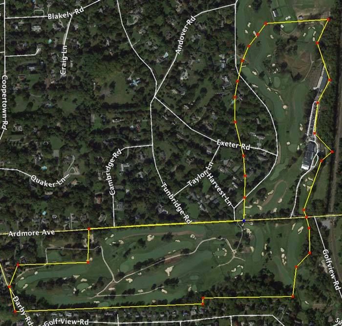
If that's Bryan's theory then I'm really not sure how it makes more sense to include a 5.1 acre rectangle than a 4.8 acre semi-triangle which is what's there in actuality?

Your drawing indicates much of that rectangle crossing the boundary across Golf House Road into the neighboring estates.   "Most", or "close" only counts in horse shoes, not real estate transactions.

Regarding my "idiotic" contention that the quarry could only be reasonably approached from the north, of course one could stand on the edge of the quarry cliff and play down into it on a par three as they do on 17 today.   That's hardly "approaching" the quarry but instead standing atop the ledge.

But instead of me responding to your continual and ineffectual insults, I'm feeling like I'm again channeling the original Committee participants...aaarrgggghhh...

Mr. Francis:  Mr Lloyd, we have a problem.

Mr Lloyd:  And what would that be my dear Mr. Francis?

Mr. Francis: You know that land that Mr. Macdonald told you and Mr. Griscom would be suitable for 18 good holes?   Well, I've been pouring over maps and...well...you know how he told you that the quarry can be made much of?   Well, I've been trying to make much of it and not much is happening but I'll keep trying much more.

Mr. Lloyd: For heaven's sake man, calm down...what do you mean?

Mr. Francis:  Well, for starter's the quarry is fricking HUGE!   I mean, it's 250 yards wide and 150 yards long!   And it's deep with a steep cliff wall on two sides so I can't come at it from the west or the south.   And the east side is more land owned by the railroad and we really don't want to deal with those bastards again right?

Mr. Lloyd: I won't have you using that type of profanity in my house.   Why some of those railroad robber baron...er...railroad officials are among the finest upstanding citizens of this community.   And afterall, they did help you locate those first 13 holes by leasing us those 3 acres if you recall.

Mr. Francis: (frustrated) I know, I know...I'm sorry.

Mr. Lloyd:  Tut tut, there now my good man.

Mr. Francis:  Ok, so back to the problem.   Our problem.   We've got those 13 holes and then we go north with 14.   I'm envisioning a big, uphill, challenging par four that will set the stage for an amazing finish.   And then...

Mr. Lloyd:  And then??

Mr. Francis:  Nothing.   

Mr. Lloyd:  Nothing?

Mr. Francis:   Nope.   Nothing but quarry.   Oh, you guys left me 150 yards to the left of it and a hefty 80 yards beyond it...thanks for nothing!

Mr. Lloyd:   But surely that young whippersnapper Mr. Wilson can help solve this problem?

Mr. Francis:  Who?   That guy?   Is he still a member?   Oh, that's right....But he won't even be appointed to head a Committee for months yet, and he's a Princeton fellow don't you know, so I have my doubts.

Mr. Lloyd:   True Dat.

Mr. Francis:  So here's what I'm thinking.   We get the 14th green up near that quarry wall and then for the next hole we can stand right on the edge and play to a par three on the quarry floor below.   But then how do we get down there?

Mr. Lloyd:  I'll have my workmen build a large spiral staircase down into the depths!   Problem solved!

Mr. Francis:   Ok, now we're cooking with kerosene!   Then, we need to get out so I'm thinking another par three in the opposite direction to the top of the quarry cliff wall for 16.   Kinda blind, but we can call it an Alps or something that will keep Macdonald happy.

Mr. Lloyd: Will that require an additional staircase?

Mr. Francis:  Perhaps.   But I still have two holes left.   Would it be considered gauche by future GCA afficianados to have three par threes in a row?   

Mr. Lloyd:  Some of them might think it's cool because it breaks the rules.   I can see that Naccarato guy asking for the distance to the quarry wall, just to watch his tee ball deflect back at him at 200 mph!  ;)

Mr. Francis:  Ok, then we go with the three par threes in a row.   That will make Mr. Macdonald pleased i'd imagine as we would be certainly making much of the quarry!   But then...

Mr. Lloyd:  Spit it out Francis!

Mr. Francis: But then we still need to get back to the clubhouse and my 17th hole ends down in the depths of the quarry.   Do you think Mrs. Biddle and the other members will like to finish with a 200 yard carry out of the quarry and a long downhill run to the green?

Mr. Lloyd:  Probably not, but too many members are taking up the game anyways.   That finish you describe ought to discourage a good number of them!

Mr. Francis:  Yes sir..    I knew we could solve this problem.   By the way, how did Wilson get that plum future committee assignment?   We do all the work and I just have this sinking feeling that history is going to give him all the credit.   

Mr. Lloyd:  He has pictures.   
« Last Edit: July 08, 2015, 11:15:55 AM by MCirba »
"Persistence and determination alone are omnipotent" - Calvin Coolidge

https://cobbscreek.org/

DMoriarty

  • Karma: +0/-0
Re: Ron Whitten on Shinnecock
« Reply #369 on: July 08, 2015, 11:58:19 AM »
 Your last post is apt. Your analysis has always been more about fantasy than reality. The same applies to many of the items in your timeline.
Golf history can be quite interesting if you just let your favorite legends go and allow the truth to take you where it will.
--Tom MacWood (1958-2012)