News:

This discussion group is best enjoyed using Google Chrome, Firefox or Safari.


MCirba

  • Karma: +0/-0
Re: Was C.B. Macdonald's routing of NGLA
« Reply #1275 on: June 06, 2015, 11:18:23 AM »
Sven,

That's a good point but it also suggests that planning for the Inn, both in terms of location and size, happened independent of Macdonald and his eventual plans to locate his course there and deciding to use that as his clubhouse.

Would you agree that it reads as if they would have made it larger (it was only 30 rooms to accommodate Shinnecock and National members as well as motorists) if they had known Macdonald ' s intent before planning/building?
"Persistence and determination alone are omnipotent" - Calvin Coolidge

https://cobbscreek.org/

MCirba

  • Karma: +0/-0
Re: Was C.B. Macdonald's routing of NGLA
« Reply #1276 on: June 06, 2015, 11:20:00 AM »
Mike,  The Shinnecock Inn did not open until the 1907 season.

Agreed David but it was already planned and was being built when Macdonald was quoted in Dec 1906.  Here again Macdonald was talking about accessibility to his course and says the Shinnecock Inn is being built.

« Last Edit: June 06, 2015, 11:32:50 AM by MCirba »
"Persistence and determination alone are omnipotent" - Calvin Coolidge

https://cobbscreek.org/

DMoriarty

  • Karma: +0/-0
Re: Was C.B. Macdonald's routing of NGLA
« Reply #1277 on: June 06, 2015, 11:30:28 AM »
They planned to build an Inn at least. But it is a bit much for you to pretend that CBM would definitely have calculated an exact yardage between his planned 18th green and the planned site for the Inn (if he even knew the exact site.)

Speaking of yardage calculations, if the planning had not yet begun in earnest then how was CBM able to describe the Cape in the detail provided?
« Last Edit: June 06, 2015, 11:32:42 AM by DMoriarty »
Golf history can be quite interesting if you just let your favorite legends go and allow the truth to take you where it will.
--Tom MacWood (1958-2012)

MCirba

  • Karma: +0/-0
Re: Was C.B. Macdonald's routing of NGLA
« Reply #1278 on: June 06, 2015, 11:36:01 AM »
David,

No question that he found the Cape hole before securing the land as well as the Alps, redan, and Eden.  I'm quite sure he had it measured somehow to determine if the direct carry was achievable.  

I wish we could have seen the original.  Today's hole is great but the original greensite looked to be amazing.
"Persistence and determination alone are omnipotent" - Calvin Coolidge

https://cobbscreek.org/

DMoriarty

  • Karma: +0/-0
Re: Was C.B. Macdonald's routing of NGLA
« Reply #1279 on: June 06, 2015, 11:41:01 AM »
So then you acknowledge that they weren't just riding the land to get an idea of the soil and undulations, but rather they were out there measuring key features and placing golf holes?
« Last Edit: June 06, 2015, 11:44:30 AM by DMoriarty »
Golf history can be quite interesting if you just let your favorite legends go and allow the truth to take you where it will.
--Tom MacWood (1958-2012)

MCirba

  • Karma: +0/-0
Re: Was C.B. Macdonald's routing of NGLA
« Reply #1280 on: June 06, 2015, 02:06:26 PM »
David,

We know by the time he secured the land he had found the sites for the Alps jlhill 15 feet higher than the one at Prestwick, turned and saw an ideal plateau for a redan, and also identified a site for an Eden green that would require an aerial approach over water that he thought an improvement over the original but that took him into a nook of the property he'd have to consider how to get out of.  Thus, the Cape was born.
"Persistence and determination alone are omnipotent" - Calvin Coolidge

https://cobbscreek.org/

DMoriarty

  • Karma: +0/-0
Re: Was C.B. Macdonald's routing of NGLA
« Reply #1281 on: June 06, 2015, 02:40:34 PM »
Nice job trying to avoid my question Mike.  As you just said, you are quite sure he had already measured the carry for the Cape.  And this was on a hole that, as depicted on the blueprint, was mostly under water.  He was already routing and planning and even measuring the course.

You can't pretend that, just because his "for instance" only included four famous holes, that these are the only holes he had yet considered.
Golf history can be quite interesting if you just let your favorite legends go and allow the truth to take you where it will.
--Tom MacWood (1958-2012)

Steve Lang

  • Karma: +0/-0
Re: Was C.B. Macdonald's routing of NGLA
« Reply #1282 on: June 06, 2015, 05:07:56 PM »
 8) Resurfacing after a week back at work, I was wondering:

1) Does anyone know when a "stymie gauge," as shown on the NGLA scorecard, was brought into/out of use?


and whether we perhaps need a modern equivalent for discussion threads?

Never mind, I just found this on golfclubatlas.com... pretty good reading on the site.

https://www.google.com/url?sa=t&rct=j&q=&esrc=s&source=web&cd=2&ved=0CCEQFjAB&url=http%3A%2F%2Fgolfclubatlas.com%2Fforum%2Findex.php%3Ftopic%3D1326.0%3Bwap2&ei=aGRzVeHmNMjWsAXK34GADw&usg=AFQjCNGYGMOjJcl49cutYZ1_wEjUMlrjnw&sig2=PYIXa0MkFPRwDtNs_Fzqiw&bvm=bv.95039771,d.b2w

2) Does anyone know where CBM & JW rented their ponies from, where were the stables, SE on White's Lane or more to the south?  I've seen where CB's later stables were on his 200 acre Ballyshear property.  Regardless, the paths and first views into the future NGLA property would or could have first been related to crossing the creek and second to following the unimproved road path(s) leading up the eastern flank on Bull Head Bay and into the property from low ground.  First impressions are hard to shake..

It appears there were some very adventurous horses in Suffolk Co. a 100 years ago ;D  Gotta love the poetic license in embellishing the diving horse, eh?


3) Does anyone have a delineation or measured where the oft quoted SH&PB Realty Co.'s available "450 acres" were on the Sebonak Neck?

Its clear their Olmsted and Vaux survey plat for Shinnecok Hills development didn't include survey of the meadows off of the Cold Spring Pond shoreline, as Redfield had lost his trespass court case against the Aldrich's, though the O&V plat drawing shows some NGLA boundary lines.

Is it possible that SHPB Realty really didn't have clear rights to the S-Neck area at the time of the options/sale to CBM?  Was this some classic leverage at play by CBM, perhaps from the survey(s) by Raynor or the other surveyor(s)?

The county records do show later separate sale(s) of property to what became the Sabin Bayberry Land estate.  Who was Corrigan, need to check. Per HISTORIC AMERICAN BUILDINGS SURVEY, BAYBERRY LAND (Bayberry Rest Home), HABS No. NY-6388

1.   1916a  Sale of property by Shinnecock Hills & Peconic Bay Realty Company to Sebonac Neck Land Company, Inc. 30 October, Liber 938:538. Suffolk County Deed Records, Office of the Suffolk County Clerk, Riverhead, NY.
2.   1916b  Sal of property by Edward J. Corrigan and wife to Sebonac Neck Land Company, Inc. 15 November, Liber 1001:26. Suffolk County Deed Records, Office of the Suffolk County Clerk, Riverhead, NY.
3.   1917  Sale of property by Edward J. Corrigan and wife to Sebonac Neck Land Company, Inc. 10 March, Liber 1001:63. Suffolk County Deed Records, Office of the Suffolk County Clerk, Riverhead, NY.
4.   1918  Sale of property by Sebonac Neck Land Company, Inc. to Charles H. Sabin. 19 April, Liber 964:400. Suffolk County Deed Records, Office of the Suffolk County Clerk, Riverhead, NY.
5.   1920 Sale of property by Sebonac Neck Land Company, Inc. to Charles H. Sabin 16 February, Liber 991:541. Suffolk County Deed Records, Office of the Suffolk County Clerk, Riverhead, NY.
6.   1920b Sale of property by Sebonac Neck Land Comapny, Inc. to Charles H. Sabin. 18 May, Liber 1001:74-76. Suffolk County Deed Records, Office of the Suffolk County Clerk, Riverhead, NY.
7.   1949 Sale of property by Pauline Sabin Davis to E.C.H. Holding Company. 17 December, Liber 3031:558. Suffolk County Deed Records, Office of the Suffolk County Clerk, Riverhead, NY.
 
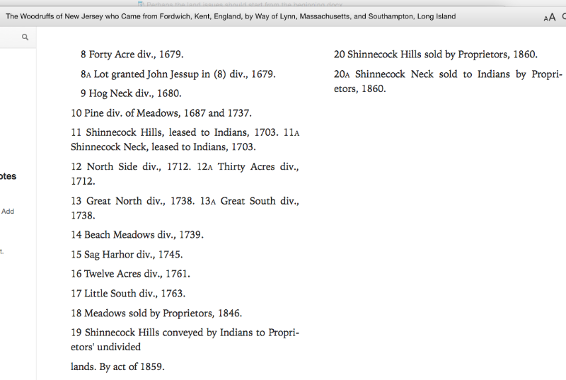
The great division of lands from the 17th - 19th centuries.. note the line from the Reservation up the creek to Bull Head Bay.  I wonder what CBM bought his 200 acres for?


... and along the way I note that one of the pupils of William Merritt Chase's art Colony adopted and developed his realist style... I wonder if CBM & JW found any potential windswept sand dune bunkers like the one pictured below from a 1933 study on their infamous rides at NGLA?  Anything in noted in CBM related books to exposed holes in the sand dunes?

I'd bet this would qualify as a little bungalow..


nice to look at, how nature created things out on Long Island


« Last Edit: June 06, 2015, 08:42:16 PM by Steve Lang »
Inverness (Toledo, OH) cathedral clock inscription: "God measures men by what they are. Not what they in wealth possess.  That vibrant message chimes afar.
The voice of Inverness"

MCirba

  • Karma: +0/-0
Re: Was C.B. Macdonald's routing of NGLA
« Reply #1283 on: June 06, 2015, 05:35:51 PM »
David,

Those were the holes he "found" on his first few trips around the property and the only ones he mentioned.  I don't think many of the others were so obvious and required much more detailed study and planning.

I find it very telling that even over 20 years later all he mentions finding are those same four holes.

Steve,

Great stuff, thanks!  Any idea what Sabin paid for his purchases?
« Last Edit: June 06, 2015, 07:36:44 PM by MCirba »
"Persistence and determination alone are omnipotent" - Calvin Coolidge

https://cobbscreek.org/

DMoriarty

  • Karma: +0/-0
Re: Was C.B. Macdonald's routing of NGLA
« Reply #1284 on: June 06, 2015, 07:47:25 PM »
Typical Cirba.
- CBM told us that the location of the first and last holes were located 200-300 yards from the yet to be built Shinnecock Inn, and Mike takes this as strong evidence that CBM hadn't yet begun routing or planning the golf course.
- CBM provided a detailed description (including actual carry distance) of a hole was half underwater at the time and would need to be built (rather than found), and Mike takes this as strong evidence that CBM hadn't yet begun routing or planning the golf course.  

To Mike, facts are clay. No matter what the facts, he just molds them to fit his preconceived conclusions.

For those willing to be a bit more sincere with their interpretations, here again is CBM's description of the Cape Hole, much of which (including the green) would need to be built by dredging and filling.
"At the narrow end of Bullshead Bay, where the promontory joins the mainland, is an opportunity for a perfect water hazard to be arranged of varying widths so that a strong driver with a following wind may attempt a 240 yard carry to the green, it will also be possible to take a shorter angle to the fair green and to get home in two . . .."
Golf history can be quite interesting if you just let your favorite legends go and allow the truth to take you where it will.
--Tom MacWood (1958-2012)

John Kavanaugh

  • Karma: +0/-0
Re: Was C.B. Macdonald's routing of NGLA
« Reply #1285 on: June 06, 2015, 07:53:42 PM »
David,

And to you friends are like a bungalow. Where most go for shelter you release your bowels.

DMoriarty

  • Karma: +0/-0
Re: Was C.B. Macdonald's routing of NGLA
« Reply #1286 on: June 06, 2015, 08:07:37 PM »
Steve,.

I am pretty sure that one horse is committing suicide rather than face the horrors of the impenetrable brambles on the Sebonac Neck parcel.

Regarding Sabin's property, I just read recently that he donated 95 acres (his stock farm) for the Southhampton Golf Club in 1925

As for whether or not there were any exposed dunes, from the looks of the 1938 Aerial it sure seems like their could have been.  And the Bunker at the Sahara and the bunker at the Leven were both huge early on, and both looked like they could have been there naturally.  And in one of the photo from the 1908 article recently posted, it looks like there were some natural bunkers along the bluff on the Peconic.   But I couldn't say for certain.  
« Last Edit: June 06, 2015, 08:09:10 PM by DMoriarty »
Golf history can be quite interesting if you just let your favorite legends go and allow the truth to take you where it will.
--Tom MacWood (1958-2012)

Steve Lang

  • Karma: +0/-0
Re: Was C.B. Macdonald's routing of NGLA
« Reply #1287 on: June 06, 2015, 08:38:14 PM »
 8) David,

Sabin was quite a guy.  I read that his Landscape Architect, Marian Coffin, had them buy a farm to strip its topsoil for the lawn and gardens at Bayberry Land.. I wonder if that stripped farm was or became  the stock farm?  Not a lot or organic matter in the soil column on top of the dunes... must have been unsuitable for farming, nearly worthless!
« Last Edit: June 06, 2015, 09:40:43 PM by Steve Lang »
Inverness (Toledo, OH) cathedral clock inscription: "God measures men by what they are. Not what they in wealth possess.  That vibrant message chimes afar.
The voice of Inverness"

Patrick_Mucci

Re: Was C.B. Macdonald's routing of NGLA
« Reply #1288 on: June 06, 2015, 08:56:20 PM »
8) Resurfacing after a week back at work, I was wondering:

1) Does anyone know when a "stymie gauge," as shown on the NGLA scorecard, was brought into/out of use?

Steve,

I just saw Babe Ruth's score card from a round he played at GCGC in 1938.

On the score card was the "stymie" measure.

Most, if not all, score cards contained the measure until the stymie was eliminated.

I think the stymie was "official" from 1941 to 1952.

Although, versions date back to 1920 and 1938

]

Patrick_Mucci

Re: Was C.B. Macdonald's routing of NGLA
« Reply #1289 on: June 06, 2015, 09:13:16 PM »
Back to another point that has been touched up in the thread.

With respect to the original locations of the 1st and 18th holes, shouldn't the plaster model (which I understand was started some time in 1907, and correct me if I'm wrong on that) give us a good idea as to the initial configuration?

From the looks of it, both holes were doglegs, and there was room in the middle.


With respect to the 18th, the first part of the hole is right on the water in the model.  Today there is 50 to 70 yards of land between the hole and the Bay.  Did the hole get moved inland a bit or was a lot of fill done to move the coastline out or was the model not exact at that level?

Bryan, again, your lack of familarity with the property continues to lead you astray.

One of the reasons that the 18th tee can't be moved across the road provides the answer to your question.
Take a look at Gogle Earth, it should help


Certainly the 1st is a dogleg if you play it out to the right. 
It looks pretty straight if you take the aggressive line over the left side bunkers. 


Risk - Reward

The line over the bunkers is  fraught with danger, but, if pulled off, the approach shot is ideal
A tee shot hit right is safe, but, leaves the golfer with a blind shot into a very, very difficult green.


The 18th is less obviously a dogleg unless you play out right off the tee.  The picture below shows two lines to play the holes.  No doubt Patrick, our resident playing expert, can fill us in on how practical these alternate routes are.  The c.1929 drawing certainly shows a straight line from tee to green.

My dear friend, Terry McBride, an exception player and long time member of NGLA had two rules on the tee when playing # 18.
Rule # 1.   Don't hit it in the leftside fairway bunker.
Rule # 2.   Go back and read rule # 1.

For the better golfer, hi-tech has somewhat rendered that bunker obsolete.
But, if you go to a makeshift tee back 50 yards, by the gate, even for the long hitters, that bunker comes into play.

The shot of choice is out to the right, which brings you to the center or right side of the fairway.
From their, it's blind up the hill to one of the great skyline greens in golf.


As to the room in the middle, the section where the clubhouse now sits is about 70 yards wide from the left edge of the 18th fairway to the left edge of the left bunkers on the 1st.  That's the way it's represented on the model.  The middle section is about the same width as the 18th fairway.  The 18th fairway today is about 70 yards wide, hence the middle section was about 70 yards across.

For perspective, the clubhouse currently is about 25 yards deep, back to front.  That doesn't leave much room on either side of the clubhouse separating it from the possible lines of play on the 1st and 18th.  So, yes, there is some room there but it is a snug fit.  I doubt very many organizations would build a clubhouse in such a tight space today with all the liability issues.  But then, I'm reminded that Cabot Links clubhouse is immediately adjacent too the 18th green, so it is done even today.

Bryan, there's a famous photo of the 18th hole in the clubhouse at NGLA, depicting a golfer playing his 3rd shot from the roof of the clubhouse.
So, the clubhouse is clearly a target for very errant shots

The clubhouse is really far off line from the tee on # 1 and for 2nd shots on # 18, but, it's possible that it can be hit on both holes.


Patrick_Mucci

Re: Was C.B. Macdonald's routing of NGLA
« Reply #1290 on: June 06, 2015, 09:22:03 PM »
Pat,

CBM wrote that you want to be alone with nature right after telling us he first offered the developer $200 per acre for 120 acres near the Shinnecock Canal, smack dab in the middle of a planned housing development.

120 acres that would have a golf course, and not homes on it.

Mike, what ever happened to that "planned housing development"


He also wrote the more than 3 blind shots was abhorrent and that 50 yard wide fairways were ideal.  
Like many people there was sometimes a gap between what he wrote and said, particularly 20+ years after the fact, and what he did.  

I agree, and that's why I know that he always intended the clubhouse to be sited where it currently stands ;D


I'm not the one who came up with the real estate plan, Macdonald did.  Whigham called it ingenious in 1906.

Have you played in Scotland and England?

Yes, starting in 1952.
 

Many of the courses there are in town and many are near housing.

That's because the town and houses were there first.

The town of Southampton was three mile removed and there was no housing in 1906.


Patrick_Mucci

Re: Was C.B. Macdonald's routing of NGLA
« Reply #1291 on: June 06, 2015, 09:37:40 PM »
Back to another point that has been touched up in the thread.

With respect to the original locations of the 1st and 18th holes, shouldn't the plaster model (which I understand was started some time in 1907, and correct me if I'm wrong on that) give us a good idea as to the initial configuration?

From the looks of it, both holes were doglegs, and there was room in the middle.


Sven,

I agree there was land in the middle. It might have been left for a future clubhouse, but I am not convinced it was "unequivocally" intended originally for clubhouse as Pat contends, because:

1. It makes sense that a hole nears the water would hug the bluffs

    The 18th hole hugs the water.


2. It makes sense that a hole named valley would be placed in the natural valley.....

    So now your theory is that CBM named the holes first, then designed/constructed them ?


3. CBM left a similar amount of wiggle room in many areas

    Locate and identify them !


4. If he did intend it to be the clubhouse, he sure didn't do any pre-planning studies, because it wasn't big enough for pro shop, the parking is not exactly adjacent, etc.  Not that it had to be done to more modern standards, but it never struck me as being well planned.

Two items.

1  CBM was a member of GCGC.
    The GCGC proshop is NOT part of the main clubhouse, but, detached and nearer the first tee.
     Almost the identical set up at NGLA.
     Coincidence ?  Or Planned ?   I go with planned.

2   Tell us, how was CBM going to access his clubhouse near the Shinnecock Inn when he had no road leading to that area of the property.
     Where was he going to put his parking lot "near" his clubhouse, "near" the Shinnecock Inn

Just take a look next door, at Sebonack.
Would you say that they located their parking lot in the perfect location close to the clubhouse ?
The parking lot at NGLA is located perfectly.
What's more important when designing a golf course, siting your parking lot or siting the holes on your golf course ?


Just my perspective, and of course, I could be wrong.  Time may tell.

You, Mike Cirba and others have failed to answer my question.
If the model that Sven posted was crafted prior to April, 1908, isn't that irrefutable evidence that CBM always intended to site his clubhouse at it's current location ?

A simple YES or NO answer will suffice.

Now, let's look at the other factors which you and others have continually ignored.

CBM was thrown out of SHGC.
Would he site his clubhouse underneath the SHGC clubhouse ?
Would he have the SHGC members looking down on him ?
Would he site his brand new clubhouse next to a public/commercial hotel ?
Would he site his clubhouse in an area of the property that had no motor vehicle access.

Or would he site his clubhouse on what he called an "unexcelled site" ?


Steve Lang

  • Karma: +0/-0
Re: Was C.B. Macdonald's routing of NGLA
« Reply #1292 on: June 06, 2015, 09:39:54 PM »

Steve,

... Any idea what Sabin paid for his purchases?

Here's report from Brooklyn Daily Eagle of 3-20-20 of what he paid I believe for the one Feb 1920 land purchase of several used to accumulate the estate's 314 acres. I don't see acres reported in reference, one needs to go to records.  Of course he was buying the property from his own company, nice way to keep things under control..


Charlie Sabin could afford it.. talk about connected, look at all the Directorship positions held


Reference Directory of Directors 1917-18

« Last Edit: June 07, 2015, 12:51:27 PM by Steve Lang »
Inverness (Toledo, OH) cathedral clock inscription: "God measures men by what they are. Not what they in wealth possess.  That vibrant message chimes afar.
The voice of Inverness"

DMoriarty

  • Karma: +0/-0
Re: Was C.B. Macdonald's routing of NGLA
« Reply #1293 on: June 06, 2015, 09:58:34 PM »
Bryan,  A few comments along the same lines as Patrick's comments.

1.  The model shows the 18th right along the edge of a bluff, below which the ground is about at sea level, and is shown on the 1904 Atlas as being almost all water.  Today that area is the location of a pond and the practice area, but back then I am not even sure it was considered useable land.  [I have seen the model, but I don't recall seeing a date. The earliest publication of a photo of the model (that I've seen) is from early 1914.]

2. The current 18th is still pretty much along the edge of the same bluff, as depicted in on the model.  

3. I don't think the "circa 1929" rendering above was actually created in 1929.  The map in Scotland's Gift (published 1928 shows two routes, one the direct line, and one the dogleg.  

4. All the early depictions of NGLA that I have seen show the 18th as a dogleg, unless a big driver plays directly over the left bunker.  In 1909 Whigham described the hole in his discussion of holes utilizing "principle of the 'Dog's Hind Leg:'"

Another splendid example is the 9th [now 18th] hole; 480 yards with a gradual slope uphill all the way. The big driver can carry the bunker in a direct line and by doing so can practically get home in two, or so near home as to have a good chance at four. The poorer driver has to play more to the right, and then is confronted with a big carry for his second if he wants to play straight on the hole. If he is afraid of it he must play his second ball to the left, making his third a long and very difficult approach. The green itself, by the way, standing on a bluff 60 feet above Peconic Bay, rivals Point Garry at North Berwick for picturesqueness.

So Whigham discussed three routes; the direct route, the dogleg route, and the double dogleg route.  The first and last are depicted on a sketch included with the article:


Note the green is tight to the bluff, and described as on the bluff above Peconic Bay.

I guess now we'll argue about whether the double dogleg route played too close to the clubhouse location.

Golf history can be quite interesting if you just let your favorite legends go and allow the truth to take you where it will.
--Tom MacWood (1958-2012)

Jeff Fortson

  • Karma: +0/-0
Re: Was C.B. Macdonald's routing of NGLA
« Reply #1294 on: June 07, 2015, 01:09:50 AM »
Admittedly, I haven't really read the last 25-30 pages of this thread so I apologize if this has been covered or discussed, but I have a simple question or two.

When were the "practice holes" (current driving range) built?

If they weren't built at the same time as the course, is there any evidence that the location and/or idea to build them were pre-determined at the time of construction of the golf course?

#nowhitebelt

Bryan Izatt

  • Karma: +0/-0
Re: Was C.B. Macdonald's routing of NGLA
« Reply #1295 on: June 07, 2015, 03:48:44 AM »
Sven,

That's a good point but it also suggests that planning for the Inn, both in terms of location and size, happened independent of Macdonald and his eventual plans to locate his course there and deciding to use that as his clubhouse.

Would you agree that it reads as if they would have made it larger (it was only 30 rooms to accommodate Shinnecock and National members as well as motorists) if they had known Macdonald ' s intent before planning/building?


There was another Shinnecock Inn built in the late 1880's near Old Fort Pond. It burned down before SHPBR bought the land.  It was SHPBR that decided they needed to build another inn for their recently acquired development, and they decided to also called it the Shinnecock Inn.  Building of the Inn was underway by Dec 1, 1906 according to Brooklyn Life.


Goddard says the site selection near NGLA by SHPBR was deliberate because they expected NGLA members to contribute to the clientele.  No doubt they would have made CBM aware.  They wanted to sell him the property and  have him become the anchor owner in their new development. No doubt he knew exactly where the Inn would be when he optioned the property.

So, no, I don't think the planning for the Inn happened independently of the Macdonald.  The Inn and NGLA were going to be mutually beneficial.  I can't see any point in trying to draw any inference from CBM saying 200 - 300 yards.


Patrick_Mucci

Re: Was C.B. Macdonald's routing of NGLA
« Reply #1296 on: June 07, 2015, 07:37:00 AM »
Mike & Bryan,

Would you admit that if the plaster model Sven posted was crafted pre-April 1908 that it proves, unequivically, that CBM always intended to site his clubhouse in it's current location.

A simple, "YES" or  "NO" will suffice.

Thanks

MCirba

  • Karma: +0/-0
Re: Was C.B. Macdonald's routing of NGLA
« Reply #1297 on: June 07, 2015, 08:51:37 AM »
Patrick,

I would agree that if the model was built prior to 1906 then CBM was superhuman.
"Persistence and determination alone are omnipotent" - Calvin Coolidge

https://cobbscreek.org/

MCirba

  • Karma: +0/-0
Re: Was C.B. Macdonald's routing of NGLA
« Reply #1298 on: June 07, 2015, 09:13:47 AM »
Steve,

The purchase I'm most curious about is the one Sabin made in 1917 or 1918 of over 300 acres next to NGLA.  It would be interesting to see what he paid per acre.  He also bought 20 acres from CBM IN 1920 on land that I believe was west of today's 8th and 9th holes as per an article I posted many pages back.

Also, i know you disagree but why do you think MacDonald wrote that everyone thought the land of Sebonac Neck was more or less worthless?
"Persistence and determination alone are omnipotent" - Calvin Coolidge

https://cobbscreek.org/

MCirba

  • Karma: +0/-0
Re: Was C.B. Macdonald's routing of NGLA
« Reply #1299 on: June 07, 2015, 09:49:53 AM »
Bryan,

I have the Goddard book and saw that passage but it does seem as if Goddard is speculating and not basing his statement on anything but the circumstantial evidence.
"Persistence and determination alone are omnipotent" - Calvin Coolidge

https://cobbscreek.org/

Tags:
Tags:

An Error Has Occurred!

Call to undefined function theme_linktree()
Back