All,
It's interesting that Patrick refers to "Scotland's Gift" as "The Bible", because although I agree with David that it's a remarkably accurate recollection of events over 20 years after the fact, it's much like the other Bible in that it's open to interpretation, particularly in relation to events around the creation of National Golf Links of America.
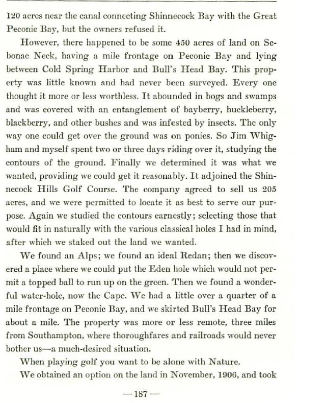
I thought it might be a revealing exercise to ask folks to interpret the two pages in question, taking each event described and telling us if they feel the event happened
A) Before the land was secured in late 1906,
B) During the Pre-Construction Planning phase from Dec 06 to May 07,
C) During Construction and Grow-In, or
D) After the course was built and opened.
Here again are the two pages in question;


I'll take a shot and welcome others to do the same;
First, I think the first section from the offer on the 120 acres near the canal through the description of the Sebonac Neck property as well as the 2 or 3 horseback rides as well as deciding it was what they wanted if they could get it reasonably is obviously
A, prior to securing the land.
Second, I think the company agreeing to sell 205 acres and permitting them to locate it as best suited their purposes is what took place in Nov/Dec 1906, as it's almost exactly what was reported in the press the weekend after the deal was signed on December 14, 1906. I think they spent the next several months as Macdonald was quoted in Dec 06,
"Distances and the holes to be reproduced will be decided on by the committee in the next five months." So A, running through B.In the next sentence CBM starts with
"Again we studied the contours earnestly; selecting those that would fit in naturally with the various classical holes we wanted, after which we staked out the land we wanted."I think this section perfectly describes what Macdonald described as the
B phase, with that work taking place between December 06 when he secured the land to May 07 when boundaries were determined and construction began.
Here again in Macdonald's words, as quoted in December 1906.
"We have a stretch at our disposal of four acres in width and two miles long. The exact lines will not be staked out until the committee has finished its plans, for latitude has been given to use in this respect, as all concerned want the course to be ideal."Next, Macdonald tells us about finding landforms for the Alps, and redan, and Eden and Cape. He further describes the general characteristics of the land they selected. I believe this has to be
A, prior to securing the land, as the news reports in Dec 06 have him describing the exact same thing. Further, I find it impossible to believe that two trained eyes like Macdonald and Whigham wouldn't have seen that long, broad rise of the Alps hole during their first two or three horseback trips around the property.
"We have a stretch at our disposal of four acres in width and two miles long...Bullshead bay will be skirted for about a mile and at the end of the point there is an opportunity to reproduce the famous short hole at St. Andrews. But there are other opportunities as delightful - for instance, to duplicate the Redan hole at North Berwick. When Whigham saw a certain knoll with me cried out, "We will make a better Alps hole than at Prestwick!"Then Macdonald tells us when they secured an option on the land and when that land went to final sale, which we've since learned was June of 1907, so this is all
B timeframe, as well. Next he refers to commencing development and having to bring in soil in places which is all clearly during
C, or construction.Then he tells us about the lack of funds for a clubhouse and the need to use the Shinnecock Inn for the purpose, and notice how he says because of that fact,
"our intention was to have the first hole close to the Shinnecock Inn." He did not design the golf course and then the Shinnecock Inn just subsequently happened to be built there. He designed the golf course with the starting and ending points near the Shinnecock Inn because that's where he had to for convenience to that building. This all happened during
C, as did the subsequent fire that burned the Shiinnecock Inn to the ground.
Next, Macdonald goes back to discussing the design phase, or actually, to trying to find landforms for the replica holes he wanted which I believe takes us back to
A, back to before the land was secured when he writes that his first steps were about locating the Alps, the landform for the redan, the Eden, and Cape. Of course, he could theoretically be talking about "place(ing) those holes on the ground during construction, but that seems unlikely. I think he was telling us that those were the first holes he wanted to place, or fit, into any routing
Thanks, and I welcome others to do this exercise and similarly explain their rationale. It might go a long way towards illuminating where we agree and where we don't and help others understand our opinions, as well. Thanks.