News:

This discussion group is best enjoyed using Google Chrome, Firefox or Safari.


Patrick_Mucci

Re: Was C.B. Macdonald's routing of NGLA
« Reply #550 on: May 21, 2015, 09:18:21 PM »
Here are the properties from the tax rolls on the parcel maps Steve posted above, with the addresses and acreage from the tax rolls.

David,

You've left off the land between White's Lane and Sebonac Inlet Rd, which is owned by NGLA.

In fact, the old entrance gate to the clubhouse, on White's Lane remains, west of Sebonac Inlet Rd.

There's another piece of property west of White's Lane that's been owned by a long time member and I wonder if that parcel was once owned by NGLA and sold to that member decades ago.

And,, I believe that NGLA owns the land south of White's Lane, to the boundary line.


DMoriarty

  • Karma: +0/-0
Re: Was C.B. Macdonald's routing of NGLA
« Reply #551 on: May 21, 2015, 09:59:34 PM »
Patrick, 

It is a bit confusing to look at, but I am going by the lin gray lines which denote the different parcels.  So the land between Sebonac Inlet Rd. and the old entry road is included in the 129 Acre parcel, as is the land on the other side of the old entry road, all the way to Scrubland Rd. Then the 52.6 Acre parcel starts on the other side of Scrubland (which I think is also called Sebonac.)

I only marked the parcels that showed up under National Golf Links or National Golf Course on the tax roll.
Golf history can be quite interesting if you just let your favorite legends go and allow the truth to take you where it will.
--Tom MacWood (1958-2012)

Steve Lang

  • Karma: +0/-0
Re: Was C.B. Macdonald's routing of NGLA
« Reply #552 on: May 21, 2015, 10:09:20 PM »
 8) Some more measurements... fyi these total 219 acres, neglecting the Bull Head Bay shoreline and inlet road


and a check back to the blueprint, look larger than the GIS based area and there's some small shape difference, looks a little wider and more N-S oriented

« Last Edit: May 21, 2015, 10:37:12 PM by Steve Lang »
Inverness (Toledo, OH) cathedral clock inscription: "God measures men by what they are. Not what they in wealth possess.  That vibrant message chimes afar.
The voice of Inverness"

MCirba

  • Karma: +0/-0
Re: Was C.B. Macdonald's routing of NGLA
« Reply #553 on: May 21, 2015, 10:14:18 PM »
Pat,

I understand and largely agree how all of those things ultimately determined the routing.

But you're still talking about the golf course as it became by sometime in 1907, not what was envisioned in late 1906 when CBM secured 205 acres consistent with his agreement with the Founding members down to the exact acreage.  Over the next five or so months, that all changed.
« Last Edit: May 21, 2015, 10:16:09 PM by MCirba »
"Persistence and determination alone are omnipotent" - Calvin Coolidge

https://cobbscreek.org/

Patrick_Mucci

Re: Was C.B. Macdonald's routing of NGLA
« Reply #554 on: May 21, 2015, 10:33:48 PM »
Pat,

I understand and largely agree how all of those things ultimately determined the routing.

But you're still talking about the golf course as it became by sometime in 1907, not what was envisioned in late 1906 when CBM secured 205 acres consistent with his agreement with the Founding members down to the exact acreage.  

That's where we disagree.

CBM had routed the course prior to obtaining the option in 1906.

CBM purchased the land based upon his routing and that routing had nothing to do with any understanding with the founding members. 


Over the next five or so months, that all changed.

Nothing changed between the fall of 1906 and the Spring of 1907.

The design of the course was set in stone when CBM decided what land he wanted to option in the fall of 1906.


DMoriarty

  • Karma: +0/-0
Re: Was C.B. Macdonald's routing of NGLA
« Reply #555 on: May 21, 2015, 10:42:06 PM »
Mike you keep saying it was "down to the exact acreage" but 205 does not equal 200.
« Last Edit: May 21, 2015, 10:44:36 PM by DMoriarty »
Golf history can be quite interesting if you just let your favorite legends go and allow the truth to take you where it will.
--Tom MacWood (1958-2012)

JESII

  • Karma: +0/-0
Re: Was C.B. Macdonald's routing of NGLA
« Reply #556 on: May 21, 2015, 10:47:31 PM »
Mike you keep saying it was "down to the exact acreage" but 205 does not equal 200.

Nor does it equal 165...


Pat,

Why did CBM say they still needed to figure a lot of it out over the next several months?

DMoriarty

  • Karma: +0/-0
Re: Was C.B. Macdonald's routing of NGLA
« Reply #557 on: May 21, 2015, 10:59:40 PM »
Thanks Ed.  That is to what I was referring. 

______________________________________
Mike and Jim,

I addressed Steve's first set of measurements in post 515.   
Golf history can be quite interesting if you just let your favorite legends go and allow the truth to take you where it will.
--Tom MacWood (1958-2012)

DMoriarty

  • Karma: +0/-0
Re: Was C.B. Macdonald's routing of NGLA
« Reply #558 on: May 21, 2015, 11:02:43 PM »
Steve,

I've been trying to use your first course measure (165 yards) in an overlay I was working on.  I can't get it to line up with other aerials.  Any chance it got distorted somewhere in the process?
Golf history can be quite interesting if you just let your favorite legends go and allow the truth to take you where it will.
--Tom MacWood (1958-2012)

DMoriarty

  • Karma: +0/-0
Re: Was C.B. Macdonald's routing of NGLA
« Reply #559 on: May 22, 2015, 12:02:23 AM »
Also Steve,  I'm trying to make sense of your latest numbers.  Any idea why your numbers a bit different from the county's?   For example you have the area N of the road at 170.5 acres (148.5+22) where the county has 185.5.  I've tried to measure it myself and my number is much closer to the county's number.   With the area S of the road you get 46.5, where the county gets 52.6.
Golf history can be quite interesting if you just let your favorite legends go and allow the truth to take you where it will.
--Tom MacWood (1958-2012)

Bryan Izatt

  • Karma: +0/-0
Re: Was C.B. Macdonald's routing of NGLA
« Reply #560 on: May 22, 2015, 12:34:15 AM »
Jeff,

Thanks for the explanation.  Patrick, of course, has subsequently added more bluster to his non-answer.

But regarding your answer, my question would be: does the rising/setting sun impact on a hole not depend on the time of year and your latitude?  On my home course the 18th is directly into the setting sun for a period in mid summer when the sunset is 30* north of due west.  In spring and fall the sunset is 30* off of directly into our eyes.

I agree that the tee shot at the 1st at NGLA is indeed maybe a little south of east.  That would suggest to me that the sunrise might be a problem in March and September, October.  The 18th starts a little north of west so I'd expect some issue a little later in the spring and earlier in the fall.  

But, Pat was talking about topography, not planetary orbits.  Maybe there are some mountains out there east and west on Long Island that block out the rising and setting suns at NGLA.   ;D  But, we'll never know because Pat rarely follows up with any real answers.


Two other thoughts as David and Mike are getting tedious.

The current 1st hole runs to the east and into the rising sun.  The current 18th runs to the west and into the setting sun.  Was it not part of the design ethos in the early 1900's not to do that.  The originally intended 1st and 18th both run north-south avoiding the rising and setting sun issue. Maybe CBM really intended to avoid the sun issue and that was another reason he originally started at the south end of the property.

Bryan,

This is where your ignorance puts you at a disadvantage.

If you were familiar with and understood the topography you'd know that the rising and setting sun aren't a problem.


Could you explain how the topography means the rising and setting sun aren't a problem please.

The source I've seen also suggests he made another overseas trip in late 1906 and early 1907 and following that trip that he winnowed down his template holes from Scotland and his original concept holes to his final 18.  Anybody aware of this trip?  Can it be verified through ship manifests?

Why don't you check with the source that provided that suggestion ?

I got it from the source.  What good would asking again do?  Vetting it through the manifests would give independent verification (or not), but then you knew that before your unhelpful response.


Bryan,

The most likely reason sun isn't a huge issue on hole 1 is it faces more E to SE. Holes facing NE are the ones that have to deal with the early morning setting sun, especially on the water/sea level with no hills, structures, etc. to block the sun for the first few hours after it rises.

But, like the sun rising every morning, Patrick has taken the opportunity to call someone ignorant!

Bryan Izatt

  • Karma: +0/-0
Re: Was C.B. Macdonald's routing of NGLA
« Reply #561 on: May 22, 2015, 12:38:46 AM »

Steve,

Don't you know that topo map is worthless because Patrick says they can't tell that that's a private driveway and not Whites Lane in the middle of it.   ;)


Just kidding of course.  I think it's a really good topo map.


8) Sven,  there's probably enough indicators or line extensions to get pretty close outline on Google Earth and measure it up.  The GIS topo viewing looks interesting.  Must have been a really nice horseback riding area, other than the bugs when the wind was down..


Steve Lang

  • Karma: +0/-0
Re: Was C.B. Macdonald's routing of NGLA
« Reply #562 on: May 22, 2015, 12:45:54 AM »
 8) Dave,

 I would not be surprized if lot lines and surveys don't reconcile, especially from old vs new plats and survey drawings used for tax records with the county clerk vs GE data.  Many a benchmark are MIA and lots modified by adverse possession, things filled in and roads moved...  

I tried to calibrate my area measurements on the distance between Whites Ln, and old Shrubland Road and then a straight width of Shrubland that crosses the course both off of GE.  The last measurements were made after pasting into Acrobat, applying a scale ratio for my benchmark distances and using the measuring tool.  A bad scale ratio could be the cause of the 5-10% delta, or simply where the mouse traced...

In regard to the 170 vs 185, I'm guessing perhaps the road and space to the shoreline that I didn't include ???  ???

In regard to the south area, I was wondering about the width of things  at Shrubland Rd.

WE can test if you want to send me your files and I'll see if they change when ported or measured between my programs.
« Last Edit: May 22, 2015, 01:08:08 AM by Steve Lang »
Inverness (Toledo, OH) cathedral clock inscription: "God measures men by what they are. Not what they in wealth possess.  That vibrant message chimes afar.
The voice of Inverness"

Bryan Izatt

  • Karma: +0/-0
Re: Was C.B. Macdonald's routing of NGLA
« Reply #563 on: May 22, 2015, 12:53:41 AM »
Bryan,
I think the various parcels may have been more a matter of disassembly than "assembly."  

Not sure what you mean by disassembly.  Are you suggesting that the little parcels were broken off from the larger parcel?  Would it be logical to disassemble a little piece and then sell it to themselves?  Seems more likely to me that they didn't buy the little stuff to the east of the road initially because it was part of what CBM needed.  The club may have acquired it later for privacy. All just speculation so far.

I punched the addresses off the tax rolls into the GIS viewers, and it looks like at least some the 185 Acre parcel is the main golf course parcel, and at least some of the smaller parcels are on the east side of Sebonac Inlet Road.  (The even addresses are on east of the road.)  So for example, the 7.4 acre parcel is that little thumb to the east of the road near Ram's Island, and the 4.0 parcel is just north of that, etc.. Of course road acreage needs to be substracted out.

The 52.6 acre parcel is a bit of a mystery as the address doesn't pop up on the viewer, but my bet is that it is the parcel between Bullshead, Bay, Sebonac Inlet Road, Barker's Island Road, and White's Ln. (Undeveloped land but not part of the golf course.)

I see you now agree that it is likely the piece south of Shrubland Rd.  What persuaded me is that if you plug the address into Google Maps, the address comes up on E Rd, the dirt path up the middle of the southern section of NGLA.  I guess that the E Rd was once an extension of Sebonac Rd and that Google picked up that name and location from their mapping source (maybe Suffolk County).

ADDED: I see our posts crossed.  See my comments on the 52.6 acre parcel.

Bryan Izatt

  • Karma: +0/-0
Re: Was C.B. Macdonald's routing of NGLA
« Reply #564 on: May 22, 2015, 12:59:01 AM »
David,

Just curious, did you measure these or just attribute the acreages to what looks like the likely property? They look likely to me too.  The deeds might help us nail it down definitively.

Here are the properties from the tax rolls on the parcel maps Steve posted above, with the addresses and acreage from the tax rolls.


Bryan Izatt

  • Karma: +0/-0
Re: Was C.B. Macdonald's routing of NGLA
« Reply #565 on: May 22, 2015, 01:03:57 AM »

Mike, 

I'm not convinced that that's where the 20 acres was.  It could have been part of Ballyshear or some other property we don't know of.


I am enjoying it too David but I'm still curious how the exercise is going to get us to the original metes and bounds of the 205 acres acquired in 1907?  Still, it is fun to watch.

Also keep in mind that at some point CBM owned 20 acres adjacent to the west of his 8th and 9th hole which he sold to Charles Sabin in 1920.  I'm not sure where that fits in the puzzle.

Bryan Izatt

  • Karma: +0/-0
Re: Was C.B. Macdonald's routing of NGLA
« Reply #566 on: May 22, 2015, 01:09:13 AM »

Interesting.  No, I didn't notice the difference but I find the blueprint really hard to see/read.  I need to do some more searching, because I haven't yet found the tax roll for the 2.5 acre property.  I'm not sure if David found it either.


8) Boundary Business -1, for your enjoyment...

Did anyone notice the difference between the blueprint NW boundary and the aerials or GIS plot?


just wondering..

post-dinner, it turns out to measure 2.5 acres


DMoriarty

  • Karma: +0/-0
Re: Was C.B. Macdonald's routing of NGLA
« Reply #567 on: May 22, 2015, 01:13:18 AM »
Bryan,

The reason I think it "disassembly" is because the road along Bullshead Bay wasn't there when the course opened.  At some point after the road got built it must have been deeded over to the county (let the county pay to maintain it) but not the small bit of land between the road and the water.  So those pieces got broken off by the road but still belonged to NGLA.

(The road may also help explain part of the reason the property seems to have substantially grown over the years.  Some eastern sections of the course used to be the swampy shores of Bullsead Bay, but have since been filled.)

As for the 52 acre parcel, I thought it funny that the address popped up on google maps but did not the county viewer.  Maybe patrick is onto something.

Golf history can be quite interesting if you just let your favorite legends go and allow the truth to take you where it will.
--Tom MacWood (1958-2012)

DMoriarty

  • Karma: +0/-0
Re: Was C.B. Macdonald's routing of NGLA
« Reply #568 on: May 22, 2015, 01:17:39 AM »

Interesting.  No, I didn't notice the difference but I find the blueprint really hard to see/read.  I need to do some more searching, because I haven't yet found the tax roll for the 2.5 acre property.  I'm not sure if David found it either.


8) Boundary Business -1, for your enjoyment...

Did anyone notice the difference between the blueprint NW boundary and the aerials or GIS plot?

Bryan and Steve, I did notice that the area for the proshop is not included on the blueprint.  Bryan, this is one of the reasons I think that the 2.5 acre purchase was the proshop.

As for the "tax roll" it is included in the "185.3 Acres" at 129 Sebonic Inlet Road.
Golf history can be quite interesting if you just let your favorite legends go and allow the truth to take you where it will.
--Tom MacWood (1958-2012)

Bryan Izatt

  • Karma: +0/-0
Re: Was C.B. Macdonald's routing of NGLA
« Reply #569 on: May 22, 2015, 01:28:52 AM »
This stuff is not easy to do.  Metes and bounds of deeds is probably the most exact way, but even that is difficult with the tools we have available.  Finding deed metes and bounds starting points that were relevant in the early 1900's is not so easy now.

I'll give the measuring a shot when I get a chance (baby sitting grandkids this week), but I imagine in advance that it'll come out close to the county's numbers.

Assuming the county's acreages are right and the property outlines are about right, the two main properties are 237 acres.  CBM supposedly bought 205.  Where the heck are those extra 32 acres.  The current property outline doesn't look much different than the early map we've looked at many times and assumed that it defined the boundaries.  Whatever variances we see don't seem to add up to 32 acres.


8) Dave,

 I would not be surprized if lot lines and surveys don't reconcile, especially from old vs new plats and survey drawings used for tax records with the county clerk vs GE data.  Many a benchmark are MIA and lots modified by adverse possession, things filled in and roads moved...  

I tried to calibrate my area measurements on the distance between Whites Ln, and old Shrubland Road and then a straight width of Shrubland that crosses the course both off of GE.  The last measurements were made after pasting into Acrobat, applying a scale ratio for my benchmark distances and using the measuring tool.  A bad scale ratio could be the cause of the 5-10% delta, or simply where the mouse traced...

In regard to the 170 vs 185, I'm guessing perhaps the road and space to the shoreline that I didn't include ???  ???

In regard to the south area, I was wondering about the width of things  at Shrubland Rd.

WE can test if you want to send me your files and I'll see if they change when ported or measured between my programs.

Bryan Izatt

  • Karma: +0/-0
Re: Was C.B. Macdonald's routing of NGLA
« Reply #570 on: May 22, 2015, 01:41:19 AM »
David,

Quote
Maybe patrick is onto something.

Seems quite unlikely to me on this subject.   ;D :o

__________________________________________


Re the 2.5 acres, did you see something in the tax rolls that told you it was included in the 185.3 acres.  Or, are you deducing it?  The 2.5 acres was bought a few years after the main property.  What would be the legal process to integrate the 2.5 acres into the larger property after the fact.  If the main property was in fact one piece when CBM bought it, and was split afterwards, what would the legal process be for that?


Interesting.  No, I didn't notice the difference but I find the blueprint really hard to see/read.  I need to do some more searching, because I haven't yet found the tax roll for the 2.5 acre property.  I'm not sure if David found it either.


8) Boundary Business -1, for your enjoyment...

Did anyone notice the difference between the blueprint NW boundary and the aerials or GIS plot?

Bryan and Steve, I did notice that the area for the proshop is not included on the blueprint.  Bryan, this is one of the reasons I think that the 2.5 acre purchase was the proshop.

As for the "tax roll" it is included in the "185.3 Acres" at 129 Sebonic Inlet Road.

DMoriarty

  • Karma: +0/-0
Re: Was C.B. Macdonald's routing of NGLA
« Reply #571 on: May 22, 2015, 01:56:06 AM »
Steve and Bryan,

You guys are probably aware of this but at the viewer Bryan linked earlier (
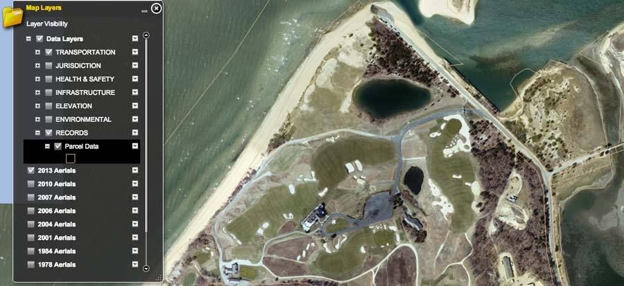
http://gis2.suffolkcountyny.gov/GISViewer/) there is a "Parcel Data"  setting showing the individual parcels from the tax rolls (very light lines.)(  A screen shot of the setting . . .


Steve you mentioned offline that you have Google Earth Pro. Perhaps the best way to get an accurate acreage is to pull the parcel layer into GEP and measure using the advanced tools.  Or you could use my images below.  I hate to make up thing for you to do, but if the mood strikes you . . . something to kill time while you are waiting on the discussion of the fire.
________________________________

Speaking of the blueprint, I have been messing around a scan (of George's scan) and it is pretty interesting.  The lines aren't perfect but they are close, except for the area to the east of the Sahara, Alps, and Hogsback.   As was mentioned the pro shop area is not on the blueprint.

From looking closely at the map, I am beginning to develop some theories on how the course was mapped out.   It looks like CBM first found green sites, then had Raynor survey straight line (center line) elevations from green to green, bunkers and tees ("T") were probably added later, although some natural bunkers might have been there from the beginning.  

In short, I think the blueprint cuts against the idea that CBM had the property fully surveyed with elevations before it was planned.  In order to do straight line surveys, you need starting and ending points, and the starting and ending points seem were the greens themselves.  So the greens came first, then the elevations.  At least on this survey.

Here is the overlay showing the parcel data (yellow) along with the blueprint border (red) as best as I could fit it. (And the shoreline off the blueprint (orange.))


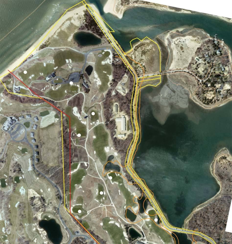
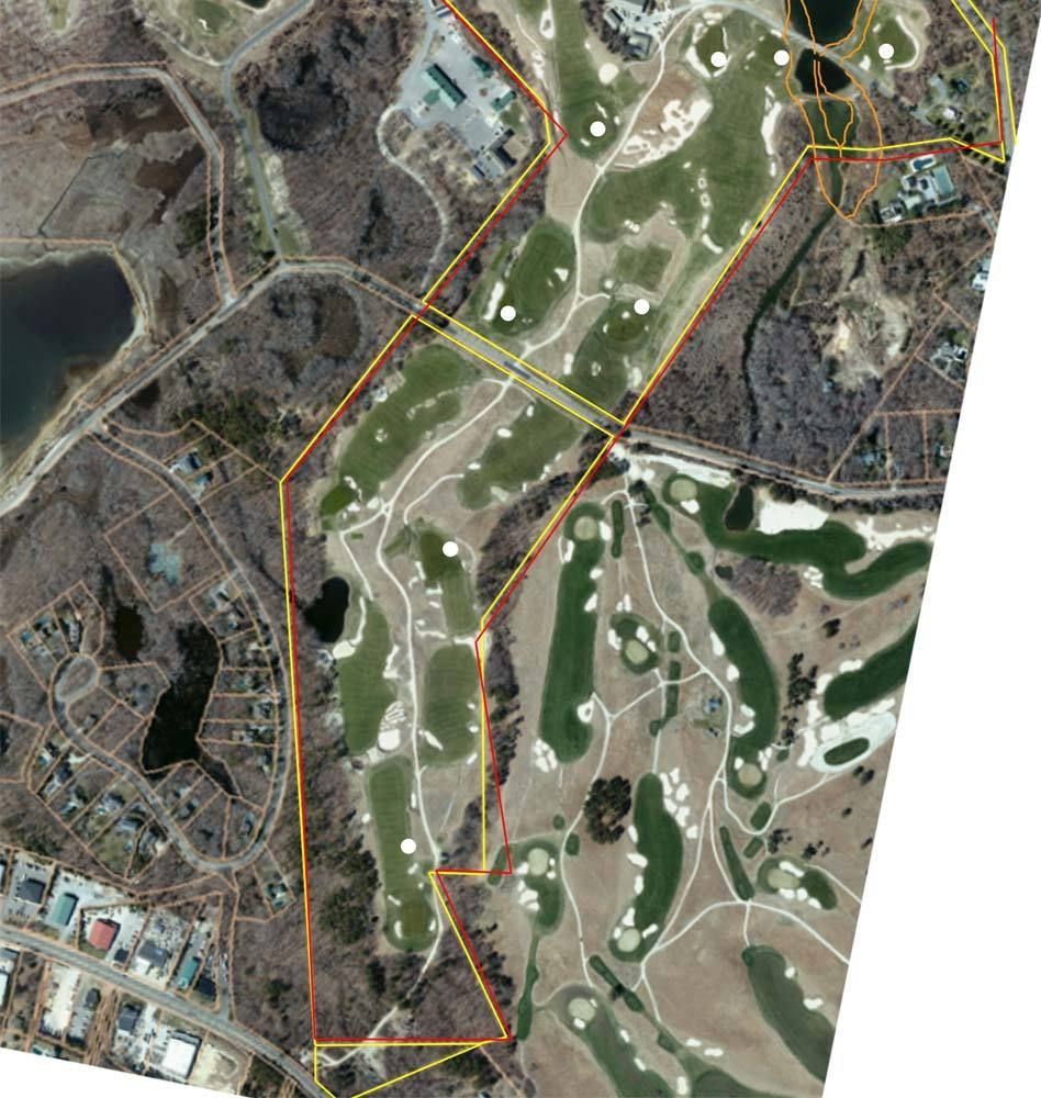
Some of the green sites off the survey are marked as well (white.) I tried to use these for alignment.
Golf history can be quite interesting if you just let your favorite legends go and allow the truth to take you where it will.
--Tom MacWood (1958-2012)

DMoriarty

  • Karma: +0/-0
Re: Was C.B. Macdonald's routing of NGLA
« Reply #572 on: May 22, 2015, 02:14:44 AM »
.3 acres.  Or, are you deducing it?  The 2.5 acres was bought a few years after the main property.  What would be the legal process to integrate the 2.5 acres into the larger property after the fact.  If the main property was in fact one piece when CBM bought it, and was split afterwards, what would the legal process be for that?

I looked up the parcel on the Viewer and one can see that the "129 Sebonac Inlet Rd" Parcel includes the pro shop area.  For that matter it includes the clubhouse area as well. And the pro shop area isn't on the blueprint so I deduced it was added after the blueprint was created.

I am no property or tax lawyer, but I think that, generally, contiguous parcels can be consolidated provided certain conditions are met (exact same owner in same name, no liens, restrictions, etc, similar tax classification, etc.

If I had to bet on why 340 Sebonac Inlet Rd. is not consolidated with 308 Sebonac Inlet Rd., I'd bet it is because 340 is owned by 'National Golf Club' whereas 308 is owned by 'National Golf Links of America.' 
Golf history can be quite interesting if you just let your favorite legends go and allow the truth to take you where it will.
--Tom MacWood (1958-2012)

DMoriarty

  • Karma: +0/-0
Re: Was C.B. Macdonald's routing of NGLA
« Reply #573 on: May 22, 2015, 02:39:40 AM »
This stuff is not easy to do.  Metes and bounds of deeds is probably the most exact way, but even that is difficult with the tools we have available.  Finding deed metes and bounds starting points that were relevant in the early 1900's is not so easy now.

Assuming the county's acreages are right and the property outlines are about right, the two main properties are 237 acres.  CBM supposedly bought 205.  Where the heck are those extra 32 acres.  The current property outline doesn't look much different than the early map we've looked at many times and assumed that it defined the boundaries.  Whatever variances we see don't seem to add up to 32 acres.

First, while I think the metes will help us understand the western border, I doubt deeds will be much help with the eastern border.  My guess is that the deeds describe the boundary ("bound") as  Bullshead Bay and the Peconic.  Generally (depending on navigability and on the jurisdiction) this would mean that he owned up to the high water line.  Looking at the blueprint, the eastern boundary is very different today than it was in 1906. 

This also may also start to explain from where the 32 came. Take the 12 acre triangle at the northwest corner for example.  On the 1904 map that is almost all water.  So it may not have been part of the 32 acres.  And a substantial bit along the eastern border was swampy.  This gets us part of the way there.
Golf history can be quite interesting if you just let your favorite legends go and allow the truth to take you where it will.
--Tom MacWood (1958-2012)

Patrick_Mucci

Re: Was C.B. Macdonald's routing of NGLA
« Reply #574 on: May 22, 2015, 08:17:36 AM »
Jeff,

Thanks for the explanation.  Patrick, of course, has subsequently added more bluster to his non-answer.

Bryan,

Anyone who has played NGLA understands my answer.
It's your ignorance that causes you to categorize my response as "bluster"
Likewise, Jeff doesn't have a clue about playing NGLA


But regarding your answer, my question would be: does the rising/setting sun impact on a hole not depend on the time of year and your latitude?  On my home course the 18th is directly into the setting sun for a period in mid summer when the sunset is 30* north of due west.  In spring and fall the sunset is 30* off of directly into our eyes.

I agree that the tee shot at the 1st at NGLA is indeed maybe a little south of east.  That would suggest to me that the sunrise might be a problem in March and September, October.  The 18th starts a little north of west so I'd expect some issue a little later in the spring and earlier in the fall.  
You moron, of course the tee shot is a problem on # 1 in March.
The course is closed in March, you can't play it.


But, Pat was talking about topography, not planetary orbits.  Maybe there are some mountains out there east and west on Long Island that block out the rising and setting suns at NGLA.   ;D  But, we'll never know because Pat rarely follows up with any real answers.

You're getting warmer.

If you were familiar with the topography, the dates and hours of operations, you'd have figured it out by now.

This is what happens when you present yourself as being knowledgeable about NGLA, when you really don't have a clue.

As I said, we're all ignorant, just about different topics, and NGLA is one of yours.😆,


Two other thoughts as David and Mike are getting tedious.

The current 1st hole runs to the east and into the rising sun.  The current 18th runs to the west and into the setting sun.  Was it not part of the design ethos in the early 1900's not to do that.  The originally intended 1st and 18th both run north-south avoiding the rising and setting sun issue. Maybe CBM really intended to avoid the sun issue and that was another reason he originally started at the south end of the property.

Bryan,

This is where your ignorance puts you at a disadvantage.

If you were familiar with and understood the topography you'd know that the rising and setting sun aren't a problem.


Could you explain how the topography means the rising and setting sun aren't a problem please.

The source I've seen also suggests he made another overseas trip in late 1906 and early 1907 and following that trip that he winnowed down his template holes from Scotland and his original concept holes to his final 18.  Anybody aware of this trip?  Can it be verified through ship manifests?

Why don't you check with the source that provided that suggestion ?

I got it from the source.  What good would asking again do?  Vetting it through the manifests would give independent verification (or not), but then you knew that before your unhelpful response.


Bryan,

The most likely reason sun isn't a huge issue on hole 1 is it faces more E to SE. Holes facing NE are the ones that have to deal with the early morning setting sun, especially on the water/sea level with no hills, structures, etc. to block the sun for the first few hours after it rises.

But, like the sun rising every morning, Patrick has taken the opportunity to call someone ignorant!

Tags:
Tags:

An Error Has Occurred!

Call to undefined function theme_linktree()
Back