News:

Welcome to the Golf Club Atlas Discussion Group!

Each user is approved by the Golf Club Atlas editorial staff. For any new inquiries, please contact us.


JESII

  • Karma: +0/-0
Re: The Pine Valley Deeds
« Reply #425 on: December 13, 2011, 09:02:20 PM »
Which topo?

The 1953 one Bryan posted doesn't necessarily agree with you although it doesn't go out North too far...

My recollection of Google Earth is that it does agree with you but I don't remember where that fits in your accuracy continuum. Which topo shows a substantial drop from right to left?

DMoriarty

  • Karma: +0/-0
Re: The Pine Valley Deeds
« Reply #426 on: December 13, 2011, 10:03:15 PM »
They all do.    Even the bit of the 1953 topo posted by Bryan shows the ground dropping from over 150 ft to less than 100 ft over a short distance, from right to left.
« Last Edit: December 13, 2011, 10:06:14 PM by DMoriarty »
Golf history can be quite interesting if you just let your favorite legends go and allow the truth to take you where it will.
--Tom MacWood (1958-2012)

Patrick_Mucci

Re: The Pine Valley Deeds
« Reply #427 on: December 14, 2011, 03:18:37 AM »

Patrick,

Re your pictures of the current impenetrable forest along the tracks, I think you said this picture you took shows (or not) the tracks from the 17th.  Are these trees not all deciduous?

NO, they're not ALL deciduous trees.


 Do you suppose it would be easy to see through them now, in the winter?

See through them into what ?
A high, steep incline that blocks any view south of the RR tracks


And, by the way, there are no pictures that you posted that show a view from anywhere near the 6th green looking to the 3rd tee area.  


I think the 10th photo comes close
I'll have David post more.
You can't see a thing


You posted many on pg 44 of the Pine Valley Topos thread from 6 fairway looking back towards the 6th tee and along the edge of the ridge, but
nothing looking at the angle we've been talking about.  You had claimed a page or two ago that you had posted one of that angle.  If you did, it's
gone.

I'll have David post more.
You can't see a thing

« Last Edit: December 14, 2011, 03:23:40 AM by Patrick_Mucci »

Bryan Izatt

  • Karma: +0/-0
Re: The Pine Valley Deeds
« Reply #428 on: December 14, 2011, 03:46:22 AM »

In my browsing of the American Golfer of March 1914, I came across the following quote from Crump in a funny duck story written by Hazard:

"In front of my bungalow, at Pine
Valley, I have created an artificial lake
of considerable dimensions, and it occurred
to me that it would be very
desirable if I could get some wild
ducks to frequent it."

So, I guess that means that he built 5th hole pond.  The question remains as to whether he built it between November 1912 and February 1913 - before the topo map was completed.  I think it unlikely, but this seems to prove that he built the pond, and it wasn't there when he purchased the land.  This is consistent with other contemporaneous stories saying that the stream was still a stream in 1913.
 

Bryan Izatt

  • Karma: +0/-0
Re: The Pine Valley Deeds
« Reply #429 on: December 14, 2011, 11:35:26 AM »
Pat,

OK, they are not ALL deciduous.  Would you agree on mostly?

If you could post a picture from near the green pointing toward the 3rd tee and if the view is blocked by pine trees then I guess that would prove that we can't use that method to try to replicate what was visible from that point in 1913 and use that to validate the Brown photo.

Bryan Izatt

  • Karma: +0/-0
Re: The Pine Valley Deeds
« Reply #430 on: December 14, 2011, 12:17:33 PM »
David,

I meant your discussion with Jim was moot to me because the photo appeared to me to be pointed in the opposite direction.  I wasn't trying to suggest it was moot to you or Jim.  Carry on.

To assist, here is another view of the picture, somewhat cleaned up and maybe a little more clear. 

If the picture is oriented toward the 2nd tee and first fairway locations, I'd be curious as to what field of view you think is covered.  At the distance of the 2nd tee and 1st fairway locations, where is the left edge of the picture and where is the right edge?  What do you see from the foreground to the middle of the picture?  I see the land dropping steeply away from his feet and then more gently to the white line coming out of his right hip.  From there it appears to me to rise gently and then steeply up the far hill.  To me, that doesn't fit at all with the topography looking from the 3rd tee in that direction.  The land should continue to drop another 20 feet over another 1000 feet past the RR. And, Lake Lekau should be out there somewhere in the right half of the picture, depending on the angle it is taken.

The 1913 topo shows a a falling away from the 3rd tee, more steep at the beginning and then uniformly from there to the teeing area.  A modern picture (albeit from the opposite direction) shows a sharp ridge near the green and a flatter fairway (Jim and Patrick could tell us what it looks like on the ground).  Old pictures of the ridge show it to be less abrupt - at least to me.

The caption reads as follows:

"                                           PINE VALLEY.
The new course in New Jersey near Philadelphia. Looking over the rolling country from the third
teeing-ground. The ground is being cleared rapidly and the fairways and putting-greens prepared
for seeding."

The caption provides no hint as to what direction it is looking over "rolling country", so I suppose it could be looking toward the first, or the sixth or even across the 4th or across the short course.

To me the foreground doesn't match the topography of the land as I understand it. If somebody had a picture looking back down the 2nd that might help validate or not.
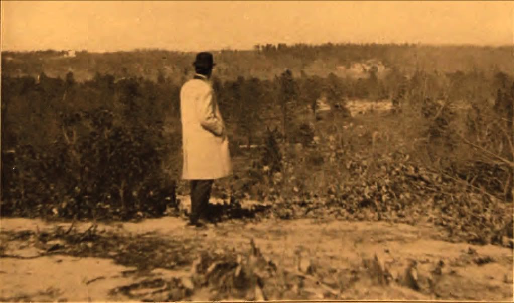


(from Robert Thompson's blog)


Jeff_Brauer

  • Karma: +0/-0
Re: The Pine Valley Deeds
« Reply #431 on: December 14, 2011, 12:25:57 PM »
Bryan,

I don't know, but it looks like a pretty steep drop to me right behind Crump.  And there is that road midway down, which shows up on the 1898 topo (gravel, of course)  I also see a steep, bare bank in the background that looks like some of the knobs near the small pond on the 1898 topos.  We know if he was looking at six, what it would look like from other photos.  We also presume he is looking over his own property and not the property next door west.  If looking east, we would probably see the steep ravine that would become five pond.

So, all in all, while not certain, looking at 2 tee seems to make the most sense from the features we can see.

Not sure it proves much about anything in the thought process of PV.

Cheers.
Jeff Brauer, ASGCA Director of Outreach

John_Cullum

  • Karma: +0/-0
Re: The Pine Valley Deeds
« Reply #432 on: December 14, 2011, 12:58:23 PM »

To try to get back to  a more productive discussion, ...

Because the potential is so great
"We finally beat Medicare. "

JESII

  • Karma: +0/-0
Re: The Pine Valley Deeds
« Reply #433 on: December 14, 2011, 01:07:02 PM »
Bryan,

The white house in the top left matches the while house in the left side of the Brown picture from 6. This alone makes me certain the cameras were pointing the same direction. The very different looks in the foreground makes me pretty certain they are taken from different places on the property

There is a real difference in the grade up to the second tee/third tee ridge in the 1913 topo than in real life today. It's more gradual initially then much more abrupt in the last 50 yards. Jeff has said this is one of the sites the EPA tested and said had some mining activity. I wonder if ther tests in those days were perfect at deciphering between major sand mining operations and relatively minor excavation.

Jeff_Brauer

  • Karma: +0/-0
Re: The Pine Valley Deeds
« Reply #434 on: December 14, 2011, 01:14:58 PM »
Jim,

Before anyone goes ballistic, I only know that there was an EPA report and TePaul told me it appeared as if the mining was in the large bank generally facing the railroad.  It also makes sense that they would mine the shortest haul areas, but I reall don't know if those sandy areas by No. 1 and 2 were mined or not.

What little I know about early mining operations in general, but not specific to PV, is that they were remarkably small to what came later and shown by someone in photos on this or another PV thread.

That said, I think I see a steeper drop off in front of Crump and figure it was made steeper in construction by digging those bunkers out and piling it up on 2 green or 3 tee.  And I believe the RR might very well be blind from 3 tee, because it would be cut in on the high side and filled on the low side.  The cut on the high side might hide it from the camera view.

How bunkers were cut and where the fill went, i.e. just how much construction was there, would be a topic of interest to me, and we get some hints on the photo of 3 green.  I have commented before that the Colt plan bunkering isn't followed, so I wonder what/who Crump's inspiration was?  I also note that the bunkers on 2 and 3 have very flat top edges, so he wasn't a great 3D thinker/shaper of features, more stragetically oriented, I think.  And, who really ran the horse and mules?

Cheers.
Jeff Brauer, ASGCA Director of Outreach

JESII

  • Karma: +0/-0
Re: The Pine Valley Deeds
« Reply #435 on: December 14, 2011, 01:20:22 PM »
That's true Jeff, sorry.


DMoriarty

  • Karma: +0/-0
Re: The Pine Valley Deeds
« Reply #436 on: December 14, 2011, 03:04:31 PM »
Bryan,  I thought we already figured that Crump built the pond, and that the question is when?    Not sure that quote helps in this regard.    I am still very surprised that you are willing to assume that whoever created the map was adding large features like ponds and dams even though, in your opinion, they did not yet exist!  That seems to undermine your theory that the 1913 topo is a useful guide to understanding what was there pre-construction.   What else might he have added in?  The road? Tree lines?  Planned changes in elevations?  If the map reflects some projection into the future, then what good is the map for telling us what was there at the time the map was created?  

As for your theory about the camera facing away from the RR, how do you reconcile that with the matching background between the two photos?

As for what I think I see, I think I see an embankment down then rising ground about the level of the end of the white patches on the right, then we cannot see so I assume another slope down, the back up on the far hill.  In other words I see much the same thing as in the other picture, but from ground level.  
« Last Edit: December 14, 2011, 03:17:56 PM by DMoriarty »
Golf history can be quite interesting if you just let your favorite legends go and allow the truth to take you where it will.
--Tom MacWood (1958-2012)

DMoriarty

  • Karma: +0/-0
Re: The Pine Valley Deeds
« Reply #437 on: December 14, 2011, 03:19:31 PM »
Why would the caption describe it as "rolling country" if it was looking back toward the second tee and first green?
Golf history can be quite interesting if you just let your favorite legends go and allow the truth to take you where it will.
--Tom MacWood (1958-2012)

JESII

  • Karma: +0/-0
Re: The Pine Valley Deeds
« Reply #438 on: December 14, 2011, 04:35:07 PM »
David,

There is a very distinct intermediate ridge in the Brown photo that I do not see on this one. Do you see it? Can you draw a line across its top edge?

Thanks.

DMoriarty

  • Karma: +0/-0
Re: The Pine Valley Deeds
« Reply #439 on: December 14, 2011, 04:55:42 PM »
Jim,

I am not really sure what I see.   My initial thought was that dark trees across the middle of the photo were growing on the intervening ridge.  So the ridge line would be in those dark trees (I guess about where you put your RR.)


But I don't have as strong a sense about this photo as I do the other one.  For the other one, it seems like the geometry makes the caption impossible.  For this one it could just be my eyes playing tricks on me, or it could be that my unfamiliarity with the site makes it difficult for me to see it your way. 
Golf history can be quite interesting if you just let your favorite legends go and allow the truth to take you where it will.
--Tom MacWood (1958-2012)

DMoriarty

  • Karma: +0/-0
Re: The Pine Valley Deeds
« Reply #440 on: December 14, 2011, 05:08:50 PM »
Back to the elevation issue for a minute.   There is a Benchmark (95 ft) marked in the 1953 map at approximately the location of the RR station.   The benchmark was established in 1924, and the elevation was marked as 94.832 ft. above mean sea level.  Here is a photo . . .


And a photo of the location . . .


The marker is set in a foundation for an old signal tower, and the foundation appears to be visible on the high resolution image from the USGS server.

According to the National Geodetic Survey data page, a previous survey control adjusted the elevation to 94.72 ft, and it has subsequently been adjusted to 93.58 feet.   So while not exact at the 95 ft. the benchmark from the 1953 elevation map is very close.  

The resolution of the 1/9 NED data is fair at best for this point, and the reading is 93.08 feet.    Again not perfect but not 10 yards off either.    

Golf history can be quite interesting if you just let your favorite legends go and allow the truth to take you where it will.
--Tom MacWood (1958-2012)

JESII

  • Karma: +0/-0
Re: The Pine Valley Deeds
« Reply #441 on: December 14, 2011, 05:25:12 PM »
Do you think we can use that elevation as fact and determine some of the basic elevations near the property line to learn anything about the 1913 topo?

DMoriarty

  • Karma: +0/-0
Re: The Pine Valley Deeds
« Reply #442 on: December 14, 2011, 05:37:43 PM »
The 1913 topo doesn't extend to the RR tracks, much less to the other side of the tracks.   But I do think that this Benchmark strongly suggests that the USGS topos (from 1953 on) are pretty accurate.  The 1/9 NED  looks to be pretty close as well.  Google Earth elevation is at 96 for this point, which is also not far off.

While these data points are not exactly the same, there is a pretty close grouping.  The 1913 topo seems to be a outlier in comparison to them all.
Golf history can be quite interesting if you just let your favorite legends go and allow the truth to take you where it will.
--Tom MacWood (1958-2012)

JESII

  • Karma: +0/-0
Re: The Pine Valley Deeds
« Reply #443 on: December 14, 2011, 05:53:20 PM »
No, but it goes just about to the fence doesn't it? The tracks are only a dozen feet from the fence.

Truthfully, I hadn't paid great attention to the debate the two of you had regarding the topos and absolute elevations but the enhancement Bryan presented on post 1619 of the other thread shows contour lines down near the fence not far from the block you're looking at here.

JESII

  • Karma: +0/-0
Re: The Pine Valley Deeds
« Reply #444 on: December 14, 2011, 06:31:48 PM »
They all do.    Even the bit of the 1953 topo posted by Bryan shows the ground dropping from over 150 ft to less than 100 ft over a short distance, from right to left.


I didn't want to lost this. I disagree. I don't have the full versions of the other maps, but Google Earth does not agree with you. There are various ups and downs, but when looked at as a two dimensional view (because a ridge 500 yards away would block a depression 800 feet away) I don't think there is a severe drop from right to left. Rather I think there may be a gradual left to right drop. Although we haven't agreed on a camera perspective yet so it's unlikely we'll resolve this first.

JESII

  • Karma: +0/-0
Re: The Pine Valley Deeds
« Reply #445 on: December 14, 2011, 06:47:31 PM »
Jim,

I am not really sure what I see.   My initial thought was that dark trees across the middle of the photo were growing on the intervening ridge.  So the ridge line would be in those dark trees (I guess about where you put your RR.)

---------------------------------------------------------------------------------------------------------------------

But I don't have as strong a sense about this photo as I do the other one.  For the other one, it seems like the geometry makes the caption impossible.  For this one it could just be my eyes playing tricks on me, or it could be that my unfamiliarity with the site makes it difficult for me to see it your way. 


David,

You say the geometry makes the 6th fairway photo impossible in your view yet you refuse to actually post how much of the distant ridge/trees are visible in the Brown picture. I don't get it...why the reluctance to state your position? I only see 20 feet or so of trees in the left side of that picture  which seems like a non-issue regarding the geometry. Unless you see 60 or 80 feet of ridge/trees I can't imagine how it's an impossibility...


Now, it's impossible that the two photos were both taken from the 6th fairway with the one supposedly from the third tee being at ground level and the other being elevated in some way because there is so much more of the distant ridge visible...which would be impossible from a lower height, right?

Bryan Izatt

  • Karma: +0/-0
Re: The Pine Valley Deeds
« Reply #446 on: December 14, 2011, 07:48:30 PM »
David,

Nice find on the benchmark plate.  What site is it from. Never mind, I found it - scaredycatfilms.com?   ???   I once saw a nerd site where people searched out the BM's and posted pics.

The 1913 topo doesn't go right to the track, but the the land was sloping down to the tracks in a pretty linear fashion.  The contour line nearest the tracks was 100 feet.  If you extrapolate the slope on the 1913 topo to the tracks you'd get a 95 foot contour near where the plate is.  Certainly proof of nothing, but worth a thought.  

Did you find a picture/history for the BM on Pine Hill.  It was there in 1898 and it seems likely that that would have been where the surveyor would have started.  It was the nearest BM on the older maps.  And it appeared to change elevation more in the 3 to 4 foot range.  Still, interesting considerations on the differences in elevation, but still not conclusive about the causes or the amounts or the extent of the differences over the property.  Never mind.  I found the site and there is little historical info for this site, although it does date from the 1800's.  Thought the latest recovery note was interesting.   :( 

"JU3014                          STATION RECOVERY (2006)
 JU3014
 JU3014'RECOVERY NOTE BY PMK GROUP 2006 (RMF)
 JU3014'STATION IS LOCATED IN ATV TRAIL.  DISK IS MISSING AND IT APPEARS THAT
 JU3014'SOMEONE TRIED TO DRAG IT OUT OF POSITION WITH CHAINS.
"

I'm still not hung up on the absolute differences.  I know you seem to be.  But, in a similar vein to Jim's question - what will knowing the cause of the differences or what the amount of the difference is tell us about the contouring on the 1913 topo.  I'm trying to focus on the contouring and relative differences between contours.  Are you feeling that if the absolutes are wrong, then the contours might be wrong too?  A honest question - no hidden agendas.


« Last Edit: December 15, 2011, 02:04:24 AM by Bryan Izatt »

Bryan Izatt

  • Karma: +0/-0
Re: The Pine Valley Deeds
« Reply #447 on: December 15, 2011, 12:10:52 AM »

To try to get back to  a more productive discussion, ...

Because the potential is so great

I agree, but nobody seems to want to go there.  Better to debate jungle forests, fast moving trains, captions of pictures, hard to read photos ......

Bryan Izatt

  • Karma: +0/-0
Re: The Pine Valley Deeds
« Reply #448 on: December 15, 2011, 12:30:04 AM »
Bryan,

The white house in the top left matches the while house in the left side of the Brown picture from 6. This alone makes me certain the cameras were pointing the same direction. The very different looks in the foreground makes me pretty certain they are taken from different places on the property

There is a real difference in the grade up to the second tee/third tee ridge in the 1913 topo than in real life today. It's more gradual initially then much more abrupt in the last 50 yards. Jeff has said this is one of the sites the EPA tested and said had some mining activity. I wonder if ther tests in those days were perfect at deciphering between major sand mining operations and relatively minor excavation.

Yes, the background including the white object, seem similar and the foregrounds look quite different.  One was supposedly taken from the 6th fairway, the other from the 3rd teeing ground, so i would expect the foregrounds to look different.  I guess that the fore and middle ground in the 3rd tee picture don't fit my mind's eye of what it should look like.

As an exercise I took the 1913 topo of the 2nd hole and laid it on the Google Earth aerial using the 1st and 2nd greens and the property boundary to align the two.  I then plotted elevation profile of the 1913 topo and GE up the middle of the fairway from 1913 tee to the green.  There are the issues we've been debating with the two data sources, yet I thought the outcome might be informative if not absolutely provable.  Interestingly they start at the same elevation, more or less, and then diverge after 100 feet or so.   Apart from the elevation gap, I'd say it looks like some grading was done to smooth out the last 50 - 100 feet to the green and that the fairway may have been stair-stepped a little bit.

Re the sand mining, we have the 1913 topo but no baseline from before that.  The 1898 topo is too rough.  We could try to get the EPA report and see what it says.


Bryan Izatt

  • Karma: +0/-0
Re: The Pine Valley Deeds
« Reply #449 on: December 15, 2011, 12:57:31 AM »
Bryan,  I thought we already figured that Crump built the pond, and that the question is when?  I know I had concluded that Crump built it.  I thought you still doubted.  Glad to hear that you're onside with that.   As to when, I had posted contemporaneous articles that suggested that it was still a stream after the topo was drawn.  From that, I inferred that it was built after the topo.  As I recall you objected, because surveyors/map drawers wouldn't add future features.  That lead me to believe that you thought it must have been built between November and March.  Could you clarify your opinion, if I've understood it wrongly.  Not sure that quote helps in this regard.    I am still very surprised that you are willing to assume that whoever created the map was adding large features like ponds and dams even though, in your opinion, they did not yet exist!  That seems to undermine your theory that the 1913 topo is a useful guide to understanding what was there pre-construction.   What else might he have added in?  The road? Tree lines?  Planned changes in elevations?  If the map reflects some projection into the future, then what good is the map for telling us what was there at the time the map was created?  I presume the surveyor surveyed the property and drew the topo contours.  We don't know for sure who drew the tree lines or the dam and pond.  Crump might have or he might have asked the surveyor/mapmaker to add them in.  I don't agree with your supposition that drawing features that weren't there at the time detracts from the integrity of the topo contours.  Crump drew fairway lines and greens and tees that weren't there.  Do they detract from the integrity of the contours?  

As for your theory about the camera facing away from the RR, how do you reconcile that with the matching background between the two photos?  I don't reconcile it.  How do you reconcile the fore and middle ground features. My conclusion is that the we don't have enough information or clarity from the picture to come to  a conclusion.  So, I'd go with the contemporaneous caption until some further information comes to light that affirms or denies the caption.  We've spent months and hundreds of posts trying to reconcile the Brown picture and that still hasn't got the collective us anywhere near agreement on where it was taken from or what it shows.  Why waste an equal amount of time and effort on this one to come to the same impasse.

As for what I think I see, I think I see an embankment down then rising ground about the level of the end of the white patches on the right, then we cannot see so I assume another slope down, the back up on the far hill.  In other words I see much the same thing as in the other picture, but from ground level.  To clarify, are you suggesting that they are both from the 6th fairway and the Brown picture was taken from some kind of elevated position?  And the the 3rd tee caption is wrong?  If it was from the 3rd tee, I don't see that there would be a ridge in the way.  The ridge in the way from the 6th tee is the 3rd tee, 2nd green and 4th fairway, where the caption would have us believe that the man in the hat picture is taken from.