News:

Welcome to the Golf Club Atlas Discussion Group!

Each user is approved by the Golf Club Atlas editorial staff. For any new inquiries, please contact us.


DMoriarty

  • Total Karma: 0
Re: The Pine Valley Deeds
« Reply #350 on: December 08, 2011, 09:57:35 PM »
Jim,  Whether you really are or not, Bryan seems quite frustrated with Patrick. 

Without getting into the particular issue of the date of the various aerials, I wish people would simply provide the basis for their factual claims.   It would make these discussions much smoother.
______________________

Bryan, I am curious about your conclusion that the HD image from the USGS is more oblique than the Google Earth image, and wondering how that works over a large area supposedly matched up with particular reference points.    What made you conclude that the one was more oblique?
Golf history can be quite interesting if you just let your favorite legends go and allow the truth to take you where it will.
--Tom MacWood (1958-2012)

JESII

  • Total Karma: 0
Re: The Pine Valley Deeds
« Reply #351 on: December 08, 2011, 10:32:31 PM »
Oh, Pat is definitely frustrating but I assume that's his...charm!!!


I agree with you on providing basis for factual claims.

Patrick_Mucci

Re: The Pine Valley Deeds
« Reply #352 on: December 09, 2011, 12:47:03 AM »
Pat,
Jim,

I just wanted to preserve this reply in an unedited form.
When I have time this weekend, I'll reply to it


Was it honesty or intelligence at play when you presented and April aerial photograph as being from the winter?

Was it honesty or intelligence that had you demanding that the Brown and Shelly captions are identical?

Is it honesty or intelligence behind your continual declarations that the entire property from corner to corner was covered by impenetrable jungle-like forests and underbrush while at the same time telling us Crump knew the land from having hunted through these same impenetrable jungles for years? Why hunt through the impenetrable forest when so much more manageable land is right nearby?

Why do you think Bryan's picture reveals a much greater percentage of deciduous trees than yours?


As far as my asking you about Crump being on an Eastbound train...keep in mind that I was laughing at it possibly being another of your ridiculous qualifiers to questions you want to discuss inside a very confined context. The AWT article hadn't been posted in months and I refreshed my memory soon after...is that the best you got? It makes no difference which direction the train was headed.

Bryan Izatt

  • Total Karma: 0
Re: The Pine Valley Deeds
« Reply #353 on: December 09, 2011, 04:58:38 AM »
David,

More grist for your analytical mill regarding the 1/9 NED data.

Let me start with questions.  Are you using the NJ State Atlas Topo as your basis of "right"?  As we discussed before, it looks  like it came from an individual who has taken physical USGS 7.5 minute quad maps and has digitized and overlaid them with aerial imagery.  Can you identify the source data used in compiling the quad map?  It seems to come from Terraserver, which in turn comes from DigitalGlobe.  I don't see a way to identify when the quad map was printed or what data was used to compile it.  I do see various reports that the quad map elevation resolution could be within 7 meters.  I thought you'd seen numbers that suggested finer elevation resolution than that.

Back to the National Map Seamless Viewer.  More findings for your consideration.

I zoomed in to a small area that encompassed a portion of the left rear part of the 1st green and left from there a little down into the trees.  No particular reason other than there should be some elevation change there and the data looked solid.  The rectangle I selected contained 1x2 cells at 1 arc second, 3x6 at 1/3 arc second and 9x18 cells at 1/9 arc second. 

The data points are at the corners of the cells.

Using the spot elevation tool I looked at two points.  They measured exactly the same elevation (to the hundredth of a foot) regardless of whether I displayed the 1 arc second, 1/3 arc second or the 1/9 arc second shaded  view.  In other words the display buttons on the right only affect the display - the base data behind the display is the same regardless.

The data supporting the display is 1/9 data.

There were some yellow cells indicating missing data in the 1/9 projection.  There was data at those points.  I now agree with you that the missing data is replaced with interpolated data from the neighboring 1/9 data set points.

I downloaded the 1 arc sec, 1/3 arc second and 1/9 arc second data sets for the rectangle.  I got the requisite number of rows and columns.

I plotted the data using Global Mapper.  Using the spot elevation tool in the Seamless Viewer on my two check points I got elevation of 87.49 feet and 93.66 feet.  Sounded reasonable given the fist was down in the trees and the second was up on the green

When I plotted the 1 arc second data, with 0.5 foot contours, the two checkpoints came out the somewhere between 99 and 99.8 feet.  Clearly the 6 total data points were not too useful in contouring.  But, how did the values end up being 6 to 12 feet higher than the spot elevations in the Seamless Viewer.  Only way I can figure, is that they actually pulled the data from a 1 arc second data set and that that data set is 6 to 12 feet higher than the 1/9 data set.  Any other possibilities that you can think of? 

When I plotted the 1/3 data, there was better contouring based on more data points.  My two benchmark point came out at 96.5 and 99.5 feet respectively.  Still 9 to 6 feet higher than the 1/9 data.

When I plotted the 1/9 data, the contours approximated the drop off on the side of the green of 6 feet or so.  The two check points came out at 87.5 and 93.3 feet respectively.  Pretty close to the spot measurements.

So, why would the 1/3 data be 6 to 9 feet higher than the 1/9 data?  If the 1/3 was sampled from the 1/9 data there is no way they could be that much higher.  That suggests to me that the 1/3 data comes from a different data base than the 1/9 data.

In looking at the metadata supplied with each file, that was confirmed.  The 1 arc second and 1/3 arc second data comes from USGS sources.  Presumably from the quad maps.  The source of the 1/9 arc second LIDAR data is credited to the NJ Office of Geographic Information Systems.

So, I'm left with a difference of 6 to 9 feet between the USGS data and the 1/9 data.  Pretty much the same as you're seeing between the 1913 topo and the 1/9 data.  So, using your logic, then the USGS topos have been "wrong" too for many years.

Hence, back to my initial questions.  Which data are the NJ State Atlas topos using, and are they "wrong" too.

The more I read of the whole topo mapping process and with the introduction of new technology the more I'm convinced I'm out of my depth trying to make value judgements on what data is "right" and which is "wrong" in absolute elevations.   I'm even less interested now in the absolute elevation differences.  If the USGS has been "wrong" for many years and the 1913 topo is "wrong" in the same direction and magnitude, then strangely, I feel comfortable that the 1913 surveyor got the contours "right".   

Bryan Izatt

  • Total Karma: 0
Re: The Pine Valley Deeds
« Reply #354 on: December 09, 2011, 05:05:42 AM »

.................................
______________________

Bryan, I am curious about your conclusion that the HD image from the USGS is more oblique than the Google Earth image, and wondering how that works over a large area supposedly matched up with particular reference points.    What made you conclude that the one was more oblique?

Try overlaying the Seamless Viewer high-res ortho onto the GE image from the NJ state Altlas topo.  It requires some adjustment, which I attribute to a more oblique view.  I'm open to other possible reasons.

BTW the SV high-res image is also displaced some from the underlying 1/9 data.  Look at the tracks, for instance. 

DMoriarty

  • Total Karma: 0
Re: The Pine Valley Deeds
« Reply #355 on: December 09, 2011, 10:00:21 PM »
Bryan, the short answer is that I don't think the most recent quad was created using either sets of data you checked.   Not the 1/3 NED and not the 1 AS.   I think the most recent quad was from the 1980's and was based on a planetable survey from 1953, with periodic revisions using photographs after that.  The date of the most recent one I have been able to find today is 1981, but I thought I had seen reference to one from the late 80's but maybe not.  The contours on the one from the NJ Atlas site match the one from 1981, and are very close to the one from 1953.   Does either of the datasets you mentioned match the quads?  I doubt it but I guess it is possible.  

Even if one of those datasets does match the quads, then the 10 feet you have found could not be the same ten feet. The 1913 topo is different to the high side compared to the 1953 survey and later revisions.  You have indicated that the  data sets you spot checked (in one spot) are around 10 feet to the high side of the 1/9 data at least for this particular point.  If what you think you have found for this particular point actually extrapolates to the site (I doubt it does,) and if one of those datasets was used to make the latest quad (again I doubt it,) then this would increase the difference between the 1/9 NED and the 1913 topo.  Instead of being roughly around 10 feet it would be roughly around 20 feet higher than then 1/9 NED. But I am not sure I put much faith in tests of a section of the course where the 1/9 data seems to be very spotty.  

On what basis did you conclude that the data points are at the corners? Each 1/9 tile has a single elevation value so how was this determined if the data points are at the corners? Averaging of the four corners? This seems counter intuitive to me --why would they take specific readings and then immediately diverge from this data?
« Last Edit: December 09, 2011, 10:05:00 PM by DMoriarty »
Golf history can be quite interesting if you just let your favorite legends go and allow the truth to take you where it will.
--Tom MacWood (1958-2012)

DMoriarty

  • Total Karma: 0
Re: The Pine Valley Deeds
« Reply #356 on: December 09, 2011, 10:32:56 PM »
To add to the clutter, here is the "US Topo" for the Clementon quad.  The US Topo USGS digital replacement for the old paper quads.  This one is dated 2011, but the legend indicates that the data came from the NED, 2001.  I don't know which data set they were using in 2001, but I doubt it was the 1/9 NED.   The 1/3 NED maybe? 

Golf history can be quite interesting if you just let your favorite legends go and allow the truth to take you where it will.
--Tom MacWood (1958-2012)

Bryan Izatt

  • Total Karma: 0
Re: The Pine Valley Deeds
« Reply #357 on: December 10, 2011, 01:22:30 PM »
David,

Here are 5 versions, over time, of topo maps for the Pine Valley area.  Some of them indicate on the map when the survey was completed as opposed to when the map was imprinted. For instance the 1898 topo we are familiar with was based on an 1885 survey.

1898 (1885 Survey)
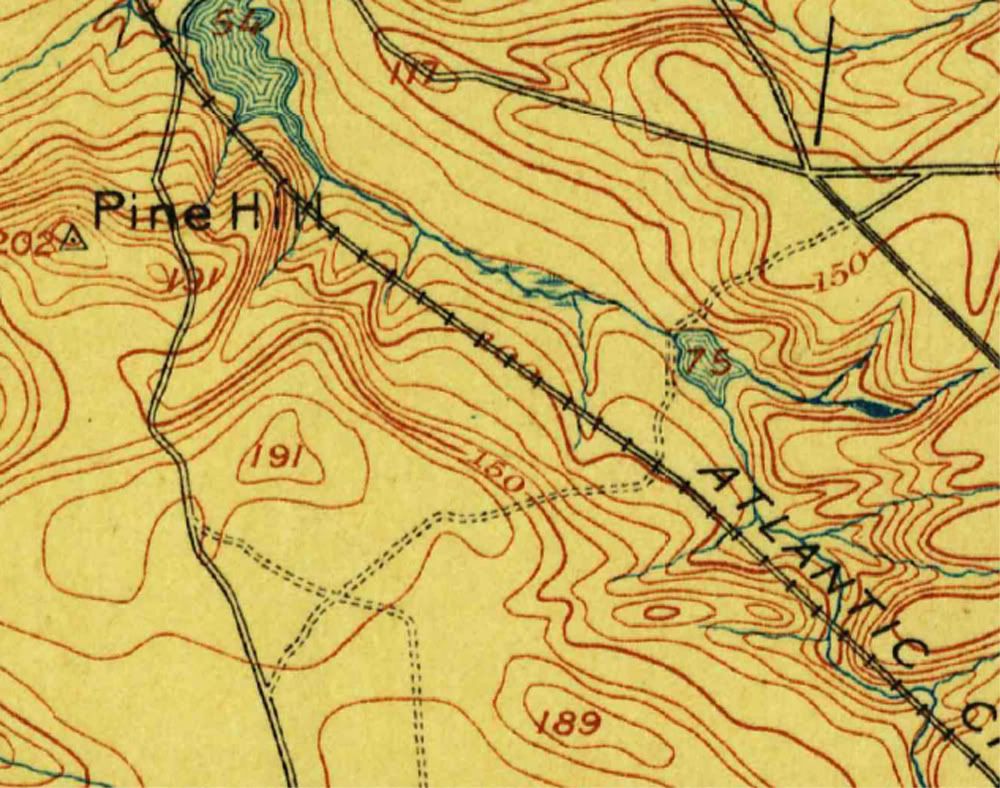


1942 US Army


1953 (1953 Survey)
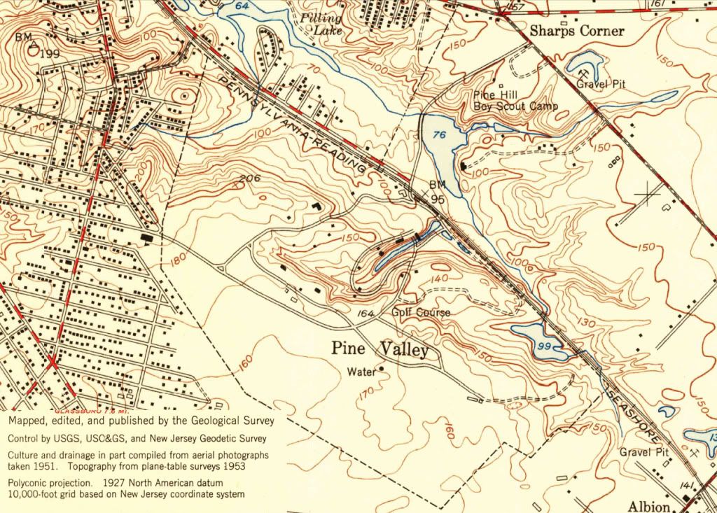


1967 (1953 Survey amended with newer information)
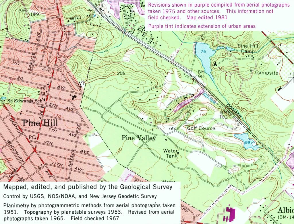


2011 (2001 NED)
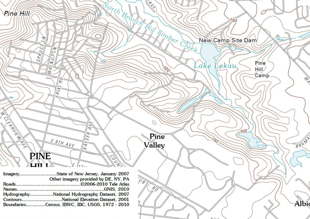


Apart from the differences in the contours, note that the Pine Hill Benchmark (BM) has changed from 202 to 206 to 199 to somewhere more than 190 and less than 200.  I suppose that means that as technology has advanced even the BM's have changed.  Also note how the 189 foot knob to the southwest of the 7th tee seems to have eroded and disappeared over time.

The latest one, based on the 2001 NED (whatever data is included in that) seems to have contours that are more smoothed out than previous versions.  Perhaps they've changed their approach or algorithm for contouring in the last 30 years.  It's interesting that the 170 foot nose down the 7th tee and fairway has also been smoothed out in the 2011 printing.

As best as I can find out to this point, it's not obvious that the base survey data has changed at all since 1953 in this area.  The 1967 map suggests amendments based on aerial photography, but that more likely has to do with the overlay features.  If you can find anything more definitive about what elevation data for this particular area is being used for any specific map or for the NED, I could be convinced otherwise.

I think the 2001 NED was not a new set of data, but rather just a repackaging of the existing data of the time into a database to support the seamless National Map.

From the USGS history:

Quote
The National Map

In 2001, the USGS released its vision for the topographic map of the 21st Century, The National Map, a seamless, continuously maintained, nationally consistent set of base geographic data; developed and maintained through partnerships; a national foundation for science, land and resource management, recreation, policy making, and homeland security; available over the Internet; and the source for revised topographic maps. The National Map, a collaborative effort to improve and deliver topographic information for the nation, consists of eight data layers: transportation, hydrography, boundaries, structures, geographic names, land cover, elevation, and orthographic images. The goal of The National Map is to become the nation’s source for trusted, nationally consistent, integrated, and current topographic information available online for a broad range of uses. The seamless databases constructed in the 1990s and early 2000s became the base data for The National Map, with additional data from federal, state, local, and tribal sources being added.

Quote
The NED

In the 1990s, the USGS moved from quadrangle areas, usually constructed from 7.5-minute, 15-minute, 30-minute or 1-degree areas, to seamless nationwide layer-based datasets. The first of these completed was the National Elevation Dataset (NED), a multi-resolution seamless, nationwide mosaic of elevations created from existing USGS databases of 7.5-minute tiles with 30 m horizontal spacing, 7-meter root mean square error (RMSE), 1-degree tiles with 3-arc-second horizontal spacing, and a vertical RMSE of 30-meter. The USGS has continued to improve the NED with elevations on a 10-meter horizontal spacing that is now available for the conterminous 48 states, and most recently with lidar data generating elevations on a 3-meter horizontal spacing.

The continuous improvement to the 10 meter horizontal spacing I think has led to the 1/3 arc second database, and the LIDAR data for the 3 meter horizontal spacing has led to the 1/9 arc second database.  The metadata for the 1/3 data I downloaded is not specific about the source of the data.  I don't know of another way to figure it out.  The 1/9 data must be within the last 5 years or so, and almost certainly wasn't in the 2001 NED used to create that 2011 topo above.

The RMSE's above don't give much confidence in the accuracy of the elevation data.

For further elaboration on the vertical accuracy of the NED, you could look at the following site if you haven't already.

http://ned.usgs.gov/downloads/documents/NED_Accuracy.pdf

A couple of snippets:

Quote
The accuracy of the National Elevation Dataset (NED) varies spatially because of the
variable quality of the source digital elevation models (DEMs). As such, the NED
inherits the accuracy of the source DEMs. Some accuracy statistics are available in the
header records of the USGS DEM source files, and this information is captured in the
spatially referenced metadata. Many times, this accuracy information has limited
usefulness because it is a relative measure of how well the DEM fits the source material
from which it was generated. In an effort to provide more information to users on the
vertical accuracy of the NED, the data set has been tested by comparing it with an
independent reference source of very high accuracy.

Quote
Absolute Vertical Accuracy
To complete the accuracy assessment, the NED value at each of the NGS control point
locations was derived through bilinear interpolation, and error statistics were calculated
(Table 1). The overall absolute vertical accuracy expressed as the root mean square error
(RMSE) is 2.44 meters. Table 1 also contains the accuracy expressed in terms of the
National Map Accuracy Standards (NMAS), which use a 90 percent confidence interval,
and in terms of the National Standard for Spatial Data Accuracy (NSSDA), which uses a
95 percent confidence interval. The methods described in Maune et al. (2001) were used
to convert the measured vertical RMSE to equivalent NMAS and NSSDA expressions.

The paper doesn't fill me with absolute confidence about the absolute elevations that you want to use as absolutely "right".  But, that's just me.

I still think after all this that the contouring in the 1913 topo is better than that in any of the published USGS topo maps.  Trying to establish whether the absolute elevations are "right" or "wrong" is not very useful.  Trying to use the USGS topos and the 1913 top over time to determine changes in topography also appears to be a waste of time.   


DMoriarty

  • Total Karma: 0
Re: The Pine Valley Deeds
« Reply #358 on: December 10, 2011, 03:15:45 PM »
Bryan,  thanks for posting those.  I think I had seen them all except for the 1942, but others undoubtedly hadn't.  While it shows up as 1967 on the download page, at least one of the topos off of the USGS download page is actually dated 1981 at I think the indication is that changes were made via photography through this date.  Nonetheless, I agree that the contours are substantially the same on the USGS contours from 1953 until the 2011 map using the 2001 data. You lose me when you say that the 2001 map was not created using new data.  The lines are not a perfect match between the 2011 map and the previous maps, so either they re-extrapolated the data points used for the 1953 survey, or they used different data.

I don't know the nature of the changes between 1953 and 2001 on. Most definitely the changes made were mostly to buildings and such, but we don't know whether or not there was reason to change the elevations.  You guys have such faith in hand surveying, I am surprised you are not more taken by the fact that the USGS survey, right up until at least 2001, was a hand survey corrected by photographs.  

As for the rest, you again change the subject to the contours rather than the absolute elevations. Why?  I agree that in theory a localized survey ought to be better at catching minute features than a wider survey.  I have never disagreed with this, yet you keep representing it as if this has been a point of disagreement.   My disagreement has always been with the pronouncements of absolute accuracy, and I think even you would agree that those have been thoroughly debunked by now.

In practice, the ability of the small scale survey to capture details would depend upon the methods used, the number of data points, and the skill of the surveyor (including his ability to extrapolate from the data through sketching.)   And we have no way of checking any of it.   So it is an easy matter to pronounce that you have confidence it it, but a pronouncement with very little specific factual basis.  That said, I am comfortable using the small scale survey for indication of what was there then, because it is really all we have for this purpose.   I just balk when some make ridiculous pronouncements about how we can be 99.99% sure the old survey was absolutely accurate as to both the contours and the absolute elevations, because we obviously cannot in either case.   Look at the old literature and it becomes clear that mistakes were made in surveying and some were better than others.
« Last Edit: December 10, 2011, 03:35:58 PM by DMoriarty »
Golf history can be quite interesting if you just let your favorite legends go and allow the truth to take you where it will.
--Tom MacWood (1958-2012)

Jeff_Brauer

  • Total Karma: 3
Re: The Pine Valley Deeds
« Reply #359 on: December 10, 2011, 04:44:13 PM »
David,

I will agree with your last post including the last paragraph.  I see the value in questioning or doubting nearly everthing as you recently said you do.

I agree that the data points (i.e. the surveyors log book and notes) have long been buried in some NJ land fill, probably right near Jimmy Hoffa.  I agree that there was sketching involved (and some were quite artistic) to convey data, but have never seen a surveyor guess at horizontal or vertical data points.

My 99% pronouncement was only a statement that of the literally hundred hand surveys I have dealt with over the years, I can only recall one being wrong in any way.  I agree mistakes can be made and ironically, was made aware of one just yesterday on a project I am involved in!  However, 99 out of 100 for golf course use is either a kind of data set or real world experience about surveying in general, as is my experience with USGS maps.
 
That said, all topo maps are representations of the real world, and will differ as you and Bryan have shown.  I have dealt with USGS maps of many eras in my 34 years in the bizand found they:

1) Are not geared towards that kind of on site accuracy due to their broad scope. 
2) Cannot be counted on as accurate surveys
3) Always vary from on site surveys in details, even when general land forms match well.
4) In more than a few instances, even today, jurisdictions require specific on site surveys (usually aerial, but sometimes by hand) and wouldn't let a plan based on USGS surveys be submitted for approvals. 

All of those tell me something about the accuracy of them.  BTW, it occurs to me that Crump himself had the early maps at his disposal and saw fit to hire a surveyor, much like my experience has been.  Of interest as it relates to PV and its development is the fact that he apparently started the early holes without the benefit of a good survey or final routing!  The whys and wherefores of that thought process deserve more discsussion.

Cheers.
Jeff Brauer, ASGCA Director of Outreach

Patrick_Mucci

Re: The Pine Valley Deeds
« Reply #360 on: December 10, 2011, 04:47:54 PM »
David & Bryan,

Would it help you to overlay the dated topos on dated aerial photos ?

Historicaerials.com has aerials from 1940, 1951 and 1965, which are close to the dates of your topos.

Bryan Izatt

  • Total Karma: 0
Re: The Pine Valley Deeds
« Reply #361 on: December 10, 2011, 05:44:58 PM »
Pat,

Helpful for what?  It seems that the USGA topos are not very helpful for the level of analysis we'd like to do given their fairly gross resolution, both horizontally and vertically.

Could you tell your offline peaceful coexister that the full 1898 topo would have to be many times too big to fit on the screen if he wants to be able to read it.  I'll post the website later and he can download it if for himself if he wants.

DMoriarty

  • Total Karma: 0
Re: The Pine Valley Deeds
« Reply #362 on: December 10, 2011, 06:40:20 PM »
Patrick,  I don't think the basic contours have changed on the USGS maps from 1953 until 2001, so I don't think matching up the aerials would help understand most of the contours. I haven't overlaid it, but at a glance the 1942 map seems to have borrowed the contours from the 1898 map, and that map relied on a survey from 1885.   So I don't think we get too much of a sense of evolution from these broad based topos.  

It might be interesting though to compare the shape of the fairways and the tree lines etc.    One thing I find interesting is the amount of tree planting Pine Valley did from the very beginning.  It seems that as soon as they got their holes planned out they began planting trees between the holes.


Added:  While there are some similarities, the contours on the 1898 map are not the same as on the 1942 map.
« Last Edit: December 11, 2011, 11:32:54 AM by DMoriarty »
Golf history can be quite interesting if you just let your favorite legends go and allow the truth to take you where it will.
--Tom MacWood (1958-2012)

Bryan Izatt

  • Total Karma: 0
Re: The Pine Valley Deeds
« Reply #363 on: December 11, 2011, 06:10:24 PM »
David,

Quote
While it shows up as 1967 on the download page, at least one of the topos off of the USGS download page is actually dated 1981 at I think the indication is that changes were made via photography through this date.

The one I posted for 1967 says it was edited in 1981 in the purple text.  The edits seem to be primarily marking gravel pits and revised boundaries of lakes and ponds.  The only revision marked on the PV property is the size of the 5th lake.  For whatever it's worth, note the assessment of photogrammetric elevation measurement accuracy from the NED Accuracy paper I pointed out previously:

Quote
Note that the DEMs derived from photogrammetric methods (GPM
and MP) are less accurate than those derived from 1:24,000-scale contours. This is not
surprising, given that the photogrammetric DEMs were compiled from 1:80,000-scale
aerial photography and were a by-product of the orthophoto generation process.

Re the following quote:

Quote
You lose me when you say that the 2001 map was not created using new data.  The lines are not a perfect match between the 2011 map and the previous maps, so either they re-extrapolated the data points used for the 1953 survey, or they used different data.

I was trying to say that the contours looked more smoothed to me.  Less detail.  The 18th tee area looks off, for instance. From that I'd infer that they changed the extrapolation algorithm rather than it was based on new data.  The meta data that I've seen for there does not specify the origin or date of the data so it's hard to tell when the data is from.  The rest is just my inference.  Accept or reject or hold in doubt as you wish.

Quote
I am surprised you are not more taken by the fact that the USGS survey, right up until at least 2001, was a hand survey corrected by photographs.

A lot of the "correction" from photographs was to planimetric data, not elevation apparently.  See also my quote above about the accuracy of photogrammetric data.


Quote
As for the rest, you again change the subject to the contours rather than the absolute elevations. Why?

Because I thought that moving forward that the contours were a better path to follow.  Whether we can prove or disprove whether the 1913 absolute elevations were absolutely accurate relative to some modern benchmark didn't really seem to lead to any particularly useful point.  Didn't you agree?  Let's move on.

Quote
I agree that in theory a localized survey ought to be better at catching minute features than a wider survey.  I have never disagreed with this, yet you keep representing it as if this has been a point of disagreement.

My misunderstanding.  Then, let's move forward with the 1913 topo as the best representation of what was there in 1913.

Quote
In practice, the ability of the small scale survey to capture details would depend upon the methods used, the number of data points, and the skill of the surveyor (including his ability to extrapolate from the data through sketching.)   And we have no way of checking any of it.   So it is an easy matter to pronounce that you have confidence it it, but a pronouncement with very little specific factual basis.  That said, I am comfortable using the small scale survey for indication of what was there then, because it is really all we have for this purpose.   I just balk when some make ridiculous pronouncements about how we can be 99.99% sure the old survey was absolutely accurate as to both the contours and the absolute elevations, because we obviously cannot in either case.   Look at the old literature and it becomes clear that mistakes were made in surveying and some were better than others.

Agreed with your first sentence. 

Agree that there's no way to validate the 1913 topo.  The fact that Crump et al used it several times suggests that it fairly represented the property, doesn't it?  Wouldn't they have ordered a new one if this one was seriously off? 


Agreed that the 1913 topo is the best we've got.  Isn't that like most or all the historical artifacts we find?  They are the best we've got and are difficult to validate.  How do we know that anything that is written by anybody is the truth about what really happened?  Patrick would apparently have it that everybody has an agenda, and that is probably true at some level.  Everybody, then and now, filters their view of what's happening or happened based on their world of experience which may color what they say and write in some way.

I understand why Jeff wrote the 99.99% comment.  You've turned it into an "absolute" argument about elevation.  It's hard to win an "absolute" debate.  So few things in life are absolute. I would guess that Jeff never intended to say the topo had absolutely correct elevations and contours (whatever those are).  Rather, I'd paraphrase it as the 1913 topo is most likely accurate within the constraints of the methodologies used in the survey.  There is always the small possibility that the surveyor messed it up, but I would guess it would have ended up in the garbage if it was "wrong".     

I wonder, if you contracted for a survey today, what would you include in the contract with the surveyor to ensure absolute (or whatever level  you'd like) accuracy of the elevations and contours?  Do you suppose contracting in 1913 considered such requirements and acceptance criteria?  Or would it have been implicit in contracting a professional surveyor to do the job?


Bryan Izatt

  • Total Karma: 0
Re: The Pine Valley Deeds
« Reply #364 on: December 11, 2011, 06:19:26 PM »

Quote
It might be interesting though to compare the shape of the fairways and the tree lines etc.    One thing I find interesting is the amount of tree planting Pine Valley did from the very beginning.  It seems that as soon as they got their holes planned out they began planting trees between the holes.

I'm curious as to whether you think the tree lines drawn on the 1913 topo represented where they had been cut back to by March 1913 or where they planned to cut them back to at some point after the topo was draw. 

If I recall correctly, I remember reading that Crump et al planted 10,000 trees after pulling up 22,000.  Some of that replanting is obvious in the 1931 aerial - the columnar pines between 6 and 7 and along the edge of 4, for instance.  Wonder how that fits in with Patrick's theory of forest regeneration?   ;D


Bryan Izatt

  • Total Karma: 0
Re: The Pine Valley Deeds
« Reply #365 on: December 11, 2011, 06:58:01 PM »

For anyone interested in looking at the the USGS topos, go to the following site and left click on the red marker over Pine Valley to see the topos available.

http://store.usgs.gov/b2c_usgs/usgs/maplocator/%28xcm=r3standardpitrex_prd&layout=6_1_61_50_2&uiarea=2&ctype=areaDetails&carea=%24ROOT%29/.do


DMoriarty

  • Total Karma: 0
Re: The Pine Valley Deeds
« Reply #366 on: December 11, 2011, 09:36:02 PM »
Bryan,

I thought I was done dealing with Brauer and I don't understand why you are reinventing history regarding Brauer's proclamations.  I didn't twist the topic to turn it into a conversation about absolute elevations.   My primary concern was always with the absolute elevations and the benchmarking/basis issue.  About every one of my posts mentioned this benchmarking/basis issue.  Yet Brauer injected himself into the conversation, claiming my challenges of the accuracy of the survey were just "wrong."  And he left no doubt he was discussing the absolute elevations.  In fact he specifically addressed the benchmarking/basis issue and he put the chance of an an error in obtaining the correct benchmark data at zero.  If I recall correctly the word he used was "none."    

So lets not pretend that I have changed the topic or twisted the debate.  My position hasn't changed.  His has.  And there is no need to guess at what he meant because he said the same thing over and over again!  His pronouncements were ridiculous on their face and you knew that then.  Yet he defended his positions and ridiculed me in the process, making more absolute proclamations about matters beyond his knowledge, and even falsely accusing me of doctoring my posts!  

Now he tries to backtrack by noting that his claim was only based on his experience.  That is precisely the problem.  His experience in 2011 does not provide a looking glass into what happened 100 years ago.  It may give him a basis to try to generally understand what might have happened, but even that is limited.  Procedures change.  Methods change.  Standards change. Like when he ridiculed me for correctly noting that sketching was very much a part of surveying at the time.  He was applying his modern experience to a circumstance where it just did not apply.  

More importantly, a general understanding about how something works now is NOT a sound basis for making specific proclamations about how something definitely happened then.  He has no specific knowledge of whether or not they screwed it up, whether they had the correct benchmark, whether they extrapolated it correctly, what spacing they used, etc.  His claim of certainty was absurd on its face, and as I said from the beginning it says much more about him and his flawed approach to and understanding of these issues than it does about what happened 100 years ago.
« Last Edit: December 11, 2011, 09:38:15 PM by DMoriarty »
Golf history can be quite interesting if you just let your favorite legends go and allow the truth to take you where it will.
--Tom MacWood (1958-2012)

Patrick_Mucci

Re: The Pine Valley Deeds
« Reply #367 on: December 11, 2011, 10:53:55 PM »
Bryan,

Columnar Pines ?

Try Cedars.

Forest regeneration isn't a theory, it's a fact

Bryan Izatt

  • Total Karma: 0
Re: The Pine Valley Deeds
« Reply #368 on: December 12, 2011, 03:54:53 AM »
David,

OK.  I get it.  You have no respect for Jeff's knowledge or opinion on surveying.

« Last Edit: December 12, 2011, 04:01:27 AM by Bryan Izatt »

Bryan Izatt

  • Total Karma: 0
Re: The Pine Valley Deeds
« Reply #369 on: December 12, 2011, 04:26:25 AM »
Patrick,

Sure, cedars if you want.  I defer to your vastly superior on site knowledge of the 1931 tree plantings.  You do agree that those are relatively newly planted trees in 1931, no?

Indeed, natural forest regeneration is a fact.  Time, winds, ice storms, fire, etc all contribute to the winnowing process and seeds and cones from the trees contribute to the regeneration.   It's also a fact that the trees I pointed out are not a part of a natural forest regeneration process.   Of course, if you're calling Crump et al pulling up 22,000 trees and replanting 10,000 trees forest regeneration then who am I to argue the point with you.

Bryan,

Columnar Pines ?

Try Cedars.

Forest regeneration isn't a theory, it's a fact

Patrick_Mucci

Re: The Pine Valley Deeds
« Reply #370 on: December 12, 2011, 06:49:38 AM »
Bryan,

Unlike you I understand the difference between forest management and forest regeneration, but the distinction wasn't the issue.

The issue was the the "essence" of the forest in 1912 and today.

And essentially there is no difference.

The contemporaneous eyewitness accounts from several sources confirm that PV was DENSELY forested with thick undergrowth, just like the area is today.

If you were intimately familiar with the site you would know that.

JESII

  • Total Karma: 0
Re: The Pine Valley Deeds
« Reply #371 on: December 12, 2011, 09:19:31 AM »
Pat,

You can't even accept the fact that easily 70% of the trees to the right of the 6th hole going down the hill are deciduous (and therefore naked in the winter)...how can you expect anyone to discuss what trees were planted and which were 'naturally regenerated'?

JESII

  • Total Karma: 0
Re: The Pine Valley Deeds
« Reply #372 on: December 12, 2011, 09:29:00 AM »
David and Bryan,

I get glossed over while reading the tech posts but it looks like you guys agree that it's impossible to prove which topo may be exactly right or wrong right now, is that accurate or no?


David,

a dozen or so posts ago you put up an overlay of a current topo and suggested it was strange in some way, I'm curious what it is about it that strikes you? I notice the elevations look lower across the board, is that it?

Jeff_Brauer

  • Total Karma: 3
Re: The Pine Valley Deeds
« Reply #373 on: December 12, 2011, 12:09:02 PM »
Bryan,

Silly me having decided to try to inject any real world experience into this debate, knowing David's insults would be coming as always, and that I would be falsely accused of many misdeeds like misrepresentation, back tracking, and the like.

Long time readers will know that he doesn't like me much, mostly because I constantly challenge his theories.  I noticed that so many of David's theories and so much of his analysis are based on the exceptions to the rule, such as bad surveys, or people writing seemingly clear phrases that don't meaan what they seem to mean, etc.  I guess I thought it would be handy if people knew what the chances of an inaccurate survey were, which are slim. 

Maybe I am just lucky.  When I hire a surveyor, I tend to get what I pay for - an accurate survey!  Its funny that the correlation of subjects David studies and the number of mistakes by key individuals comes out to nearly 100%!

I trust the readers of this site will look through my 30 years of experience and David's 30 minutes of Googling on surveying and/or consider your engineering training and decide who knows what, and who is making claims with no factual basis. 

Cheers to all in this holiday season.
Jeff Brauer, ASGCA Director of Outreach

Bryan Izatt

  • Total Karma: 0
Re: The Pine Valley Deeds
« Reply #374 on: December 12, 2011, 12:28:32 PM »

Patrick,

Thank God you understand the difference.  I was worried.

And the "essence" - the something abstract that determines its character - of that forest in 1912 is clearly beyond my capabilities.  Congratulations on having the ability to distill that essence from century old writings.

Just like you would be intimately familiar with the site in 1912? 

Too bad Jim is mistaken about everything he ever knew from being on-site.  He seems to have a different view of the "essence" of today's forest.