News:

Welcome to the Golf Club Atlas Discussion Group!

Each user is approved by the Golf Club Atlas editorial staff. For any new inquiries, please contact us.


Tom MacWood

  • Karma: +0/-0
Re: The Pine Valley Deeds
« Reply #225 on: November 30, 2011, 06:42:58 AM »
Tom,

Re you're comments:


Quote
Bryan

There were numerous newspaper reports regarding the sale of the property. We have known of those reports for a long time and known Crump did not inherit the land from his father for a long time. No one thought Crump inherited the land from his father...at least no one familiar with the history of PV. The most interesting aspect of the Uzzell report is the hunting angle which is consistent with the many other accounts.

I'm glad you've known for a long time.  I guess I was confused by your persistent use of Uzzell in support of the hunting story as an indication that you took the whole article at face value.  The PV historians believed for 97 years, more or less, that Crump didn't inherit it, but rather bought it from Sumner Ireland.  The other Tom now says that he and PV have known for three years that that was erroneous based on looking at the deeds.  Sometimes the old stories are just wrong.  If nothing else, I have convinced myself that the Sumner Ireland and the inheritance stories were wrong.  That you and others may have known that already is fine with me.

I don't understand your continued reliance on Uzzell to support the "hunting angle".  Uzzell says that Crump's father was a great huntsman (who knows); Crump's father bought it as a hunting preserve (wrong); Crump inherited it (wrong); Crump developed an interest in golf (after he inherited it?); and, Crump sensed the matchless appropriateness of the land for a golf course.  Where does it say he discovered the land while hunting?  It says he knew the land based on two erroneous presumptions.  A conclusion based on two false presumptions can't be taken as right by an historian, can it?

“Mr. Crump was the son of a British Consul to
this country who was a great huntsman and who
purchased the present property near the village of
Clementon, New Jersey, as a hunting preserve.
The son, inheriting the property, became interested
in golf and sensing the matchless appropriateness
of the land for a golf course devoted himself
wholeheartedly to producing the finest layout
money, devotion, and human ingenuity could
devise. He began the work in 1910 from his home
at Merchantsville near Philadelphia."  


Perhaps I should have been more specific....I don't understand the purpose of this thread from a history of design point of view. I know golf architecture history is not something you are interest in, or at least have not shown an interest in the past, but is there some connection to design I'm missing on this thread? What do any of these deeds have to do with golf architecture...how do the deeds shed any light on how the golf course was designed or developed?

Thanks for clarifying what your question was.  I'll answer it by asking you a question.  What did the Crump suicide story have to do with golf architecture or the history of design?  The deeds and Crump's death certificate, in my opinion, provide a context or color in more of the picture of what went on.  If they fall outside of your view of what this web site is about, then I guess you could just ignore them.

There are a lot of things we don't know about the Crump note. For example we have no idea what was on the map when he wrote the note. We don't know who the note was intended for....we don't know who was marking on the map when the note was made....we don't know who was marking on the map after the note was made...we don't know if the drawing on the map or the note on the map was pre-Colt or post-Colt. The map and note shed very little light on who designed the golf course.

Valid points.  So, are you suggesting that we trash the map because it doesn't directly answer these questions?  Or, should we continue to examine and question and dig and debate in the hopes that perhaps somebody else has known the answers for a long time and will tell us, or that new sources will be found, or that new analysis will answer some or all of these questions?


Bryan
That is very nice use of color and font to over-dramatize your typically historically confused post.

Other than Uzzell there is not a single source who claimed Crump inherited the property...none of the three histories, none of the numerous contemporaneous newspaper accounts, none of the numerous contemporaneous magazine articles....yet you put stock in the Uzzell inheritance story. Why? Were you unaware of the PV histories and the contemporaneous reports that Crump bought the property? Or is this just another case of you enjoying the art mental masturbation even though it has nothing to do with anything.

Uzzell similar hunting angle adds weight to the totality of all the others. As you well know I never relied solely on Uzzell, there are seven other independent sources telling a similar story....of course you ignored them all while going on your wild goose chase to prove the lone train story with all its numerous problems, which you also ignored.

I wrote an article about the life George Crump, the founder of one the great golf courses in the world. His continual failures completing the course, his frustrations, and his ultimate death by suicide were important events in his life. But unlike your bright color and exaggerated font I did not overemphasize or over-dramatize his suicide, and the events that led to it.

Its a simple question. You have gone from trying to prove the Tilly train story directly into this deed goofiness, neither of which have anything thing to do with golf architect or tell us anything about the development of the golf course.

I think you should continue to study that map, and I hope your next thread will be about some aspect of the map that has nothing to do with golf architecture, or the history of golf architecture. It should be very entertaining and keep you busy for another month or two.
« Last Edit: November 30, 2011, 06:46:58 AM by Tom MacWood »

Tom MacWood

  • Karma: +0/-0
Re: The Pine Valley Deeds
« Reply #226 on: November 30, 2011, 10:13:27 AM »
Tom,

Don't you agree that it's virtually certain that your hunting sources can all be traced to a single report and not from George Crump's mouth? Do you think Crump told Warner Shelly he had hunted on that specific property as a kid?

It is unlikely Shelly is the source; the more likely source is Crump and Joseph Baker, Crump's hunting companion and long time PV resident. Travers said Crump told him directly he discovered the site while hunting.

Bryan Izatt

  • Karma: +0/-0
Re: The Pine Valley Deeds
« Reply #227 on: November 30, 2011, 12:38:17 PM »

............................

Bryan
That is very nice use of color and font to over-dramatize your typically historically confused post.

I use the color and font to make it easier to read than the quote color and font.  Apparently it doesn't make it easier for you to understand what I'm saying.  Your posts are just confused.

Other than Uzzell there is not a single source who claimed Crump inherited the property...none of the three histories, none of the numerous contemporaneous newspaper accounts, none of the numerous contemporaneous magazine articles....yet you put stock in the Uzzell inheritance story. Why? Were you unaware of the PV histories and the contemporaneous reports that Crump bought the property? Or is this just another case of you enjoying the art mental masturbation even though it has nothing to do with anything.

Nice twist.  You were the one who put stock in the Uzzell story supporting the hunting discovery angle.  It doesn't.  Why do you continue to use Uzzell in support of your hunting angle when it doesn't?

As to the inheritance part, that was one story.  The multiple PV histories said they bought it from Sumner Ireland.  The weight of those histories persuaded even you, in your opinion piece, that PV purchased the property from Sumner Ireland.  So, we have 3 historians and Tom MacWood in 2005 espousing this story.  It must have been right.  But then more recently there was the Lumberton Sand Company story.  Wow, all those historians and MacWood reported it wrong, PV didn't buy it from Sumner Ireland, they bought it from Lumberton.  I don't claim to have "discovered" that.  I just posted the deeds on here to validate what you and others claim to have known for a couple of years.  Where in all this do you see me putting stock in the inheritance story? 


Uzzell similar hunting angle   What "similar hunting angle"?  The discredited inherited hunting preserve? adds weight to the totality of all the others. As you well know I never relied solely on Uzzell, there are seven other independent sources telling a similar story   You have persistently claimed 8 stories and persistently refused to drop Uzzell despite it being discredited.  Of the 7 other independent sources, one talks about horseback riding, not hunting.  Shelley said it might have been from the train.  Wind was well after the fact and you have shown nothing to demonstrate that he was independent.  You continue to refuse to post al of the supposed sources nor when they were posted.  You avoid answering the question of which one was first.  why is that?  Are we all not worthy of engaging in analysis of your analysis?  It could well be that you are right, but you sure are trying hard to make it difficult for us to agree.     ....of course you ignored them all while going on your wild goose chase to prove the lone train story with all its numerous problems, which you also ignored. I am not trying to prove the train story.  I'm trying to understand why there are two story lines and why one of them should be a bogus myth when it was written by a respected architect and writer who was there at the time?

I wrote an article about the life George Crump, the founder of one the great golf courses in the world. His continual failures completing the course, his frustrations, and his ultimate death by suicide were important events in his life. But unlike your bright color and exaggerated font I did not overemphasize or over-dramatize his suicide, and the events that led to it.  It was a good article.  I have never said you overemphasized or over-dramatized his suicide.  Why do you accuse me of that?  Are you confusing me with others who criticized you for that?

Its a simple question. You have gone from trying to prove the Tilly train story directly into this deed goofiness, neither of which have anything thing to do with golf architect or tell us anything about the development of the golf course.  "Deed goofiness"?  What is the matter with you?  Deeds are just factual documents.  They prove what was bought, from whom and when.  How is that goofy?  Your opinion piece describes "important events in his life".  The deeds describe important events in the life of the Pine Valley Golf Club.

I think you should continue to study that map, and I hope your next thread will be about some aspect of the map that has nothing to do with golf architecture, or the history of golf architecture. It should be very entertaining and keep you busy for another month or two. I am happy to hear you are entertained.  You sound more like you're peeved though.

Bryan Izatt

  • Karma: +0/-0
Re: The Pine Valley Deeds
« Reply #228 on: November 30, 2011, 12:55:27 PM »


David,

One other thing about the LIDAR data is that I tried an elevation profile from the 7th tee across the 6th green and its bunkers.  I expected that given the resolution of the 1/9 arc second NED data that I would be able to see the dips for the bunkers and perhaps even some of the contour of the green.  Patrick did claim a while ago that the right flank of the green was 10 feet higher.  Based on pictures, the bunker on the left looks about 4 to 6 feet deep.  So, I was surprised to get nothing more than a gently sloping line.  Any idea what is going on with that?


DMoriarty

  • Karma: +0/-0
Re: The Pine Valley Deeds
« Reply #229 on: November 30, 2011, 03:38:00 PM »
Yes there are lots of questions about the 1/9 NED data, but first things first . . .

We've been informed by our self-appointed expert that he is "99% sure you can count on the 1913 field survey as being accurate as to what was there." Not only that but I have been repeatedly told that I am full of bullshit for even daring to question the absolute numbers. You've been poking around the viewer and I am sure you have looked into LIDAR technology a bit. After having done so, do you still believe the 1913 map to be an accurate representation of the absolute elevations?  Or does it appear to have a basis problem? Where are you on the Brauer scale? 99% certain the 1913 topo is absolutely correct?  

I ask because my purpose in digging up this information was not to create cross sections, but rather to check the accuracy of the absolute elevations on that 1913 topo,  And the 1/9 NED data confirms with the Quads and the rest of the older USGS data all indicate -- the absolute elevations on the 1913 topo are way off, despite Brauer's protestations to the contrary.
____________________________________________________


As for your questions, I have some of the same questions, which is why I was hesitant to provide you with the cross section and warned that it was tentative at best.

You asked about roads, RR, and such.  My understanding is that those are all add-ons and have nothing to do with the LIDAR data collection process.  The 1/9 NED data concerns elevations only, not road placement, etc.  I turn off all those layers when I view the information.

As for the NAIP image, I checked the alignment using exact decimal coordinates agains Google Earth, and it aligns with GE at least.  I also checked recognizable features on the rasterized 1/9 relief rendering (the driving range, nearby neighborhood, road indentations, etc) and it appears to be an excellent match, certainly close enough for our purposes.

You questioned which data set was being used for the cross section algorithm.   It doesn't say, but the "best available" for this site is the 1/9 NED data, and the elevation pointer uses the 1/9 NED, so my assumption is that it is using the 1/9 NED.   (This in and of itself my create challenges, as I discuss below.)  I think the pulldown menu of choices is misleading.  Puget Sound was the first place they used this technology to create a data set, and I just don't think they have updated choices available.   In fact I think I tried them all (or at least all that made sense) and the only option that will even provide an actual cross section is the "best available." This indicates to me that the "best available" is not necessarily a listed option.

As for your cross section of the 6th green, one possibility is that the smoothing algorithm creating the cross section was not set up to capture the finest details at such a zoomed in scale. Even at 1/9 arc second there is still 3 meter (about 10 feet) spacing and so there must be some smoothing.   Another issue may be the scaling on the graph.   The scale starts at zero and the 10 yard increments are quite small to show much small scale differences.

That said, I think there may be something else ongoing here, whether or not it explains your micro-cross section.  I am curious about the areas in the rasterized renderings which appear blurry, or which do not appear to contain any data at all.  My assumption is that there are certain data points that aren't registering useable information, and that the elevation readings in these sections are generated from some sort of smoothing algorithm, like "noise" generated by a camera sensor which is too small for the number of pixels, or which lacks the powerful processor.    

If there is an issue of noise or missing data, and some sort of smoothing going on over these areas, then that could explain why why the zoomed cross-section did not come out as you expected.  While most of the 6th fairway appears to be of high resolution and "focus" (for lack of a better term,)  the area at the green seems to be slightly blurred.  So maybe the data used to create the rasterized image is slightly blurred as well.

Here is a cross section of the tee in at the south east end of the range.  Distance of line is about 100 yards


You can see a slight (about five foot) rise, then the tee (with a very slight tilt perhaps for drainage), then a slight downslope into the range. It is exactly as I would expect.  But the cross section is from a section of the course where the raster image is in "focus," with little or no blurring.  For our purposes, most of the 6th fairway seem to be in focus.  Unfortunately the 6th green seems to be somewhat blurry, and the other ridge (4th fairway, etc.) seems to be somewhat blurry as well.  So I am hesitant to put too much faith in exact measures for the green, or for the other ridge.

That said, there are more than enough points away that aren't blurry to allow us to check the accuracy of the 1913 map.   And it is not accurate, the numbers all seemed to be skewed substantially to the high side.  
« Last Edit: November 30, 2011, 04:25:55 PM by DMoriarty »
Golf history can be quite interesting if you just let your favorite legends go and allow the truth to take you where it will.
--Tom MacWood (1958-2012)

Bryan Izatt

  • Karma: +0/-0
Re: The Pine Valley Deeds
« Reply #230 on: November 30, 2011, 05:18:43 PM »


Here are the deeds for conveying the Albertson and Swope tracts to Pine Valley Golf Club in April and September 1917 respectively.


Bryan Izatt

  • Karma: +0/-0
Re: The Pine Valley Deeds
« Reply #231 on: November 30, 2011, 06:05:52 PM »
David,

Re the 6th fairway picture, here is an elevation profile from the National Map Seamless Viewer showing two vectors from the elbow of the 6th fairway looking out over the 4th fairway.  The camera location is in the centre of the profile and the two vectors are read from the centre to the left and right respectively.  I did not elevate the camera 5 feet for the cameraman or a tripod.  The 3rd tee and 2nd green are just outside the left vector.  I have taken the liberty of planting a 30 foot tree on the each of the far ridges.

On the left vector there is approximately 65 feet of the far ridge visible, whereas on the right vector there is approximately 105 feet visible.  I'm not aware of any scientific way to translate the 65 or 105 feet into inches on the photograph, but along these two vectors there is plenty of far ridge visible.


Bryan Izatt

  • Karma: +0/-0
Re: The Pine Valley Deeds
« Reply #232 on: November 30, 2011, 07:45:25 PM »
Yes there are lots of questions about the 1/9 NED data, but first things first . . .

We've been informed by our self-appointed expert that he is "99% sure you can count on the 1913 field survey as being accurate as to what was there." Not only that but I have been repeatedly told that I am full of bullshit for even daring to question the absolute numbers. You've been poking around the viewer and I am sure you have looked into LIDAR technology a bit. After having done so, do you still believe the 1913 map to be an accurate representation of the absolute elevations?  Or does it appear to have a basis problem? Where are you on the Brauer scale? 99% certain the 1913 topo is absolutely correct?

No need to demean Jeff or his opinions.

I still have a fair level of confidence that the 1913 topo represents the contours in place at the time of the survey.  I still have a reasonable level of confidence in the absolute elevations.  Surveying was not a new science in 1913.  I have no reason to believe the surveyor was incompetent.  I posted above some differences in the USGS benchmark elevations over time.  If the USGS benchmark was higher in that time then the survey would be high.  And, I still am not convinced that the 2011 elevations should precisely match the pre-construction elevations from 1913. And, as you say, there appear to be some things with the 1/9 NED data.


I ask because my purpose in digging up this information was not to create cross sections, but rather to check the accuracy of the absolute elevations on that 1913 topo,   As I've mentioned a number of times, I think this method of validation is flawed.  I know you don't agree.  And the 1/9 NED data confirms with the Quads and the rest of the older USGS data all indicate -- the absolute elevations on the 1913 topo are way off, despite Brauer's protestations to the contrary.
____________________________________________________


As for your questions, I have some of the same questions, which is why I was hesitant to provide you with the cross section and warned that it was tentative at best.

You asked about roads, RR, and such.  My understanding is that those are all add-ons and have nothing to do with the LIDAR data collection process.  The 1/9 NED data concerns elevations only, not road placement, etc.  I turn off all those layers when I view the information. Me too.

As for the NAIP image, I checked the alignment using exact decimal coordinates agains Google Earth, and it aligns with GE at least.  I also checked recognizable features on the rasterized 1/9 relief rendering (the driving range, nearby neighborhood, road indentations, etc) and it appears to be an excellent match, certainly close enough for our purposes.  Looks reasonably close to me too.

You questioned which data set was being used for the cross section algorithm.   It doesn't say, but the "best available" for this site is the 1/9 NED data, and the elevation pointer uses the 1/9 NED, so my assumption is that it is using the 1/9 NED.   (This in and of itself my create challenges, as I discuss below.)  I think the pulldown menu of choices is misleading.  Puget Sound was the first place they used this technology to create a data set, and I just don't think they have updated choices available.   In fact I think I tried them all (or at least all that made sense) and the only option that will even provide an actual cross section is the "best available." This indicates to me that the "best available" is not necessarily a listed option.  Certainly possible, but it is an assumption on our part.  I thought maybe you had dug deep enough to find somebody who had asked and answered this question.

As for your cross section of the 6th green, one possibility is that the smoothing algorithm creating the cross section was not set up to capture the finest details at such a zoomed in scale. Even at 1/9 arc second there is still 3 meter (about 10 feet) spacing and so there must be some smoothing.   Another issue may be the scaling on the graph.   The scale starts at zero and the 10 yard increments are quite small to show much small scale differences. I'm not sure I would label it a "smoothing" algorithm.  That implies an attempt to smooth rather than an intent to profile using an algorithm.  Playing with the number of points per segment certainly leads to some smoothing.  I was looking for what I thought were at least 5 foot changes, so I would expect to see them even on that short segment.  They give you the choice of how many points you want to use in a segment.  I tried them all on the cross-section of the 6th green. Clearly there are not 200 points on that segment, but there should be around 40. Fewer points per segment smoothed it out, but didn't really provide any indentations for the bunkers

That said, I think there may be something else ongoing here, whether or not it explains your micro-cross section.  I am curious about the areas in the rasterized renderings which appear blurry, or which do not appear to contain any data at all.  My assumption is that there are certain data points that aren't registering useable information, and that the elevation readings in these sections are generated from some sort of smoothing algorithm, like "noise" generated by a camera sensor which is too small for the number of pixels, or which lacks the powerful processor.  There are some areas that project flat with a yellowish hue.  If you turn on the GTOPO60 shading those areas turn green and end up looking like mesas.  "GTOPO60 Color Shaded Relief is a dataset derived by sampling the USGS GTOPO30 dataset. Global 30 Arc-Second Elevation Data Set (GTOPO30) is a global raster Digital Elevation Model (DEM) with a horizontal grid spacing of 30 arc seconds (approximately 1 kilometer). GTOPO30 was derived from a variety of raster and vector sources."  So, yes I would agree that there appear to be significant areas where the data is absent or at a very gross level.  

If there is an issue of noise or missing data, and some sort of smoothing going on over these areas, then that could explain why why the zoomed cross-section did not come out as you expected.  While most of the 6th fairway appears to be of high resolution and "focus" (for lack of a better term,)  the area at the green seems to be slightly blurred.  So maybe the data used to create the rasterized image is slightly blurred as well. I tried short segments in areas where I would expect some elevation changes in a short distance and where there appear to be 1/9 NED data.  It didn't really turn out any better.  Perhaps the elevation tool is only useful for longer runs with significant elevation changes such as the camera angle exercise.

Have you tried to look at the actual NED database or third party ways to display it?


Here is a cross section of the tee in at the south east end of the range.  Distance of line is about 100 yards


You can see a slight (about five foot) rise, then the tee (with a very slight tilt perhaps for drainage), then a slight downslope into the range. It is exactly as I would expect.  But the cross section is from a section of the course where the raster image is in "focus," with little or no blurring.  For our purposes, most of the 6th fairway seem to be in focus.  Unfortunately the 6th green seems to be somewhat blurry, and the other ridge (4th fairway, etc.) seems to be somewhat blurry as well.  So I am hesitant to put too much faith in exact measures for the green, or for the other ridge.

That said, there are more than enough points away that aren't blurry to allow us to check the accuracy of the 1913 map.   And it is not accurate, the numbers all seemed to be skewed substantially to the high side.   I'd make the same point as above about using it as a check point.  Also, the 1913 topo is skewed, overlaying is hard and the marked greens didn't necessarily end up where drawn so precisely finding and comparing a specific point on the 1913 topo, that is probably only accurate to 2.5 feet vertically, to the same specific point on the 1/9 NED data is difficult at best.  Also, if you use the 18 green as an example, the 1/9 NED numbers show the back as 6 feet higher than the front and the left 4 feet higher than the right.  Trying to pick one point and one number off the two sources has some some margin of error. I don't think the case is proved yet that the elevations of the 1913 topo are absolutely wrong.

DMoriarty

  • Karma: +0/-0
Re: The Pine Valley Deeds
« Reply #233 on: November 30, 2011, 08:30:15 PM »
David,

Re the 6th fairway picture, here is an elevation profile from the National Map Seamless Viewer showing two vectors from the elbow of the 6th fairway looking out over the 4th fairway.  The camera location is in the centre of the profile and the two vectors are read from the centre to the left and right respectively.  I did not elevate the camera 5 feet for the cameraman or a tripod.  The 3rd tee and 2nd green are just outside the left vector.  I have taken the liberty of planting a 30 foot tree on the each of the far ridges.

On the left vector there is approximately 65 feet of the far ridge visible, whereas on the right vector there is approximately 105 feet visible.  I'm not aware of any scientific way to translate the 65 or 105 feet into inches on the photograph, but along these two vectors there is plenty of far ridge visible.


Come on Bryan, who are you trying to kid?  You've completely cut out not only the 3rd tee, but also the 2nd green and even part of the 4th fairway!  If you have to ignore the captions to make it fit, then you make my point for me.  

You seem to be trying to make the case the if the far ridge might have been visible in any direction well that that must have been the direction the camera was facing. This is backwards methodology. You are finding the answer you want, then fitting the question to the answer! That proves nothing.

The caption in the Brown book specifically mentions the third tee, the second green, and the 4th fairway.  I see no reason to fool with any cross section that does not include the third tee, as that is the side that is at issue.

Also, there are trees either on the middle ridge in the photo or sticking up from behind the middle ridge in the photo, so you might as well stick a tree there as well.  

Not only that, but why are you using the data set you reject?? Use your 1913 topo.   The middle ridge is over 160 feet all the way past the 2nd green, and then entire top of the 4th fairway is at between 155 and 160 ft.  
« Last Edit: November 30, 2011, 09:28:37 PM by DMoriarty »
Golf history can be quite interesting if you just let your favorite legends go and allow the truth to take you where it will.
--Tom MacWood (1958-2012)

DMoriarty

  • Karma: +0/-0
Re: The Pine Valley Deeds
« Reply #234 on: November 30, 2011, 09:52:32 PM »
Demeaning Brauer?  How is quoting him directly demeaning him?  If anything he demeans himself by making such absurd proclamations about things he couldn't possibly know.   And how about him demeaning me by repeatedly lecturing me and telling me I am full of bullshit? Or how about his past behavior, which went well beyond demeaning? As usual, your sense of fairplay only extends only one way. As for your reluctance to admit what I am sure is obvious to you by now, I don't get it? Don't sacrifice your own intellectual integrity to defend the likes of Brauer. He isn't worth it.  

I never said surveyor was incompetent.  This is another red herring your your part.  If his basis point was off, then all the elevations would be off, competent or not.  This is what I have been saying the entire time and you have recently agreed with the premise.  And I am not questioning the relative measures, but rather the absolutely measures.  Same as I have been the entire time.  So why do you keep dwelling on the relative measures?  Another red herring?  

Your theory that the differences are explained by pre-construction vs. post construction is untenable.  The differences are too large and too widespread across the property. You acknowledged yesterday that if the numbers were all off in one direction, then it was was likely a basis issue, but now you are back to trying to claim that it was just one hell of an earthmoving project?   Untenable.  

As for your short cross-section experiment, I've tried short segments as well and reached better results.  See cross-section of the tee on the range for example.   But I am not all that concerned with cross sections over extremely short distances.  This feels like another distraction to me.  

And is not my burden to "prove" with absolute certainty that the 1913 topo has the wrong absolute numbers.  You guys are the ones relying on it so it is your job to prove it is correct.  Whatever burden I ever had has long shifted because every single piece of actual hard evidence we have indicates that the 1913 map is off.

And when I say that it is your burden, I don't mean for you and Brauer to again speculate about how you have faith in the surveyor and the techniques of the day.  I mean actual factual proof, like the kind you are always demanding of me and the kind I am very often producing. Like the 1/9 NED.  On what basis to you think there was major dirt moving to the tune of 10 ft or more across much or all of the course?  Is there any evidence of such massive earth moving?  Or is this more speculation on your part to suit your desired answer, just like your fudging the camera direction in your diagram above?

You sensed I was frustrated yesterday and I am.  This is downright silly. We know the 1/9 NED has limitations but you know as well as I do that they are limitations we can work around.  The data set has more than enough validity to establish that the 1913 topo very likely has incorrect absolute numbers.  If you have looked into the 1/9 NED then you must realize this.  So I cannot help but feel like you are playing tit-for-tat games, or at least failing to make a good faith effort to actually try and figure it out.  

I may be mistaken, but you seem to be clinging to an unreasonable position to me, and so I am left wondering why?
« Last Edit: November 30, 2011, 10:00:47 PM by DMoriarty »
Golf history can be quite interesting if you just let your favorite legends go and allow the truth to take you where it will.
--Tom MacWood (1958-2012)

Bryan Izatt

  • Karma: +0/-0
Re: The Pine Valley Deeds
« Reply #235 on: December 01, 2011, 04:24:58 AM »
David,

Re the 6th fairway picture, here is an elevation profile from the National Map Seamless Viewer showing two vectors from the elbow of the 6th fairway looking out over the 4th fairway.  The camera location is in the centre of the profile and the two vectors are read from the centre to the left and right respectively.  I did not elevate the camera 5 feet for the cameraman or a tripod.  The 3rd tee and 2nd green are just outside the left vector.  I have taken the liberty of planting a 30 foot tree on the each of the far ridges.

On the left vector there is approximately 65 feet of the far ridge visible, whereas on the right vector there is approximately 105 feet visible.  I'm not aware of any scientific way to translate the 65 or 105 feet into inches on the photograph, but along these two vectors there is plenty of far ridge visible.


Come on Bryan, who are you trying to kid?  You've completely cut out not only the 3rd tee, but also the 2nd green and even part of the 4th fairway!  If you have to ignore the captions to make it fit, then you make my point for me.  

What are you on about?  Yes, I cut out the 3rd tee and 2nd green.  I've said that I think they are outside the field of view of the picture for months and months.  Why this feigned shock now?  I've said for months and months that I think the caption is partially wrong.  did you miss that too.  What is your point?  That the caption is wrong?  Something else? 

You seem to be trying to make the case the if the far ridge might have been visible in any direction well that that must have been the direction the camera was facing. This is backwards methodology. You are finding the answer you want, then fitting the question to the answer! That proves nothing.

If that's backwards, what's forward?  I don't get it.  The point of the exercise was to try and figure out where the photo was taken from and what direction it was pointed.  We have spent a long time trying to make sense of the picture based on the topography.  Where I show it makes sense of the topography in the picture, both the 4th FW ridge and the far ridge.  You were trying to fit it from the water tower or somewhere on the back nine.  How is that different (except that it didn't work).  What was your point in this exercise?  That the caption was wrong - all wrong? 

The caption in the Brown book specifically mentions the third tee, the second green, and the 4th fairway.  I see no reason to fool with any cross section that does not include the third tee, as that is the side that is at issue.

You're getting nonsensical.  You know and I know that there is no cross section that includes the 2nd green and 3rd tee that fits the picture.  What the hell are you saying, that you believe the caption is absolutely literally correct.

Also, there are trees either on the middle ridge in the photo or sticking up from behind the middle ridge in the photo, so you might as well stick a tree there as well.  

What's the point.  I have no idea what point you are trying to prove with any of this.

Not only that, but why are you using the data set you reject?? Use your 1913 topo.   The middle ridge is over 160 feet all the way past the 2nd green, and then entire top of the 4th fairway is at between 155 and 160 ft.  

Where did I say I reject it.  I see some issues with it.  You agreed with the issues.  But, you think it is the most accurate so I used it to pander to you and then you criticize me for using it.  Your logic totally escapes me. 

I don't think that the second green is in the picture.  The 4th fairway is between 135 and 160 in my field of view.  The 6th fairway is between 170 and 180 depending on where you are.  The clearance is about the same as you 1/9 NED data.  What is your point in any of this?  I understood Mucci's point at the beginning of this.  He took the caption as literally true - that the 4th FW, 2nd green and 3rd tee had to be exactly aligned leading to a camera position on the the tee end of the 6th FW.  He was wrong, but at least his position was clear.  I have no idea any more about what your position is, other than it must be to disagree with me.


Bryan Izatt

  • Karma: +0/-0
Re: The Pine Valley Deeds
« Reply #236 on: December 01, 2011, 05:17:45 AM »
Demeaning Brauer?  How is quoting him directly demeaning him?  If anything he demeans himself by making such absurd proclamations about things he couldn't possibly know.   And how about him demeaning me by repeatedly lecturing me and telling me I am full of bullshit? Or how about his past behavior, which went well beyond demeaning? As usual, your sense of fairplay only extends only one way. As for your reluctance to admit what I am sure is obvious to you by now, I don't get it? Don't sacrifice your own intellectual integrity to defend the likes of Brauer. He isn't worth it. 

I never said surveyor was incompetent.  This is another red herring your your part.  If his basis point was off, then all the elevations would be off, competent or not.  This is what I have been saying the entire time and you have recently agreed with the premise.  And I am not questioning the relative measures, but rather the absolutely measures.  Same as I have been the entire time.  So why do you keep dwelling on the relative measures?  Another red herring? 

If by "off", you mean "different" as opposed to "wrong", then no issue.  If you look at the benchmark at Pine Hill, which would have been the closest at the time, it was different back then than it is now.  It wasn't wrong - just different.  And yes that would mean that the absolute elevations would be different. What's your point?

Your theory that the differences are explained by pre-construction vs. post construction is untenable.  The differences are too large and too widespread across the property. You acknowledged yesterday that if the numbers were all off in one direction, then it was was likely a basis issue, but now you are back to trying to claim that it was just one hell of an earthmoving project?   Untenable.

I don't believe I've been back and forth.  Obviously a benchmark point difference would mean a difference in the PV elevations.  If that's your point, then no issue. 

You cannot prove that construction didn't contribute to absolute elevation differences in some places.  I speculated that they did, but I can't prove that they did.  Do you you believe that the entire course was laid out on the ground with no grading?  For instance, do you think the 6th green and its surrounding bunkers is a natural landform untouched by grading or excavation?

You can't produce contours from the 1/9 NED data so there is no way that that data can be used to compare contours.  I wish there was.


As for your short cross-section experiment, I've tried short segments as well and reached better results.  See cross-section of the tee on the range for example.   But I am not all that concerned with cross sections over extremely short distances.  This feels like another distraction to me.

So, ignore it.  I did it only as a test of the abilities of the Seamless Viewer.  It did not produce the results I would have expected given the resolution and accuracy of the data, but I'm not going to lose sleep over it.  Again, I wish it did have that resolution and accuracy on short cross sections, but it apparently doesn't.

And is not my burden to "prove" with absolute certainty that the 1913 topo has the wrong absolute numbers.  You guys are the ones relying on it so it is your job to prove it is correct.  Whatever burden I ever had has long shifted because every single piece of actual hard evidence we have indicates that the 1913 map is off.

It is really irrelevant if the absolute numbers are different.  You're the one who is saying they are wrong. There is absolutely no proof that they are "wrong" or off, but knock yourself out if you think it makes a difference.

And when I say that it is your burden, I don't mean for you and Brauer to again speculate about how you have faith in the surveyor and the techniques of the day.  I mean actual factual proof, like the kind you are always demanding of me and the kind I am very often producing. Like the 1/9 NED.   Data taken  a century after the fact and after construction is proof of nothing.  It akin to Mucci's claim that the density of the current forest is the same as it was 100 years ago.  Absurd.  On what basis to you think there was major dirt moving to the tune of 10 ft or more across much or all of the course?  Is there any evidence of such massive earth moving?  Or is this more speculation on your part to suit your desired answer, just like your fudging the camera direction in your diagram above? 

See above post about camera direction.  As usual, I don't understand what you're trying to prove about the camera direction.  I was trying to find a topography that matched the picture. An outcome of that would be to validate or invalidate, in whole or in part, the caption.  Was that not what you were trying to do?  What were you trying to do? 

I speculated that there was earth moving on the 6th fairway when I was trying to reconcile the apparent slope in the USGS quad topo and the 1913 topo with pictures of the current fairway.  You've extended that to a massive earth reduction  exercise to match up absolute elevation differences that you see.  I'm not claiming that they shaved off 10 feet from the entire 6th fairway or "much or all of the course" as you claim. 


You sensed I was frustrated yesterday and I am.  This is downright silly. We know the 1/9 NED has limitations but you know as well as I do that they are limitations we can work around.  I don't really know that.  I don't have enough knowledge about the data to know that.  I doubt that you do either.  You were relying on the quad topos until a few days ago and they had issues.  Now you've discovered 1/9 NED and think it's the cat's meow.  Time will tell.    The data set has more than enough validity to establish that the 1913 topo very likely has incorrect absolute numbers.   I still don't buy your basic premise that the the topography of today exactly matches the topography of 1913, pre-construction.  That said, so what is your point?  What is the ramification?  Or, is it just a debating point you need to win?  If you have looked into the 1/9 NED then you must realize this.  So I cannot help but feel like you are playing tit-for-tat games, or at least failing to make a good faith effort to actually try and figure it out.  If all you're trying to "figure out" is whether the two topos are uniformly different in absolute elevation at every point, I don't really see the point in doing that.  If you want to try, I'll be happy to critique.  If you have something else you are trying to "figure out", you'll have to clarify for me.  Surprisingly, I do enjoy trying to figure things out in my own way.

I may be mistaken, but you seem to be clinging to an unreasonable position to me, and so I am left wondering why?

I'm not sure which position you are referring to.  On any of this stuff the why is easy, I don't think your position is more reasonable. 


Tom MacWood

  • Karma: +0/-0
Re: The Pine Valley Deeds
« Reply #237 on: December 01, 2011, 07:08:02 AM »
Bryan
When I wrote the Crump story in 2005 I did repeat the Sumner Ireland purchase found in the histories. In my view who he purchased the property was less important than the fact that he did purchase the property, as well as when and why he purchased the property. You may not believe so, but in my opinion it is a minor detail. Over two years ago old articles were found and posted on site that he purchased the site from Lumberton, which is an interesting fact, but not earth shattering. I don't where the hell you've been over the last few years, but sure have not been following the PV developments. Anyone familiar with PV story knew Crump did not inherit the property....but this thread keeps going and going to disprove a misconception that never existed. Nice job.

Uzzell's article is one of many who claimed Crump was familiar with the site through hunting, if you don't like his article then throw it away, and you can address the others. You have known about the hunting stories for months, but chose to ignore them (and don't think you have even bothered reading any of them, or least haven't until recently) and went on your wild goose chase proving your train story. That is a poor method of historical research IMO.

You also ignored the numerous problems with the train story:

1. Crump was not playing golf in 1910.
2. Tilly was playing little or no golf in 1910 because of his involvement at Shawnee.
3. Crump considered two other sites prior to settling on the current site in 1912.
4. Crump's 1912 letter stating he just found the site.
5. The majority claim the site was found hunting.  

Please address these issues with the train story.....that is if you have any interest in getting at the historical truth. If you are just interested in an exercise of mental masturbation, please say so and I will let you continue on in peace.

Jeff_Brauer

  • Karma: +0/-0
Re: The Pine Valley Deeds
« Reply #238 on: December 01, 2011, 07:53:29 AM »
Bryan,

You hit the nail on the head with the topos – apparently NJ had its own benchmark system for that 1890 map and converted to the USGS system later.  I was surprised to learn that the USGS revamped its benchmarks in 1947, but updating is certainly not out of the question.  It seems like a simple, straightforward explanation for the somewhat consistent differences in elevation.

For anyone still really interested in it, I will again say from experience of 33 years that hand survey is still more accurate than USGS maps just because of the technology and methodology, and purpose of those large scale USGS maps.  They simply aren't intended for such detailed topo analysis (no map is really intended for the type of "analysis" going on here.  That is just a commonly known thing in the golf design and other fields.  No one relies on USGS mapping for detailed site design because its just off too much.  That is how I know that. 

And, having done 180 acre topo surveys, I know that the real "data set" of points collected is that while they are probably in field notes that have long ago been discarded but the simple fact is that the method would have been a grid with supplemental points as needed to describe the land forms they were hired to survey!  When they hit the high point of an area, whether or not it was on the grid, they would add a survey point.  They would take points on every bend of a stream or pond edge to describe and capture their shape. 

They would NOT in any circumstance “sketch” the plans as David suggests in one post.  That is not how surveyors are trained and not how they work.  They tell you they are using a plane table, which was standard practice, as is transit in hillier ground, because a transit can be used at an angle to get up and over hills.
 
So, am I an expert surveyor?  No, as I am not licensed but I have done the work.  And I have worked on survey crews with registered surveyors, and reviewed and checked maps that they have done.  So, you can believe what you want, me, David, your own eyes on the photo, your own common sense, whatever. 

But, the simple fact is that the photo in question for about five pages was taken somewhere on or just in front of the sixth green and the hills you see in the distance are also clearly marked on those USGS quad maps in the background and would be visible, but of course, David stops his cross sections before those hills in an effort to make his point, for whatever reason.

Not sure why and don't really care to know.
Jeff Brauer, ASGCA Director of Outreach

JESII

  • Karma: +0/-0
Re: The Pine Valley Deeds
« Reply #239 on: December 01, 2011, 01:33:19 PM »
Jeff,

It's been a long time so I forget...what is it about the picture that makes you certain it's from right at the 6th green?


Jeff_Brauer

  • Karma: +0/-0
Re: The Pine Valley Deeds
« Reply #240 on: December 01, 2011, 01:48:52 PM »
If you draw a vertical line on the center of the picture, that gives you the orientation and aim of the camera.  Do that, and look how it compares to the left edge clearing, centerline and right edge (little harder to do) and see what point on six that lines up to while looking at an aerial of the area. 

It is just a little askew from parallel to the left tree line on 4 and also not wildly off the center line of the hole itself.  Transfer that back on the aerial and you come out somewhere near the front edge of the 6th green, maybe even in the center of it.

I am not sure why anyone would start looking at far hills, etc. because to my eye, its always just lined up best with known features on the PV property, including holes 2-4, the road under the railroad embankment, etc. Putting it at the dogleg probably wouldn't capture the white road either.  Putting it on the green, and using the 45-50 degree field of vision, and you get 2g and 3t on the far left and road, 18 fw on the right. 

And I really don't understand how Patrick can cling to someone's words ("looking directly at....) while looking at this picture.  (I know his eyes have been problematic, so maybe that is it)  If it were on 6 tee, as he maintains, it would be about parallel to the road and railroad, and hence it couldn't have been visible at a right angle, so we know Pat's placement cannot be right.

And, I just saw another email flash on the screen that we are all bothering poor Patrick via private email.  If he would only once admit he might be wrong as the rest of us have, he would sure save us all a lot of trouble!
Jeff Brauer, ASGCA Director of Outreach

JESII

  • Karma: +0/-0
Re: The Pine Valley Deeds
« Reply #241 on: December 01, 2011, 02:08:34 PM »
Thanks Jeff...but if the picture was cropped on the left (as it apparently has been) and we don't know how much that method seems to lose its value...no?

I'm still hung up on the diagonal view across the line of the ravine...but can't state it with absolute certainty. From the corner of the dogleg, with a 45 degree field of vision, I think the tracks/road would be in view in the far right portion of the picture as is the case here. From the green there is a straight-down-the-channel look at the the tracks which this picture does not have. Just my opinion.

Jeff_Brauer

  • Karma: +0/-0
Re: The Pine Valley Deeds
« Reply #242 on: December 01, 2011, 02:33:17 PM »
Jim,

I wouldn't argue with you too hard about how far down the fw the camera is.  I often work with cropped photos and there is always some adjustments based on perspective, distortion, and the like.  If we pinned it down to 5 or even 250 feet from the center of the original green on 6 (knowing the one there now was moved back 20 yards later) what exactly would it prove?  I happen to lean on the total field of vision over an angle, knowing that angles in the field always look a little sharper than they really are in plan view, and that may be what is throwing you off.

Ditto with lining up topos and aerials.  You can drive yourself nuts trying to line those things up as Bryan and David have.  They are all just representations of reality, and each has its own kind of minor distortions. To me, it just sort of comes with the territory of working with maps, photos, what not.  Luckily, we don't need as much precision in most cases as others need when we are designing golf courses. 

I often come up with my own base maps that surveyors question because of slight shifts, etc.  Hasn't hurt me yet!

OT, but I will tell three stories about topo accuracy.

1 - In my first days at KN they told me the story of the aerial topo being off on a recent project.  It turns out, the mapper took the top of the corn, because the shot didn't get down to the ground.  (That is one of the advantages of LIDAR - its waves penetrate the softer stuff like photos and it also does't rely on a human)

2- My first experience with GPS, circa 2004 at the Quarry.  The first topo map was WAY off and we brought them back out.  It turns out the subscription to bounce the signals off only 7 satellites was half the price of using all 11 flying up there for this purpose.  When they subcribed to the rest of them, the topo nearly perfectly matched our existing topo maps.  So, technology has its flaws, too in the wrong hands.


Jeff Brauer, ASGCA Director of Outreach

DMoriarty

  • Karma: +0/-0
Re: The Pine Valley Deeds
« Reply #243 on: December 01, 2011, 04:17:17 PM »
Bryan,  

By cutting out not only the third tee but all of the 2nd green you make my point for me.  I knew you had shifted your camera angle, but I guess did not understand the extent to which you shifted it.  I also think you have unjustifiably narrowed your field of view as well.  You are at a point where all you've proven is if you look almost completely to the right of the ridge described in captions, you can see the hills in the background.  I've never argued against this or cared about it, and in my mind it has has little or nothing to do to with the photo.

Turning to the positive, we are in substantial agreement about much of this stuff.   As I understand it, you and I agree that the location of the 3rd tee and the 2nd green are not pictured in the photo.  This has been my main point all along, that the caption is wrong, and the picture is of something else.  I suspect it is of something completely different (perhaps even from a different point all together) while you think it is of the landscape almost entirely to the right of the scene described in the photo.    I suspect we are not going to agree on this point, but want to emphasize that based on all the searching and figuring we've done, we agree that the photo is NOT OF THE THIRD TEE AND SECOND GREEN.  
___________________________________________________________________

As for the 1913 topo,  you'd save a lot of hemming and hawing if you just admitted you guys were wrong about the accuracy of the absolute elevations on the 1913 topo.   Would it help if I said you were "off?"

Because instead of putting the issue to rest, you give me this bit about how the topo is "off," but not "wrong?"  If it is "off" from the actual true elevation, then it is "wrong."  No two ways about it. If the basis point was not accurate then it the numbers are "wrong."  This has been my point from the very beginning (remember my "garbage in, garbage out" analogy) and it is a point you  guys have been arguing against since the beginning.  Now rather than acknowledging that it looks like I am correct about this, you are playing with the terminology? You really ought to be above this sort of thing.  

Not only that but what is with this claim that the absolute accuracy is irrelevant?  Of course the absolute accuracy is relevant!  Your original point of relying on the map was that the 6th ridge may have been a lot higher than I thought it was!  This is a question of absolute accuracy.   And given that the distant hillside is not on the 1913 Topo, we need to know the absolute accuracy of the 1913 Topo to even begin to examine the question of whether the distant ridge would be visible.    

And while we are on the topic, the one map we know is NOT useable for the x-sections is the 1913 map.  You can't use half of one data-set and half of another, especially when there is a 10 foot discrepancy between the sets.   My suggestion that you use it was sarcastic, pointing out you how you jump from data set to data set as it serves your purposes.  We need the absolute numbers, which is what this entire discussion has been about!  

For example, you claim the clearance is "about the same."  Well if the clearance is "about the same" then we would see even less of the distant hills in the background, because they would be about 10 foot lower relative to the ridges on the 1913 topo!  Or do you think that those distant hills got dropped by 10+ feet during construction as well?   As you can see, the absolute elevation matters, especially when comparing to elevations off the 1913 topo!
____________________________________________________

As for Brauer, his claim of 99% certainty that the 1913 Topo was accurate was total bunk--  an outrageous claim on its face made by someone who obviously doesn't understand the limits of the scope of his own expertise.  And now his claim has been factually debunked as well.  

So now he is on to scoffing at my suggestion that sketching was once a very large part of the surveying and topographical mapping process, especially before aerial photographs.  He is wrong again.  I won't bother with citations because they will be ignored anyway, Let's just say that those pesky books he always mocks me for reading leave no doubt that sketching was in integral part of the process, and the degree of detail was often left to the judgment of the surveyor.  

Once again Brauer's experience a century later has done him more harm than good when it comes to understanding how these things worked then.    
« Last Edit: December 01, 2011, 04:52:03 PM by DMoriarty »
Golf history can be quite interesting if you just let your favorite legends go and allow the truth to take you where it will.
--Tom MacWood (1958-2012)

Patrick_Mucci

Re: The Pine Valley Deeds
« Reply #244 on: December 01, 2011, 11:14:54 PM »

If you draw a vertical line on the center of the picture, that gives you the orientation and aim of the camera.  Do that, and look how it compares to the left edge clearing, centerline and right edge (little harder to do) and see what point on six that lines up to while looking at an aerial of the area. 

It is just a little askew from parallel to the left tree line on 4 and also not wildly off the center line of the hole itself.  Transfer that back on the aerial and you come out somewhere near the front edge of the 6th green, maybe even in the center of it.

I am not sure why anyone would start looking at far hills, etc. because to my eye, its always just lined up best with known features on the PV property, including holes 2-4, the road under the railroad embankment, etc. Putting it at the dogleg probably wouldn't capture the white road either.  Putting it on the green, and using the 45-50 degree field of vision, and you get 2g and 3t on the far left and road, 18 fw on the right. 

And I really don't understand how Patrick can cling to someone's words ("looking directly at....) while looking at this picture.
When someone states, looking across the 4th hole to the 2nd green and 3rd tee, I know, and every non-biased, prudent person knows exactly what his sight line is/was.  As to the picture, you keep insisting that your interpretation, which has changed about 3 times, is fact, when nothing could be further from the truth.   

I mentioned the land forming the raised shoulder to the right, which would appear to be the footpad or anchor for the 6th hole tee complex, but, you're so unfamiliar with the land you didn't know what I was talking about.  So, please, stop holding yourself out to be an expert on the topography at PV.  Remember, you declared, based on your photo intrepretive skills,  that the RR tracks running parallel to the 18th hole were elevated 40-45 feet above the 18th fairway, which is completely erroneous. 
 

(I know his eyes have been problematic, so maybe that is it) 
If it were on 6 tee, as he maintains,

That is not what I maintained, that's your misrepresentation of my repeated statements regarding the location of the camera.

To clarify it for you, since you're incapable of telling the truth and being objective when it comes to quoting me, I stated, over and over again that I felt the picture was taken from somewhere between the elbow in the fairway and the begining of the fairway.

I also stated, that if you stood on the 6th green, which is where you claim the picture was taken from, you can't look across the 4th hole to the 2nd green and 3rd tee.  You would be looking directly down the barrel of the 3rd hole and the 4th hole would never cross your sight line, it would be to your right.
I asked you and others to go to google earth for verification.  The google earth image is irrefutable.
Your interpretation is flat out wrong, visually and literally.

Mike Cirba's gross misrepresentation of the blue line, the sight line he claims I described, is so wrong, so far south of the actual sight line I described that it proves that he can't be objective and only views and presents things in the context of his agenda driven bias.  Yet, you let him get away with his misrepresentations, never challenging his erroneous agenda driven presentations.  Is that what you'd call being objective ?  Intellectually honest ? Oh, that's right, you're such an expert on PV that when Cirba declared with absolute certainty that the RR tracks were elevated 15-18 feet above the golf course from the entire stretch from the 18th green to the 14th green that you neve corrected him.  You never pointed out how blatantly wrong he was.  Why was that ?  Were you being objective ?  Intellectually honest ?


it would be about parallel to the road and railroad, and hence it couldn't have been visible at a right angle, so we know Pat's placement cannot be right.

My placement is correct, your misrepresentation of my placement is the only thing that's not correct.


And, I just saw another email flash on the screen that we are all bothering poor Patrick via private email. 

To set the record straight and prevent you from getting away with another blatant misrepresentation, after receiving about 20 emails this morning between 7:00 am and 9:00 am, I told you, Tom Paul and Mike Cirba to stop sending me your inane emails, emails that did little more than bitch about David Moriarty, Tom MacWood and me.

What's comical about your whiney statement is that you sent me a series of emails and when I responded you asked me to stop sending you emails.
To which I said, "you're the one initiating these inane emails, I'm merely responding, so, if you don't want to get responses from me, stop emailing me."  You then layed the blame on TEPaul for initiating one in particular.  As I stated this morning when I asked you and TEPaul for the two dozenth time to stop sending me inane emails, especially ones that rehash bitching and moaning about Moriarty, MacWood and me, I work for a living, I don't have trust funds that generate passive income when I do nothing but send emails.  I run a business, I have to manage employees, clients and vendors, and at this time of year, it is very hectic.  I don't have time for the nonsense and drivel that you, TEPaul and Mike Cirba spew.

If you morons, dolts, cretins and imbiciles want to send me substantive emails ABSENT bitching and complaining about Moriarty, MacWood and me, I might be inclined to read them for the quality of their content, assuming that there is some, and even participate constructively, but, alas, you assholes are incapable of doing so.  You're incapable of conducting yourselves properly, that's why some got thrown off of GCA.com.

You were the moron who just made those email exchanges public, and I'm not going to sit back in silence allowing you to once again misrepresent the facts.

Even after I asked you and TEPaul to STOP sending those inane emails this morning, about two dozen more kept coming.

All you do is whine and complain about the conduct of others while you feel free to disparage others.

All you do is whine and complain, whine and complain and then act innocent when you disparage others.
And when David, Tom or I counter your claims and verbal assaults, you act like you're the victim.  Poor Jeff, everyone's picking on him.
Give me a break and grow up.

For once, can you make a post or send an email without whining and complaining about Moriarty, MacWood and me ?  Just once ?


If he would only once admit he might be wrong as the rest of us have, he would sure save us all a lot of trouble!

It's easy for you to admit you're wrong because you're wrong so often.  You might as well just say, "ditto"
When you prove me wrong, then I'll admit it, but, until that time, I'm not going to be contrite just to please you.

You do remember the white road/path that you claimed was the RR tracks.
You do remember stating that the RR tracks were 40-45 feet above the 18th fairway.

Lastly, and I put this in one of the email exchanges this morning.
On one hand, TEPaul can't admonish Moriarty and MacWood for delving into the history of PV and on the other hand embrace and praise Paul Turner and others for delving into the history of PV. 
He can't have it both ways. 
It seems that Moriarty and MacWood were demonized because they didn't consult him or that their findings were at odds with his or the club's accepted history. 
But, we know that many of those histories were and continue to be wrong, and only by delving into them can the historical record be corrected, whether the discovery is made by Moriarty, MacWood, Turner, Paul, you or me, matters little to me.
Like instant replay in the NFL, I ONLY care about getting it RIGHT, irrespective of the author or the discoverer.

So, stop whining and bitching, stop your little snide remarks, subtle and blatant, and stick to the subject matter at hand and not the personalities involved and the collective efforts will be far more productive.


DMoriarty

  • Karma: +0/-0
Re: The Pine Valley Deeds
« Reply #245 on: December 01, 2011, 11:57:26 PM »
Just noticed that our expert on topography maps and time travel accused me of fudging my elevation cross-section to mask the fact that the tree covered hills are just beyond where I ended my line.  My emphasis added:
But, the simple fact is that the photo in question for about five pages was taken somewhere on or just in front of the sixth green and the hills you see in the distance are also clearly marked on those USGS quad maps in the background and would be visible, but of course, David stops his cross sections before those hills in an effort to make his point, for whatever reason.

Not sure why and don't really care to know.

That'd be pretty sleazy if true.   But of course it isn't true.   Jeff Brauer is again pontificating without bothering to get his facts straight. I don't suppose he will be man enough to admit his error and set the record straight, but he is wrong. Again.  

Here is an image of the topo. The orange line begins about from where Jim Sullivan (who knows the place a hell of a lot better than Jeff Brauer) thinks the photo was taken, and it extends over the 3rd tee and beyond.  The red line starts about somewhere from around where Brauer is positive the photo is taken (big surprise that Jeff is positive about something he couldn't possibly know for sure.)   Anyone who bothers to examine the topo can see that there are no big hills just beyond where I ended my line.  (My line extended just past the hills on the other side of the RR tracks.) I don't know what hills Brauer thinks he sees, but the only other hills I see on the topo are well to the east of my line and well to the east of my cross section.    


For those who cannot read or understand topos, here is another cross section, this one generated on Google Earth.  It starts in about the same spot as the orange line, and extends over the 3rd tee and then over 17 miles to a point just past the Delaware River.  The 3rd tee first point on the far left of the cross section. Where are these hills Brauer claims I left off my cross-section?   There are none.


What is going on here?  All he had to do was look at the topo before he accused me of leaving the hills off my cross section! Even I am surprised he would be this reckless with his claims, on a topic he claims to understand.   On second thought, given the outrageous lies he has spread about me, I am not surprised at all.
« Last Edit: December 02, 2011, 01:13:14 AM by DMoriarty »
Golf history can be quite interesting if you just let your favorite legends go and allow the truth to take you where it will.
--Tom MacWood (1958-2012)

Bryan Izatt

  • Karma: +0/-0
Re: The Pine Valley Deeds
« Reply #246 on: December 02, 2011, 04:39:21 PM »


David,

Re your last post about the lack of hills beyond the 3rd tee/2nd green area, could you point that out to Patrick too.  He seems stuck on the physically impossible that the photo caption is literally correct and the photo was taken from between the elbow and the tee end of the fairway.  Perhaps he will believe you that it can't be there; apparently he doesn't believe anyone else, or reality.

I see you've reverted to the quad topos and Google Earth.  The 1/9 arc second NED data a little hard to use, or do you still have some questions about it.


Bryan Izatt

  • Karma: +0/-0
Re: The Pine Valley Deeds
« Reply #247 on: December 02, 2011, 06:16:10 PM »
David,

Here's another exercise re the 1/9 arc second NED you want to use as your benchmark of the accuracy of the century old PV topo.

Have you tried downloading a segment of the actual data for any part of PV?  I tried.  One lesson learned - make sure you edit the download to select the 1/9 data.  As a trial, I downloaded the data (in the green rectangle) for a part of the first fairway and green. 
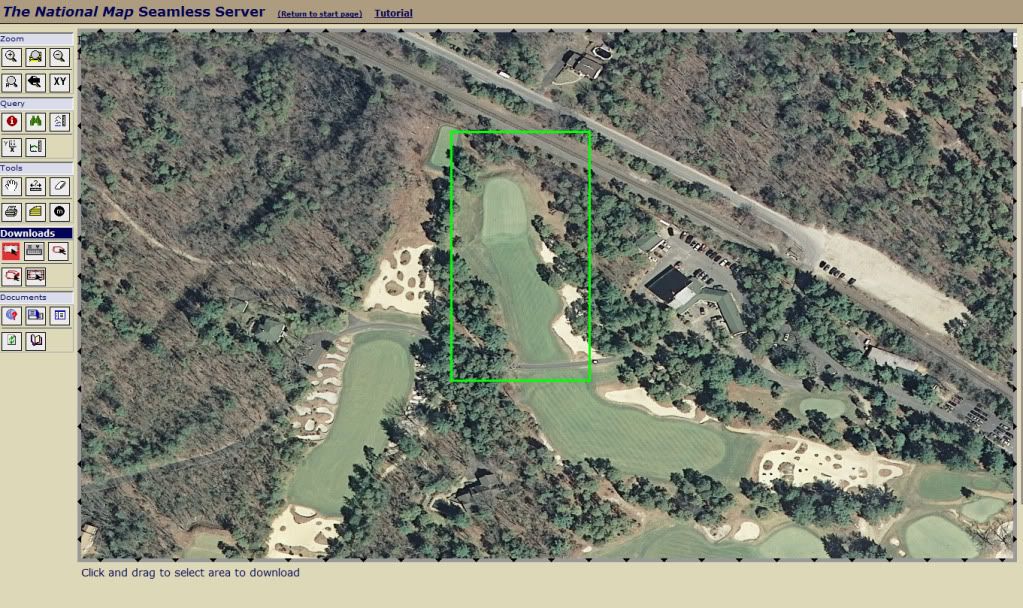


Of course, the downloaded file is not directly readable, but they do provide metadata for the file.

"Raster Download Information

Number of columns:  29
Number of rows:  51
Resolution in x direction:  3.08641999998043E-05 Degree
Resolution in y direction:  3.08642000000108E-05 Degree
Coordinate system ID Native:  4269
Top edge Native:  39.7930178265366 Degree
Bottom edge Native:  39.7914437523366 Degree
Left edge Native:  -74.9736742404835 Degree
Right edge Native:  -74.9727791786835 Degree

Coordinate system ID WGS84:  4326
Top edge WGS84:  39.7930178265366 Degree
Bottom edge WGS84:  39.7914437523366 Degree
Left edge WGS84:  -74.9736742404835 Degree
Right edge WGS84:  -74.9727791786835 Degree"

So, for my rectangle I've got 1479 data points with spacing of 3.0864E-05  degrees or about 11 feet.  So,it seems I've got 1/9 data.

 According to the USGS the 1/9 data generally has vertical accuracy of +/- 1 meter (3.3 feet).

"National Elevation Dataset (NED) 1/9 Arc Second (approx. 3m)

Resolution    1/9 arc-second (approx. 3m) Cont. U.S. - Where available (see The National Map Seamless Server for current coverage)
Projection    Geographic 
Horizontal Datum    NAD83
Vertical Datum    NAVD88 
Vertical Units    Meters
Vertical Accuracy    Generally +/- 1 meter (Depends greatly on the contract source)"

The horizontal and vertical datums are from 1983 and 1988 respectively.

So, what to do with the data.  Get a free trial copy of Global Mapper and see if I can use it to map the data and the contours.  Using Global Mapper and a custom shading profile, where I made all the elevations within a 5 foot band the same color, I get the following mapping for the downloaded rectangle.  The place where the color changes is, of course, the contour for that elevation.
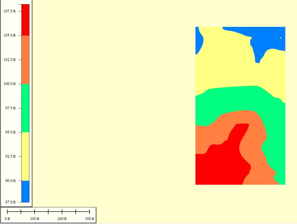


Now, overlaying that shading profile on a high resolution orthoimage of the 1st hole, I get the following map.
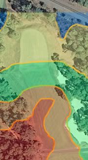


And from that I can trace the contour lines at 5 foot intervals.
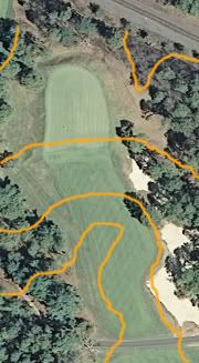


Now, one of the reasons I wanted to look at this area was because there is a nice picture of the first green at PV from Ran's write-up.  It was from the right side of the green and shows a sharp drop off of 6 or 8 or 10 feet (I'm sure the peanut gallery will provide precise estimates of the drop off).  Ran says it extends around three sides of the green.


Now, the data seems to have enough horizontal resolution (11 feet) and vertical accuracy (+/-3.3 feet) that the fall offs around the three sides of the green should be reflected in the 1/9 NED data.

But, they are not.  The data suggests the green runs away by 4 feet from front to back.  It doesn't look like it in the photo.

What is going on with the data?  It should have enough resolution and accuracy to show the features of the landform.

How can we trust it as an absolute benchmark to compare to the 1913 topo (forgetting for a moment that trying to validate two measurements of this sort over a century is unsound in the first place.

As to the absolute difference in elevations, we know that the benchmark elevation datum is 3 feet different in the two time periods.  We know that the 1/9 NED data has a +/-3.3 foot margin of error.  And, now, there is doubt in my mind that the data you purport to be precisely accurate can't discern elevation changes of 6 or 8 or 10 feet.  How can we place faith in your assertion that the 1913 foot topo is "off" or "wrong" based on your sample of half a dozen points that may not even be in exactly the same place?


JESII

  • Karma: +0/-0
Re: The Pine Valley Deeds
« Reply #248 on: December 02, 2011, 06:49:19 PM »
This stuff actually really interest me...maybe I should be over on the "you know you're a dork if..." thread but...The green does pitch clost to 4 feet from front to back, bt it's all the other elevations that exist in reality but not on that heat sensitive map that has me confused. Why doesn't it show the drop-off around three sides of the green? Why does it make it look like a 75 yard shot into the green is 10-15 feet downhill? It's about flat...

Jeff_Brauer

  • Karma: +0/-0
Re: The Pine Valley Deeds
« Reply #249 on: December 02, 2011, 07:00:52 PM »
Jim,

Any of those programs interpolates between whatever known points.  At a five foot contour interval, it spreads it out evenly, even though in this case, the green is flat, and then there are 4.5 quick feet of drop.  It doesn't show because its slightly less than the contour interval, and it doesn't show because of the smoothing effect of the contour mapping program.

Believe me, those programs need a lot of precise data at changes of steepness to get a contour map to read the way it is in reality.  Again, something a human can do holding a stick and surveying that the aerial and even LIDAR programs typically don't do.  They just aren't set up for the accuracy required for golf course design, or other design and engineering tasks.

Learned a lot about the newest version of the USGS maps here.
Jeff Brauer, ASGCA Director of Outreach

Tags:
Tags:

An Error Has Occurred!

Call to undefined function theme_linktree()
Back