News:

Welcome to the Golf Club Atlas Discussion Group!

Each user is approved by the Golf Club Atlas editorial staff. For any new inquiries, please contact us.


Bryan Izatt

  • Karma: +0/-0
Re: The Pine Valley Deeds
« Reply #200 on: November 28, 2011, 11:56:39 PM »
Here is the deed conveying property from Wilson et ux et al to Pine Valley in october 1916.


Bryan Izatt

  • Karma: +0/-0
Re: The Pine Valley Deeds
« Reply #201 on: November 28, 2011, 11:59:33 PM »


Here is the deed conveying a second tract from Virginia Ireland to Pine Valley, this one in February 1917.


David_Elvins

  • Karma: +0/-0
Re: The Pine Valley Deeds
« Reply #202 on: November 29, 2011, 12:40:06 AM »
On September 10, 1917 Pine Valley Golf Club bought a tract of land at the Southeast end of their core 184.31 acre property from Edward Y. Swope for $1.00 and other valuable considerations. 

Bryan

Any idea what the "other valuable considerations" that keep being referred to in the sale documents are? 

Crump seems to have aquired a lot of land without much cash.
Ask not what GolfClubAtlas can do for you; ask what you can do for GolfClubAtlas.

Bryan Izatt

  • Karma: +0/-0
Re: The Pine Valley Deeds
« Reply #203 on: November 29, 2011, 12:50:21 AM »

I am left wondering what Crump's comment on the map itself that the greens staked out on the ground didn't match those on the map.  I suspect that that means whoever transcribed the locations onto the map or vice versa had some difficulty placing where exactly the stakes were.  On the core property there were only the stones mentioned in the deeds.  I would guess that those were the starting point for the survey.  If the surveyor didn't plant additional markers/stones/stakes then it must be a real effort to know exactly where you are on an 184 acre property. 


"Am not sure the greens are marked on the map as I marked them on the ground."

This is GAC's comment on the map. It seems pretty straightforward, doesn't it?  Sure, the statement is straightforward.  What it means and what prompted him to write it is not so straightforward.  What is not known is when precisely he wrote it and who the comment was intended for. Was it intended for Colt who spent a week on site, or was it intended for one or more of the other seventeen men who originally were going to design one hole each, or was it intended for someone else.  All good questions.  Does the statement mean that he personally marked them out on the ground and then someone else marked them on the map?  Or is he chastising himself for not being sure he marked them on the map quite right?  Is this proof he routed the course on the ground first and not on the map first?  Others have suggested that the surveyor/mapper marked them on the map, but then why would he get the location wrong?  Pat's original contention was that Crump designed on paper because the land was too difficult, but this statement seems to suggest that he located (at least the greens) on the ground first.

Bryan
What is the purpose of this exercise/thread? Is there something you are trying to prove or discover?

The purpose of the thread was to get the PV deeds on the GCA.com public record for whatever insight they might provide to the readers here.

Do I have an agenda that I'm trying to prove?  No.  Am I trying to discover anything?  Sure.  Discovery sometimes occurs just by wandering about and questioning things.  Relative to the deeds we have discovered that PV didn't buy the land from Sumner Ireland as stated in the club histories nor did Crump inherit it from his father as Uzzell reported.  Are these as important "discoveries" as the Crump suicide or the date of Hugh Wilson's trip to GBI is in the minds of the readers.  I make no claim as to importance.  They are just more facts.


Bryan Izatt

  • Karma: +0/-0
Re: The Pine Valley Deeds
« Reply #204 on: November 29, 2011, 12:54:48 AM »
David E,

I don't know for sure what the valuable considerations were or why some deeds have them and others don't, but I suspect that they were mortgages of some sort.  It seems to have been standard practice of the day to do transactions for $1.00.  I don't believe for a second that that is actually what they paid.  Perhaps the rich folks of the day were just trying to maintain some financial privacy.

On September 10, 1917 Pine Valley Golf Club bought a tract of land at the Southeast end of their core 184.31 acre property from Edward Y. Swope for $1.00 and other valuable considerations. 

Bryan

Any idea what the "other valuable considerations" that keep being referred to in the sale documents are? 

Crump seems to have aquired a lot of land without much cash.

Bryan Izatt

  • Karma: +0/-0
Re: The Pine Valley Deeds
« Reply #205 on: November 29, 2011, 01:55:58 AM »
All I am using them for his the approx elevation of these two ridges.   Why shouldn't these topos be more than adequate for that? I thought you were doubtful because you didn't think there was enough clearance of the 4th ridge.

I am doubtful because the information I consider most reliable indicates that there is not nearly enough clearance of the 4th ridge, my doubt is based upon the apparent elevation of these two ridges.   Given that it is really not that close a call, surely the USGS map is accurate enough for this purpose.

OK, can you answer these questions so that I understand the geometry of your doubt.  Why don't you base it on a line of sight from the elbow of the 6th fairway across the middle of the 4th FW.

1   What elevation are you using for the camera (including the holder or tripod)?

2  What elevation are you using for the 4th FW ridge?

3   How far away is the 4th FW ridge?

4   How much is the camera above the 4th FW ridge line?

5  What is the elevation of the ground on the far ridge?

6   How far away is the far ridge?

7  How tall are the trees on the far ridge?

8   How many inches of the far ridge and trees are showing above the 4th FW ridge in the picture?

9   How many feet of the far ridge  and trees do you think that translates to?  What estimation technique did you use to make the translation?

10  Using simple geometry, how many feet down from level with the camera should you be able to see on the far ridge.

11  Is the top of the tree line on the far ridge above, level with or below the level of the camera?  If so, by how much?

12 Add or subtract 11 to or from 10

13  What is the discrepancy that you see between the answers to 10) and 12)
« Last Edit: November 29, 2011, 01:59:50 AM by Bryan Izatt »

Bryan Izatt

  • Karma: +0/-0
Re: The Pine Valley Deeds
« Reply #206 on: November 29, 2011, 02:05:28 AM »


David,

As an engineer by training I think I'd have to agree with Jeff that a 1913 surveyor was probably pretty accurate at that scale. 

I don't think that comparing a pre-construction topo to a topo from 100 years later post-construction is valid proof.

If the 1913 surveyor was uniformly out by 10 feet then why do the 140 foot contours to the right of the 6th fairway align so well?

I understand that your opinion is different.  Under the MacWood approach to historical research, we win 2 to 1.   ;D


Bryan Izatt

  • Karma: +0/-0
Re: The Pine Valley Deeds
« Reply #207 on: November 29, 2011, 02:12:49 AM »

David,

If you have the USGS National Elevation Data set (NED) at 1/9 arc second resolution created using (LIDAR) technology, then, of course, you will post the raw data or a topo based on it for PV, won't you?  And, the accuracy statement as well.

I will still be skeptical of its efficacy for validating a hundred year old site specific pre-construction topo, but it would be really interesting to see the data and to know how you mapped it.

Tom MacWood

  • Karma: +0/-0
Re: The Pine Valley Deeds
« Reply #208 on: November 29, 2011, 07:02:29 AM »

I am left wondering what Crump's comment on the map itself that the greens staked out on the ground didn't match those on the map.  I suspect that that means whoever transcribed the locations onto the map or vice versa had some difficulty placing where exactly the stakes were.  On the core property there were only the stones mentioned in the deeds.  I would guess that those were the starting point for the survey.  If the surveyor didn't plant additional markers/stones/stakes then it must be a real effort to know exactly where you are on an 184 acre property.  


"Am not sure the greens are marked on the map as I marked them on the ground."

This is GAC's comment on the map. It seems pretty straightforward, doesn't it?  Sure, the statement is straightforward.  What it means and what prompted him to write it is not so straightforward.  What is not known is when precisely he wrote it and who the comment was intended for. Was it intended for Colt who spent a week on site, or was it intended for one or more of the other seventeen men who originally were going to design one hole each, or was it intended for someone else.  All good questions.  Does the statement mean that he personally marked them out on the ground and then someone else marked them on the map?  Or is he chastising himself for not being sure he marked them on the map quite right?  Is this proof he routed the course on the ground first and not on the map first?  Others have suggested that the surveyor/mapper marked them on the map, but then why would he get the location wrong?  Pat's original contention was that Crump designed on paper because the land was too difficult, but this statement seems to suggest that he located (at least the greens) on the ground first.

Bryan
What is the purpose of this exercise/thread? Is there something you are trying to prove or discover?

The purpose of the thread was to get the PV deeds on the GCA.com public record for whatever insight they might provide to the readers here.

Do I have an agenda that I'm trying to prove?  No.  Am I trying to discover anything?  Sure.  Discovery sometimes occurs just by wandering about and questioning things.  Relative to the deeds we have discovered that PV didn't buy the land from Sumner Ireland as stated in the club histories nor did Crump inherit it from his father as Uzzell reported.  Are these as important "discoveries" as the Crump suicide or the date of Hugh Wilson's trip to GBI is in the minds of the readers.  I make no claim as to importance.  They are just more facts.


Bryan
There were numerous newspaper reports regarding the sale of the property. We have known of those reports for a long time and known Crump did not inherit the land from his father for a long time. No one thought Crump inherited the land from his father...at least no one familiar with the history of PV. The most interesting aspect of the Uzzell report is the hunting angle which is consistent with the many other accounts.

Perhaps I should have been more specific....I don't understand the purpose of this thread from a history of design point of view. I know golf architecture history is not something you are interest in, or at least have not shown an interest in the past, but is there some connection to design I'm missing on this thread? What do any of these deeds have to do with golf architecture...how do the deeds shed any light on how the golf course was designed or developed?

There are a lot of things we don't know about the Crump note. For example we have no idea what was on the map when he wrote the note. We don't know who the note was intended for....we don't know who was marking on the map when the note was made....we don't know who was marking on the map after the note was made...we don't know if the drawing on the map or the note on the map was pre-Colt or post-Colt. The map and note shed very little light on who designed the golf course.

JESII

  • Karma: +0/-0
Re: The Pine Valley Deeds
« Reply #209 on: November 29, 2011, 08:12:32 AM »

Bryan
There were numerous newspaper reports regarding the sale of the property. We have known of those reports for a long time and known Crump did not inherit the land from his father for a long time. No one thought Crump inherited the land from his father...at least no one familiar with the history of PV. The most interesting aspect of the Uzzell report is the hunting angle which is consistent with the many other accounts.


Tom,

This paragraph alone encapsulates the challenge of discussing these things with you...you agree Uzell didn't know what he was talking about regarding Crump owning the land for years but insist he had some unique insight into Crump hunting on the grounds.

Isn't it clear Uzell read somewhere else about Crump's hunting and threw in the rest for kicks? In fact, most of your 8 sources likely just read about the hunting on the grounds from someone else that's why it would be valuable for you to list the dates of the source references, but I won't expect that anytime...

As for you questioning Bryan's purpose...establishing the land acquisition timeline is pretty interesting to me and I'm sure others. That alone makes his efforts more than worthwhile.

JESII

  • Karma: +0/-0
Re: The Pine Valley Deeds
« Reply #210 on: November 29, 2011, 08:13:27 AM »
David,

Maybe it's happened elsewhere but I can't find it, can you post a clean version of the USGS topo you're using?

Thanks.

Jeff_Brauer

  • Karma: +0/-0
Re: The Pine Valley Deeds
« Reply #211 on: November 29, 2011, 08:25:12 AM »
Bryan,

Thanks for succinctly confirming my point.  If the current topo runs 10' lower than the pre-con topo, but is matching in other areas, that would suggest to me some earthmoving took place in building the golf course more than surveyor error.  Maybe that 180 contour around 6 green was really a knob or old sand pile (elevating the picture taker even higher) and was lowered to provide a run up green and the fill was used to level 6 fw or build 7 tee, or whatever?  

If ( BIG IF) confirmed, now how cool would that be?  That is the kind of stuff I am really interested in for these classics and if it came about from you starting a deeds thread, David questioning a photgraph and others chiming in little bits of knowledge from their expertise.  Messy, but a real coup for gca.com if it turns out that way.  

I know I am getting ahead of myself here, but it sort of answers TMac's question about the value of this - or any thread.  Their strength and weakness is exactly the same - you just never know where they are going to go!

PS - Oh yeah, if the current topo runs 10' higher than the old ones, my theory is that the LIDAR is really measuring the 10 foot of BullS**& that we dropped on PV via these threads! ;D
Jeff Brauer, ASGCA Director of Outreach

Tom MacWood

  • Karma: +0/-0
Re: The Pine Valley Deeds
« Reply #212 on: November 29, 2011, 09:20:05 AM »
Jim
I'm sorry you are frustrated. I'm not a lawyer...perhaps you look at these things differently, I don't know. As a historian I take Uzzell's report for what its worth, and I take it in combination with other information, and its not an all or nothing proposition. Tilly was wrong about Crump's death, but I don't disregard everything else he wrote about golf over the years. Clearly Uzzell was wrong about the inheritance of the property, but his hunting story is collaborated by numerous other sources. If he was the only source for the hunting story, then yes I would look upon it dubiously, but he is one of many. I try to weigh all the info.

PS: We have known about the sale of the property for over two years, at least. Numerous newspaper accounts have been posted about the sale. Was there someone out there who still thought Crump inherited the property?

JESII

  • Karma: +0/-0
Re: The Pine Valley Deeds
« Reply #213 on: November 29, 2011, 11:12:01 AM »
Tom,

Don't you agree that it's virtually certain that your hunting sources can all be traced to a single report and not from George Crump's mouth? Do you think Crump told Warner Shelly he had hunted on that specific property as a kid?

Bryan Izatt

  • Karma: +0/-0
Re: The Pine Valley Deeds
« Reply #214 on: November 29, 2011, 01:30:20 PM »
Tom,

Re you're comments:


Quote
Bryan

There were numerous newspaper reports regarding the sale of the property. We have known of those reports for a long time and known Crump did not inherit the land from his father for a long time. No one thought Crump inherited the land from his father...at least no one familiar with the history of PV. The most interesting aspect of the Uzzell report is the hunting angle which is consistent with the many other accounts.

I'm glad you've known for a long time.  I guess I was confused by your persistent use of Uzzell in support of the hunting story as an indication that you took the whole article at face value.  The PV historians believed for 97 years, more or less, that Crump didn't inherit it, but rather bought it from Sumner Ireland.  The other Tom now says that he and PV have known for three years that that was erroneous based on looking at the deeds.  Sometimes the old stories are just wrong.  If nothing else, I have convinced myself that the Sumner Ireland and the inheritance stories were wrong.  That you and others may have known that already is fine with me.

I don't understand your continued reliance on Uzzell to support the "hunting angle".  Uzzell says that Crump's father was a great huntsman (who knows); Crump's father bought it as a hunting preserve (wrong); Crump inherited it (wrong); Crump developed an interest in golf (after he inherited it?); and, Crump sensed the matchless appropriateness of the land for a golf course.  Where does it say he discovered the land while hunting?  It says he knew the land based on two erroneous presumptions.  A conclusion based on two false presumptions can't be taken as right by an historian, can it?

“Mr. Crump was the son of a British Consul to
this country who was a great huntsman and who
purchased the present property near the village of
Clementon, New Jersey, as a hunting preserve.
The son, inheriting the property, became interested
in golf and sensing the matchless appropriateness
of the land for a golf course devoted himself
wholeheartedly to producing the finest layout
money, devotion, and human ingenuity could
devise. He began the work in 1910 from his home
at Merchantsville near Philadelphia." 


Perhaps I should have been more specific....I don't understand the purpose of this thread from a history of design point of view. I know golf architecture history is not something you are interest in, or at least have not shown an interest in the past, but is there some connection to design I'm missing on this thread? What do any of these deeds have to do with golf architecture...how do the deeds shed any light on how the golf course was designed or developed?

Thanks for clarifying what your question was.  I'll answer it by asking you a question.  What did the Crump suicide story have to do with golf architecture or the history of design?  The deeds and Crump's death certificate, in my opinion, provide a context or color in more of the picture of what went on.  If they fall outside of your view of what this web site is about, then I guess you could just ignore them.

There are a lot of things we don't know about the Crump note. For example we have no idea what was on the map when he wrote the note. We don't know who the note was intended for....we don't know who was marking on the map when the note was made....we don't know who was marking on the map after the note was made...we don't know if the drawing on the map or the note on the map was pre-Colt or post-Colt. The map and note shed very little light on who designed the golf course.

Valid points.  So, are you suggesting that we trash the map because it doesn't directly answer these questions?  Or, should we continue to examine and question and dig and debate in the hopes that perhaps somebody else has known the answers for a long time and will tell us, or that new sources will be found, or that new analysis will answer some or all of these questions?

Bryan Izatt

  • Karma: +0/-0
Re: The Pine Valley Deeds
« Reply #215 on: November 29, 2011, 01:43:06 PM »
Jeff,

I think (until David disagrees) that we both agree that there was a knob/nose where the current 6th green sits, we're just debating how high it was in early 1913.  I can think of no logical conclusion that we can draw from the fact that there was a knob there then, and the green is relatively level now with excavated bunkers, other than that they did some cutting and excavation to create the green surface and the surrounding bunkering.  Of course, that doesn't answer the questions of who specifically did it or when it was done.  The question of who is probably unanswerable.  Even Doak apparently has trouble remembering all the details of who actually created the individual greens at Sebonack, and that was only a few years ago.


Bryan Izatt

  • Karma: +0/-0
Re: The Pine Valley Deeds
« Reply #216 on: November 29, 2011, 02:01:48 PM »
Jim
I'm sorry you are frustrated. I'm not a lawyer...perhaps you look at these things differently, I don't know. As a historian I take Uzzell's report for what its worth, and I take it in combination with other information, and its not an all or nothing proposition. Tilly was wrong about Crump's death, but I don't disregard everything else he wrote about golf over the years. Clearly Uzzell was wrong about the inheritance of the property, but his hunting story is collaborated by numerous other sources. If he was the only source for the hunting story, then yes I would look upon it dubiously, but he is one of many. I try to weigh all the info.

PS: We have known about the sale of the property for over two years, at least. Numerous newspaper accounts have been posted about the sale. Was there someone out there who still thought Crump inherited the property?


Tom,

As per my response to you above, where does Uzzell actually say that Crump discovered it while hunting?

You have consistently claimed 8 accounts.  Uzzell's is, at best, questionable.  Another says he was on horseback.  Shelley allows that it was possibly from the train.  Wind and Finegan are way after the fact.  Does it not seem possible, or even likely, that the hunting story is derivative of one source.  Several of us have asked you previously which "hunting story" was the first?  You haven't answered.  So, I'll ask again - which one was first?  Who reported it and what was their source?  Is it more contemporaneous and believable than Tillie?  For the record, I don't particularly care which turns out to be true or if they both have grains of truth in them, but I would like to draw my own conclusions as best I can rather than rely on the opinions of others.

Re the PS above.  Tom Paul is claiming to have known for 3 years about the deeds and sale.  Are you two in a race about who knew first?

DMoriarty

  • Karma: +0/-0
Re: The Pine Valley Deeds
« Reply #217 on: November 29, 2011, 03:00:36 PM »

David,

If you have the USGS National Elevation Data set (NED) at 1/9 arc second resolution created using (LIDAR) technology, then, of course, you will post the raw data or a topo based on it for PV, won't you?  And, the accuracy statement as well.

Sure Bryan, right after you post the same information establishing the accuracy of that 1913 topo.  

No, wait . . .   you can't.   You don't have the data used to make that topo.  You don't know the grid spacing. You don't know the basis information from which they determined their starting point. You don't know the extent to which sketching, eyeballing, and estimation were used.  You don't have any sort of "accuracy statement" because they didn't provide one.

Why should I be the only one required to provide any specific FACTUAL basis for my conclusions?  You guys are claiming the elevations on your 1913 topo are accurate.  Prove it.  

It is the same thing over and over again on this website.  Blind speculation by self-proclaimed experts is propped up as if it trumps actual facts.  It doesn't.  

Quote
I will still be skeptical of its efficacy for validating a hundred year old site specific pre-construction topo, but it would be really interesting to see the data and to know how you mapped it.

So you expect me to jump through these hoops for you even though you've already made up your mind?  No thanks.
« Last Edit: November 29, 2011, 03:25:16 PM by DMoriarty »
Golf history can be quite interesting if you just let your favorite legends go and allow the truth to take you where it will.
--Tom MacWood (1958-2012)

Bryan Izatt

  • Karma: +0/-0
Re: The Pine Valley Deeds
« Reply #218 on: November 29, 2011, 03:34:14 PM »
David,

OK, forget the accuracy statement for the USGS NED set.  I'm sure I can find it.  And, I'm not really questioning its accuracy, I'm sure it is pretty good or at least better than the previous USGS maps.

Could you at least confirm that you've been using the 1/9 arc second resolution NED data throughout this discussion or not.  The maps you've posted have been from the NJ State Atlas and that as far as I know isn't at 1/9 arc second resolution.

From a brief look at the NED 1/9 arc second site, I was prepared to be impressed that you could find a way to map it, or that you'd found a site where someone else had done it for the PV area.  It might have been useful for future investigations.

No, I can't "prove" the 1913 topo is accurate as to elevations.  On the other hand, you can't "prove" that the current elevations should be exactly the same as the 1913 elevations.  I think that comparing two sets of elevations one hundred years apart with construction in between is not logically correct.  Instead of getting in a knot, why don't we keep exploring it?  Maybe there is a way that we can divine that will satisfy both of us.

The 13 question geometry exercise is still out there.  I am prepared to consider your analysis.  Maybe you are right.  But, I can't really say without you putting some metric on what you think you are seeing.

I'm sorry you you feel such antipathy to this site and its participants.  Why do you stay on?


DMoriarty

  • Karma: +0/-0
Re: The Pine Valley Deeds
« Reply #219 on: November 29, 2011, 03:49:35 PM »
David,

Maybe it's happened elsewhere but I can't find it, can you post a clean version of the USGS topo you're using?

Thanks.

I had been using the USGS quad topo, a excerpt of which I think I most recently posted in post 181.  I am also using data from the USGA's NED 1/9 Arc Second database.   "1/9 Arc Second" means that they collect elevation data in a grid with a unique data point every three meters. According to the USGA the accuracy is generally +/- one meter.  

The USGS NED 1/9 Arc Second data is not very close to the  1913 topo.   A few examples examples,
-- The 1913 topo has the first green at between 105 and 110 feet, while the 1/9 NED data has it at around 94 ft.
-- The 1913 topo has the third green at around 135 ft, while the 1/9 NED data has it at around 124 ft.  
-- The 1913 topo has the sixth green at around 180 feet, while the 1/9 NED data has it at around 166 ft.  
-- The 1913 topo has the fourth green at between 115 and 120 feet, while the 1/9 NED data has it at around 111 ft.  
-- The 1913 topo has the eighteenth green at around 110 feet, while the 1/9 NED data has it at around 101 ft.

IN fact, I can't find any elevations that are even close to a match.  Most are around 10 feet off, or more.  
Golf history can be quite interesting if you just let your favorite legends go and allow the truth to take you where it will.
--Tom MacWood (1958-2012)

DMoriarty

  • Karma: +0/-0
Re: The Pine Valley Deeds
« Reply #220 on: November 29, 2011, 04:09:27 PM »
Bryan,

I have not been using the 1/9 NED data this entire conversation. I have been using the quads.  I dug up the 1/9 NED data because, incredibly, the quads aren't good enough for you.   Now that you've indicated the 1/9 Arc Second data is probably not good enough for you either, we've got nowhere to go.  If I reinvented the USGS wheel and commissioned my own LIDAR aerial survey to get the accuracy down to a few dozen centimeters (possible with LIDAR technology) I sincerely doubt that'd be good enough you either.  

But your methodology is flawed.  You guys have no FACTUAL basis for proclaiming that old 1913 top to be accurate, especially when all FACTUAL indications are that it is NOT.   You are requiring unbelievably accurate information from me to refute it, yet you have ZERO information regarding its accuracy in the first place.    It is the Merion debate all over again.  There is little or no FACTUAL BASIS for the conventional theories, yet I am required to disprove them to an absolute certainty.   This isn't science with you guys, it is religion.  

I disagree with you about comparing the data set now with the topo then.  Sure we cannot micro compare, but the numbers on the 1913 topo are not even close, and they are off across the board, both on the golf holes and off.   The earth hasn't shifted that much.

I feel no antithapy to the site and no antipathy to anyone else currently participating except for Brauer, and he knows damn well the basis and I am more than justified.  Had he half a brain he'd stay the hell away from me.  

The information comes from National Map Seamless Server.   http://seamless.usgs.gov/website/seamless/viewer.htm

I am still navigating my way around the server, and not sure about a few things and trying to figure them out, but I can tell enough from the information that is there that the elevations not that old topo are off across the board, and not by one or two feet.  

That said, here is a cross section from which you can derive your answers. Put the tripod high as you think reasonable.   It is compiled from 200 readings along that line, using the rasterized 1/9 NED database.  Consider it tentative though as I am still trying to resolve a few things.
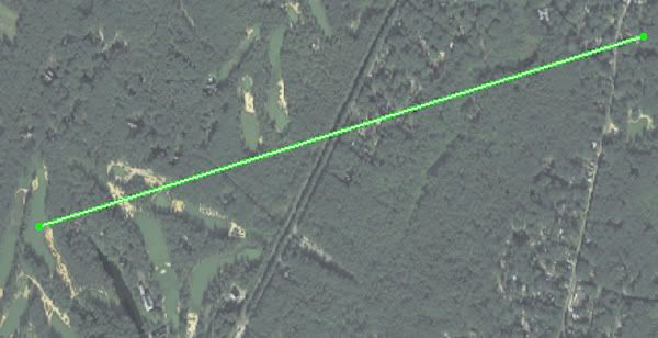

« Last Edit: November 29, 2011, 04:33:53 PM by DMoriarty »
Golf history can be quite interesting if you just let your favorite legends go and allow the truth to take you where it will.
--Tom MacWood (1958-2012)

Bryan Izatt

  • Karma: +0/-0
Re: The Pine Valley Deeds
« Reply #221 on: November 29, 2011, 05:26:14 PM »
I'll look when I get home. The Blackberry is useless for this.

Are the individual points different consistently in one direction?  Are the contours the same, but the elevations just consistently different?  If they were, that would indicate a basis point difference.  If there are random differences then there must be some other explanation.

DMoriarty

  • Karma: +0/-0
Re: The Pine Valley Deeds
« Reply #222 on: November 29, 2011, 06:31:53 PM »
The points are all off in the same direction.  See post to Jim above.  As I have said repeatedly, the shapes seems to be generally the same, although it is tough to tell with that distorted image.  It is the absolute numbers that are off.
« Last Edit: November 29, 2011, 06:36:57 PM by DMoriarty »
Golf history can be quite interesting if you just let your favorite legends go and allow the truth to take you where it will.
--Tom MacWood (1958-2012)

Bryan Izatt

  • Karma: +0/-0
Re: The Pine Valley Deeds
« Reply #223 on: November 30, 2011, 01:43:19 AM »
David,

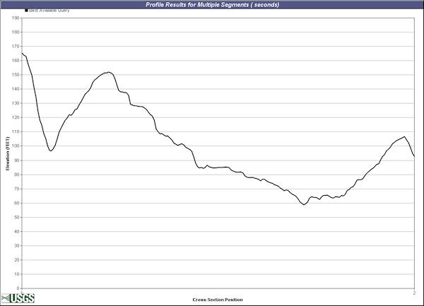
I need to look into the LIDAR more, but in terms of the two graphics below, I agree that there would be little or none of the far ridge showing along that axis.  That axis is more along the line Patrick was pushing.  I always thought that that angle was wrong precisely because the far ridge wouldn't be visible over there.  I have thought for a while that the angle of view was entirely to the right of there.  I think the 2nd green and 3rd tee is just outside the left side of the picture.  Run a line from your starting point and through the middle (side to side perpendicular to the 2nd green) or the right side of the 4th fairway  and see what that looks like. As I understand it, you think the caption is totally wrong and the picture is from somewhere else on the course.  I think it is only partially wrong;  I think it's from the 6th fairway overlooking the 4th fairway, but not the 2nd green and 3rd tee.

I was looking at three USGS quad maps based on surveys done in 1885, 1953 and 2001.  There was a benchmark datum point at the top of Pine Hill.  In 1885 it was 202 feet.  In 1953 it was 199 feet.  In 2001 it was on the upside of a 190 foot contour and there was no 200 foot contour.  So, it is probable that the benchmark location elevation has been changed by the USGS over the years.  If the starting benchmark was higher in 1913 than it is on the current topos, then of course everything on the 1913 topo would be too high compared to the current elevations.  Question then goes back to the contours.  Do they look the same or are they materially different.  Are the difference the result of surveying error or grading changes?

As for the 'what can you see over the 4th FW ridge' try a couple of lines further to the right.  Let's do a comparison based on the 1913 topo and the LIDAR data.  For that exercise, the absolute values don't matter.  The elevation differences within the same topo do.


..............................

That said, here is a cross section from which you can derive your answers. Put the tripod high as you think reasonable.   It is compiled from 200 readings along that line, using the rasterized 1/9 NED database.  Consider it tentative though as I am still trying to resolve a few things.


Bryan Izatt

  • Karma: +0/-0
Re: The Pine Valley Deeds
« Reply #224 on: November 30, 2011, 03:57:09 AM »
Looked at the National Map seamless Server.  Things that struck me:

The RR and the Road overlays are substantially off.

The NAIP aerial overlay looks closer, but does it overlay perfectly?  Hard to say.

There doesn't appear to be a way to generate contours, so comparing contours to the 1913 topo doesn't seem possible.

The elevation profile tool doesn't offer a 1/9 arc second option except for Puget Sound; what is the "best available" data set they use with this tool around PV?


Tags:
Tags:

An Error Has Occurred!

Call to undefined function theme_linktree()
Back