I've tried to overlay both the 1898 topo and the modern NJ Atlas topo. I don't think it can effectively be done, but why don't you give it a try. I'd say based on eyeballing it that the 1898 topo doesn't match at all well. The modern topo is not too far off, but it's difficult to say because of the distortion of the 1913 topo I cleaned up.
Bryan, I haven't tried nor do I care to. I trust you when you say it can't effectively be done. Nonetheless we can read the respective tops without doing a precise overlay.
I am confused as to how you can say the modern topo is not far off from the Crump topo. Here is an overlay of the course and the USGS topo, from the NJ Aerials website. As you can see the highpoint of the 6th fairway is 164 ft, which is about what Google Earth comes up with, and the green is at 170+ which again is what Google Earth comes up with. In contrast, your cleaned-up Crump topo has the entire fairway at over 170 ft, portions at 175+, and the green at 180+. Not all that close as topos go.
As for the creek vs. the pond issue, if the pond is shown on a topo dated March of 1913, I am inclined to think there was a pond there then, despite what Tillinghast might have called it. Who knows, maybe Tillinghast thought the hole would cross below the dam?
The 1898 topo shows a creek. The 1913 topo shows a creek at the top end, presumably from the springs. If they had converted the creek to a pond by March 1913, when would they have done that? Between November and March? How would they have done it? Just throw up a dam and wait for it to fill up? Excavate the bottom to create the pond? Maybe we could get Pat and Tom out there in a canoe and plumb the bottom to see how deep it is. Would they have had to line the bottom with clay. Why wouldn't the water just percolate through the underlying sand and the pond not fill up? I fail to see how all that engineering work could be done in 4 months over the winter. Rather than considering Tillinghast to always be wrong, why don't we assume that he knew the difference between a pond and a creek.
Not sure why you are trying to make this about Tillinghast? I've no interest in maligning Tillinghast or anyone else, so let's not pretend otherwise. It looks to me like the creator of the map drew in a pond and and marked it "Pond," and drew a dam and marked it "Dam." Am I misreading that? Do you think the pond was drawn later? If so, how did you reach that conclusion? If not, do you think the map maker was hired to do a topo but thought he'd throw in a post construction rendering of a pond? That'd be a bit strange, don't you think? Did they tell him to add in a model for the pond, but nothing else-- not tees, greens, or even roads? Is it possible that there was some semblance of a pond there, even a seasonal pond, and they added to it later?
If there was some semblance of a pond, it could have been created anytime after the 1880's survey took place.
Now you're being silly. What does the timeline of a state level survey and the publication of state contour maps have to do with this situation. Crump bought the land in the fall. Presumably he commissioned the surveyor shortly thereafter. Why would there be any significant delay in delivering the map. Presumably Crump wanted the map and the surveyor wanted to get paid.
Again, Bryan no need to get snippy. I don't doubt that Crump had the map in March. My point was that the date on the map doesn't necessarily reflect the date of the survey. Do we know that Crump commissioned an actual original survey? I don't recall. If we do not know, then it raises the possibility that that map was created using prior survey data, date unknown.
__________________________________________________
Jim,
I don't see the same things in those old pics as you do. For example, I don't see anything that looks like "falling off a mountain" like you see in the Brown pic, and while I understand what you mean about a "wall" from the photos of the hole, I don't see anything like that in the pic with the man.
I really don't know what else to say about it except that I am not convinced and I don't think the geometry makes any sense at all. Probably I am wrong --I have never been there so what the hell do I know? But with what little I know, I cannot make sense out of either caption.
As for the article you posted, how does it address the timing of the creation of the pond? Is it possible there was some semblance of a pond or swamp there, and it was expanded during construction?
_____________________________________________________
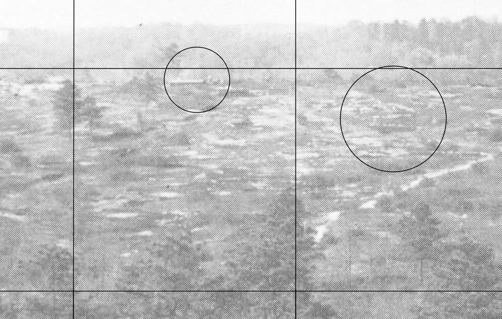
I mentioned that there was quite a bit in the blowup, ranging from interesting to strange. Here is a section with a bit of both. In the first circle there appears to be a low structure with possibly some other structure (tanks or something) behind next to it, or behind. There appear to be some dunes, mounds, or piles around these structures. I have no idea what to make of what looks to be in the second circle. I also see a few more roads or trails, including a fairly large one running at a diagonal, touching the bottom of the first circle. I also see what may be another structure in between the circles but I am not sure.
