News:

This discussion group is best enjoyed using Google Chrome, Firefox or Safari.


DMoriarty

  • Karma: +0/-0
Re: Pine Valley and Topos
« Reply #575 on: September 01, 2011, 04:56:52 PM »
Of course he did, after the holes had been found and land had been surveyed.   Are you really this dense, or are you playing games?
Golf history can be quite interesting if you just let your favorite legends go and allow the truth to take you where it will.
--Tom MacWood (1958-2012)

DMoriarty

  • Karma: +0/-0
Re: Pine Valley and Topos
« Reply #576 on: September 01, 2011, 05:52:31 PM »
I've taken a closer look at some old posts, and as usual, Cirba's own evidence cuts directly against him.   George Bahto's excellent book contains an image of an early blueprint containing the rough plan of NGLA, and on the plan there are centerline hashmarks along the holes.  While it is impossible to make them out in the image, George has represented that they are elevations.  

If so, this is strong indication that the initial survey occurred after the rough routing had been determined:  
- Had Raynor's contour map been created before the course was roughly routed, then one would expect the routing to have been done on the contour map.
- The early blueprint is NOT A CONTOUR MAP.  Rather it is a survey of the elevations along THE CENTERLINE OF THE GOLF HOLES.
- To conduct a survey along the centerline of the golf holes, one must first have located the golf holes!  
- Had the centerline not already been determined, how would Raynor (or whoever) have known where to conduct his centerline survey?  

As CBM wrote in Scotland's Gift, Raynor was first hired to survey the property. This early plan with the property borders and the major water features and the centerline elevations may well have been his initial survey.  (Other reports confirm that the centerline elevations had been determined by sometime in 1907, which judging from the name on the map ("National Golf Course of America") is probably the approx. date of this blueprint.)  Whatever contour map was created must have come after and been used for construction and/or the creation of the plasticine models.

This ought to put Cirba's inane theory to rest once and for all.  His own evidence (which he misrepresented as a "contour map") cuts directly against him. But this won't stop Mike, for he is the Energizer Bunny of foolishness.  No matter how wrong, he just keeps going.  

But I am done with him.
« Last Edit: September 01, 2011, 05:54:21 PM by DMoriarty »
Golf history can be quite interesting if you just let your favorite legends go and allow the truth to take you where it will.
--Tom MacWood (1958-2012)

Mike Cirba

Re: Pine Valley and Topos
« Reply #577 on: September 01, 2011, 06:00:39 PM »
David,

Perhaps you can educate us all as to how Raynor's survey of the Sebonac Neck property was such a useful tool in locating intended template holes on the existing native, untouched terrain?

DMoriarty

  • Karma: +0/-0
Re: Pine Valley and Topos
« Reply #578 on: September 01, 2011, 06:22:16 PM »
David,

Perhaps you can educate us all as to how Raynor's survey of the Sebonac Neck property was such a useful tool in locating intended template holes on the existing native, untouched terrain?

My goodness, you really aren't faking it, are you?  I'll try to type slowly so you can try to follow along.  

The survey was NOT a useful tool in locating the intended template holes, BECAUSE CBM and HJW HAD ALREADY LOCATED THE HOLES BEFORE the survey was conducted. The blueprint in question has survey information at points along the centerline of the golf holes.  More specifically, according to George Bahto, the blueprint has surveyed information (elevations) directly between the marked tees and greens.  One cannot conduct such a survey between tees and greens without first locating the tees and greens.  One cannot conduct survey of elevations along the routing without first determining the routing.

First the holes, including the locations of the tees and greens, were located.  Then a survey was conducted in a direct line between the tees and greens.  


« Last Edit: September 01, 2011, 06:25:24 PM by DMoriarty »
Golf history can be quite interesting if you just let your favorite legends go and allow the truth to take you where it will.
--Tom MacWood (1958-2012)

DMoriarty

  • Karma: +0/-0
Re: Pine Valley and Topos
« Reply #579 on: September 01, 2011, 06:52:05 PM »
While we are waiting to see how Cirba will try to slither out of this one, perhaps we can return to Pine Valley and the issue of the early use of contour maps.   Frankly, I don't understand what you guys are trying to prove.   It is very unlikely that Pine Valley was the first to use contour maps.  

I believe that Joe Bausch has an article indicating that a pre-construction contour map was created at Princeton for Willie Dunn in the late 1890's  In addition I believe Dunn most likely used pre-construction contour maps at Ardsley Park, which was a huge engineering project, and at the additions and changes to Le Phare (Biarritz) in the early 1890's, as well as for the expansion of Shinnecock to 12 holes in 1893.    Others have produced very early contour maps containing golf course plans, but it is impossible to tell whether the contour was created before or after the course was planned. If I recall correctly one of the Colt guys (I don't remember which one) noted that Colt used some sort of detailed relief map pre-construction at Toronto in 1911.

Is the distinction whether or not contours were used in the initial routing?  If so, that would seem to be very difficult to establish except perhaps in the case of Ross, where plans were drawn on contour maps without the gca ever having visited the land.

What is the significance of this "conversation," if any?
Golf history can be quite interesting if you just let your favorite legends go and allow the truth to take you where it will.
--Tom MacWood (1958-2012)

Patrick_Mucci

Re: Pine Valley and Topos
« Reply #580 on: September 01, 2011, 08:49:39 PM »
David,

Mike clearly chooses to ignore the chronological order of events in order to suit his agenda,
What I find distasteful is his deliberate distortion of the truth.
Yet, that seems to be a common theme in his presentations.

As to PV and contours, neither TEPaul or myself ever stated that PV was the first to employ them, only that PV appears to be amongst the first to employ them.

Here's the 1898 topo


And, the zoomed in version.


The Blue/Red schematic which appears to have topo lines.
Off the top of my head, I can't recall seeing an early course routing superimposed on a topo


The environment and land at PV appeared to be hostile with steep inclines, swamps and dense forest covered in jungle like scrub.

I know that GAC took what seemed like an inordinate amount of time to craft the routing and hole designs, but, despite the time on site, it would appear that topos would provide more information than field study, from a hole design perspective.

DMoriarty

  • Karma: +0/-0
Re: Pine Valley and Topos
« Reply #581 on: September 01, 2011, 11:29:16 PM »
David,

Mike clearly chooses to ignore the chronological order of events in order to suit his agenda,
What I find distasteful is his deliberate distortion of the truth.
Yet, that seems to be a common theme in his presentations.

I agree that these guys let their desired outcomes shape their understanding of the evidence, and not visa versa.  As we have seen multiple times before, Mike would rather completely reverse himself on "the facts" than face the real fact that his conclusions are wrong.  No doubt he will pull this same crap again here.  He went from responding to my posts in a matter of minutes to radio silence after my last post spelling it out for him.  This means he knows I am correct, or at least he has a good idea that I am.  Yet rather than admit it and let the conversation progress, he is trying to regroup and come up with something - anything - to keep alive his bogus theory.  Meanwhile, his tail is between his legs and, like any good lap dog, he is probably awaiting his master's next command.

Quote
As to PV and contours, neither TEPaul or myself ever stated that PV was the first to employ them, only that PV appears to be amongst the first to employ them.

I guess that depends upon what you mean by "amongst the first."  If Willie Dunn was using contour maps in the mid-1890's, then their use dates back to some of the earliest courses in this country.    I guess if we look at the entire history of GCA in America, then PV was amongst the first, but I doubt the use was all that groundbreaking if we look close up.  

That said, I agree that contour maps were probably pretty important at PV, especially given that the person usually credited with designing the course (for the first few decades at least) was overseas during most of its construction.

Quote
Off the top of my head, I can't recall seeing an early course routing superimposed on a topo

That may be because we don't have too many examples where we would be able to tell one way or another whether the contour map came before the plan.  

There are actually other course routings on contour maps, but normally we have copies of them and/or they are all drawn in the same ink, so it is impossible to tell for sure whether the contour was used in the planning and/or construction.   TEPaul's position on this has been predictable --he assumes that if there is no absolute proof  of an example that the contour came before the plan, then we must assume it never happened that way.  That of course is flawed and self-serving logic at best.

There are enough examples of courses with contour maps that I suspect that the practice was not all that uncommon from the beginning of golf architecture in America.  In other words, rather than being first, Pine Valley may just be the rare example where we have enough information to make the determination with anything resembling certainty. Normally we don't have information (such as different color pens) allowing us to make that determination. For example, here is an example of a Kent, Michigan course from 1901, posted earlier this year by Neil Regan:


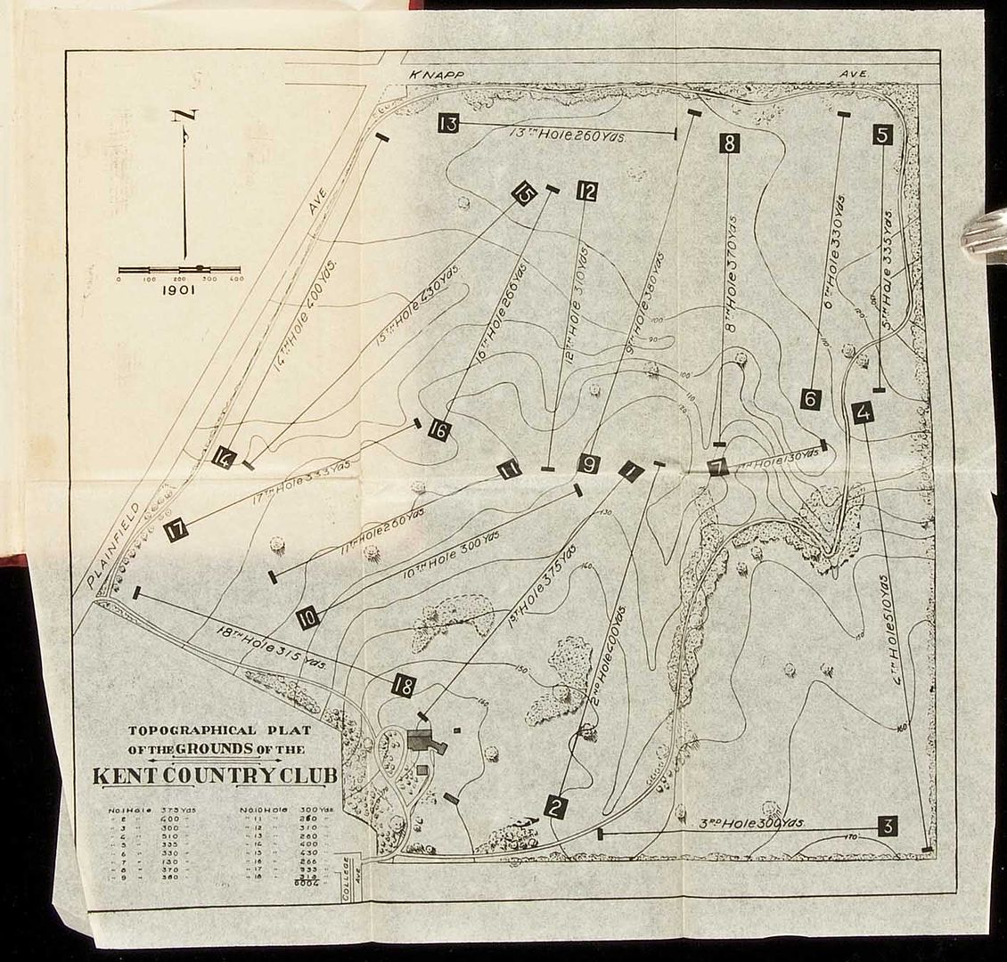
As you can see, it is a contour map with holes shown, but it is impossible to say from this alone whether the contour map was created after the course, or whether the course was drawn on the contour map at some point in the planning. We don't always have the advantage of a different color inks or of apparent changes made right on the map, suggesting some sort of design progression.  But there are enough of such maps that we at least need to consider it a very good possibility that contour maps were being used.

Likewise, in the past I have posted a couple of very early plans by Dunn (or at least I think they are by Dunn) which similarly show contour lines.  We cannot say for certain that he used the contour maps as part of the planning and/or construction on these courses, but given the article Joe found stating that this was his procedure at Princeton, and given the engineering demands of some of his early projects, it seems a pretty fair assumption that he used contour maps as part of his planning and construction process.
« Last Edit: September 01, 2011, 11:46:26 PM by DMoriarty »
Golf history can be quite interesting if you just let your favorite legends go and allow the truth to take you where it will.
--Tom MacWood (1958-2012)

Bryan Izatt

  • Karma: +0/-0
Re: Pine Valley and Topos
« Reply #582 on: September 02, 2011, 03:46:23 AM »


Patrick,

Quote
I know that GAC took what seemed like an inordinate amount of time to craft the routing and hole designs, but, despite the time on site, it would appear that topos would provide more information than field study, from a hole design perspective.

Could you elaborate on why you think the topo would have provided more information than field study from a hole design perspective.  The topo is a two dimensional simplification of reality.  It would seem to me that field study would provide a much more informative three dimensional view of the land.

In the early days you seem to feel that GAC wouldn't have been able to gather much information from field study due to the density of the forest and underbrush.  How do you suppose that the USGS created the contour map in 1898 in that dense forest and underbrush?


JESII

  • Karma: +0/-0
Re: Pine Valley and Topos
« Reply #583 on: September 02, 2011, 09:00:39 AM »
Let's drop the Merion and NGLA sidebars and see if we can move this conversation in the direction Pat originally intended..."how much of the creative process was in the field as opposed to in an office looking at a map?".


I have no idea when Crump actually moved onto the property, or how much time he spent on the project in that first winter of 1912 into 1913 but it's tough for me to imagine the initial work was done much on paper at all. A novice would have look at the landscape in person wouldn't he?

Mike Cirba

Re: Pine Valley and Topos
« Reply #584 on: September 02, 2011, 09:21:25 AM »
Jim,

Are you going to let the self-ordained site bullies tell you which of the other kids you can talk with?    :-X

I think there are interesting parallels and differences between all three early development efforts and I'm going to continue to compare and contrast.   Besides, Patrick doesn't really want to talk about the topos at PV anyway...first, he knows next to nothing about them and he's simply trying to imply that Harry Colt designed the course by creating doubt about who did what on paper and the timing of it.   He's also basically doing it to piss off Tom Paul, as seemingly David is as well, who can't get through two paragraphs without once again sharing his man-crush and obsession with Tom with us yet again.

I'd contend that if that's what Patrick really wanted to talk about he would have done so...instead, he's focused on trees and trains no matter how many times I've asked him to engage on topos, simply because he has nothing else.

What we do know about the timing of things at PV is this;

In January of 1913, after getting permission from Crump to tell the story, Tillinghast told us that charting the ground topographically was a future event.

The topo map and proposed routing drawn atop it known as the "stick drawing" was in Crump's hand.   Paul Turner agrees with that, but notes that there is also some other handwriting on it, possibly/probably indicating that Crump shared his initial plans with Colt upon his visit late May/early June of 1913.

A copy of the same underlying contour map was provided and at some point either Harry Colt drew up his proposed plan on it (or Crump had Colt's individual hole drawings copied atop it), with a number of holes based on Crump's original, and a number of Colt's holes later modified or wholly changed, particularly on holes 2, 7, 12, 13, 14, 15....holes 1 through 4 and 18 were essentially the same as what Crump originally drew.

Then, there is the blue/red map, with the red pen seemingly writing over Colt's blue lines...Paul Turner, if he's still tuning in on this painful insult-athon, may have a different perspective and opinion, which I'd enjoy hearing.

I don't pretend to know all of the details, but I do know what's complete BS, and total conjecture, misrepresentation of facts, and strained speculation going on here in supposed search for "the real story".   And that's what 95% of this thread has been to date.


« Last Edit: September 02, 2011, 12:14:36 PM by MCirba »

Mike Cirba

Re: Pine Valley and Topos
« Reply #585 on: September 02, 2011, 09:30:16 AM »
Patrick,

I would agree with David that this is clearly not the first time we've seen the drawing of a golf course superimposed on a routing map and also agree with him that Seymour Dunn did them, even next door to NGLA at Shinnecock back in the 1890s.   

I think if you spend more time reading and researching and less time trying to come across as having discovered the wheel each time a new thought occurs to you we'd all be better off.   

But, this really isn't about the evolution of topos at Pine Valley or what they were used for, or their place in history at all, is it?

Otherwise, we'd be much further along in the discussion instead of lost in the woods.

Mike Cirba

Re: Pine Valley and Topos
« Reply #586 on: September 02, 2011, 09:46:28 AM »
Dear David,

I know you miss me, my darling.   But, we do live on different coasts, and sadly, I'm not always able to converse with you when you suddenly decide to join the discussion on page 17.

Plus, although it breaks my heart, we do live in different time zones three hours away and sometimes when you're ready to engage with me, it may be my dinner time, or visa versa.   Particularly saddening is that in the late of the evening, often I have to go to sleep while you're still ready to play.

You know, I've been told that these long-distance relationships never work out anyhow, but I so wanted that to be a "myth".   Instead, I'm sensing that something's wrong, dear.

In the words of Carole King, you look so unhappy and I feel like a fool.  In fact, in yet another pique of rage yesterday, you did call me that, among other not-so-nice things.    

Still, I cling to the probably mistaken notion that we share more things in common than drive us apart.   Thus, I will try to continue and I do hope you can find the strength and courage to just end things if it isn't working for you.    I know you miss me, but all of that venom that continually spews out of you can't be good for you and it worries me so.

Perhaps we can try couples therapy?   :-\

« Last Edit: September 02, 2011, 12:27:10 PM by MCirba »

Mike Cirba

Re: Pine Valley and Topos
« Reply #587 on: September 02, 2011, 11:03:04 AM »
David,

Rather than "slinking away", or awaiting "further orders" from my commandant, please instead see my comments in reply to your latest angry post below in Blue


I've taken a closer look at some old posts, and as usual, Cirba's own evidence cuts directly against him.   George Bahto's excellent book contains an image of an early blueprint containing the rough plan of NGLA, and on the plan there are centerline hashmarks along the holes.  While it is impossible to make them out in the image, George has represented that they are elevations.   

If so, this is strong indication that the initial survey occurred after the rough routing had been determined: 
- Had Raynor's contour map been created before the course was roughly routed, then one would expect the routing to have been done on the contour map.


That's an interesting leap.   Because a blueprint map that CBM apparently used to play around with location of his bunkers and other man-made features over time (ask George if you don't believe me) has center line elevations every 25 yards, it therefore follows that the routing of the course had to precede the creation of the "contour map" of the property CBM told us he asked Raynor to create??  ::)

It seems to me that insertion of elevation numbers down the center lines of each hole would be very valuable for the purpose of locating bunkers...not sure what else...


- The early blueprint is NOT A CONTOUR MAP.  Rather it is a survey of the elevations along THE CENTERLINE OF THE GOLF HOLES.
- To conduct a survey along the centerline of the golf holes, one must first have located the golf holes! 
- Had the centerline not already been determined, how would Raynor (or whoever) have known where to conduct his centerline survey?


I completely agree with you and you're simply stating the obvious.   In fact, not only is that blueprint map not a contour map, it strongly suggests that the contour map was created prior to this map.   Unless you're trying to tell us that Raynor first surveyed the property of Sebonac Neck (which CBM tells had never been surveyed prior), then was asked back by CBM to walk single file down each of CBM's holes and shoot elevation points every 25 yards, and then was asked back again to create a contour map of the entire property, then where would these elevation points on the blueprint have come from?   This is not the sequence of events that CBM describes in his book, is it?

By the way, you told us that CBM could have used Raynor's property "survey" to route the holes?   I've asked before, I'll ask again...what would be the value of trying to plot three-dimensional template holes reliant on natural features on a flat property map that simply showed the dimensions, metes and bounds, and any building locations on the property?


As CBM wrote in Scotland's Gift, Raynor was first hired to survey the property. This early plan with the property borders and the major water features and the centerline elevations may well have been his initial survey.  (Other reports confirm that the centerline elevations had been determined by sometime in 1907, which judging from the name on the map ("National Golf Course of America") is probably the approx. date of this blueprint.)  Whatever contour map was created must have come after and been used for construction and/or the creation of the plasticine models.

David, do you know what a property survey is?   Seriously.   Because if the Sebonac Neck property had never been surveyed prior, which CBM told us, it was very likely needed for any real-estate transaction agreement to have taken place, which you tell us took place sometime between October and December 1906.   Remember that the land of Sebonac Neck was never sold previously as a separate parcel, but as part of a coupla-thousand acres transaction, most recently to Alvord.

A property survey is a sketch or map of a property showing its boundaries and other physical features. Residential property survey reports also show the relative location of a house, shed, other building and fences on the property, and it usually includes the position of any public or municipal easements. Property surveys are done for a number of reasons; they may be required by local law or ordinance whenever property changes ownership. In the U.S., property surveys must be done by a professional surveyor who is licensed in the state where the property is located.

It's much more likely that the blueprint map is an "as built", given the number of removals and additions of bunkers indicated in different inks drawn atop it.   We know for a fact that early reports of the golf course at NGLA indicated very few bunkers, mostly only those dictated by strict interpretation of bunkering strategies on the template holes CBM sought to replicate and that reports said that wisely CBM would let observation of play suggest locations of additional bunkers.


This ought to put Cirba's inane theory to rest once and for all.  His own evidence (which he misrepresented as a "contour map") cuts directly against him. But this won't stop Mike, for he is the Energizer Bunny of foolishness.  No matter how wrong, he just keeps going. 

But I am done with him.

Promises, promises.

I  never represented the blueprint as a "contour map", but obviously the contour map had to have been created prior to the creation  of this blueprint, or where else would the elevation changes shown every 25 yards come from?   Do you really think CBM had Seth Raynor walk single-file out and back down each of his holes to shoot elevation changes every 25 yards?

Now, that's funny!  ;D

As far as your mention of George's Bahto's excellent book, I wholly agree with your value judgement.

However, perhaps you should re-read it as this is what he wrote;

From "The Evangelist of Golf", pages 62-64;

"Undaunted, Macdonald uncovered a 45-acre tract adjacent to the Shinnecock Hills course.   The property had been looked upon as wholly ill-suited for any development - a worthless mess of brambles, swampy areas, and murky bogs.   In fact, so little of the land could be explored on foot it was necessary to use ponies."

"It was here that Macdonald, who had no background in surveying or construction, first hired a local surveyor/engineer named Seth Raynor to produce a detailed map of the property.   To say the least, the land was by no means perfect, but it was almost entirely sand based.  Macdonald envisioned that once the swamps were drained and the underbrush cleared, they would find a site with natural undulations perfect for building his ideal course..."

"...From the survey, Macdonald made a rough sketch of the holes he planned to build, and with Raynor, located potential sites and elevations for greens, tees, and turning points in the fairway.   Macdonald tinkered endlessly with the routing plan.   Finally, after months of planning, he was ready to move to the next step..."

"...C.B. next asked Henry Whigham and Walter Travis, each golf champions and course architects in their own right, to assist him in implementing his plan.   Though Travis soon bowed out of the project, C.B. and Whigham continued on with the assistance of Joseph P. Knapp.   Also closely involved were banker James Stillman, Devereux Emmett....and a few others"

"Using Raynor's survey maps and Macdonald's personal drawings as a guide, they forged ahead."

"Once cleared, the site was visually stirking.   Knolls, hills, and basins furnished the topography.   They also found natural ponds and uncovered a portion of Sebonac Creek which could be used for water hazards."

"Macdonald and company located fairly natural sites for a Redan and Eden, as well as a site for an Alps, requiring only a slight modification.   The location for a Sahara hole was selected, as well as spots for a few original Macdonald creations suggested by the terrain.   The routing of the course was beginning to take form, and although Macdonald later claimed the majority of the holes were on natural sites, in reality he manipulated a huge amount of soil."

"A number of strategic and aesthetic innovations took place at National, yet often overlooked is the seminal influence Macdonald and Raynor had on early course construction.   Macdonald was not afraid to move massive amounts of earth in order to achieve a desired artistic effect, and Raynor had the engineering skills to blend it all together."

"Macdonald eventually admitted to importing 10,000 truckloads of soil to recontour and sculpt areas to fit his diagrams.   A meticulous planner, Macdonald knew precisely what he was trying to achieve, and if he could not find an appropriate site, one would just have to be created!   It is true that natural sites were located for his Redan and Eden, but to build other replications to his exacting specifications required extensive movement and importing of soil.  Heavily influenced by this philosophy, Seth Raynor - and later Charles Banks - would later take earthmoving to new dimensions."


« Last Edit: September 02, 2011, 11:28:54 AM by MCirba »

Mike Cirba

Re: Pine Valley and Topos
« Reply #588 on: September 02, 2011, 11:41:01 AM »
The idea has been presented here as fact that Raynor's contour map was used only for construction.   Consider again what CBM wrote in that regard in terms of the timing of events.

First we know that CBM told us the property had never been surveyed, which would make sense because the land of what was known as Sebonac Neck was never sub-divided for purchase prior, and was part of a a several thousand acre parcel most recently purchased by Alvord.

Here's what CBM wrote;

"Seth Raynor was born in Suffolk County in 1878 and settled in Southampton as a surveyor.   Employing him to survey our Sebonac Neck property, I was so much impressed with his dependability and seriousness I had him make a contour map and LATER (emphasis mine) gave him my surveyor's maps which I had brought from Scotland and England, telling him that I wanted those holes laid out faithfully to those maps.   For three or four years he worked by my side."

By most accounts, the construction and grow-in of NGLA was completed between by 1909, and soft-opened around 1909 and 1910, with some limited membership play occurring in 1909, and an informal invitational tournament taking place in July 1910.   If Raynor worked at CBM's side for 3 or 4 years, and we know that it was sometime "later", after the property survey, and AFTER the creation of the contour map that CBM gave him his overseas topos and asked him to construct the holes faithfully to those maps, this begins to give us some insight on the timing of events and how Raynor's various survey's and maps played into the planning and construction of NGLA.

Also, it has been presented here, as supposed fact, that CBM and Whigham routed the course strictly on foot (or ponies) in 2 or 3 days.   I've yet to find the source of that information...it certainly doesn't say that in "Scotland's Gift".   Instead, we find that it was sometime after Alvord agreed to sell CBM 205 acres at a good price that he and Whigham "again" studied the contours earnestly, selecting those that would fit in naturally with the various classical holes they had in mind.

The 2-3 day pony rides took place prior to any agreement with Alvord, and the routing process took place after that.

How, unless the site was already cleared, and/or unless a contour map had already been created, would CBM be able to study those contours, much less select those that would fit in naturally with the various classical holes?   CBM tells us you couldn't even get around the property it was so overgrown, except on ponies.


Isn't it very possible, even probable given the timing described by CBM that he asked Raynor to make a contour map during the process of routing the course, which CBM tell us took place AFTER getting agreement from Alvord to sell him 205 undetermined acres?
« Last Edit: September 02, 2011, 12:23:04 PM by MCirba »

Patrick_Mucci

Re: Pine Valley and Topos
« Reply #589 on: September 02, 2011, 12:34:24 PM »


Patrick,

Quote
I know that GAC took what seemed like an inordinate amount of time to craft the routing and hole designs, but, despite the time on site, it would appear that topos would provide more information than field study, from a hole design perspective.

Could you elaborate on why you think the topo would have provided more information than field study from a hole design perspective.  

For several reasons.

1  GAC was totally inexeperineced in routing a golf course
2  Because GAC was totally inexperienced in designing golf holes
3  Because GAC was totally inexperienced in creating features within a hole
4  Because the terrain is very difficult, with steep slope a major problem.
5  Because establishing spacial relationships in a dense forest covered with jungle like undergrowth is almost impossible
6  The fact that it took hiim the rest of his life and he still hadn't completed the task would seem to prove the above..


The topo is a two dimensional simplification of reality.  

No it's not, it provides length, width and height, it's three dimensional


It would seem to me that field study would provide a much more informative three dimensional view of the land.

Have you ever walked the terrain at PV ?
Especially the terrain where the slopes are steep and treed ?
If you had, you'd understand the difficulty he faced with field work.

Remember, he cleared corridors of play, so he had to establish his routing and basic hole design prior to clearing the specific corridors.


In the early days you seem to feel that GAC wouldn't have been able to gather much information from field study due to the density of the forest and underbrush.  How do you suppose that the USGS created the contour map in 1898 in that dense forest and underbrush?

Surveyors are skilled at their job.
Surveyors making the topo merely had to determine finite elevations.

GAC had to interpolate those elevations and transition the raw land to golf holes, a subjective exercise that he was totally unprepared for based on his prior experience.


« Last Edit: September 02, 2011, 12:36:08 PM by Patrick_Mucci »

Patrick_Mucci

Re: Pine Valley and Topos
« Reply #590 on: September 02, 2011, 12:44:03 PM »
Patrick,

I would agree with David that this is clearly not the first time we've seen the drawing of a golf course superimposed on a routing map and also agree with him that Seymour Dunn did them, even next door to NGLA at Shinnecock back in the 1890s.   

Then SHOW me a PRE-Construction topo with the course drawn on it


I think if you spend more time reading and researching and less time trying to come across as having discovered the wheel each time a new thought occurs to you we'd all be better off.   

YOU claim that Crump shot himself in the woods at PV with a shotgun and have the nerve to tell me that I should do more research.

Show me a pre 1910 topo with the course superimposed on it PRIOR to construction.


But, this really isn't about the evolution of topos at Pine Valley or what they were used for, or their place in history at all, is it?

You're so off base that you've lost the appearance of just seeming to be stupid or agenda driven.


Otherwise, we'd be much further along in the discussion instead of lost in the woods.

This, from the guy who's trying desperately to divert this thread from Pine Valley to Merion and NGLA.

You can't get more hypocrtical than that, with a good degree of being disengenuous thrown in for good measure.

If you want to discuss NGLA resurrect your thread about it and cease further discussion on this thread.

Failure to do so will reconfirm your agenda driven ulterior motives


Mike Cirba

Re: Pine Valley and Topos
« Reply #591 on: September 02, 2011, 12:51:23 PM »
Patrick,

If I had a nickel for every thread of mine that was taken in a direction I didn't intend, often by the same protagonists, I'd be a lot wealthier than I currently am.

If you want to discuss the topos at Pine Valley, please go ahead.   Depending on what's presented, I will respond or not accordingly.

But this is a discussion group, Patrick...a forum.   You are not the self-appointed censor of GCA, even of your own threads, and I won't be bullied either off this thread or off this site, either by your or your partners in self-styled historical revisionism.

Consider the number of valuable contributors who either left these discussions (and site) in complete disgust due at this sort of nonsense.   Maybe in your perfect world you, David, and Tom MacWood could present all the revisionist theories you want to further your agendas unchallenged, but last I looked this was still a free public discussion among members Ran permits access to.
« Last Edit: September 02, 2011, 01:02:20 PM by MCirba »

DMoriarty

  • Karma: +0/-0
Re: Pine Valley and Topos
« Reply #592 on: September 02, 2011, 12:56:04 PM »
My goodness, Cirba must be tired after all that singing and dancing. Unfortunately the song makes no sense, and his singing voice is cracking and off key.  

The information on the blueprint was not derived from a contour map.  Contour maps do not provide elevations at set distance increments, in this case every twenty five yards.
_________________________________________

Jim, I tend to agree that a novice would look at the actual land, but I am not sure a novice would easily transition from looking at the land to actually planning a coherent course.


Golf history can be quite interesting if you just let your favorite legends go and allow the truth to take you where it will.
--Tom MacWood (1958-2012)

Mike Cirba

Re: Pine Valley and Topos
« Reply #593 on: September 02, 2011, 01:00:13 PM »
David,

Are you actually telling us that you couldn't take a 5-foot-elevation contour map and plot any point on it reasonably close by measuring the distance between nearby, adjacent lines?

I'm picturing Seth Raynor taking his equipment and trying to march single file up and down a straight line of each hole every 25 yards and actually laughing out loud!  ;D

Thanks for that...

I'll be away this weekend, so please don't think that I won't be missing you if I don't respond quickly to your next angry burst.

« Last Edit: September 02, 2011, 01:05:12 PM by MCirba »

Patrick_Mucci

Re: Pine Valley and Topos
« Reply #594 on: September 02, 2011, 01:03:17 PM »
Patrick,

If I had a nickel for every thread of mine that was taken in a direction I didn't intend, often by the same protagonists, I'd be a lot wealthier than I currently am.

Then you understand how wrong it is, yet you continue to take this thread off topic.  WHY ?


If you want to discuss the topos at Pine Valley, please go ahead.  

I did, and, you didn't respond on my post.
What you do and what you say are two different things


Depending on what's presented, I will respond or not accordingly.

That's evident, you resond to and instigate off topic.
Your agenda is clear.


But this is a discussion group, Patrick...a forum.  

You are not the self-appointed censor of GCA, even of your own threads, and I won't be bullied either off this thread or off this site.

NO ONE is trying to bully you off either, but, you're certainly NOT trying to stay on topic.
You're deliberately trying to divert this thread, even though, after you've made an erroneous statement, you claim words to the effect.
"Well, I"ve made THE diffinetive comment and MY conclusion is the correct one, so lets cease discussing it and go back on topic."
Time and time again your opinions are incorrect.  Do I have to go back to your version of where and how GAC shot himself ?

Stay on topic.

You can start by showing me a pre 1910 topo, prepared before construction, with the holes clearly marked on the topo

« Last Edit: September 02, 2011, 01:04:52 PM by Patrick_Mucci »

DMoriarty

  • Karma: +0/-0
Re: Pine Valley and Topos
« Reply #595 on: September 02, 2011, 01:06:57 PM »
What crap.  They didn't just guess at the elevations every twenty five yards based on some other secret, undiscovered contour map that Cirba invented out of whole cloth.   A straight line survey with elevations at given distance increments is a rather easy matter once the beginning points (tees) and ending points (greens) are marked.  

I am not sure why Cirba finds the thought of a surveyor surveying to be so funny.
Golf history can be quite interesting if you just let your favorite legends go and allow the truth to take you where it will.
--Tom MacWood (1958-2012)

Mike Cirba

Re: Pine Valley and Topos
« Reply #596 on: September 02, 2011, 01:11:32 PM »
Patrick,

Then let's discuss topos at PV...

Why would Tillinghast predict in January 1913 that the property won't prove so daunting "after careful topographical charting" if Crump was already working with a topo as the whole thrust of your thread seems to suggest?


David,

We KNOW there was a contour map of the entire property created because CBM TOLD US he had Raynor create one, and then LATER gave Raynor his own contour maps from abroad and asked him to lay out the holes based on those template topos.

We also KNOW a contour map of the property had to exist to build the plasticine models that were used to guide construction.

The blueprint is an as-built, David...not the original survey, nor a contour map.   CBM seemingly used it as a working map to add and remove bunkering as his ideas evolved in the field.

The 25 yard increment elevation indicators were derived from prior comprehensive topographical work.
« Last Edit: September 02, 2011, 01:16:53 PM by MCirba »

DMoriarty

  • Karma: +0/-0
Re: Pine Valley and Topos
« Reply #597 on: September 02, 2011, 01:16:44 PM »
More crap.  The survey information with elevations between tee and green dates from early on in the process. After the holes were discovered.  The survey information was not "as built." 
Golf history can be quite interesting if you just let your favorite legends go and allow the truth to take you where it will.
--Tom MacWood (1958-2012)

Mike Cirba

Re: Pine Valley and Topos
« Reply #598 on: September 02, 2011, 01:19:58 PM »
David,

What evidence do you base your interpretation on?    The map is not dated, unfortunately, because the key that was in the right hand corner is missing.

We know that CBM told us he had Raynor do a property survey, we know CBM told us he then had Raynor create a contour map, and we know that LATER he gave him his topos from abroad and asked him to lay out the holes based on a presumed comparison between the two.

If that was LATER, as CBM told us, then he created the contour map pre-construction.


DMoriarty

  • Karma: +0/-0
Re: Pine Valley and Topos
« Reply #599 on: September 02, 2011, 01:39:33 PM »
More crap.

1.  The blueprint appears to date from circa 1907.   Look at the name --"National Golf Course of America."   That is what the course was to be called at the very beginning. 

2.  Contemporaneous articles confirm that elevation information was shot for tees and greens, and in between.  Exact elevations were determined at tees and greens and at points in between.   From the Brooklyn Daily Eagle, August 27, 1907: 

First hole --The first tee will be to the right of the rear of the locker house, or north of it.  Its elevation is 38 feet above the sea and the slope down the hill to eleven feet above the bay, direction nearly north.  Second hole -- Direction northeast, up hill from 12 feet elevation at tee to 17 feet half way to the green, then down to 8-foot elevation at the green.   There is a bunker a little more than half way to the green.   Third hole- Direction continues northeast, elevation of tee is 18 feet, slopes to 20 and descends to 10 feet at green.  Fourth hole-Direction is sharply east across swamp and tidal current to green, bounded on back and left side by bunker, also a short corner bunker on the right hand front side . . . .
Tenth hole, direction, a southeasterly curve slope down hill from 45 to 23 and then up to 30 feet . . . ..  Eleventh hole direction due south, elevation runs from 31 to 38 feet; . . . . Twelfth hole, elevation varies from 22 to 56 feet . . .
etc. 

Exact elevations for tees and greens, and for points in between. Not from your mysterious contour map.  From a survey of tees and greens and points in between.    Raynor walking in a straight line from tee to green, all the way around the course.   

You are wrong, Mike, and even you know it.   For once man up and admit it.   Quit wasting our time with your endless rhetoric.   Are you even capable of admitting you are wrong when it is painfully obvious to absolutely everyone? 
Golf history can be quite interesting if you just let your favorite legends go and allow the truth to take you where it will.
--Tom MacWood (1958-2012)

Tags:
Tags:

An Error Has Occurred!

Call to undefined function theme_linktree()
Back