Don't want to derail you guys while you're having a good time, but am I correct is saying that the only reason for these many pages on the North Highway and whether it existed or not is because if it did exist then it definitely/maybe/doubtfully ran down the middle of the alternate site Mike proposed? I realize that sounds pejorative but I really don't mean it to be--just want to make sure I am following along.
What I keep trying to explain is that even if there were no roads in the entire area, there would still be no reason to think that there was a mystery third (or fourth) site where CBM was so far along in the process that it was reported that he had bought the land. According to the article, CBM had found the site, gone over several times with Whigham, had maps drawn up and sent them overseas to the worlds experts, and
secured the property.
I guess that Mike would like us to believe that this slipped CBM's mind (as well as the rest of the world's.
He would also like us to ignore that absolutely no evidence exists anywhere of such a thing, other than Mike's interpretation of those October articles.
He would also have us ignore that the articles don't even match the land he is trying to sell us. For example, Mike's site does not stretch along the Peconic, nor is his new site even adjacent to Shinnecock to the west!
But there were roads, and this area was being developed. But these are just additional reasons of many to dismiss Mike's theory.
_____________________________________
Mike,
1. You you keep saying that the 1907 land plan was never implemented. You know that this is in large part false. According to the 1907 Atlas major parts of the project were implemented, INCLUDING THE NORTH HIGHWAY, which appears as THE MAJOR ROUTE. And the 1907 Atlas only shows the main arteries. Maps before and after show that many of those roads existed.
2. The only part that is missing from the 1907 Atlas (as compared to the 1907 land plan) is the eastern tail, marked "to Shinnecock." On the 1907 Atlas, the highway veered south much like the major road does today! LIKEWISE, on the 1907 land plan, the Shinnecock Inn was located the part that veered south, Golf Road. Do you think the developer was not going to put the inn on the main road, or do you suppose that this was intended to be the main route?
3. You keep focusing on the small extension,
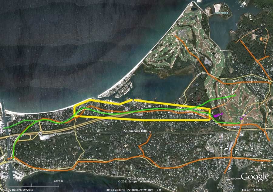
but it is not really relevant to your proposed location, as it only impacts a few hundred yards of your proposed site! See graphic below.
4. You seem to be trying to have it both ways with that 1907 land plan. You've made all sorts of claims about it, including that it is not to scale, but then you try to use it as the exact location of exactly what was planned. In reality, while not perfect, the land plan gives a pretty good idea of both what roads were there before, and what came after. The eastern tail may be the exception to this, as it appears to either be a bit just a bit higher than the roads that existed both before and after.
5. Next time you wonder why we get frustrated with your posts, go back and look at your latest "rough approximation" of the site you originally suggested, and compare it to the the one you actually suggested. They aren't even close. And in some places they leave less than 100 yards width for the entire out and back course! (This doesn't even consider the 60 estates.) This is a perfect example of you fudging the facts in order to try and make your case. As often happens, in the process you end up arguing against yourself, as you can see in the next point.
6. Ironically, your latest proposed site (the new "rough estimation') cuts directly against your all of your arguments for creating the third site in the first place.
a. Your northern border is well north of your original border. So it is even further away from the RR tracks, and not much closer to the RR tracks than the southern point of NGLA!
b. At least your original third site tried to 'stretch along Peconic Bay' for a few hundred yards west of the canal. This fourth one barely touches it.
c. Your new mystery site abruptly elbows north as it stretches east, and its eastern edge is well north of where you have indicated SHGC was located!
In fact even NGLA extends a few hundred yards south of the eastern edge of your new site! Yet you spent weeks arguing that at no point was SHGC adjacent to the east of the land CBM was considering. Now the eastern section of your own site is even further north???
8. Here is a overlay showing (among other things) the routes in question on the 1907 plan as well as the later 1916 Atlas. The 1907 plan is in green, and the 1916 Atlas is in orange. The 1907 Atlas looks like it approximates the 1916 highway. We are talking about the same roads here. And they run right up the gut of your first proposed site, which is yellow.

_____________________________________________