News:

Welcome to the Golf Club Atlas Discussion Group!

Each user is approved by the Golf Club Atlas editorial staff. For any new inquiries, please contact us.


DMoriarty

  • Total Karma: 0
Re: The Creation of NGLA in Chronological, Contemporaneous News Articles
« Reply #900 on: March 14, 2011, 01:13:54 AM »
Andy,

You see how things work around here?  You ask a well-meaning question without any apparent rhetorical agenda, yet even that is enough to send Mike into his latest fit of unsupported logical leaps and misinformation.

1.  Contrary to Mike's ridiculous assertion, I NEVER claimed CBM had finished routing the course by October 1905.   Mike knows this, yet facts won't get in the way when he is trying to make his point.

2.  Mike's latest fantasy relies on the assumption the developer had not determined even the location of the the Shinnecock Inn by mid December 1906.    I don't recall any support for such a claim and Mike clearly hasn't presented any.

So what is this anyway, except the origins of Mike's latest wild goose chase? As usual his conclusion comes first -- CBM couldn't possibly have routed his course by mid-December 1906.   And to support it he is again just blatantly making up things. He apparently hasn't even given much thought to how this supporting theory is supposed to work.  
Golf history can be quite interesting if you just let your favorite legends go and allow the truth to take you where it will.
--Tom MacWood (1958-2012)

DMoriarty

  • Total Karma: 0
Re: The Creation of NGLA in Chronological, Contemporaneous News Articles
« Reply #901 on: March 14, 2011, 01:31:12 AM »
The November 22, 1906, Sag Harbor Express reported that SHPBRC are "at present building a new inn near the Golf Club House."

So, reportedly, the location of the inn had already been determined before the December articles which mention that the 1st hole would be near the inn.  If Mike has a point here, it is lost on me.
Golf history can be quite interesting if you just let your favorite legends go and allow the truth to take you where it will.
--Tom MacWood (1958-2012)

Bryan Izatt

  • Total Karma: 0
Re: The Creation of NGLA in Chronological, Contemporaneous News Articles
« Reply #902 on: March 14, 2011, 01:35:55 AM »
Mike,

In the last sentence of the penultimate paragraph on pg 187, CBM says that the location of the property "was more or less remote, three miles from Southampton, where thoroughfares an railroads would never bother us".  Why would he write that if Peconic Bay Realty proposed to build a "highway" across his property?  I know that the writing came well after the fact, and that the proposed road never got built.  Is it possible that Olmstead got carried away or erred in drawing their map of the property and that there was never any intent to build a road where they put it?  


Bryan Izatt

  • Total Karma: 0
Re: The Creation of NGLA in Chronological, Contemporaneous News Articles
« Reply #903 on: March 14, 2011, 01:47:10 AM »

The November 22, 1906, Sag Harbor Express reported that SHPBRC are "at present building a new inn near the Golf Club House."

So, reportedly, the location of the inn had already been determined before the December articles which mention that the 1st hole would be near the inn.  If Mike has a point here, it is lost on me.

David,

Does the article happen to mention whether there was an existing Shinnecock Inn there already that they were replacing.  Interesting that it's reporting that they are already building the Inn in November when the land deal didn't close until December.  I guess they were confident of the deal.

Back a page or so; thanks for the 1873 map.  I had been searching for it, but could not find it on-line.  Did you find it on-line?  Could you tell me where?  An IM would be fine if you don't want to publish it.

Interesting about the northern track.  Too bad the map is not to scale.  It can't be overlaid on any of the other maps, so not sure where the track is actually located.  In any event, it seems to have disappeared by the 1903 USGS survey map and it's not on the 1905 Automobile Map.  Because of the scaling issues, it's hard to tell if it matches the 1916 North Highway. 


Mike Cirba

Re: The Creation of NGLA in Chronological, Contemporaneous News Articles
« Reply #904 on: March 14, 2011, 07:16:05 AM »
Bryan,

There was a Shinnecock Inn prior, which also burned down.   It was on a different site, closer to Southampton.

This Shinnecock Inn was NOT built for NGLA.   It was going to be built anyway by Alvord's group for rich folks escaping from the city.

CBM just realized that if his members could stay there after travelling 3 or so hours from the city, he could avoid building a clubhouse, at least for the first couple of years while they built their course.

The first report I've found that indicates they intended to build the Inn was in mid-November, 1906.   I believe it opened in the March/April 1907 timeframe.


btw...I don't think the site going west towards the Inlet with Shinnecock Hills GC to the east was a "third location".   

I believe it was the "Canal Site" referred to by CBM in his book, and if I get the chance today I hope to explain why I thnk that later.

« Last Edit: March 14, 2011, 07:20:44 AM by MCirba »

Mike Cirba

Re: The Creation of NGLA in Chronological, Contemporaneous News Articles
« Reply #905 on: March 14, 2011, 07:28:41 AM »

Mike,

In the last sentence of the penultimate paragraph on pg 187, CBM says that the location of the property "was more or less remote, three miles from Southampton, where thoroughfares an railroads would never bother us".  Why would he write that if Peconic Bay Realty proposed to build a "highway" across his property?  I know that the writing came well after the fact, and that the proposed road never got built.  Is it possible that Olmstead got carried away or erred in drawing their map of the property and that there was never any intent to build a road where they put it?  


Bryan,

That's a good point.

I can tell you what I think.    I think at the time the map was drawn NGLA was still only "undetermined" in terms of its borders, with the only certainty being that CBM would choose 205 of the 450 acres available on that site, as all the reports in December 1906 stated after he "secured" the property.    

I think the Planners thought it would be advantageous to have a motor route go right to the golf, and imagined it running right between the two courses.   You'll note that the proposed road ran north of all of the land of Shinnecock Hills GC at that time, and I'm thinking that Olmstead and the other planners imagined all of NGLA would be somewhere North of their road.

I don't think they knew CBM wanted to go as far south (as close to the Shinnecock Inn, actually) as he did in selecting his land, thus they drew what they hoped for, not what CBM eventually chose.

By the time this map was published, we don't know yet (the final deal closed sometime in "Spring 1907") if the exact boundaries of the purchase were determined, so the map wasn't yet revised for advertising purposes, and probably never was.

The highway just didn't get built as planned because CBM decided to include that southermmost section in the planning for his golf course, a process which took place and was finalized sometime after he secured 205 undetermined acres in December 1906 and his final purchase in Spring of 1907

As we've noted, a number of things on that map differed from "proposed" to what eventually got built.
« Last Edit: March 14, 2011, 07:40:30 AM by MCirba »

Jeff_Brauer

  • Total Karma: 4
Re: The Creation of NGLA in Chronological, Contemporaneous News Articles
« Reply #906 on: March 14, 2011, 08:14:14 AM »
Mike,

While all that could well be, and no doubt that a lot of things were being planned simultaneously, my sense is that once the planned roads were donated to the state, they had a lot to say about it.  It would appear that they preferred both roads end up at Southampton, which had to be the center of the action back then.

David,

I hope you meant to type that you never contended the routing was done by Oct 1906, not Oct 1905! You are usually more precise than that. That said, I had always understood your contention that most of the big picture items had been completed by Oct 1906 and it was only minor tweaks occurring after December.  I take it that using the Inn would be a big picture item.

That said, if announced in Nov 1906, Alvord and CBM both surely knew about it before then and the idea to start and finish there certainly had to have occurred to them.  On the other hand, we always presume that the tweaking had to do with Redans and Alps. It could very well have had something to do with the final route of the road, etc.

I still agree with you that the planning was ongoing from probably June 1906 when he started to ride the land until the day they dropped the grass a year later.  It is usually that way.  We will probably never know many of the details, but those are exactly the details which fascinate me.
Jeff Brauer, ASGCA Director of Outreach

JESII

  • Total Karma: 0
Re: The Creation of NGLA in Chronological, Contemporaneous News Articles
« Reply #907 on: March 14, 2011, 12:02:34 PM »
Do we know that the December agreement was contractual beyond the newspaper articles using the word "secured" or "purchased"?

Mike Cirba

Re: The Creation of NGLA in Chronological, Contemporaneous News Articles
« Reply #908 on: March 14, 2011, 12:27:50 PM »
Jim,

Yes.

JESII

  • Total Karma: 0
Re: The Creation of NGLA in Chronological, Contemporaneous News Articles
« Reply #909 on: March 14, 2011, 01:23:39 PM »
How?

Assuming it's not something you're going to post on here (or else you already would have I'd think), does it use the words "undetermined" or "to be located later", or anything to imply they didn't know where it was going to be?

The inclusion, or exclusion of those concepts should shed all the light you need on the state of the planning.

Mike Cirba

Re: The Creation of NGLA in Chronological, Contemporaneous News Articles
« Reply #910 on: March 14, 2011, 02:11:46 PM »
Jim,

I'm not sure which of these you missed prior?


Mike Cirba

Re: The Creation of NGLA in Chronological, Contemporaneous News Articles
« Reply #911 on: March 14, 2011, 03:21:06 PM »
Jeff,

I think what you suggest about CBM and Whigham finding the site sometime after his return to the states in mid-June 1906 and this taking several months is a very possible scenario.

However, if I had to bet my house on what happened, here's what I think transpired.

First, I don't believe that CBM made an offer in late 1905 for land near the Canal.   Given a total of 2700 acres to explore and consider, I doubt very much that CBM would have jumped on the first 120 acres he found near the Canal.   In fact, I think the only thing that CBM did in the weeks after that purchase is consider how the development plans that Alvord's group was trying to quickly put together that included infrastructure and travel considerations now suddenly made a place as far out as Shinnecock Hills viable for his proposed club.

CBM had played out there before at SH, and was probably impressed with the general land forms and sand-based soil for golf, as well as the nearness to the sea and wind, so I think the last domino he wanted to see tumble was more logistical and economical than golf-related.

I think he had in his mind that Shinnecock was "the place", and then went abroad to take his final graduate studies in course architecture in the first half of 1906.

On the 20th of June, 1906, the following article appeared.   At this time CBM is still saying he is looking for sites in a variety of places.   He also tells us that only 3 or 4 of the holes will be exact reproductions;


On October 15th, 1906, a New York paper printed the following, with the supposed location being somewhere between Shinnecock Hills to the East, near the Cold Spring Inlet to the west, the LIRR to the south, and Peconic Bay to the north.

David and most here have contended that this property is that of Sebonac Neck, which CBM eventually purchased.   I don't agree for a number of reasons.
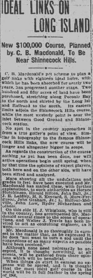


On November 1st, just a few days after the Lesley Cup matches, two reports surfaced that cast further confusion, as it seems clear that the original reports about CBM having already secured "250 acres" of land anywhere was clearly in error;

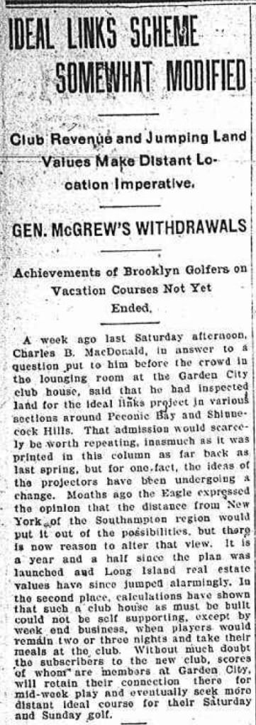


This is complete speculation on my part, so I would appreciate any feedback that's civil and constructive.   But, I believe that CBM was correct when he told us that he and Whigham decided over 2 or 3 days on horseback that the land was what they wanted and I believe they went to get agreement from Alvord's group hastily once they made that determination.

I don't think the June-October story washes with that memory of CBM's, especially since the actual contract to secure the land wasn't signed until mid-December and the contracts to purchase the specific acres wasn't signed until sometime the following Spring!

Instead, I think the land I laid out previously was the land CBM first considered, and what he later referred to as the land near the "Canal".

I guess I can't get over the issue of three directional landmarks being so either distant from today's NGLA or strained definitions, such as Shinnecock in 1906 being "East" of NGLA.   With that in mind, let's look again at the land I originally suggested CBM very well may have been considering.

First, it's important to note that earlier David measured NGLA from end to end and tells us that it runs 2 miles in each direction.

Assuming that CBM would want a similar course in another location to have lots of waterfront and possibly an out and back routing to maximize efficiency, the following shows what two miles (in red) starting at the east side of Shinnecock Hills (and the Shinnecock Inn) and going westward towards Good Ground and the Inlet at Cold Spring would look like in terms of distance covered.

Assuming also that CBM either wanted 250 acres, or that the newspaper transposed the 205 acres he'd been looking for, it looks to me like one could probably build a whale of a golf course there.   It's also pretty obvious that the course would/could have a long stretch along Peconic Bay to the north.


To give you an idea of why CBM may have called this land near the "canal" this aerial shows the proximity of the canal at Good Ground to the west;


Now, CBM tells us that he made an offer for only 120 acres, not 205, and certainly not 250.

Here's what I think happened...

I think CBM had initial discussions and tried to get the whole 205 he'd been looking for right in the prime real estate area as indicated.  I do think the newspaper in NY reporting it initially likely transposed or misreported that number, but it could have been 250, I guess.  In any case, we do know that CBM was looking for that 205 acres because 110 or so would be used for the golf course, another 5 for clubhouse and surrounds, and then the other 90 for 1.5 acre building lots for the Founders.

I think someone took CBM's initial offer or informal discussion with the developer as a done deal, or misreported it as fact, or CBM may have even planted the story,  but we know it didn't fly for whatever reason.

What I think happened is that the Developer, rightly so, told CBM that such a plan took too many of his prime real estate lots that Alvord had hoped to make a killing on, primarily through the sale of large estate subdivisions.

CBM may at that point have decided that his Founders could always buy their own properties out there from Alvord if they were so inclined, and then came back later to Alvord with an offer for only the 120 acres or so he believed he needed for golf, which is the offer he mentioned in his book.

I think CBM tried to put some pressure on Alvord with the November articles where he said he was still looking at Montauk, and also said he may have to look elsewhere if he couldn't get a better price....very good negotiating moves.

I think Alvord came back rejecting that offer, but also referring to CBM that he might want to look at some other property further to the northeast, which also had water views, sandy soil, etc., but that wasn't as optimum for real estate development as the land where CBM made his first offer.

I think sometime after November 1st, CBM and Whigham got on horseback for 2 or 3 days and got excited at the possibilities and determined if they could get the land for the same price as their first offer ($200 an acre) they would make an offer on the 205 they felt they needed.

Not wanting to lose his chance to build in the Shinnecock Hills, I think CBM acted quickly to secure an undetermined 205 acres there on his consolation site, and signed a contract to that effect within weeks.

« Last Edit: March 14, 2011, 03:23:15 PM by MCirba »

DMoriarty

  • Total Karma: 0
Re: The Creation of NGLA in Chronological, Contemporaneous News Articles
« Reply #912 on: March 14, 2011, 03:25:07 PM »
I see Mike Cirba is ready jump ship from his discredited mystery-third-site-theory back to his discredited the-land-near-the-Canal theory.  How many times has be been back and forth between these?   I've lost count.

Strange how he can't make up his mind as to what these articles referred, yet he remains absolutely certain they couldn't possibly have refered to the Sebonack Neck land.  Obviously his desired conclusion is driving all this, as usual.

Hopefully this time around his "analysis" while address the following question:

If the land described in the October articles was the 120 acres near the Canal (discussed in Scotland's Gift,) then why did CBM write about not wanting to be near the SHGC and about how he had made an offer for 120 acres near the Canal?  The Canal was about three miles away from SHGC, which was as far away as one could get from SHGC and still be on the SHGC land!

Likewise, I hope this time he addresses each point raised in my post a few pages back explaining why I don't believe that the October articles were describing the 120 acres near the Canal.  
____________________________________

Jim,  

I don't think Mike answered your question, did he?    Weren't you asking about what information we have about this option agreement other than what appears in these December articles and in Scotland's Gift?  

I am curious as to the basis for his "Yes" answer, and am equally curious as to his bases for the rest of the bald claims Mike has been making recently about a variety of facts.  
________________________________________________________

Bryan,

The 1873 map is online from the NYPL's Digital Library.  The 1916 Atlas pages you posted are there as well (w/o watermark.) http://digitalgallery.nypl.org   Let me know if you need a more detailed location.  

[By the way, if I recall correctly, a while a go you (or someone else) was looking for the location of Canoe Place.  It looks to have been adjacent on to the east side of the canal along Southampton Bay.]  

I am not so sure I am willing to put my faith into the accuracy and completeness of the 1905 road map.  Likewise for the 1903 USGS survey.  You seem to be assuming that these maps showed every road, public and private, and I am not sure that was the case.  Plus the 1903 survey does to appear to have marked all the roads and buildings.  The SHGC clubhouse and outbuildings are not on marked on the map. Likewise, some of the various roads which reportedly ran through or around the course, such as Cold Spring Road and Raynor Road, also seem to be missing.

You guys seem to be assuming that the road cutting across NGLA in the 1907 overlay was NOT an already existing road.  I am not sure that this is a safe assumption.  Judging from the location of the Inn and the large "to SOUTHAMPTION" written above St. Andrews Road down by the RR tracks, it looks as if the developer was planning on that route being the main road to Southampton, and I don't think it makes sense that the developer would build another road to Shinnecock in addition.

In other words, some semblance of the north road may well have been in existence at the time CBM was planning his course, and that alone would explain why it would appear on the 1907 developers schematic.  
___________________________________


Jeff Brauer,

Yes, I meant October 1906.  While I don't think it really matters to my point or yours but to nonetheless to set the record straight, I don't think I have ever "conten[ded] that most of the big picture items had been completed by Oct 1906 and it was only minor tweaks occurring after December."  It could very will be that this was the case, but I don't think I have enough information to speculate one way or another.

_______________________

I posted before reading mike's post above.  I'll take a look at his post and address it later, if necessary.  
« Last Edit: March 14, 2011, 03:44:22 PM by DMoriarty »
Golf history can be quite interesting if you just let your favorite legends go and allow the truth to take you where it will.
--Tom MacWood (1958-2012)

DMoriarty

  • Total Karma: 0
Re: The Creation of NGLA in Chronological, Contemporaneous News Articles
« Reply #913 on: March 14, 2011, 03:38:48 PM »
I read Mike's post.    It isn't even necessary to fully respond because it is just a rehash of his same old misreading of the general description provided in those October articles, along with a bunch of wishful thinking about what he would have liked to have happened.  This latest theory doesn't even begin to address the many reasons why I don't think the October articles were describing the 120 acres near the Canal.  

It wouldn't be a Cirbaian theory if he weren't misrepresenting both my position and the source material. I'll not get into all of it, but I want to note that Mike misrepresented what I wrote about CBM's description of the parcel being 2 miles long.    
« Last Edit: March 14, 2011, 03:40:54 PM by DMoriarty »
Golf history can be quite interesting if you just let your favorite legends go and allow the truth to take you where it will.
--Tom MacWood (1958-2012)

Andy Hughes

  • Total Karma: 0
Re: The Creation of NGLA in Chronological, Contemporaneous News Articles
« Reply #914 on: March 14, 2011, 04:24:55 PM »
Why does everyone assume CBM wanted to have as much water frontage as possible? He loved St Andrews and Prestwick and thought them worthy of study/imitation--I would not really consider either to be waterfront in the sense everyone means with the Sebonac Neck property.  There has been a lot posted here and I may well have missed it but did he ever really say 'I would love for me dream course to have a number of holes alongside the deep blue sea'?

And yes, I do admit he raves about the water feature hole up in the corner, but it isn't being alongside the water that he finds appealing but the specific strategy it will enable him to employ (Cape) that he wants.
"Perhaps I'm incorrect..."--P. Mucci 6/7/2007

Mike Cirba

Re: The Creation of NGLA in Chronological, Contemporaneous News Articles
« Reply #915 on: March 14, 2011, 04:34:44 PM »
Here's the funny part...

If I were actually biased, or intellectually dishonest I'd be arguing like heck that those October articles were the land of NGLA!  ;D

That would pretty much end once and for all this nonsense about routing the course in a day or two.

That timeline would look something like this;

August - CBM Finds the site on horseback with Whigham and studies the land.   Decides he likes it, gets it surveyed, mapped, cleared, and studies it some more.   Spends a lot of money on postage.

September - October - CBM studies that land some more, reads the feedback on his maps,  and makes an offer of some type that gets reported.

November - CBM continues studying the land.

December - CBM signs contract to secure 205 "undetermined" acres of the 450 available.   States he'll spend the next five months with his committee studying the land.

May 1907 - After studying the land for most of the past year, CBM finally decides the borders of this property and signs a purchase contract.

;)
« Last Edit: March 14, 2011, 04:37:35 PM by MCirba »

Patrick_Mucci

Re: The Creation of NGLA in Chronological, Contemporaneous News Articles
« Reply #916 on: March 14, 2011, 05:03:38 PM »

Why does everyone assume CBM wanted to have as much water frontage as possible?

Andy,

I agree with you.

I think that assumption is more of a modern day quest for eye candy.

Macdonald's PRIMARY goal was to site his ideal/classic holes, not create views.

He tells us that he was looking for topography that would best receive his ideal/classic holes, not provide optimal views.
[/b]

He loved St Andrews and Prestwick and thought them worthy of study/imitation--I would not really consider either to be waterfront in the sense everyone means with the Sebonac Neck property.  There has been a lot posted here and I may well have missed it but did he ever really say 'I would love for me dream course to have a number of holes alongside the deep blue sea'?

Not that I can remember.
Again, his primary goal was to site his ideal/classic holes, not produce views.

I believe that those supporting the notion that he wanted more Peconic Bay holes are misguided for two reasons,
1.     His stated goals
2.     The inability to get back to the Shinnecock Inn by way of his Alps and Redan.
[/b]

And yes, I do admit he raves about the water feature hole up in the corner, but it isn't being alongside the water that he finds appealing but the specific strategy it will enable him to employ (Cape) that he wants.

He goes beyond that, he touts the fact that his "Eden" is improved because topped shots wouldn't be able to run up on the green.

Patrick_Mucci

Re: The Creation of NGLA in Chronological, Contemporaneous News Articles
« Reply #917 on: March 14, 2011, 05:37:27 PM »
The significance of the 1873 map is that it proves the long term existance of THE major East-West road/highway on the North Shore of the South Fork, dating from 1873 and earlier, through 1916 and beyond.

Mike claimed, despite having seen the 1903 map, the New York State Senate minutes of 1906 and the Olmstead 1907 map, that the North Highway didn't exist in 1916.

Then, when forced to admit it existance, he claimed it was nothing more than a "cart path", in an attempt to dismiss it's significance as THE MAJOR East-West road/highway on the North Shore of the South Fork.

The North Highway, was one of only two major East-West roads traversing the South Fork.

Denying its existance, in the face of overwhelming source documentation, reveals Mike's propensity to ignore the facts in pursuit of his goal.
Secondly, and perhaps more importantly, the existance of the North Highway, running right smack down the middle of the Olmstead map, undermines Mike's theory on the potential location of NGLA.

Nobody in their right mind would craft an elongated, narrow golf course, restricted on the North property line, with THE MAJOR THOROUGHFARE running right down the middle of the golf course.

It doesn't matter if it was a dirt road or a paved road, it was the main, if not the only commercial thoroughfare running East-West on the North Shore of the South Fork.

When you consider that land prices were increasing, that developers were developing the land, that a new hotel was going to be sited on the North Highway, one had to know that the North Highway would only get busier.  That it would continue to be the main artery for commercial, residential, social and vacation travel on the North Shore of the South Fork.

Mike's advocacy for CBM choosing that long, narrow strip of land, bounded by the railroad to the south and water to the north, with the North Highway running right smack down the middle defies logic.

Lastly, Mike continually relies on newspaper articles as being factually correct, when he and others have already admitted that they're seriously flawed.

Why would you base any conclusion on seriously flawed newspaper articles ?


Patrick_Mucci

Re: The Creation of NGLA in Chronological, Contemporaneous News Articles
« Reply #918 on: March 14, 2011, 06:06:48 PM »

Patrick,

Our understandings of the North Highway are not similar at all, but its of no real import to me.

Perhaps the map from 1873 will prove what I've been telling you, namely, that the North Highway was the ONLY Major East-West thoroughfare on the North Shore of the South Fork, and that nobody in their right mind would select a long narrow strip of land with THE major artery running right smack down the middle of it, for their golf course.
[/b]

I will also continue to disagree that anything to do with designing a golf course or routing it is an easy excersise.

I think there are two reasons for that.
1.  Your ego
2.  Your context.

With respect to context, you're forgetting that he didn't have to design the golf course after he found/determined the land, he'd already accomplished that task vis a vis the previous determination of his ideal/classic holes.

All he had to do was sequence them on the land he picked.

We know he almost picked 120 acres to the West.
We know that he considered Montauk.

Had he been successful in purchasing the 120 acres to the West, he would have placed his ideal/classic holes on that land.
Again, he didn't have to design any holes.  He'd already done that.  Think of project in the context of "pre-fab".
He had the holes done, they'd been "pre-fab'd" in an earlier process.

All he had to do was place his ideal/classic holes where he felt the land best accomodated them, be that on the 120 acres near the canal, the land at Montauk, or the eventual site at NGLA.

Once he rode the land, determined that he wanted the long, narrow strip starting and finishing at the Shinnecock Inn, adjoining Shinnecock Hills GC, down to Bulls Head Bay for his Eden and Cape, then up to his 9th hole along Peconic Bay, then back to the Shinnecock Inn by way of his Alps and Redan, the course routed itself.  This was not a complicated task where an architect does NOT have a preconceived selection of holes.
CBM had his holes, all he needed was the land to place them on.
He almost placed them on 120 acres to the West.  Instead, he placed them on an even better slice of land that became NGLA.

I have every confidence, that if you had 18 pre-determined holes for a golf course, had 450 acres to choose from, that you could do a  basic routing within half a day, especially if you knew your starting and finishing POINTS, and the location of four to six critical holes.

How many times did early architects stake out a basic routing in a day ?

Patrick_Mucci

Re: The Creation of NGLA in Chronological, Contemporaneous News Articles
« Reply #919 on: March 14, 2011, 06:15:00 PM »

The objection David and Patrick originally raised that there couldn't have been a golf course built along the southern stretches of Cold Spring Bay going westward from Shinnecock Hills because a highway ran through it has been thoroughly debunked with clear historical documentation.

Mike, I must have missed the "debunking" part.  What "historical documentation" are you referencing ?

The map dated 1873 ?
The map dated 1903
The NYSS document dated 1906
The map dated 1907
The map dated 1914
The map dated 1916.

Would you tell me what historical documentation has debunked the existance and importance of the North Highway, the highway that runs smack down the middle of your alleged golf course ?


Jeff_Brauer

  • Total Karma: 4
Re: The Creation of NGLA in Chronological, Contemporaneous News Articles
« Reply #920 on: March 14, 2011, 08:50:22 PM »
Patrick,

Context maybe. Ego no.  With all due respect, and allowing that you are entitled to your opinion, you just don't know what you are talking about, either with the road, and especially with the routing.  Looking back with hindsight, its easy to see how the routing came together.  We have no way of knowing if that is how it actually came together, and the whole process of finding the contours (without a topo map, apparently) fitting the holes together, etc. couldn't have been any easier then than now.

Even if Ross and Bendelow did one day routings, it was because they were paid $50 or whatever, and they were going to be done in a day, because that was all it was worth to them.  This was CBM's baby, and as has been pointed out he changed the routing (by lengthening it) for several years.  I doubt he would rush it.  Its a different animal.

Have a good one.
Jeff Brauer, ASGCA Director of Outreach

Patrick_Mucci

Re: The Creation of NGLA in Chronological, Contemporaneous News Articles
« Reply #921 on: March 14, 2011, 09:20:38 PM »
David Moriarty,

What Mike forgets is that the only site/s where one can see both the Atlantic and the Peconic is near the canal and not where Mike claims with his red line marking in post # 911.

Remember, it was Mike who posted the articles stating that you could see the Atlantic from EVERYWHERE on the property except the low lying areas.

You can NOT see the Atlantic from anywhere on his red line, let alone EVERYWHERE on the property except the low lying areas.

His own prior position contradicts his latest claim

Patrick_Mucci

Re: The Creation of NGLA in Chronological, Contemporaneous News Articles
« Reply #922 on: March 14, 2011, 09:47:03 PM »
Patrick,

Context maybe. Ego no.  With all due respect, and allowing that you are entitled to your opinion, you just don't know what you are talking about, either with the road, and especially with the routing.

I'm 100 % correct on the road.
Source documentation from 1873, 1903, 1906, 1907, 1914 and 1916 supports my position, while you, Mike and others have nothing to support your position.

As to the routing, I think linear reasoning/geometric logic, along with finite acreage, three clearly defined borders and critically positioned holes support my position 
[/b]

Looking back with hindsight, its easy to see how the routing came together. 
While that's true, we also have CBM's account and Max Behr's reaffirmation, along with the geometry of the property and the out and back configuration coupled with the precise location of six to eight initial key links, which expand to 12 key links.
[/b]

We have no way of knowing if that is how it actually came together, and the whole process of finding the contours (without a topo map, apparently) fitting the holes together, etc. couldn't have been any easier then than now.

Jeff, CBM told us that he found the contours by diligently inspecting the property and that he quickly found four (4) critical holes, (Eden, Cape, Alps & Redan)
CBM told us that he quickly found the lines of demarcation to the South, East and North, all that remained was the Western boundary.

You and I both know, that if your starting and finishing points are at the same location, then, when you stretch your outgoing nine to Peconic Bay, you have to return to the Shinnecock Inn, and, once you have to pass through the Alps and Redan holes on that return journey, the basic routing has been determined.  How can you maintain otherwise ?

In addition, CBM tells you he found the Sahara and the Road holes early, thus locking in the routing even more.

It's my belief that CBM NEVER intended his clubhouse to be located right beneath Shinnecock Hill's clubhouse, that he always intended his final clubhouse to be at it's current location.  Thus, with his ultimate starting and finishing holes established, in addtion to his temporary holes, along with his six to eight ideal/classic holes (sahara, alps, redan road, bottle, eden, cape & leven) you have 12 of the 18 holes and you know where his missing original six holes (# 2, 3, 6, 7, 14 & 15) have to go.

You're just being stubborn, which I understand, but, again, if you view the routing process as taking an 18 link chain, and laying it upon the land, in the configuration he describes on page 187 and 188, the routing doesn't stand out, it leaps out at you.
[/b]

Even if Ross and Bendelow did one day routings, it was because they were paid $50 or whatever, and they were going to be done in a day, because that was all it was worth to them. 

This was CBM's baby, and as has been pointed out he changed the routing (by lengthening it) for several years. 

Lengthening holes doesn't change the basic routing.
[/b]

I doubt he would rush it.  Its a different animal.

It's a different animal because he had already designed the individual holes.
He only needed to sequence them.

Once he went from the Shinnecock Inn, along the route he described, up to Peconic Bay, the routing was pre-determined.
Once he inserted just four (4) of the critical holes in that long out and back configuration, the die was cast.  The basic routing complete.
How could it not be ?

205 Acres, 18 links, out and back, along a predetermined outbound path, including two critical holes (# 4 & # 5), up to Peconic Bay, then back to the Shinnecock Inn, passing through holes # 12 & # 13, and you don't think the routing was done ?

Even Max Behr claimed the course routed itself.
Why would he say that if it wasn't true ?
Is Max Behr's word not good enough for you ?(;;)

Bryan Izatt

  • Total Karma: 0
Re: The Creation of NGLA in Chronological, Contemporaneous News Articles
« Reply #923 on: March 15, 2011, 12:59:15 AM »
Patrick,

Without in any way supporting Mike's conception of where the October article said the property was, I think you are absolutely wrong on the road.  You may have skipped some of the postings on the weekend.  The 1873 map is not to scale and doesn't overlay on any other maps or on the modern Google aerial.  Your beloved North highway along with the South Highway, less than one half mile apart, serving perhaps a 1000 people between Good Ground and its surrounding 4 or 5  family hamlets and Southampton is not on  the 1903 map or the 1905 map. The 1903 and 1905 and even the Olmstead map overlay both themselves and the modern physical features.  If you look at the 1873 map, the road appears to go well north of SH up around the small hamlet of Tuckahoe and then down to Southampton.  Its track doesn't map to the 1916 North Highway.  And, again, it is not on the 1903 and 1905 maps.  Maybe they just left that track off because it was insignificant in those years.  And, once again, I don't think it is a necessary prerequisite to knock down Mike's hypothesis.


David,

Thanks for the location of the map.  I'll look it up when I'm out at Bandon and have some spare time.  I was looking to figure out where Canoe Place was because the big article placed the the western boundary of the 2700 (2600) acres at Canoe Place Creek.  As far as I can tell Canoe Place was just west of the present canal.  It seems odd that the ad used Canoe Place Creek as a boundary when the canal had been there for 25 years.  Could there have been a Canoe Place Creek and a Shinnecock Canal in 1917?  I hoped the 1873 map would shed some light.


Bryan Izatt

  • Total Karma: 0
Re: The Creation of NGLA in Chronological, Contemporaneous News Articles
« Reply #924 on: March 15, 2011, 01:15:54 AM »

From a George Bahto thread three years ago:

Quote
Two or three years before The Evangelist of Golf was published I saw the article Henry Whigham wrote about his father-in-law Charles Macdonald just after Charlie had passed away. It is framed, under glass and hangs just to the left of the front desk at The National’s clubhouse.

The 3,200+ word article was written as a eulogy and cited the many deeds of Macdonald.


..................................


Here are a few paragraphs from the Whigham article and you can do with it whatever you please.

Article in part:

*   *

“I went out with Macdonald to ride over the land which is now the National, and on coming back to the Shinnecock Club for lunch we found four elderly members awaiting us with dire prophecies of what would happen if we selected a site so near their own club, one of the first three golf clubs in America and the most fashionable. Yet on that first Saturday of September in 1907 there were only four old members in their sixties or seventies in the clubhouse, and they confessed that they had to contribute a pretty penny each year to keep things going.

Now, I'm sure that somebody questioned or corrected this last paragraph somewhere in the back pages, but I missed it.  So what does it mean that Macdonald and Whigham rode the course in September 1907?  Did Whigham get it wrong?  Did George mistranscribe it?  Surely it can't be the right year.  But is it the right month?  Was it September 1906?