News:

This discussion group is best enjoyed using Google Chrome, Firefox or Safari.


Bryan Izatt

  • Karma: +0/-0
Re: The Creation of NGLA in Chronological, Contemporaneous News Articles
« Reply #825 on: March 11, 2011, 03:01:52 AM »


Mike,

One other question when you resurface.  The October article supposedly locates the 250 acres CBM supposedly bought.  If I recall correctly somebody showed that the current NGLA layout is pretty tight to 205 acres.  Where do you suppose the extra 45 acres to make up the 250 acres might have been situated relative to the current course?  Maybe just west of SH?


Jim Nugent

Re: The Creation of NGLA in Chronological, Contemporaneous News Articles
« Reply #826 on: March 11, 2011, 03:24:06 AM »


Mike,

One other question when you resurface.  The October article supposedly locates the 250 acres CBM supposedly bought.  If I recall correctly somebody showed that the current NGLA layout is pretty tight to 205 acres.  Where do you suppose the extra 45 acres to make up the 250 acres might have been situated relative to the current course?  Maybe just west of SH?


When I saw this, I thought maybe someone reversed the 0 and 5 from 205 to create the mistaken 250. 

Mike Cirba

Re: The Creation of NGLA in Chronological, Contemporaneous News Articles
« Reply #827 on: March 11, 2011, 07:58:50 AM »
Jim,

I assumed it was a transposition, as well.

Bryan,

Why the hard edge to your questions?  

I'll get to the others by weekend but as far as your last one I already stated that I don't believe the land in question was the land CBM later purchased.

Also, that road marked North Highway didn't exist in that location in 1906 or 1907...it was a proposed road on the Olmstead Bros. Land Plan and a proposed major artery that if built would have run right between NGLA and Shinny.  Do you really believe they would have run that thru an existing golf course?
« Last Edit: March 11, 2011, 10:49:48 AM by MCirba »

Andy Hughes

  • Karma: +0/-0
Re: The Creation of NGLA in Chronological, Contemporaneous News Articles
« Reply #828 on: March 11, 2011, 08:25:29 AM »
Quote
Do you really believe they would have run that thru an existing golf course?

Mike, you mentioned that earlier--not sure why you believe that to be so unlikely when so many courses have roads through them. Oakmont had the turnpike slice through it, and even mighty Glenbrook has several holes bisected by roads :)
Or are you saying that with available, vacant land nearby, why would they have gone through an existing course when they didn't have to?
"Perhaps I'm incorrect..."--P. Mucci 6/7/2007

Mike Cirba

Re: The Creation of NGLA in Chronological, Contemporaneous News Articles
« Reply #829 on: March 11, 2011, 08:41:23 AM »
Andy,

These guys were planning their ideal community.  

This was a plan, not a reality.

Not much existed out there yet, except Shinny and now CB had just secured land adjacent.


Alvord was trying to get people out there to the Inn and golf courses.

Why would he risk destroying/diminishing the one that had been there for fifteen years...this was going to be a major artery through Shinnecock out to Southampton, not a side road.

This wasn't something planned by some govt. agency without regard for the golf course...these guys were planning their own roads, etc.
« Last Edit: March 11, 2011, 10:49:06 AM by MCirba »

Jeff_Brauer

  • Karma: +0/-0
Re: The Creation of NGLA in Chronological, Contemporaneous News Articles
« Reply #830 on: March 11, 2011, 11:31:25 AM »


Way OT, but I wonder if any auto mfg these days would take any styling cues from this era? 
Jeff Brauer, ASGCA Director of Outreach

Mike Cirba

Re: The Creation of NGLA in Chronological, Contemporaneous News Articles
« Reply #831 on: March 11, 2011, 11:57:03 AM »
Bryan,

Here's Shinnecock Hills in 1915.

You might want to compare with whatever you used for your drawing from 1916 so if you could share that here it would be helpful.

I've edited your map a little bit to show where the boundaries roughly were a year prior.  I also filled in the rest of NGLA so that the distinct north-south orientation of both course properties is more obvious.

Thanks!


« Last Edit: March 11, 2011, 12:02:17 PM by MCirba »

JESII

  • Karma: +0/-0
Re: The Creation of NGLA in Chronological, Contemporaneous News Articles
« Reply #832 on: March 11, 2011, 12:10:24 PM »
Mike,

The geographical relationship of the courses in your interpretation there is THE reason you think the October articles were talking about CBM having bought a different piece of land?

Mike Cirba

Re: The Creation of NGLA in Chronological, Contemporaneous News Articles
« Reply #833 on: March 11, 2011, 12:10:43 PM »
Here's a good resolution view of the NGLA course from 1915 as it sits on the 205 acres of land (shadowed) that was purchased.


Mike Cirba

Re: The Creation of NGLA in Chronological, Contemporaneous News Articles
« Reply #834 on: March 11, 2011, 12:18:48 PM »
Jim,

Along with the huge geographical discrepancies of the article versus reality (i.e. Inlet to the west was 1.5 MILES from NGLA's western border, railroad was .35 MI from southern border, Shinnecock clearly south, not east), please see my response #806 to Jeff which outlines my other issues.

Thanks.

Bryan Izatt

  • Karma: +0/-0
Re: The Creation of NGLA in Chronological, Contemporaneous News Articles
« Reply #835 on: March 11, 2011, 12:28:30 PM »
Jim,

I assumed it was a transposition, as well.  So, that makes two errors in the article.  I'm just not sure why if this was a transposition error and if the purchase was misreported that you take a such a literal interpretation of the location as absolutely correct?

Bryan,

Why the hard edge to your questions?  There was no hard edge intended.  I can't get the emoticons to work, so how about calming pink for my in-line responses? 

I'll get to the others by weekend but as far as your last one I already stated that I don't believe the land in question was the land CBM later purchased.  So, you believe that the 250 acres is correct, but that it wasn't actually purchased as reported, but that the location is accurate?  Just seems to be a stretch to me.

Also, that road marked North Highway didn't exist in that location in 1906 or 1907...it was a proposed road on the Olmstead Bros. Land Plan and a proposed major artery that if built would have run right between NGLA and Shinny.  Do you really believe they would have run that thru an existing golf course?  I'm confused as to your point here.  There were roads already running through SH.  Look at the layout you posted and the topo map from 1903.  Building courses with "highways" through them was not that unusual in those days (Merion comes to mind).  And, the Olmstead map stops short of SH, so there's no way to know where the proposed roads would go.  Are you suggesting that Peconic Bay also owned the SH land and that they could determine where the roads through that existing course could go.  Do you have any other source of the precise location of the 2700 acres.  The article you posted with the Olmstead map is not persuasive to me.


Bryan Izatt

  • Karma: +0/-0
Re: The Creation of NGLA in Chronological, Contemporaneous News Articles
« Reply #836 on: March 11, 2011, 12:53:22 PM »
Mike,

My source was the Suffolk County Atlas map that I posted a few pages ago.  The shape of the property matches the shape your drawing shows, with the exception that yours shows the 10th tee across the road on the western edge.  Yours is an unscaled drawing and mine is from a scaled atlas.  I overlaid the Atlas map of SH and the current Google aerial of NGLA onto the topo map so I'm confident of the boundaries.  I think mine is a more accurate representation than yours.

If you draw a line due north through the middle of SH, you'll see that NGLA is west of that line, and hence SH is east of NGLA.  I'm not sure why you take such a narrow interpretation of "adjoin".  CBM said the courses adjoined when they don't in the narrow literal sense you're taking.  The adjoining if there is any literal adjoining, is of the southeast corner of NGLA and the northwest corner of the northern segment of SH at the time.  Just the corners, there was no common boundaries that adjoined.


Bryan,

Here's Shinnecock Hills in 1915.

You might want to compare with whatever you used for your drawing from 1916 so if you could share that here it would be helpful.

I've edited your map a little bit to show where the boundaries roughly were a year prior.  I also filled in the rest of NGLA so that the distinct north-south orientation of both course properties is more obvious.

Thanks!


Mike Cirba

Re: The Creation of NGLA in Chronological, Contemporaneous News Articles
« Reply #837 on: March 11, 2011, 01:00:59 PM »
Bryan,

This may help.

In 1906 the "North Highway", dirt road as it was, ran much further south than where it's drawn/proposed on the 1907 Olmstead map.

I've cropped the whole Land Plan and marked the proposed path of the North Highway in red.

As you can see, it runs along the North boundary of Shinnecock Hills GC over on the right.   National is north of there.

Again, this is what was proposed AFTER NGLA had secured their 205 acres, so it would be virtually unthinkable that someone/Alvord would draw his major highway through his area THRU a well-established golf course that had existed for 15 years to that point.


Mike Cirba

Re: The Creation of NGLA in Chronological, Contemporaneous News Articles
« Reply #838 on: March 11, 2011, 01:09:54 PM »
Bryan,

Our posts crossed.

Other than still waiting for David to show us where the North Highway cuts through the 9th and 10th holes of NGLA I think we can agree that we're both picking nits to a degree.

I'll concede that the predominant part of Shinny lay southeast of NGLA if you agree that at least 99% of Shinnecock property was south of at least 99% of NGLA property.  ;)  ;D

I find it odd that anyone would describe the property (as the Oct articles do) as running to SH to the east in the Oct articles, when the property that was purchased stretched along Bulls Head Bay for a mile to the east.  

If anything, they should have mentioned it as running to Shinny at the Southern Border, not the Long Island Rail tracks as they did.
« Last Edit: March 11, 2011, 01:28:59 PM by MCirba »

Bryan Izatt

  • Karma: +0/-0
Re: The Creation of NGLA in Chronological, Contemporaneous News Articles
« Reply #839 on: March 11, 2011, 01:32:45 PM »
Bryan,

This may help.

In 1906 the "North Highway", dirt road as it was, ran much further south than where it's drawn/proposed on the 1907 Olmstead map.  Not sure which 1906 North Highway you're referring to.  Is it not the one that runs below the Shinnecock Inn.  I can't read the legend on the one you've marked in red.  Is that what you're calling the proposed North highway and that you assume it was going to replace the then existing North Highway?

I've cropped the whole Land Plan and marked the proposed path of the North Highway in red.

As you can see, it runs along the North boundary of Shinnecock Hills GC over on the right.   National is north of there.  I assume they thought it would run between the two course properties in the gap between where the two corners that almost adjoin.  :)

Again, this is what was proposed AFTER NGLA had secured their 205 acres, so it would be virtually unthinkable that someone/Alvord would draw his major highway through his area THRU a well-established golf course that had existed for 15 years to that point.   Since there is no scale on that map, it's hard to know exactly where it would run relative to SH.  It could easily be interpreted as running along the northern edge of the SH property.  In any event, is there any evidence that Alvord/Peconic Bay bought SH as part of their 2700 acres?  If they didn't then how could they propose to run a road through property they didn't own.  Or, was eminent domain in use even then?  In any event, there is no road there on the 1916 map so that road didn't get built as proposed.


Bryan Izatt

  • Karma: +0/-0
Re: The Creation of NGLA in Chronological, Contemporaneous News Articles
« Reply #840 on: March 11, 2011, 01:46:01 PM »

Mike,

The article is erroneous in a couple of way.  Not hard to conceive that the description of the location was either erroneous or just general in nature too.  I'm guessing that whoever was the source for the reporter was just giving a broad brush location.  I can't imagine that the reporter had been on-site or knew the area from having been there.  So, I'd guess that the source would have stated it in most general terms according to major landmarks in this completely undeveloped area.  It's hard to fathom that the source meant to say that the eastern boundary literally adjoined the west boundary of SH and only that boundary, as you have drawn it in previous posts.

Although your drawing of the 250 acres is possible, it is not plausible in the context of subsequent events and other articles and books on the subject.

So, I'd say, give up the idea of a third site, but I know that that's probably not possible for you to do.  :)


Mike Cirba

Re: The Creation of NGLA in Chronological, Contemporaneous News Articles
« Reply #841 on: March 11, 2011, 01:55:53 PM »
Bryan,

Love and appreciate the warm, fuzzy, pink print, thanks.   Perhaps we can convince Patrick to convert to that.   Thanks.  ;)  ;D

Would appreciate your thoughts on my post #806 re: those articles versus other related facts that we know to be true.

btw...the proposed "North Highway" ran North of the Shinnecock Inn, not South, and along the North boundary of Shinnecock Hills Golf Course.   You can see where the words "HIghway" continue on that route, and a little further along it says "To Southampton".

Perhaps we should wait to see David's overlay where the North Highway intersects the 9th and 10th holes at NGLA?  ;)

« Last Edit: March 11, 2011, 02:01:28 PM by MCirba »

JESII

  • Karma: +0/-0
Re: The Creation of NGLA in Chronological, Contemporaneous News Articles
« Reply #842 on: March 11, 2011, 02:08:00 PM »
Mike,

I don't know what you think #806 says, but there isn't much meat there.

For that post to mean anything we're back to the debate about the December option being formal or informal.

Why is it more likely that he signed an informal option than for him to have gotten his informal agreement for 205 acres anywhere in that 450 in September or October and then spent the following few months exactly locating it?

Let's forget Shinnecock for a second and think about the fact that there is an article or articles that say he "purchased" or "secured" land prior to mid-October and we have an Option agreement in December. In CBM's own words, that describes the chain of events perfectly.

I'm not arguing that he completely routed the course in 3 days either.

DMoriarty

  • Karma: +0/-0
Re: The Creation of NGLA in Chronological, Contemporaneous News Articles
« Reply #843 on: March 11, 2011, 02:34:35 PM »
Mike Cirba's most recent drawing may be worse than his first.  Look at his own "1915" map he recently posted.  The fifteenth hole started from a point north of the clubhouse and was listed at 464 yards, and the 16th tee was north of that.  Look at the location of the clubhouse on his latest drawing relative to the northern border.  What is there, about 75 yards for this 15th hole?    Mike needs to learn that if he has to twist the facts to make his point, then his point is not worth making.  
__________________________________

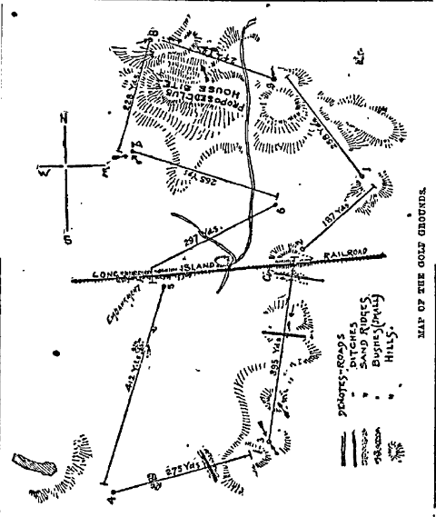
Briefly and roughly:  Shinnecock's original 9 hole course (Davis) was laid out before Shinnecock even owned their land.  When they purchased land (reportedly 80 acres,) the existing course did not fit on the purchased.  Rather, the course extended well south of the RR tracks and south of the southern boundary, and Davis' women's course was reportedly south of the men's course.    Below is the men's course in 1891.  Note that a small portion of the course was north of the clubhouse (first tee, eighth green, and the entire 9th hole.)  


In early 1893, Dunn redesigned much of the men's course. creating a 12 hole course that only used about 10 or 11 acres south of the RR, but extended further north of the clubhouse.    He also moved the women's course to North of the men's course.   Note that the land extends  north of the clubhouse and that a substantial portion of the women's course is north of the interesection of the intersection of Cold Spring and Raynor Roads, both still marked on the 1915 map.  [Mike's latest drawing may not even extend this far north.]  


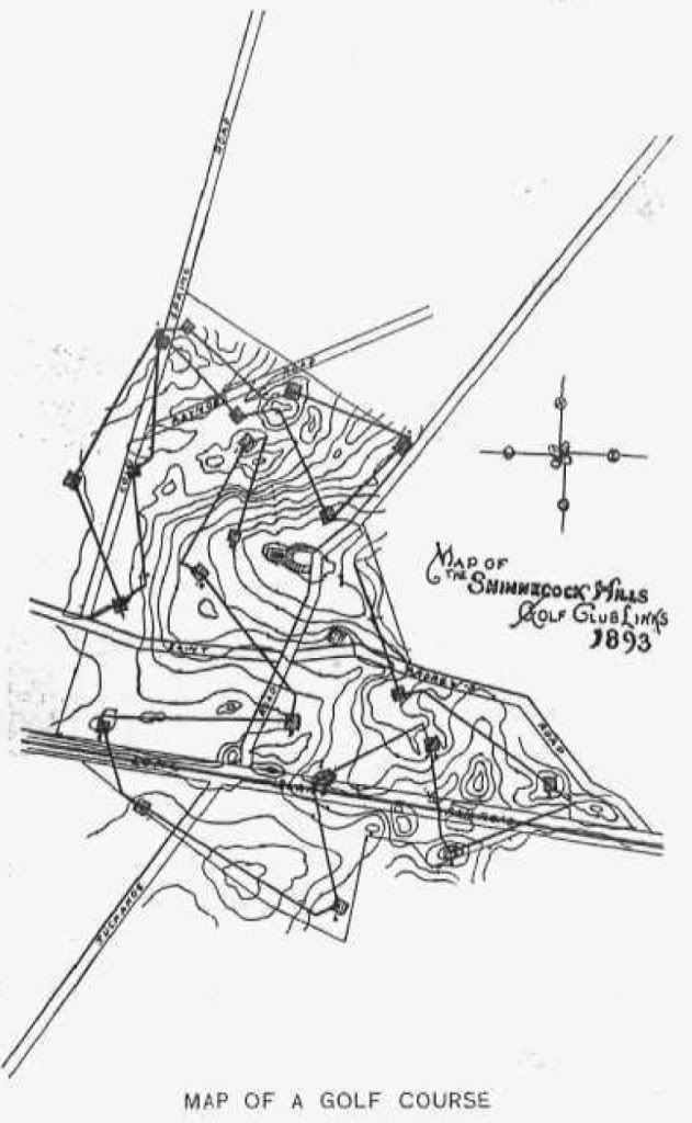
In 1895 Dunn converted the course to 18 holes by adding a western extension of six holes on about 30 acres of land the club had leased (and would later purchase.)  


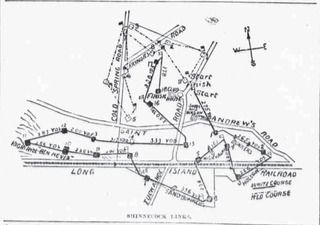
By 1898 the women golfer's (some of whom were extremely accomplished) were reportedly tired of their short "beginners" course and wanted a real course, and they began to usurp the Men's course.  (Reportedly they played the course as a twelve hole course, skipping the loop to the west.)   So in 1898/1899 the club reportedly purchased 20 acres of land to the north of the current course and extended the women's nine into one the longest nine hole courses in the nation.   Below is a early rough rendering of the layout from 1899.  Note that the from a point about even with the clubhouse the 2nd and 3rd run close to straight north and measure a combined  800 yards, and the 4th tee is beyond this.


Between 1900 and 1906 there was reportedly at least one other small land purchase of 5 to 8 acres well north of the clubhouse, toward Bullshead Bay.

So far as I can tell from the maps and various reports, changes which took place between 1900 and the major redo by CBM and Raynor in or around 1917 all took place on the land north of the clubhouse, which was originally laid out as the women's course.   For example, Shinnecock substantially lengthened their course and made other changes in or around 1913 (after NGLA and after Hutchinson had criticized their course) using the land purchased in 1898/1899 for the women's course.  

So while it may be true that the the men's course had undergone changes between 1915 as compared to fall of 1906, SHGC already owned the land.   And by 1906 SHGC's land reportedly extended well north of the the clubhouse; judging from the hole distances on the schematic, close to a half mile north, at least.   And, as mentioned above, Shinnecock had acquired additional land to the north prior to 1906.

In contrast, the 9th green at NGLA is only about 220 yards north of Shinnecock's clubhouse.  (In other words, about 220 yards north, from a point directly east of Shinnecock's clubhouse.)  

So, despite Mike's adamant claims and his deceptive drawings, a portion of the SHGC land was directly east of the SHGC land.   And the land CBM was considering may have even extended further south than this.
« Last Edit: March 11, 2011, 02:44:03 PM by DMoriarty »
Golf history can be quite interesting if you just let your favorite legends go and allow the truth to take you where it will.
--Tom MacWood (1958-2012)

Jeff_Brauer

  • Karma: +0/-0
Re: The Creation of NGLA in Chronological, Contemporaneous News Articles
« Reply #844 on: March 11, 2011, 02:45:36 PM »
Let's see if I can simply sum up the issue before us.  It is whether the October articles are discussing:

1.   The original offer that was rejected as described in Scotland’s Gift, but later than we presumed it happened, given the few dates mentioned for it:
             a.   November 1905, which would be a few weeks after Alvord gained control (as he reports in Scotland’s Gift)
             b.   June 1906, right after CBM got back with his sketches of the great holes he wanted to build (as he also reports in Scotland’s Gift)
2.   Mike is correct and it is some intermediate parcel that was being negotiated, but not mentioned in Scotland’s Gift, based on:
             a.   Reports the original offer was 120 acres not 250 and other mistakes in that October article.
3.   Or the final parcel either:
             a.   Prematurely reported based on rumor or preliminary reports
             b.   Bought, but put off for some glitch, and finally concluded as reported in the December articles.

Frankly, option 3 makes most sense to me.  Glitches happen all the time in deals of this magnitude.  And, it was noted in December that there was general knowledge of the deal, but the Eagle, at least, held off reporting certain items in a gentlemen's agreement, while other papers did leak it.  Leaking from secondary inside sources, like the secretary typing up the agreement, might explain:

* the 205-250 transposition,
* the vague description (maybe they really didn't know where the land was because the principals weren't talking openly about it)
* the option in December, as perhaps whatever glitch or some other aspect of the deal made CBM nervous, and he wanted the safety of knowing he could back out (even more than the ability to move borders around to suit him)

But, its just my guess against others.....

Damn, David made a detailed post before this got posted. I hope I am not confusing the issue with the above, since each of us seems to be arguing way different things, often going past each other.

While I am trying to decide when the offers were made by CBM for the land, others are debating where the heck Shinny was located, presumably to establish the same points I lay out above?

Jeff Brauer, ASGCA Director of Outreach

DMoriarty

  • Karma: +0/-0
Re: The Creation of NGLA in Chronological, Contemporaneous News Articles
« Reply #845 on: March 11, 2011, 03:12:44 PM »
Mike, I am getting a bit tired of you expecting me and others to do all your work for you.  These things take time and I shouldn't have to waste my time addressing claims made with no real support in the first place.   Posts like the above take quite a lot of time and I am tired having to deal with every fantastic and unsupported scenario you create.   Do the damn research before you start stating things as fact.    

I see you expect me to post my overlay.  What a surprise. Your skills with graphics are on par with your skills in historical analysis.

Here is part of my overlay.  Hopefully it puts your latest digression back in the trash bin where it belongs.


« Last Edit: March 11, 2011, 03:27:09 PM by DMoriarty »
Golf history can be quite interesting if you just let your favorite legends go and allow the truth to take you where it will.
--Tom MacWood (1958-2012)

Patrick_Mucci

Re: The Creation of NGLA in Chronological, Contemporaneous News Articles
« Reply #846 on: March 11, 2011, 03:48:03 PM »
Bryan,

The Shinnecock Hills Golf Club course in 1916 was not the same golf course as Shinnecock Hills in 1906.

Here's a clue.

Do you think the proposed "North Highway" running across the south fork to Southampton would have cut right though either the existing Shinnecock Hills GC or the newly purchased NGLA?

Yet it splits right between them in this April 1907 publication.

Macdonald stated, in unequivacal terms that his NGLA site ADJOINED Shinnecock Hills Golf Club.

CBM was a member of Shinnecock Hills, therefore it's my belief that he knew where it was located, despite your claims to the contrary.


« Last Edit: March 11, 2011, 09:38:36 PM by Patrick_Mucci »

Jeff_Brauer

  • Karma: +0/-0
Re: The Creation of NGLA in Chronological, Contemporaneous News Articles
« Reply #847 on: March 11, 2011, 04:05:34 PM »
Mike,

I have to agree you are making a bit much of the north and east descriptions here.

One question. If anyone other than an Olmstead draftsman contemplated the north highway to go in your redmarked location, would there have been any hearings in the legislature in the same time period regarding whether or not there had to be a grade separated crossing with the railroad?  Despite its depiction on that map, those hearings and its subsequent location make clear it wasn't supposed to go where you imagine, don't they?
Jeff Brauer, ASGCA Director of Outreach

Patrick_Mucci

Re: The Creation of NGLA in Chronological, Contemporaneous News Articles
« Reply #848 on: March 11, 2011, 04:16:44 PM »


Bryan & Mike,

Now we have another reliable source map, an independent map showing the existence of the North Highway.
The 1903 U.S.G.S. - State of New York survey.  

You might notice that it's the ONLY EAST-WEST Road on the North Shore of the South Fork, extending East of the Canal.

The canal was created only a few years earlier, and, I suspect the North Highway and the creation of the Canal are directly related

The body of evidence supporting the existance of the North Highway continues to increase as does your absurdly stubborn refusal to acknowledge its existance.

As to your reference that it's a dirt road, almost every road was a dirt road in 1903.
Cars were just being mass produced in 1902.
Just because a highway wasn't paved doesn't negate it's being a major thoroughfare in 1903, which the North Highway was.
In addition, there was such a high volume of traffic on the North Highway that in 1906 the New York State Senate legislated moving and reconfiguring the intersection/crossing of the North Highway with the railroad tracks for safety reasons.
[/b]
[/color][/b]

I guess that CBM was wrong that it was never surveyed.


I'm not so sure about that.

A topo and a survey map are two distinctly different documents.
I have several surveys of the land I own. I"ve never seen a topo of the land I own.
And, I had to pay an engineering firm for the surveys.


[/quote]

Patrick_Mucci

Re: The Creation of NGLA in Chronological, Contemporaneous News Articles
« Reply #849 on: March 11, 2011, 04:27:47 PM »
.
« Last Edit: March 11, 2011, 04:30:21 PM by Patrick_Mucci »

Tags:
Tags:

An Error Has Occurred!

Call to undefined function theme_linktree()
Back