News:

Welcome to the Golf Club Atlas Discussion Group!

Each user is approved by the Golf Club Atlas editorial staff. For any new inquiries, please contact us.


Mike Cirba

Re: The Creation of NGLA in Chronological, Contemporaneous News Articles
« Reply #325 on: February 13, 2011, 12:03:18 PM »
Patrick,

Here's the entire map that was posted in the news article.

I believe it was only meant to represent Shinnecock Hills, and not further east to Southampton.


p.s.   No Topographical map for Merion existed during CBM's one-day visit in June 1910.   He made that point himself in his June 29th, 1910 letter.

By the way, it's you who keeps bringing up Merion here, not me.   You and David desperately want to add it to the pantheon of CBM's courses, so based on that knowledge I'll consider that your "desperate" statement is completely appropo.  ;)
« Last Edit: February 13, 2011, 12:26:19 PM by MCirba »

Patrick_Mucci

Re: The Creation of NGLA in Chronological, Contemporaneous News Articles
« Reply #326 on: February 13, 2011, 12:23:55 PM »

This proposed land was simply empty, surveyed lots at the time CBM was trying to secure it.   This map from seven months later shows only one lot in that whole area having been purchased to date.   As noted, the land CBM eventually purchased looks to be unsurveyed to the far northeast;


Mike, I believe the land you've defined in red is substantially larger than 550 acres.  It's huge.
At it's western end, at the canal, it's miles from the Shinnecock Inn, perhaps David or Byran could measure it..

In post 282 where you originally produced this 1907 rendering, you stated that the course was closer to the North shore and further north of the railroad.  That's not great land for golf, for CBM's ideal golf holes, especially when compared to NGLA.

But, what I don't understand is how you can claim that the North Highway didn't exist.
The Highway that runs right through your alleged golf course.

The North Highway DID EXIST as did the South Highway and the Railroad, in 1906

Mike Cirba

Re: The Creation of NGLA in Chronological, Contemporaneous News Articles
« Reply #327 on: February 13, 2011, 12:31:51 PM »
Patrick,

This map might make it clearer;


In Blue Outline a rough drawing of what 250 acres might look like that had Shinnecock HIlls GC to the East, skirted the LIRR to the South, had its Western boundary near the inlet between the Shinnecock Hills Train station and Good Ground and skirts Peconic Bay to the north..

In Red Outline is a rough drawing of what may have been 120 acres that you and David don't contest that CBM offered to purchase near the Canal.   From the looks of it, your North Highway drawn in green runs right through it too, yet I haven't heard you tell us where you think that land may have been.

Also drawn in purple is the LIRR, with the Shinnecock Station indicated with an X.

What makes you think the North Highway existed in 1906?

btw, Patrick...that topo map makes the area look to have more undulations than either NGLA or Shinnecock HIlls.   Most of the elevation changes you see up in the right hand corner on my map are at Sebonack GC, not NGLA.    You should check it out.
« Last Edit: February 13, 2011, 12:37:57 PM by MCirba »

Patrick_Mucci

Re: The Creation of NGLA in Chronological, Contemporaneous News Articles
« Reply #328 on: February 13, 2011, 12:34:44 PM »
Patrick,

Here's the entire map that was posted in the news article.

I believe it was only meant to represent Shinnecock Hills, and not further east to Southampton.

I just lost an incredibly long post and am trying to put my computer back together again after throwing it against the wall.

The NORTH HIGHWAY existed.
It's what the SHINNECOCK INN and SHINNECOCK CLUBHOUSE driveway clubhouse connected to.
The NORTH HIGHWAY runs right through your phantom golf course.
[/b]


p.s.   No Topographical map for Merion existed during CBM's one-day visit in June 1910.   He made that point himself in his June 29th, 1910 letter.

When you say that NO topo map existed during CBM's visit, are you saying that there was NO topo map in existance, or that CBM didn't have access to one ?
[/b]

By the way, it's you who keeps bringing up Merion here, not me.   You and David desperately want to add it to the pantheon of CBM's courses, so based on that knowledge I'll consider that your "desperate" statement is completely appropo.  ;)

That's also not true.
Earlier, you alluded to a conclusion you drew, that he didn't route NGLA in short order, therefore he couldn't have routed Merion in short order.
That's been your agenda, hidden to some, all along.  You want to dispute CMB's ability to route Merion in short order and this thread is your vehicle to get you from where you were to your predetermined destination.
[/b]

Mike Cirba

Re: The Creation of NGLA in Chronological, Contemporaneous News Articles
« Reply #329 on: February 13, 2011, 12:47:52 PM »
Patrick,

Please show me where CBM ever said he routed NGLA on 2 or 3 days horseback ride.   I've been through everything I can find on the matter and find nothing of the sort.

So, if you can find that somewhere, PLEASE post it....PLEASE, because it must be more hidden than the Holy Grail! ;D

Everything I can find indicates he secured more acreage in December 1906 than he thought he needed for the golf course, more acreage than he actually used for the golf course, and his contemporananously quoted statements have him spending the next several months with his committee determining which holes to repropduce as well as their yardages, finally staking the exact boundaries and completing the purchase outright in the spring of 1907.

Even if we make the silly assumption that these articles talking about a western point near the inlet close to Good Ground are talking about today's course, then there is EVEN LESS evidence that he routed the course in 2-3 days because he'd been riding around it for TWO MONTHS before securing 205 UNDETERMINED Acres in December 1906.   

So, please...enough of this "CBM Said".

If he said he routed the golf course in 2-3 days, please show us where that is.

Thank you.


p.s. As far as Merion, we know CBM told us he didn't have a topo of the property, and without one would be unable to determine whether a first-class course would actually fit on the property.

We also know that later Richard Francis was added to Hugh Wilson's committee for his surveying/engineering skills, and we also know that Pugh & Hubbard drew a scale map of the property in the November timeframe, six months after CBM's visit.
« Last Edit: February 13, 2011, 12:50:51 PM by MCirba »

Patrick_Mucci

Re: The Creation of NGLA in Chronological, Contemporaneous News Articles
« Reply #330 on: February 13, 2011, 12:51:54 PM »
Patrick,

This map might make it clearer;


In Blue Outline a rough drawing of what 250 acres might look like that had Shinnecock HIlls GC to the East, skirted the LIRR to the South, had its Western boundary is near the inlet between the Shinnecock Hills Train station and Good Ground.

In Red Outline is a rough drawing of what may have been 120 acres that you and David don't contest that CBM offered to purchase near the Canal.  

That's not true.
Why do you distort and fabricate things to suit your agenda ?
I NEVER conceded/acknowledged that the property outlined in red was THE 120 acres CBM sought.
[/b]

From the looks of it, your North Highway drawn in green runs right through it too, yet I haven't heard you tell us where you think that land may have been.

Maybe because I NEVER stated that the land in red was the 120 acres CBM looked at.

Stop trying to deflect attention from a huge, embarrassing error on your part, namely, that a major thoroughfare ran right smack down the center of your phantom golf course, thus debunking and destroying your latest theory.
[/b]

Also drawn in purple is the LIRR, with the Shinnecock Station indicated with an X.

What makes you think the North Highway existed in 1906?

I know it did for several reasons.
But, you can't accept that because it destroys the newest version of your theory.
What makes you think it didn't ?

Were there no roads to service the RR station ?
You're so desperate to prove that CBM couldn't have routed NGLA, ergo Merion, in short order that you're willing to distort and fabricate the truth and facts.
[/b]

btw, Patrick...that topo map makes the area look to have more undulations than either NGLA or Shinnecock HIlls.

You don't know what you're talking about.
The area you've defined inside of your blue line has NO topo north of the green line and very little south of it.
The larger map you presented shows the entirety of the East End in terms of Land between the Ocean and the Sound, but, that's not the land you defined in your blue perimeter.  That land is comparitively FLAT and looks NOTHING LIKE the land at NGLA and Shinnecock.
If you knew what you were talking about, you'd know that from first hand observations.

WHY DO YOU MAKE THINGS UP AND OFFER THEM AS FACTUAL ?  ?  ?   ?   ?    ?        ?
[/B]    

Most of the elevation changes you see up in the right hand corner on my map are at Sebonack GC, not NGLA.    You should check it out.
I'm aware of that, but that's NOT the land inside your blue perimeter.
Stop trying to substitute land masses to suit your conclusions.
[/b]

Mike Cirba

Re: The Creation of NGLA in Chronological, Contemporaneous News Articles
« Reply #331 on: February 13, 2011, 12:58:12 PM »
Patrick,

That's too funny...you'd have us picturing that road as a 16-Lane Super Highway!  ;D

Instead, at most, it was likely a sand-dirt road with enough space for two vehicles to cross.

People got out to the Hamptons from the city, and most everywhere else, by train in those days.   I thought you were around back then!?  ;)

Besides, plenty of golf courses back then had roadways running through them.

There's even one in Ardmore, and CBM didn't seem to have a problem with that, did he?

Are you telling us that they couldn't have relocated that stretch and built a new dirt road south closer to the railroad tracks after CBM bought up 250 of their acres at 4 times the price they paid for it?

As far as Topography, here's roughly the land I've indicated, again encirclde in Blue.   Compare it to Shinnecock next door or even NGLA to the far northeast.

« Last Edit: February 13, 2011, 01:08:32 PM by MCirba »

DMoriarty

  • Karma: +0/-0
Re: The Creation of NGLA in Chronological, Contemporaneous News Articles
« Reply #332 on: February 13, 2011, 01:06:43 PM »
Mike Cirba,

- The highway appears on the 1873 Long Island Atlas.   Not that it matters one bit, but the atlas also places Good Ground west of the canal.

- The land described is Sebonack Neck, which stretches along the Peconic to the north, extends west to the inlet, and skirts the RR to the south, and adjoins Shinnecock's golf course.  

- You know damn well that CBM had free reign to choose the course out of 450 acres- pretty much all of Sebonack Neck- yet you disingenuously mark only what he ultimately chose.

- Your drawings are jokes.   And you mischaracterization of mine is equally disingenuous.  I was merely highlighting the location of the RR, the Shoreline, and the Western border of Shinnecock golf course.  Had I highlighted the RR back to NY would you have pretended I thought the course went to NY as well?

You are a charlatan.
Golf history can be quite interesting if you just let your favorite legends go and allow the truth to take you where it will.
--Tom MacWood (1958-2012)

Rick Shefchik

  • Karma: +0/-0
Re: The Creation of NGLA in Chronological, Contemporaneous News Articles
« Reply #333 on: February 13, 2011, 01:19:21 PM »


Is this where we get the idea that Macdonald routed NGLA in two or three days on horseback? If so, I don't read it that way.

I have no idea whether Macdonald could have done it, or did do it, but this passage seems to refer to two separate trips around the property -- the first one, lasting two or three days on horseback, to determine the suitability of the land for a golf course. The second, over an indeterminate amount of time, to lay out the holes after the purchase. "Again we studied the contours earnestly..." implies, to me, a later undertaking.

If this is not the passage that gives rise to the current disagreement, pardon the interruption.

(Amended to quote the relevant passage...)

« Last Edit: February 13, 2011, 01:25:08 PM by Rick Shefchik »
"Golf is 20 percent mechanics and technique. The other 80 percent is philosophy, humor, tragedy, romance, melodrama, companionship, camaraderie, cussedness and conversation." - Grantland Rice

Patrick_Mucci

Re: The Creation of NGLA in Chronological, Contemporaneous News Articles
« Reply #334 on: February 13, 2011, 01:20:16 PM »
Patrick,

Please show me where CBM ever said he routed NGLA on 2 or 3 days horseback ride.   I've been through everything I can find on the matter and find nothing of the sort.

So, if you can find that somewhere, PLEASE post it....PLEASE, because it must be more hidden than the Holy Grail!

Sure.

Macdonald stated that he and Jim Whigham spent two or three days studying the land.
And that as a result of those two to three days of studying the land, he determined that the land was what he wanted for the purpose of creating an 18 hole golf course that would incorporate his ideal golf holes, that the land adjoined Shinnecock Hills.

There can be no doubt, based upon Shinnecock Hills flanking the property to the East, the location of the Shinnecock Inn, the location of the Peconic Bay and the site of his permanent clubhouse, that he elected a long, narrow strip to be his golf course, a course that traveled out and back.
Courses that travel out and back, essentially route themselves, just as Max Behr stated about NGLA.

He certainly didn't approach the company owning the land and attempt to buy land not to be used for his golf course.
He only wanted land to site his golf course, and money was an issue, so he wasn't going to buy land that couldn't be used for golf.

It's obvious, with regard to the routing, that it was essentially a default routing, a simple task once you had the starting and ending points and a flanking body of land East (SHCC) along with flanking water North and NorthEast
[/b]

Everything I can find indicates he secured more acreage in December 1906 than he thought he needed for the golf course, more acreage than he actually used for the golf course,

Baloney.  That's just another disengenuous attempt to divert, deflect and dismiss the facts.
We already went through that, he bought 2.5 acres for a buffer behind the current 1st tee.
[/b]

and his contemporananously quoted statements have him spending the next several months with his committee determining which holes to repropduce as well as their yardages, finally staking the exact boundaries and completing the purchase outright in the spring of 1907.

I understand, You accept flawed newspaper articles as factually valid while rejecting Macdonald's written word in "Scotland's Gift"
[/b]

Even if we make the silly assumption that these articles talking about a western point near the inlet close to Good Ground are talking about today's course, then there is EVEN LESS evidence that he routed the course in 2-3 days because he'd been riding around it for TWO MONTHS before securing 205 UNDETERMINED Acres in December 1906.   


Once again, these are wild conclusions that you and only you, and the rest of the "LOONEY" Philly crowd are willing to accept based on a jumbling together of erroneous newspaper articles.
When will it dawn on you that the newspaper accounts are not grounded in hard facts.
Time and time again we see the errors they report, yet, you still cling to them as "he Gospel"

You take a collection of erroneous newspaper accounts and draw flawed conclusions from them.
Garbage in = Garbage out.  It's that simple.

So, please...enough of this "CBM Said".

If he said he routed the golf course in 2-3 days, please show us where that is.


It's right there on page 187.

It's amazing how you read a newspaper article and expand its meaning to suit your agenda.
But, here, CBM tells us that he studied the land for 2 - 3 days and figured out what he wanted, that it bordered Shinnecock Hills to the East, that the temporary clubhouse would be the Shinnecock Inn.  He knew, right there and then where his golf course would lie.  How it would be routed as an out and back golf course.

Did he have the final details for every feature of each hole ?  NO, but, he didn't need to at that point.  He had his land, he had his routing, all he needed to do was to get the company to sell him that land, which they did.  And as a result, you have NGLA.

CBM told you that himself, why won't you take his word for it ?


p.s. As far as Merion, we know CBM told us he didn't have a topo of the property, and without one would be unable to determine whether a first-class course would actually fit on the property.  

That's not true.
A man of CBM's abilties, or a man of Donald Ross's abilities would be able to tell you if you could fit a golf course on the property, or, whether you needed more property to improve it.
[/b]

We also know that later Richard Francis was added to Hugh Wilson's committee for his surveying/engineering skills, and we also know that Pugh & Hubbard drew a scale map of the property in the November timeframe, six months after CBM's visit.

Blah, Blah, Blah, blah, blah.
Once a basic routing is established, the rest is easy.
[/b]

Mike Cirba

Re: The Creation of NGLA in Chronological, Contemporaneous News Articles
« Reply #335 on: February 13, 2011, 01:21:44 PM »
David,

So to indicate the 450 acres of Sebonack Neck you draw a triangular enclosure to the landmark touch-points referenced in your articles that needs to be what, 1000-1200 acres??

The irony is that that the articles you posted mention 250 acres CBM had secured, so I have no idea what you're talking about referring to all 450 acres of Sebonack Neck.

How does any 250 acres of Sebonack Neck have a western edge near the inlet between the Shinnecock Station and Good Ground??!  

That inlet, which according to the articles YOU posted, is supposedly right near the western edge of the golf course property CBM secured, is ONE AND A HALF MILES from the western edge of today's NGLA and EIGHT-TENTHS OF A MILE from the western edge of today's Sebonack Golf Club!!  


So, seriously, David...how does that make any sense at all?

Call me what you will, but I just keep reminding myself that's what people do when they run out of factual evidence to support their contentions.


Rick Shefchik,

HALLELUJAH!!!   Thanks for a mega-dose of sanity here.  ;D  ;D  ;D
« Last Edit: February 13, 2011, 01:31:30 PM by MCirba »

DMoriarty

  • Karma: +0/-0
Re: The Creation of NGLA in Chronological, Contemporaneous News Articles
« Reply #336 on: February 13, 2011, 01:34:20 PM »
Rick Shefchik

The bit about it all being done during the horseback rides is purely a red herring created by Mike Cirba himself.  It is a joke.  It has nothing to do with anything I have ever written.  Mike just pretends it does because making up his own straw man is as close as he can come to scoring a point around here.  

Mike Cirba,

You are a charlatan.   Sebonack Neck extends to and is bordered by the inlet.    CBM had virtually all of Sebonack neck to choose from.   You know this. Yet to continue to distort and contrive and misrepresent.

Go back and look at the map you posted.  The parts that aren't slated for development or marked as SHGC are the parts that CBM had to choose from, it was basically all of Sebonack Neck from the inlet to to SHGC.  That is the way the articles described it and the way CBM described it.  

« Last Edit: February 13, 2011, 01:37:37 PM by DMoriarty »
Golf history can be quite interesting if you just let your favorite legends go and allow the truth to take you where it will.
--Tom MacWood (1958-2012)

Patrick_Mucci

Re: The Creation of NGLA in Chronological, Contemporaneous News Articles
« Reply #337 on: February 13, 2011, 01:50:26 PM »
Patrick,

That's too funny...you'd have us picturing that road as a 16-Lane Super Highway!  ;D

No, that's your attempt to try to minimalize a colossal error on your part.
You were the one to post the schematic, but, you never examined it thoroughly prior, you posted it in haste, thinking it supported your position when in fact it undermines and destroys your position. you never examined it looking for the truth, you were only looking to further your agenda.
[/b]

Instead, at most, it was likely a sand-dirt road with enough space for two vehicles to cross.

Oh, so now you acknowledge its existance but want to minimize its significance.
Another disengenuous shift in the interest of convenience.
[/b]

People got out to the Hamptons from the city, and most everywhere else, by train in those days.  

They were going there by other conveniences LONG before they were going by train.
You have egg on your face, your position destroyed by your own evidence.
The joke and yoke are on you.
[/b]

Besides, plenty of golf courses back then had roadways running through them.

NOT RUNNING THROUGH THEIR ENTIRE LENGTH.
Road/s may cross them, but they don't run bow to stern.
AND, that would hardly be the site CBM would select for his ideal golf course.
[/b]

There's even one in Ardmore, and CBM didn't seem to have a problem with that, did he?

I'm glad you've finally acknowledged that Macdonald routed Merion.

Ardmore Ave doesn't bisect the entire golf course at Merion as the North Highway would bisect the property you outlined in Blue.
Face it, your latest version of the NGLA site as outlined in Blue is flat out wrong, just be a man and admit you're wrong.[/color


Are you telling us that they couldn't have relocated that stretch and built a new dirt road south closer to the railroad tracks after CBM bought up 250 of their acres at 4 times the price they paid for it?

WHO was going to relocate the highway ?  They didn't even have money for a clubhouse.

This latest attempt to revise history in an attempt to further your agenda and reach your predetermined conclusion is the last straw.

You're dishonest.  Not just intellectually dishonest, but, flat out dishonest.
You'll say anything to justify your predetermined conclusion.
You'll make up any story (they'll relocate the North Highway) just to serve your purpose, your phony agenda.

I don't mind arguing with TEPaul, Tommy Naccarato, Gib Papazian, Brad Klein, Bryan Izatt and many others because I respect their honesty, their belief in their opinions.  But, after your last comment, about moving the North Highway, to serve your agenda, I've lost all respect for you.
You have not been an honorable man in these discussions, debates and exchanges, and as such, I want nothing further to do with you on this subject.
[/b]

As far as Topography, here's roughly the land I've indicated, again encirclde in Blue.   Compare it to Shinnecock next door or even NGLA to the far northeast.

Mike, I'm intimately familiar with that land and it's mundane in comparison to NGLA and Shinnecock.
It's comparitively flat and dead flat in many areas.
No one would opt for that land with NGLA or Shinnecocks land being available.


I always assume that the parties engaging in these discussions and debates will be genuine, intellectually honest.  That their character will prevail over their opinion, position and perspective.
As I indicated above, I think you've gone to extremes, being dishonest and unethical in many phases of this discussion/debate and all to solely put forth your agenda.  You have not been a man searching for the truth, irrespective of where that leads,  but one resorting to fabrication and dishonesty.

Hence, I will not participate on this thread any further with you.

David,

You're on your own.

Mike Cirba

Re: The Creation of NGLA in Chronological, Contemporaneous News Articles
« Reply #338 on: February 13, 2011, 03:18:38 PM »
David,

I have not represented you as believing CBM routed NGLA in 2-3 days on horseback since you clarified the matter the other day.   I completely understand your contention and believe it's fairly consistent with mine.

Patrick, on the other hand, still holds to that belief, and he's been the one arguing for it.  

You should have corrected his misunderstanding in the interest of a productive discussion because you know he's not going to listen to me.

Also, the tract on Sebonac Neck that CBM had at his disposal was 450 acres, of which he secured 205 acres in December 1906.

The articles you posted talked about CBM securing 250 acres somewhere in October and then talked about the dimensions of that property on each border.    There is no way that Sebonack Neck "skirts" the LIRR...the south end of NGLA is almost a third of a mile from those tracks, for instance, and there is no way that any tract of 450 acres that CBM had for consideration came anywhere near the inlet going towards Good Ground, which as mentioned is 1.5 miles away from NGLA's western border.

So, I'm sorry, call me what you will, but I will not blindly accept the contention that those articles referred to the land NGLA is on today when the 250 acres they cite require over 1000 acres to map, and we know that CBM considered at least one other site near Good Ground during the previous 12 months, and we know the Nov 1st, 1906 article I posted said he was down to two sites, the first near Montauk and the other in the western part of Shinneock Hills near Good Ground.

Patrick,

I'm sorry you feel that way but you've had your mind made up from the start.

I've provided plenty of information that would cause someone coming into this with a modicum of an open mind to consider, including CBM's own quoted words from multiple newspapers contemporaneous with events where Macdonald talked in detail about the meticulous, detailed process he was going to follow to lay out his holes, yet you choose to summarily dismiss them with some "Dewey defeats Truman" baloney that isn't even the same type of error as what you suggest here.

Did you know, for instance, that there were almost no trees in that part of the world at that time?   Mark Hissey in spending 1000s of hours researching the Sebonac Neck property came across that one, yet you summarily refused to consider any information that might make views of the Atlantic possible in an effort to dismiss ALL of these articles.  

Yesterday David posted the following about the "Canal" land CBM proposed buying that was rejected;

- There were apparently few if any roads near the canal except for the main highway when CBM decided to try and acquire this land in the Fall of 1905!   That is when SHPBRC bought the property and began planning to develop it.  
- That map shows the results of their development of the infrastructure, so presumably not much of that was there initially, but it was increasingly there as they built the infrastructure.


Where were you when David made those statements?   I must have somehow missed you arguing with David about the main highway going through the site CBM proposed buying?   Yet you come down on me supposedly making a "colossal mistake" because of some sandy dirt road going through his proposed acquisition?

Yet, you're the one who is supposedly being open-minded and fair here, yes?

That's ok, I know your mind is made up, has been made up, and will remain so.

Perhaps you just have a blind spot here because Macdonald is your hero, but honestly Patrick...I think the enhanced, detailed portrayal of him here has been to his credit

I hope we meet again on happier topics soon.
« Last Edit: February 13, 2011, 03:33:09 PM by MCirba »

Mike Cirba

Re: The Creation of NGLA in Chronological, Contemporaneous News Articles
« Reply #339 on: February 14, 2011, 06:44:30 AM »
As posted by David earlier, this article is from November 1, 1906 just after the Lesley Cup Matches at Merion.   On November 1st, 1906 from those same matches it was also reported in another paper that CBM said he was down to two possible sites...one near Montauk and one in Western Shinnecock near Good Ground.

If my speculation based on the coordinates in David's other article was so preposterous and outrageous to cause Patrick to leave the discussion and David to seemingly do the same, then I wonder if they could possibly tell us which other sites "in varied sections" near Shinnecock and Peconic Bay they think CBM was looking at at that late date?

Remember that he signed contracts to secure 205 acres at Sebonac Neck on December 14th, 1906.  

If the land the papers reported he secured 250 acres of in October was Sebonac Neck, why didn't they say that?   Surely Sebonac Neck was a known promontory...why the need to describe it as south to the LIRR, and west to the inlet between the Shinnecock Station and Good Ground?  


Boy...I guess the guy who refuses to throw childish insults back is just no fun to play with... 
« Last Edit: February 14, 2011, 09:50:03 AM by MCirba »

DMoriarty

  • Karma: +0/-0
Re: The Creation of NGLA in Chronological, Contemporaneous News Articles
« Reply #340 on: February 14, 2011, 10:17:58 AM »
Patrick quit posting because you are a charlatan and he has no respect for you whatsoever.   I agree with him.   You just make shit up to muddy waters, as it suits your purpose.

Like above where you try to tie me to your ridiculous 120 acre canal plot with the highway running through its gut. You asked me about roads, and I told you that the highway was there, and from that you think I have endorsed your ridiculous plot?  CBM would have had to have been and idiot to try and put his course on such a property.  And you are dishonest for pretending I somehow signed off on it.

As for your latest, you are just rehashing the same old misinformation, which is another of your tricks - post and post the same sources so people think you must know what you are talking about.  Bogus.    You know as well as I do that CBM had all of Sebonack neck to choose from, and you know as well as I do that those articles describe the Sebonack neck property, which adjoins Shinnecock and stretches along Peconic Bay, with the inlet (Cold Springs Pond) to the west. 

You aren't interested in what really happened, but only in pursuing your agenda, and discussing this stuff with you is a complete waste of time.

Golf history can be quite interesting if you just let your favorite legends go and allow the truth to take you where it will.
--Tom MacWood (1958-2012)

Mike Cirba

Re: The Creation of NGLA in Chronological, Contemporaneous News Articles
« Reply #341 on: February 14, 2011, 10:46:37 AM »
David,

You're correct that discussion is a complete waste of time.

When you magically transform CBM's documented 450-acre tract he was considering at Sebonac Neck into "all of Sebonack Neck" stretching the dimensions to over 1200 acres all the way out to the LIRR south and the Inlet near Good Ground west, then yes, we likely have little of use to discuss.

And when Patrick sits here and tells us that various contemporaneous, same-day articles in multiple papers quoting CBM directly and in depth at the time he secured 205 acres of land are all misquoted garbage, then we have similiarly lost all common points of understanding on which to base a rational discussion.  

What other sites near Peconic Bay and Shinnecock Hills do you think your article from November 1906 is referring to?

Do you think CBM would have looked at surveyed, cleared sites first, or have ventured up into the entangled jungle of hinterlands that "everyone thought was more or less worthless"?

Speaking of agenda-driven, give me a break.   Neither of you have shown the slightest interest in actually learning what happened or being open-minded about any of it so get off your high-horse.
« Last Edit: February 14, 2011, 11:11:46 AM by MCirba »

DMoriarty

  • Karma: +0/-0
Re: The Creation of NGLA in Chronological, Contemporaneous News Articles
« Reply #342 on: February 14, 2011, 12:00:27 PM »
More distortions and misinformation.    These old newspaper articles were not providing "coordinates" as you disingenuously write above, they were providing general descriptions, based on who-knows-what information.   And as I have already clarified, I am not saying this was a 1200 acre (a made up number by you) area he was choosing from, but merely tried to show you to what physical features the articles mentioned.    But you just twist and misrepresent to try and muck up things that aren't that complicated.     

I don't know the exact 450 acres that CBM had to choose from, but that map showing the first stage of development by SHPBRC gives us a good indication of what was NOT included in the 450 acres.    Subtracting that out, we get something like this:


As you can see the property adjoins Shinnecock Hills Course, and stretches along Peconic Bay to near the  inlet (which may refer to the whole pond) to the west, and skirts the RR to the south by a few hundred yards.

As for the Nov. 1 articles, I don't know exactly what they meant, but offered my best guess explanation above.  You probably missed that in your haste to misrepresent something or another. 

Golf history can be quite interesting if you just let your favorite legends go and allow the truth to take you where it will.
--Tom MacWood (1958-2012)

Mike Cirba

Re: The Creation of NGLA in Chronological, Contemporaneous News Articles
« Reply #343 on: February 14, 2011, 01:48:23 PM »
David,

Whatever "highway" existed on an 1873 Atlas, it seems it never was much but perhaps a dirt road back then.

Here's from a 1905 map of Long Island...it's blown up and a bit blurry but even here the area in question is very undeveloped at best and "highways", such that they were, are shown in red.


Even by 1914 it looks as though the highway to the South Fork was south of the tracks, not north of it.   I also like the way the scaled map shows the exact location of each Railroad Station, giving us a better idea of how far apart the original Shinnecock Hills station was from "Golf Grounds".

Was there any development north of the track in Shinnecock at this early time?

From the looks of things here, the "inlet" between Good Ground and the Shinnecock Hills Train Station would appear to be the Canal, no?


« Last Edit: February 14, 2011, 01:54:31 PM by MCirba »

Jeff_Brauer

  • Karma: +0/-0
Re: The Creation of NGLA in Chronological, Contemporaneous News Articles
« Reply #344 on: February 14, 2011, 02:14:49 PM »
Mike,

Since a realty company was able to buy and completely plan a subdivision on that land, I would say it was mostly if not completely undeveloped at that time!

I am confused about you adding the article again in this post.  I agree with David's measurements above, and that Sebonac Neck was the ultimate choice as shown and measured.  But, I thought all your blue and red line maps were describing the first offer he made for 120 acres?

Is the difference of opinion here that DM thinks there were only two sites - Montauk and SH, while you think he discarded Montauk and focused on SH area, and made two offers to the Realty company there?  It reads that way to me on page 186-7 in Scotland's Gift, too.

Is there any chance this article is about the final property and the author meant to write "Golf Grounds" station? A canal is a canal and an inlet is an inlet!  If that was a newwriter or editor mistake, it would fit the land description perfectly.
« Last Edit: February 14, 2011, 02:29:27 PM by Jeff_Brauer »
Jeff Brauer, ASGCA Director of Outreach

Mike Cirba

Re: The Creation of NGLA in Chronological, Contemporaneous News Articles
« Reply #345 on: February 14, 2011, 02:34:09 PM »
Jeff,

At the risk of dragging you deeper here ;), David posted an article from October 1906 a few pages back that listed those landmarks as enclosing the 250 acres CBM said he had secured at that time.

Frankly, I'm not sure what that article is talking about, but the western limits of Sebonac Neck is hardly between Shinnecock Station and Good Ground, nor does the southern dimension "skirt the LIRR", so I doubt the land described at that time is the land of today's present course as David's most recent drawing makes clear.

This may be referring to the Canal land CBM says he tried to buy 120 acres of, I don't know.   It may have been an offer for ground further east towards Shinnecock but still above the tracks as I tried to speculatively draw, but CBM never mentioned any other offers in his book 20 years hence, but we do know he looked at "various sites" around Shinnecock and the Peconic Bay according to contemporaneous sources.

But know..."Good Ground" was a well known location and that wouldn't have been confused with the "Golf Grounds" train station in my opinion.

I say that because the Golf Grounds train station did not exist in 1906.  ;)  ;D

Also, I think we can now be pretty sure that any proposed building that CBM would do for his course along that strip would not have interrupted the 1907 Grand Prix.  ;)
« Last Edit: February 14, 2011, 02:38:13 PM by MCirba »

DMoriarty

  • Karma: +0/-0
Re: The Creation of NGLA in Chronological, Contemporaneous News Articles
« Reply #346 on: February 14, 2011, 02:48:01 PM »
Mike Cirba,

You have got to be f-ing kidding me?  Because some 1905 map isn't accurate enough to show Cold Springs inlet, we are going to pretend it did not exist?   The Shinnecock Canal existed in 1906, you know. They'd have said the canal if they meant the canal.   Besides, that area was reportedly already being developed by then.

As for the highway, I have no idea if it was paved and I don't care.  This was 1906!  You seem to suffer with some city-slicker perception that the only real roads are paved roads, and the rest of them are just dirt tracks through a field.  I grew up on gravel highways, and I can assure you that they were real roads and not just some dirt track through a field, and that even gravel roads take substantial work and effort to build, and one did not just move main roads willy-nilly.

Here is the 1873 atlas.  Note the road running right up the gut of your two golf courses.    Note also that this was one of only two roads into and out of the area.    Note also that as usual your research is for shit.  You only find enough that you can try to distort to try to sell whatever you are selling, and don't bother to go further.


And by the way, it is not clear to me to which Shinnecock Station they were referring.  There was the old Shinnecock Hills Station but there was also the Golf Ground station at Shinnecock Hills Golf Course.    Given that they had just mentioned the golf course I suspect that they were referring to the one next to the golf grounds.  As for Jeff Brauer's suggestion,  could Good Ground have meant Golf Ground, which was the name of the Shinnecock station at the course?  You'd be all over that if you were on this side, but I won't even bother to entertain it.   Why would I?   We know the inlet they were talking about is Cold Spring Pond.  It is the only inlet which reasonably fits, after all.

Seriously Mike, the problem with you on this issue is that you simply refuse be reasonably look at what was going on here, and that is the same way you have been ever since this entire Merion debacle got going.

For just one example, do you remember how you spent months arguing that in 1910 NGLA didn't really exist because it hadn't officially opened, and wasn't really all that well known?  And that CBM was NOT REALLY WELL-KNOWN AS AN EXPERT ON GOLF COURSE DESIGN,  BUT RATHER WAS ONLY KNOWN AS A TOP GOLFER?    Idiotic.

Now that you have looked into it, do you mind recanting all that previous bullshit?  Surely you won't, but the absurdity of the position is self-evident.   Here you have been just as sure of yourself, and just as wrong.  Go back and look at how much you have gotten wrong on this issue of the the Creation of NGLA.   Go back a week, go back a month, go back a year, and look at all the crappy ridiculous theories you have put forward.  Every single one of them has been wrong.   Yet none of it has caused you any pause whatsoever.    You still seem to think that if you can imagine it and if you want it to be true, then it must be true.   It is preposterous.  

Step back and look at the big picture.  

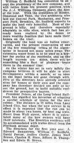
CBM tells us that he first determined to try and obtain land not too close to Shinnecock, but in the general area, within a few weeks of the time that the land was obtained by the Brooklyn Company, which was the fall of 1905.  CBM offered to purchase 120 acres near the canal, and the offer was refused.  The Brooklyn company was SHPBRC and they seemed to have other plans, because they immediately began developing the most accessible portions of their land, building roads and infrastructure soon thereafter.    But SHPBRC was apparently not immediately developing the entire parcel.  The map shows their development is on the Southern and Western portions which were more accessible, and not Sebonack Neck.   CBM tells us there were 450 acres on Sebonack Neck, and that he rode it, found he could use it, and they agreed to sell him some of it!   He went over it again and chose his land.    

Rather than rewriting the entire narrative, why don't you just step back and tell us where those Oct. 1906 articles best fit in this narrative?  They sure as hell don't fit with the 120 acres by the Canal.   The timing, size, and locations are wrong.  As is the result.    The fit quite nicely into the 450 acres that CBM secured a few months later.  

Yet you try to completely rewrite the entire narrative.  All because you haven't yet thought of a way to spin this earlier date to fit with your undying agenda?   So you keep trying to pretend that the land described in those articles was not the Sebonack Neck land.   This is preposterous.    The description fits, and by the fall of 1906, SHPBRC had been preparing their development on the land you claim he wanted for about a year!    You just ignore these realities because you want to keep alive your fantasy that CBM didn't stumble onto this land until the winter of 1906?   Absurd!

December 28, 1905.  Brooklyn Daily Eagle.

« Last Edit: February 14, 2011, 03:20:00 PM by DMoriarty »
Golf history can be quite interesting if you just let your favorite legends go and allow the truth to take you where it will.
--Tom MacWood (1958-2012)

Jeff_Brauer

  • Karma: +0/-0
Re: The Creation of NGLA in Chronological, Contemporaneous News Articles
« Reply #347 on: February 14, 2011, 03:12:54 PM »
David,

What was the exact date of that article you posted?

Its funny, but yes, Golf Grounds did apparently exist, but this article's "mistake" is listing the canal as the eastern boundary instead of the western boundary, unless there is another canal I don't see.

As to the road, it was there, but Olmstead and Vaux seemingly had no trouble rearranging it if the 1873 map is anywhere near accurate. However, it also appears that the Olmstead plan was not adopted at all.  Only the western half of North Highway looks to be the same, and most of the side streets have been straighten in actual development from the initial plan.

Mike,

I am still not sure from your last post if your blue line/red line plan earlier was meant to pin down where the first 120 acre offer was?  If the SHPB realty company had started planning in the western area - which makes sense since it was closer to roads, railroads and NYC, then they probably did reject CBM's offer easily, and sent him out to the unsurveyed, further from everything, harder to get utilities and roads to Sebonac Neck area.  Even then, and I am only speculating here, I suspect that rather than ground contours, the final 250 acres was not completely at CBM's disposal as he wrote. Most developers would limit water frontage knowing its value.

And, as CBM says, he didn't want to build a clubhouse, which someone was nice enough to build for him!  Limited water frontage, need to use the Shinnecock Inn, and an out and back routing simulating TOC seems like a match made in heaven to me.
Jeff Brauer, ASGCA Director of Outreach

DMoriarty

  • Karma: +0/-0
Re: The Creation of NGLA in Chronological, Contemporaneous News Articles
« Reply #348 on: February 14, 2011, 03:19:31 PM »
December 28, 1905.  Brooklyn Daily Eagle.
« Last Edit: February 14, 2011, 03:52:11 PM by DMoriarty »
Golf history can be quite interesting if you just let your favorite legends go and allow the truth to take you where it will.
--Tom MacWood (1958-2012)

Mike Cirba

Re: The Creation of NGLA in Chronological, Contemporaneous News Articles
« Reply #349 on: February 14, 2011, 03:45:06 PM »
David,

Golf Grounds Train Station did not exist in October 1906 at least according to the LIRR archives.   I see your article says it already existed in 1905, so they may be wrong.

They claim it opened in April 1907.
« Last Edit: February 14, 2011, 03:48:21 PM by MCirba »