I was doing a little reading and catching up on Sharp Park and thought Id post a thread regarding the lost 4th at Sharp Park
plus a little on the 8th. BTW, this is nothing new technically and anyone could have put this together on their own if they had the inclination and a little time on their hands. What is new is
the photo and thats because it did not become available really until after the essay from Richard and Bo had been posted.
Before I get started however, Id like to thank the kind folks over at the San Francisco Public Golf Alliance. In particular, permission was granted by Richard Harris to post this photo for this thread. The photo is on the SFPGA site itself and Id recommend checking the site sometime. There are other pertinent photos there as well:
http://www.sfpublicgolf.com/Another person Id like to thank is Daniel Wexler for bringing to our attention the 1941 aerial, because as you will see
it was an eye opener back then and even more so now. He even suggested its existence on the March 2003 interview! Finally, Sean Tully showed me previously what Ill call the plan and the map/routing some time and they are critical pieces I feel. I believe Tom MacWood might have posted the plan at one time or another as well. You can refer to the SFPGA site to see the plan and the work done by Jay Blasi for this. The map/routing is on Richard and Bos essay.
In a way, this thread piggybacks onto Richard and Bos essay and Im just providing another perspective I guess.
Onto the show
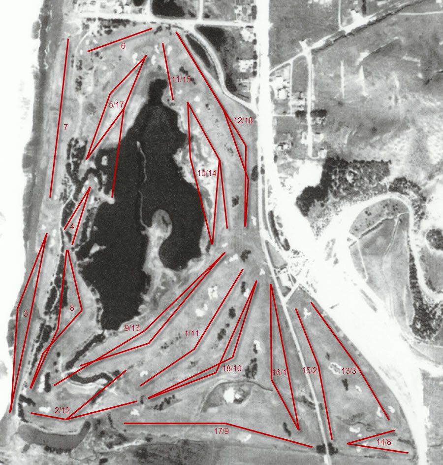
First, Id like to briefly go over the plan and the map/routing. I wish I knew for certain the dates to both, but it appears the plan dates back to when the course was being envisioned (e.g. 1930-31 or so?). The map/routing might be post construction, but could be prior. The reason Im suggesting this is because when you look at the plan and the map/routing side by side
youll find they are quite different. Especially in regards to the so called Lido design holes no.5 and no.10 and
how they would play. In fact, a good exercise is to compare the plan, the map/routing, and the Lido design hole side by side. This is perfect timing, because Sean has the following Lido thread going on right now that shows the Channel design hole from MacKenzie. Youll see the plan to be closer to the Lido design, while the map/routing departs a little
for the tees and angles of play in particular. You can argue which of the 5th or 10th comes closest to the submitted Lido design, but to me they look like two attempts at the same kind of Channel hole concept
except with two different tee shots in mind. The 5th calls for what would appear to be a fade whereas the 10th would be a draw. If youre the purist, I guess the 10th would be closest to the Lido submission:
http://golfclubatlas.com/forum/index.php/topic,46651.0/So I tried to figure out which one was more correct: the plan or the map/routing? My observation and therefore suggestion is simply this: the plan was just a plan. It was not based on what turned out to be actual. Certainly it was close, but I see the plan as what was envisioned and the map/routing as what turned out to be. The only possible exception I can think of that would prove my suggestion wrong is if between the time the plan was drawn and when the aerial from 1941 was taken that the course changed. I guess its always possible that with enough storm surging and/or tweaking / adjusting over the years that it could have changed. But I doubt this based on how holes no.5 and no.10 look like from the aerial. The other piece backing my suggestion up is if you try to overlay the plan and the map/routing against the aerial
youll find the plan doesnt fit anywhere near as well as the map/routing. In fact, the map/routing almost looks like a carbon copy of the 1941 aerial. It is that close. Even the humps, bumps, trees, bunkers, etc. on the map/routing mirror the aerial. Could the map/routing been derived from the 1941 aerial? Who knows, but they are awfully close. To show this, I took the time to overlay the map/routing on top of the aerial for the tees and lines of play. Please note two things from my rendering
One is Im missing a red segment to the line of play on what was hole 17 (todays 9th). I only show two segments instead of three. The 17th is a par 5. Also, I did not label what was the 7th hole as being todays 16th because technically it runs parallel now. Im sure someone with much better skills could do much more (like a transparent overlay of the aerial and the map/routing), but I think the point gets across:
1941 Aerial (Photo courtesy of Daniel Wexler)
Thoughts?
Notice how on the on the plan theres the suggestion of an immediate fairway option off the island like tee (off the right side of the 4th green) to the 5th hole. Do you see this in the aerial? Doesnt look like it to me.
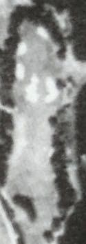
But this thread is intended to be about the 4th hole and to a limited extent the 8th. When I saw the 1941 aerial for the first time, I of course drew my immediate attention to the 5th and 10th to see what they really looked like. Sure they caught my attention, but the 4th really caught my attention as well (e.g. the bunkers really stand out). What a cool looking par 3! Notice how the 4th is also the only hole really bordered side and back of the green by trees. This is important because if helps confirm the photo youll see. Heres a closeup of the 4th from the 1941 aerial:
I then remembered how Richard and Bo mentioned in their essay how amongst the dunes the 4th was still there in some form. So I decided to take a look from above using a current Google map.
Placing the 1941 aerial side by side with the Google overhead and narrowing it down got me to the following:
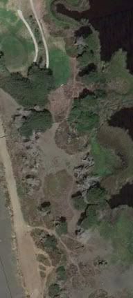
Low and behold
all of it is still there. Clearly whats left of the green is still showing.
Side by side now:
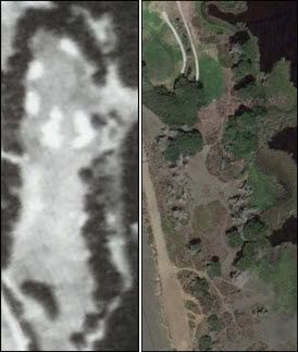
I had no idea how much of it was still there
Now to the photo
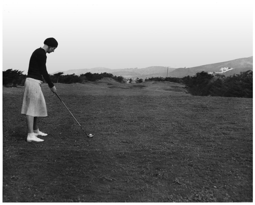
As I was saying, I was reading up and catching so it led me to the SFPGA and this is where I came across the photo of the women on a tee at Sharp Park in the 1930s. I immediately knew it had to be 4th because of the trees. What a revelation! Also, the Cypress trees shape to the wind and as you can see
they are shaped to an onshore wind, but coming from the left. This would tell you the hole is directed South to North. The only other par 3 on the course that could have qualified from the trees is the 2nd, but the trees would NOT be shaped as on the photo because the 2nd is head on and the 2nd does not present as many trees.
Woman Golfer On Sharp Park 4th Tee (Photo courtesy of SFPGA)
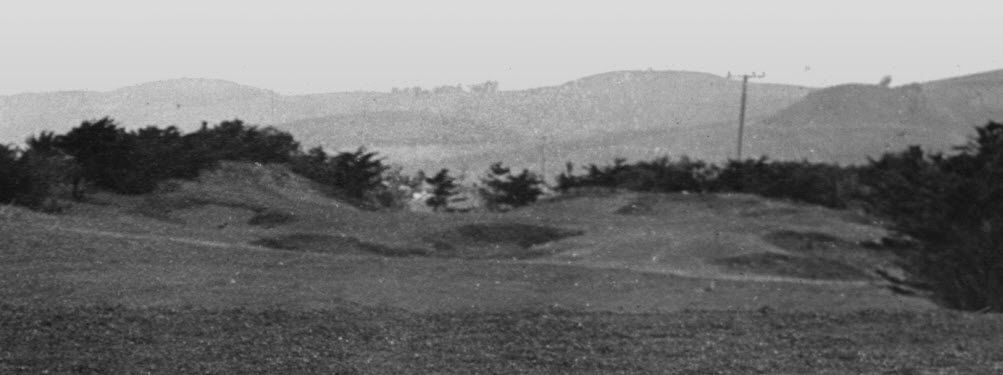
Finally, I had to blow up the green and surrounds to get a closer look at Egans work. Folks, I think for the GCA geeks this is an important find. To my knowledge, this is the first time Ive seen an actual hole from the original course. Ive never seen anything this clear posted on GCA or elsewhere. So there you have it
I think this also might back up some of what Tom MacWood stated in that the holes would NOT have been natural dunes. Rather, whatever was there would have been moved around. Plus keep in mind the dredging was mentioned and that could have been used in some fashion for shaping this hole. Who knows
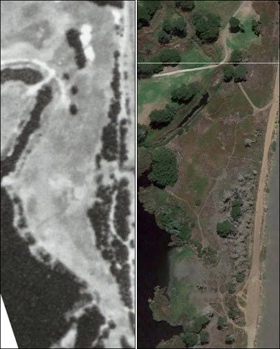
Ill cut to the chase now on the 8th, but again as mentioned by Richard and Bo
the left overs are still there. Just like for the 4th
the green shows. Heres the side by side to confirm this. Im not trying to make this an afterthought. Im just tired on banging out this post and I have no photo for the 8th unfortunately, but is sure looks like a cool hole:
I tried to do the same for the par 3 6th and Im convinced at this point that the green would have been somewhere between the edge of the burm and the beach. So its gone for good I think. Same thing goes for the 3rd obviously. Maybe a variation of the 7th could be done with where the 16th stands today, but it would not place correctly.
Having played Sharp Park many times
I have to say I agree with Richard and Bo that much of whatever was Sharp Park in the early days is sort of still there. The difference is much of it has been softened over time. Interpretive restoration for what is in place is not out of the realm of possibility I think. With the help of additional research, who knows what might turn up. Plus Sean needs to put something together at some point. I might start another thread in time regarding this and in particular focus on the holes closer to the clubhouse. We shall see.
Hopefully everyone finds this thread someone interesting or at a minimum entertaining. The beard pullers out there can discuss