News:

Welcome to the Golf Club Atlas Discussion Group!

Each user is approved by the Golf Club Atlas editorial staff. For any new inquiries, please contact us.


Charlie Goerges

  • Total Karma: 8
Let's learn how to read a topographic map
« on: July 30, 2009, 09:34:15 PM »
...Shall we?


The recent thread on routing left me wondering a number of things. Is routing some sort of mystical hoodoo that only the shamans of golf course design can fully comprehend? Is it pointless for we philogolsofers to even attempt to understand it?

My own answers led me to start this thread. I don't think it's impossible to understand, nor is it pointless. But in order to get a better idea of it, we who would like to understand it better will need to be able to read and understand a topographic map. I don't claim any degree of expertise in this area, I simply thought it better to light a candle than to curse the darkness. Therefore anyone who would like to correct me or expand on any of the information contained herein is most welcome and I thank you in advance.

Periodically over the next several weeks I'll provide ever more complex and complicated topographic maps for us to discuss. To start with, however, we'll look at a map whose concept I "appropriated" from the USGS and USC. It is one that was contained in some educational materials meant to teach the understanding of topographic maps. I'll attach the PDF of this document to the end of my post.

I encourage those who are interested to download the document and map and study it if they wish, perhaps even opening the jpeg image below and drawing or shading it in MS Paint or some such program with ideas as to the shape of the land.
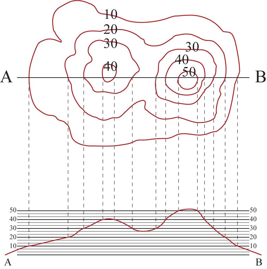


Just below I've depicted the contour lines shown above in the 3D program google sketchup. It is meant to give something of an idea of what the above would look like.
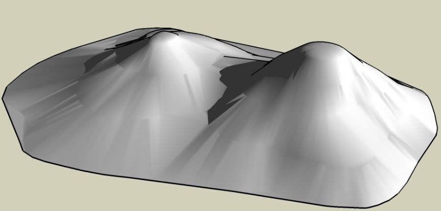


Again, feel free to comment, ask questions, or correct any assertions that I've made. Happy learning!
Severally on the occasion of everything that thou doest, pause and ask thyself, if death is a dreadful thing because it deprives thee of this. - Marcus Aurelius

Wayne_Kozun

  • Total Karma: 0
Re: Let's learn how to read a topographic map
« Reply #1 on: July 30, 2009, 10:01:08 PM »
Is it just me or does this look more like a lopsided pair of breasts rather than land suitable for a golf course?

Mike Nuzzo

  • Total Karma: 13
Re: Let's learn how to read a topographic map
« Reply #2 on: July 30, 2009, 10:07:29 PM »
Wayne - impossible to know without seeing how wide the parcel is - but it looks too steep
The elements that would be most interesting for a green feature are the tiny little ripples in the contours - you can only guess until you walk the area
Thinking of Bob, Rihc, Bill, George, Neil, Dr. Childs, & Tiger.

Steve Lang

  • Total Karma: 0
Re: Let's learn how to read a topographic map
« Reply #3 on: July 30, 2009, 10:11:31 PM »
Le duex tetons!

charlie.. rule #1  one has to draw perpendicular lines to the topo lines to define drainage paths
Inverness (Toledo, OH) cathedral clock inscription: "God measures men by what they are. Not what they in wealth possess.  That vibrant message chimes afar.
The voice of Inverness"

Joe Hancock

  • Total Karma: 5
Re: Let's learn how to read a topographic map
« Reply #4 on: July 30, 2009, 10:15:31 PM »
Charlie,

Thanks for using your talents to help us all further our ability to understand more about golf course design and construction....neat idea!

Joe
" What the hell is the point of architecture and excellence in design if a "clever" set up trumps it all?" Peter Pallotta, June 21, 2016

"People aren't picking a side of the fairway off a tee because of a randomly internally contoured green ."  jeffwarne, February 24, 2017

John Moore II

Re: Let's learn how to read a topographic map
« Reply #5 on: July 30, 2009, 10:18:52 PM »
Folks, before we critisize the look of the land, how about we step back for a moment and figure that Charlie was just trying to present a somewhat less than complicated example of how to look at a Topo map? I know how to read one and given about 2 minutes to study, could identify depressions, cliffs, rocks and any number of other things on the map. It is fairly complicated, but this drawing is likely an attempt to show how to look at the map and what the circles and lines on a flat, 2D map mean.

Chip Gaskins

  • Total Karma: 0
Re: Let's learn how to read a topographic map
« Reply #6 on: July 30, 2009, 10:24:36 PM »
Fantastic thread.  I recently played a course in Michigan everyone on this board loves and often starred off into the woods and wondered how they came up with the great routing.  Wondering specifically how to turn a tree filled topo map into a great routing.  Art!  not Science

Charlie Goerges

  • Total Karma: 8
Re: Let's learn how to read a topographic map
« Reply #7 on: July 30, 2009, 10:51:37 PM »
Indeed, JKM you are correct. The map is meant only to help explain the basic concept. The dotted lines extend down to a cross-section of the map along the line from A to B which depicts approximately what it would look like from the side.

I recommend downloading the PDF I attached if the map is at all confusing, also feel free to post questions or ideas as well. It is best to get a solid foundation before moving on to the complicated stuff. We will get to some topo maps of the real world eventually.
Severally on the occasion of everything that thou doest, pause and ask thyself, if death is a dreadful thing because it deprives thee of this. - Marcus Aurelius

Jeff Doerr

  • Total Karma: 0
Re: Let's learn how to read a topographic map
« Reply #8 on: July 31, 2009, 12:44:32 AM »
Thanks Charlie - I'll follow along!
"And so," (concluded the Oldest Member), "you see that golf can be of
the greatest practical assistance to a man in Life's struggle.”

Kalen Braley

  • Total Karma: -7
Re: Let's learn how to read a topographic map
« Reply #9 on: July 31, 2009, 01:42:08 AM »
Charlie....

I'm in too, this is good stuff, keep it coming!!

Bill Brightly

  • Total Karma: 0
Re: Let's learn how to read a topographic map
« Reply #10 on: July 31, 2009, 07:20:15 AM »
I agree that this is a great thread. I have always felt that I could "see" potential golf holes when looking at open land, and I do this all the time while driving or walking. But the ability to route from a topo map has always mystified me. My brother is a civil engineer and he has tried to explain it to me, but I still have no clue! Let's see if this works on a dope like me!

Lester George

  • Total Karma: 0
Re: Let's learn how to read a topographic map
« Reply #11 on: July 31, 2009, 09:41:08 AM »
Charlie,

Nice job.  Keep it up. 

Gentlemen,

Possibly the best (an most illustrative) book ever written regarding terrain reading and navigation is the the US Army's instructional manual on the subject.  I used it for years as an instructor and have used it to teach even the most two-deminsional of students.  I even threatened to use it on Tom Paul but someone has lifted my last copy. 

When I get a new one, I'll publish the the title and TM Number so all of you can order it.  It is really good as are most Army pubs.

Lester

JC Urbina

  • Total Karma: 2
Re: Let's learn how to read a topographic map
« Reply #12 on: July 31, 2009, 11:14:30 AM »
Charlie

Looked at your sample map and said to myself that is the 8th hole at the Valley Club. 

Lester George

  • Total Karma: 0
Re: Let's learn how to read a topographic map
« Reply #13 on: July 31, 2009, 11:36:13 AM »

Charlie,

Here is a link to the FM I was taliking about.  Enjoy.

http://www.globalsecurity.org/military/library/policy/army/fm/3-25-26/ch10.htm#par6

Lester

Charlie Goerges

  • Total Karma: 8
Re: Let's learn how to read a topographic map
« Reply #14 on: July 31, 2009, 01:02:23 PM »
Thanks Lester! That link will be helpful in providing a "lesson plan" for this little exercise.

Anyone who wants to read it and provide any tips or lessons, please be my guest.
Severally on the occasion of everything that thou doest, pause and ask thyself, if death is a dreadful thing because it deprives thee of this. - Marcus Aurelius

Dan Herrmann

  • Total Karma: 0
Re: Let's learn how to read a topographic map
« Reply #15 on: July 31, 2009, 01:06:43 PM »
I knew that college class I took in cartography would come in handy someday :)

Joe Hancock

  • Total Karma: 5
Re: Let's learn how to read a topographic map
« Reply #16 on: July 31, 2009, 03:26:23 PM »
Thanks to Lester, I can now be a better prepared sniper to take out DeVries on our next project......

(insert evil laugh)

Joey The Nose
" What the hell is the point of architecture and excellence in design if a "clever" set up trumps it all?" Peter Pallotta, June 21, 2016

"People aren't picking a side of the fairway off a tee because of a randomly internally contoured green ."  jeffwarne, February 24, 2017

Ben Sims

  • Total Karma: 11
Re: Let's learn how to read a topographic map
« Reply #17 on: July 31, 2009, 03:56:52 PM »
And I thought the only time I'd be reading one of these was survival and evasion....

Well done Charlie.

I will say that I find a useful technique to find the lowest point on the chart and mark it with a red dot and the highest point with a green dot. When I was a backpacking guide is helped explain to trekkers where the water probably would be. 

RJ_Daley

  • Total Karma: 1
Re: Let's learn how to read a topographic map
« Reply #18 on: August 01, 2009, 09:17:03 AM »
Anybody ever look at one of those stereoscopic 3-D aerials?  We had them in the lab in geography classes at the U.W. of many of the glacial morraine areas of Wisconsin.  Very cool. 
No actual golf rounds were ruined or delayed, nor golf rules broken, in the taking of any photographs that may be displayed by the above forum user.

Charlie Goerges

  • Total Karma: 8
Re: Let's learn how to read a topographic map
« Reply #19 on: August 01, 2009, 03:19:19 PM »
Okay folks, Below is the map that we're going to use for the majority of our "lessons". (it is "golfier" terrain than the last map) Remember, I'm not an expert, so I'll be learning right along with you. Any experts who would like to chime in are encouraged, nay begged, to do so.

Here is how it is going to work:
  • Participants will download the map by right-clicking it and selecting "save image" (or some other such command)
  • Said participants will open the map image in some sort of image editor software (Like MS Paint, photoshop, GIMP, Paint.Net etc.)
  • Participants will complete each "assignment" by marking on the image
  • When we've got through the initial run of assignments, participants will "hand-in" their homework by posting their file to the thread.

If you don't wish to do that stuff (or if no one wishes to do it) you can simply follow along, as at the very least I'll be completing all of the assignments.

A few words about the map. It represents an area about 415 yards wide by about 350 yards from top to bottom. There is a scale, 72 pixels equals 100 feet. Recognize that the scale is in FEET not yards as that is how most topo maps are.

Map:


The first assignment is a simple one so I've already completed it to show you how we'll mark up the map. Place 2 red marks at least a few hundred feet apart on spots that sit at the same elevation. See my image below for an example. Do be kind and don't choose exactly the same points as me!


Additional lessons will follow based upon Lester's link so if you wish to study up in advance please do so. Also, I'll be including snippets of that information for each of the following lessons. (I figured the first one was simple enough not to need much explanation.

Good luck!
Severally on the occasion of everything that thou doest, pause and ask thyself, if death is a dreadful thing because it deprives thee of this. - Marcus Aurelius

Steve Lang

  • Total Karma: 0
Re: Let's learn how to read a topographic map
« Reply #20 on: August 01, 2009, 10:49:17 PM »
 8) Charlie,

Can't we just jump to a 600/700 level course and design 4-6 full length holes or a par three course on that land ?

steve
Inverness (Toledo, OH) cathedral clock inscription: "God measures men by what they are. Not what they in wealth possess.  That vibrant message chimes afar.
The voice of Inverness"

Bill_McBride

  • Total Karma: 1
Re: Let's learn how to read a topographic map
« Reply #21 on: August 01, 2009, 11:53:35 PM »
Charlie

Looked at your sample map and said to myself that is the 8th hole at the Valley Club. 

Exaggerated, Jim, but I see what you mean!  You would bench a green in at about 45 feet on the higher hill, right?  It's really cool how much of the action at the Valley Club revolves around those two hills.

Charlie Goerges

  • Total Karma: 8
Re: Let's learn how to read a topographic map
« Reply #22 on: August 02, 2009, 12:07:58 AM »
8) Charlie,

Can't we just jump to a 600/700 level course and design 4-6 full length holes or a par three course on that land ?

steve


Steve,

You're welcome to, but I do want to go through the full process first. Remember this is for beginners, not veterans of design ;).

Severally on the occasion of everything that thou doest, pause and ask thyself, if death is a dreadful thing because it deprives thee of this. - Marcus Aurelius

Charlie Goerges

  • Total Karma: 8
Re: Let's learn how to read a topographic map
« Reply #23 on: August 02, 2009, 03:44:56 PM »
Okay, it's time for the first major lesson. I'm assuming that most people understand what a contour line is on a topographic map. But just in case here is the definition courtesy of the US Army:

Quote
A contour line represents an imaginary line on the ground, above or below sea level. All points on the contour line are at the same elevation. The elevation represented by contour lines is the vertical distance above or below sea level.

The contour interval is the vertical distance between each contour line. In the case of the map we're using, there is a 2 foot contour interval.

The closer together the contour lines are, the steeper the slope. The farther apart they are, the gentler the slope.

Here are some images from the US Army site.

Steep:


Gentle:


Common features can be readily identified if you know what you're looking for. Here are some example images from the US Army:


So now we come to the assignment. For this one identify as many ridges and hills as you can by marking their spines or high points with purple. Then mark valleys and saddles with the color blue. You know you're on a ridge if there is lower ground to at least 3 sides. You're in a valley if there is higher ground to three sides. See my example below (this is not exhaustive).


Good Luck!

Severally on the occasion of everything that thou doest, pause and ask thyself, if death is a dreadful thing because it deprives thee of this. - Marcus Aurelius

Jeff_Brauer

  • Total Karma: 4
Re: Let's learn how to read a topographic map
« Reply #24 on: August 02, 2009, 04:07:11 PM »
One trick in telling valleys from hills is to make sure you are looking at the contours facing "downhill" for that particular piece of topo.  (that is, the 104 contour is closer to you than the 102, then the 100, etc.)

If you are, a valley will look like a valley and a hill will look like a hill as if you were looking at it from ground level.  Charlie's purple and pink arrows are in a portion of the map where the ground runs downhill towards the top of the image, and they show up as expected.
Jeff Brauer, ASGCA Director of Outreach