News:

Welcome to the Golf Club Atlas Discussion Group!

Each user is approved by the Golf Club Atlas editorial staff. For any new inquiries, please contact us.


JESII

  • Karma: +0/-0
Re: Desmond Tolhurst's account
« Reply #550 on: August 17, 2010, 08:29:53 PM »
Jeff,

It's my understanding that the guys that owned the Johnson Farm land were the same guys that ran HDC, even if under a different name...The Philadelphia and Ardmore Land Company. Wouldn't this increase the likelyhoof of them being welcomed onto the property in hopes of becoming more interested in buying it? Afterall, HDC/Philadelphia and Ardmore now owned 345 acres on speculation that a golf course would increase lot prices on the remaining land.


Mike,

Your post there relies on the "approximate road" being a hard boundary before they went out to look for a golf course...and I fundamentally disagree with the notion that it was a hard boundary...regardless of when Francis' epiphany occurred.

JESII

  • Karma: +0/-0
Re: Desmond Tolhurst's account
« Reply #551 on: August 17, 2010, 08:55:01 PM »
Jeff,

Does it mean anything to you that the 14th green is 200 yards from the 13th green when every other transition, save one, was about 15 yards?

Mike Cirba

Re: Desmond Tolhurst's account
« Reply #552 on: August 17, 2010, 10:31:14 PM »


Mike,

Your post there relies on the "approximate road" being a hard boundary before they went out to look for a golf course...and I fundamentally disagree with the notion that it was a hard boundary...regardless of when Francis' epiphany occurred.


Jim,

Let me try this another way.

For the Francis "Land Swap" to make any sense at all, there had to be some type of fixed acreage or boundary they were working within.  Otherwise, if there were no defined limits, why the need to swap at all?   Why not just use whatever they needed?

Francis himself said, "We had some property west of the present course which did not fit in at all with any golf layout.   Perhaps we could swap it for some that we could use.   The land now covered with fine homes along Golf House Road was exchanged for land about 130 yards wide by 190 yards long - the present location of the 15th green and 16th tee.   Within a day or two the quarryman had his drills up where the 16th green now is today, and blasted the top off the hill so the green could be built as it is today."

That being said, I do think they had flexibility...within the constraint of 117 total acres.   

The problem is that the routing they worked up required them to purchase 120, which was three more than was presented to both the membership, as well as the investment community.   Francis needed Mr. Lloyd to agree to that number before they could proceed, and Lloyd as President of MCCGC as well as major stockholder of HDC was in a unique position to make that revision workable to both sides.

But here's the other problem with the literal interpretation of Francis as meaning the land of the triangle only...the math doesn't work.

The land of that triangle is only 4.8 acres.   

For it to be the only land that was swapped for, Merion would have theoretically only had to give back 1.8 acres tp HDC in return, and we know that's not true simply by looking at the large bulge of land across from the clubhouse that Merion gave back...the "land now covered with fine homes along Golf House Road."

I think they also gave back land north and west of the triangle, which is about another five acres.

The only way mathematically for this to work is to measure the puts and gets from whatever that original working boundary was, whether it matched the November 15, 1910 Land Plan, or whether it was based on a separate Topo map the Committee was working with by early February, and end up having to use 3 more acres than they were able to give back based on the original 117 acres they thought were under their control.

I'd suggest those acres, on both sides of the Francis "swap", or more accurately, the Francis "acquisition", were located up and down Golf House Road almost along its length, with the gets needing to equal 3 more acres than they were able to put back.

Nothing else makes any sense, mathematically at least.

JESII

  • Karma: +0/-0
Re: Desmond Tolhurst's account
« Reply #553 on: August 17, 2010, 10:46:41 PM »
Mike,

The most important thing you said there is in the first full paragraph...

"For the Francis "Land Swap" to make any sense at all, there had to be some type of fixed acreage or boundary they were working within.  Otherwise, if there were no defined limits, why the need to swap at all?   Why not just use whatever they needed?"

And more specifically, for the theory that it was several puts and gets up and down GHR, this fixed boundary had to be the "approximate location of road"...why would any of the parties involved require a hard boundary there? Why would they use, as a hard boundary for their 117 acre plan, a 124 acre area?

Mike Cirba

Re: Desmond Tolhurst's account
« Reply #554 on: August 17, 2010, 10:47:56 PM »
Jeff,

Does it mean anything to you that the 14th green is 200 yards from the 13th green when every other transition, save one, was about 15 yards?

Jim,

I know this question was addressed to Jeff, and I'm sure he'll answer, but personally I think it's just one of those quirks of the routing that was based on the limitations inherent with previous routing choices.

They had to start on the clubhouse side of the road, and also had the 10th and 11th holes cross the road to the clubhouse side, which used up almost all available room to get to the other side of the property north of Ardmore Avenue.  

They ended up squeezing the 12th green and par three 13th hole over along the side of the clubhouse, but then to give them any room at all to proceed up the hill they had to come left...otherwise they were looking straight back up the hill of today's 18th hole, only going in the opposite direction, ending about 250 yards away falling off the cliff into the quarry.   Probably not the best route, and probably pretty obvious.

In this picture we can see the original first hole, the old and new tenth greens, the old and new 11th tee, and the old and new 12th green.   The short par three 13th ran along the far side of the clubhouse, and to proceed from there really doesn't yield much because, as mentioned, you run into the quarry in about 250 yards.


This next picture is a bit more difficult to see, but if you follow along past 13th green, you can see that proceeding straight from there dead end's pretty quickly.

Instead, the only workable route is to go up left around the quarry, and then try to come back down the hill and use it where possible, but not as a blind hazard approached from below, but instead as a dramatic and visible hazard addressed from either above it, or from down within the quarry walls.

This picture fortunately, though, shows the puts and gets along Golf House Road very clearly, and really illustrates for me how the alternate fairway around the quarry on 16 pushes out the 14th green and 15th hole, with the give backs being the large stretch of homes along Golf House Road across from the clubhouse that Francis mentioned.


Jeff_Brauer

  • Karma: +0/-0
Re: Desmond Tolhurst's account
« Reply #555 on: August 17, 2010, 10:53:16 PM »
Jim,

Try substituting the phrase "working boundary" for "fixed boundary" and see if the process makes any more sense to you.  Perhaps they had agreed to 117 acres and just felt they needed to put something approximating that on the plan in November just to start the process out.  Everyone knew there was flexibility.

As to the long walk, it is awkward, but you have a fixed clubhouse location, the original entry road to the clubhouse and the first tee and putting green to contend with.  Maybe they explored (as one of the five routing) reversing those five holes, and making 18 no 14 playing in reverse, but felt 16 and 17 worked out better the way they ended up.  That sort of thing happens in routing.
Jeff Brauer, ASGCA Director of Outreach

Mike Cirba

Re: Desmond Tolhurst's account
« Reply #556 on: August 17, 2010, 10:54:23 PM »

Mike,

The most important thing you said there is in the first full paragraph...

"For the Francis "Land Swap" to make any sense at all, there had to be some type of fixed acreage or boundary they were working within.  Otherwise, if there were no defined limits, why the need to swap at all?   Why not just use whatever they needed?"

And more specifically, for the theory that it was several puts and gets up and down GHR, this fixed boundary had to be the "approximate location of road"...why would any of the parties involved require a hard boundary there? Why would they use, as a hard boundary for their 117 acre plan, a 124 acre area?


Jim,

If you have another theory, I'm all ears, but I'd say two things first.

1) We don't know if the Topo Map they were working with was 124 acres like the Nov, 1910 Land Plan, or 117 acres that they said they secured.

2) I'd really like to verify the measurements of that Nov 1910 Land Plan as indeed 124 acres, and am wondering if anyone has the ability to do that based on the scale map provided.   If someone needs a bigger blow up of the image to do that calc, I could certainly provide it to them.

Otherwise, I think I've answered a lot of your questions today and think if you have an alternative idea I'd love to hear it.  ;)

JESII

  • Karma: +0/-0
Re: Desmond Tolhurst's account
« Reply #557 on: August 17, 2010, 11:02:13 PM »
Alternative to what, Mike?

I've said all along that I think the Francis idea hatched because they had no land above the south end of the Haverford College / current driving range land...but they did have the land west of the clubhouse where homes actually sit.


Jeff,

Maybe I don't understand "wprking boundary"...how would they get stuck by a working boundary if all they needed was 20 or 30 yards, and had plenty to give back?

Mike Cirba

Re: Desmond Tolhurst's account
« Reply #558 on: August 17, 2010, 11:09:53 PM »
Jim,

If you look again at that last picture I've posted, can you possibly imagine them routing the first 13 holes if they only had the land below the south boundary of Haverford College at their disposal for the final five of their championship course?   Seriously, they'd have to be a little nuts, wouldn't they?   That would have been nothing but an exercise in futility...there isn't really land left for more than 3 good holes, much less five.

That 20 to 30 yards shy in width wasn't just at one fixed point at the bottom of the triangle, but along the entire left side of the  15th hole and along the entire 14th green and some of the top of that hole.

That was the problem, not just trying to fit in the 15th green/16th tee.


Jeff_Brauer

  • Karma: +0/-0
Re: Desmond Tolhurst's account
« Reply #559 on: August 17, 2010, 11:12:28 PM »
I don't think they were stuck at all.  They (or the surveyor) picked a general boundary, as per the Nov 1910 plan.  They knew they could move the road as necessary.

As I said, I think the Francis recall of the event many years later was told in dramatic voice.  Basically, he was the one who realized how the parcel needed to be reconfigured to get the six holes in and stay close to the 117 acres.  Apparently, he was most creative at night!

Given the record shows that they had some routings by March 1911, and five more after, to me the only question is when did the reconfigurtion take place within that time frame?  It would seem to be that the idea hatched before going to CBM, and he helped them make the best use of the flexible boundary when they were at NGLA, but it could have happened after.  I guess that would make it a sixth plan, eh?
Jeff Brauer, ASGCA Director of Outreach

TEPaul

Re: Desmond Tolhurst's account
« Reply #560 on: August 17, 2010, 11:19:13 PM »
"Jeff,
Does it mean anything to you that the 14th green is 200 yards from the 13th green when every other transition, save one, was about 15 yards?"


Sully:

I just got in---I haven't read any of the previous posts in the last six hours and I'm also sort of worn out and semi-wasted after the most interesting green committee meeting I've ever been to but I think you must have meant--was the old 13th GREEN 200 yards from 14th TEE!  ;) I would say it was about 200 yards from the 14th tee if you hit the ball from the old 13th green either through the clubhouse or over it!!  ;)

JESII

  • Karma: +0/-0
Re: Desmond Tolhurst's account
« Reply #561 on: August 17, 2010, 11:19:52 PM »
Those two posts make an interesting point...maybe the Francis Swap is sensationalized in his remembrances, and that there really was little excitement surrounding the solution. That hadn't occurred to me.

JESII

  • Karma: +0/-0
Re: Desmond Tolhurst's account
« Reply #562 on: August 17, 2010, 11:27:30 PM »
Regarding the dilemna of actually needing an extra 3 acres on the re-measurement...they did pay retail...or at least agreed to pay retail...so I don't see the significance in it being any concern.

Mike Cirba

Re: Desmond Tolhurst's account
« Reply #563 on: August 17, 2010, 11:30:50 PM »
Jim,

Do you think Francis had the power to unilaterally add three acres to the golf course and away from the real estate component that Mr. Lloyd had represented to the MCC membership and to the Investment community as 117 acres being purchased at a fixed price of $85,000 for golf, and the 221 acre remainder for adjacent real estate development, or do you think he needed to clear that through Lloyd and also get the subsequent approval of the MCC Board of Governors?

p.s.   Good discussion today...I'm not sure we're closer to agreement, but I think we've at least both made our points clearly.   Perhaps we can pick up any areas for further discussion tomorrow.   Thanks.
« Last Edit: August 17, 2010, 11:33:32 PM by MCirba »

JESII

  • Karma: +0/-0
Re: Desmond Tolhurst's account
« Reply #564 on: August 17, 2010, 11:39:05 PM »
Agreed Mike...I look forward to it.

Your question about Francis unilaterally adding land perfectly illustrates my inability to explain what I think.

I think the added 3 acres was the result of a roughly drawn "approximate road" AND an incomplete plan at the precise point in time that the map was drawn. I've consistently used the term "informal routing" to describe what I think the team had accomplished prior to the map being developed. The correct term is probably a stick routing with little or no consideration to width. An example of this is the 100 yard width at the base of the Haverford College land...based on a stick routing and inexperience, who wouldn't think they could get two holes into a 100 yard width?

Mike Cirba

Re: Desmond Tolhurst's account
« Reply #565 on: August 18, 2010, 09:34:12 AM »
Jim,

I understand what you’re saying and I truly don’t think we’re too far off, but I think we still differ slightly about what problem we see the Francis Swap/Acquisition solving and when.   At least now we both seem to think it was to solve the problem of not enough width!  ;)

I do agree with you conceptually that these guys were out there prior to January, and anyone who has ever walked a property being considered for golf would either have to be brain-dead or a complete creative dullard to not envision particular golf holes, whether or not they are feasible, or even would be any good, or whether they'd fit together in an 18 piece jigsaw puzzle.   And that natural early envisioning of golf holes is a big part of the problem I have with the idea that these guys decapitated the northern end of the Johnson Farm during initial negotiations, because then it becomes harder to imagine how they might have still ended up with a reasonable 117 acres for golf, or even how they may have imagined using 120 back in July when all they/HDC owned was the Johnson Farm.  

What’s more, the idea of walking the property and envisioning golf holes leads me to believe that of any spot they might have considered, the view from up on the hill by today’s 15th green/16th tee down across the quarry would have been inescapable to almost anyone.   It is wonderfully dramatic, and I can’t believe they would march down to within 130 yards of the quarry at the south end of the Haverford College boundary, draw an artificial line and say, and say, “let’s start here”.    As inconceivable as it is to you that they wouldn’t have been out there fiddling around with where they could put golf holes prior to January 1911, I have the same incredulity to think they would have created an artificial boundary just where it was obvious that greatness could be achieved.

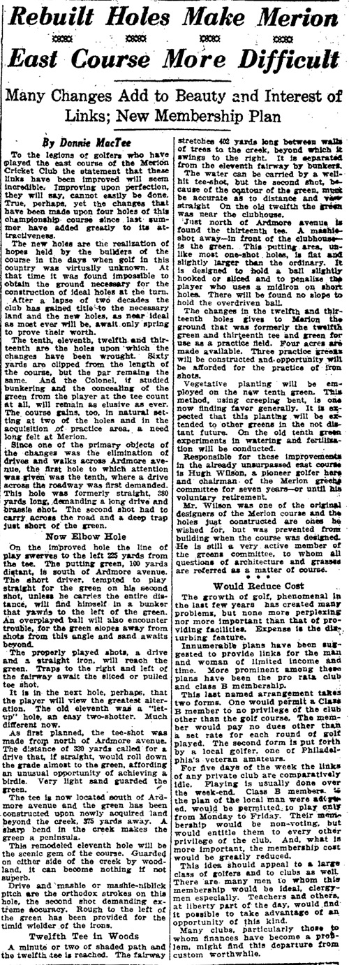
I used to wonder the same thing about the lower part of today’s 11 and 12.   How could these guys have been out there and leave themselves only about 250-300 yards to work with between Ardmore Avenue and the bottom of the hill, especially with that beautiful creek flowing through the area; another pretty obvious place to put golf holes, and another dramatic, almost natural amphitheatre setting.   Why of course the Johnson Farm ended too abruptly down there, but surely they could have negotiated for another few acres, right?   After all, it seems the alternative was to have to cross Ardmore Ave. with three holes.

I saw this as a missed opportunity that I scratched my head about until very recently when Joe Bausch found the following article from 1922 by the writer Donald McTee, who also wrote under the name J.E. Ford, and who did a series of historic origin articles later concerning most of the prominent clubs in the Philadelphia area.   The article is a beauty, and makes a number of things very clear.

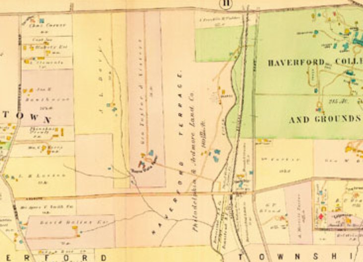
In looking at this map from 1908, prior to the purchase, one can not only see the wonderful hilltop peninsula promontory of the Johnson Farm to the north, which I can’t believe they would summarily decapitate, but also see the land mass in light orange below, which was the 126 acre estate of one John Marshall Gest.   Apparently, the club did try to negotiate for some of this land, to no avail.   This, and the negotiations for the Dallas Estate, may have been some of the reasons that not much activity took place between July and November of 1910.  


Finally, given your interpretation of the Francis Swap/Acquisition, I’m curious why you think they’d need to “give back” any land at all?   If they weren’t working with some reasonably firm or “working” boundary, and an additional 3 acres wasn’t much matter to them, why would they need to trade back land “already purchased”, as per the MCC Meeting minutes, and as per Francis’ account where he refers to the give back of the land across from the clubhouse to facilitate the beautiful homes along Golf House Road?

I do agree with you that the area on whatever map they were using ended up being too narrow for their needs, which to me meant they needed to grab an additional net three acres, as well as give back the parts they weren’t using to facilitate the adjustment to the original deal.   I just think most of the evidence points to that particular swap of land happening in the March/April timeframe of 1911, and not prior.   I think they had part of that upper part of the Johnson Farm in their plans all along, even if they made it too narrow at 100 yards at the base originally.

Hope that helps.


« Last Edit: August 18, 2010, 09:43:06 AM by MCirba »

TEPaul

Re: Desmond Tolhurst's account
« Reply #566 on: August 18, 2010, 12:04:50 PM »
"And more specifically, for the theory that it was several puts and gets up and down GHR, this fixed boundary had to be the "approximate location of road"...why would any of the parties involved require a hard boundary there? Why would they use, as a hard boundary for their 117 acre plan, a 124 acre area?"


Sully:

This is the kind of detail I hate to see get used in a really careful analysis and discussion of an event that took place about a century ago, and particularly when anyone begins to consider the detail as some fact back then. Who back then ever said or wrote or even implied that area in green on that Nov. 1910 Land Plan of the proposed golf course was an 124 acre area?

I think that number may've appeared in an historical analysis of Merion East for the very FIRST TIME when somebody on this website attempted to measure that area with something like a Google Ruler off some photograph of that Nov. 1910 land plan. I think that (the 124 acre area idea) first happened on this website last year.  ;)

Mike Cirba

Re: Desmond Tolhurst's account
« Reply #567 on: August 18, 2010, 12:42:48 PM »
Tom,

I don't recall where that 124 acre estimate for the Non 1910 Land Plan came from originally.

I do know the accompanying circular solicitation letter to members said it represented the 117 acres Merion had secured at that point.

I'll see what I can dig up.

JESII

  • Karma: +0/-0
Re: Desmond Tolhurst's account
« Reply #568 on: August 18, 2010, 12:46:22 PM »
Tom,

You have to admit, however little you like these types of analyses, that your "put and get" theory is dependent upon that "approximate road" being the hard boundary, right? I say that simply because your puts and gets, as illustrated by Mike, are putting and getting from that exact boundary.


Mike,

Would you agree that #16 presents a very stiff challenge to carry the quarry with second or third shots for the majority of golfers today? If so, would you agree that the vast majority of golfers in 1912 would have seen it as an ocean to carry? Afterall, that seems to be the basis for the development of the route around.  Would you also agree that the carries on #17 and #18 are longer than on #16, and therefore, probably more challenging?

In that context, does it make sense that they MIGHT have initially been viewing the quarry, and its value for creating dramatic golf holes, as a lateral type feature...in other words, my theory doesn't rely on these guys looking at the quarry as we do today, and you are presuming upon them 100 years ago. It relies on utilizing the quarry alongside some of these holes.

Mike Cirba

Re: Desmond Tolhurst's account
« Reply #569 on: August 18, 2010, 01:47:38 PM »
Jim,

I’m not sure if I agree.  On the 16th, a par four (although the following illustration marks it as a five erroneously) of over 430 yards, a drive of say 250 would leave the player with an uphill approach, almost all carry, of 180 yards, which was a considerable carry at that time.


By contrast, although over 200 yards, the 17th played/plays dramatically downhill from the top cliff of the quarry.   Further, the area of the quarry was much more maintained at that time compared to today (Tillinghast complained it was a trifle too tidy, to much like a “Dutch housewife’s kitchen”), so I don’t think it was as scary a shot.


The 18th would have been a frightening bit, and a hole where one would need to keep their head down lest risk disaster, but I still think the approach on the lengthy 16th would have been the most fearsome to players with hickory and the new Haskell ball.


From behind the 17th green, you get a good look at what the carry on 18 would look like, with a tee to the left and forward a bit.


Jim,

By the way, did you see my question to you above concerning swapping for "adjacent land" as reference in the minutes as well as Francis' account?

I would agree that the puts and gets needed to be along something defined as a working boundary, whether consistent with the Nov 1910 Land Plan, or a Topo map they developed around the same time.

p.s.   Do you recall who came up with the measurement of 124 acres for the 1910 Land Plan?
« Last Edit: August 18, 2010, 01:56:19 PM by MCirba »

JESII

  • Karma: +0/-0
Re: Desmond Tolhurst's account
« Reply #570 on: August 18, 2010, 02:14:57 PM »
Mike,

On 16 you'd have the option to lay up in front of the quarry and have to hit it 100 - 120 yards in the air...much less than the minimum for 17 or 18...but regardless, the meat of my question was that all three are daunting, so daunting in that day that it seems very reasonable to me that they were intially looking to use the quarry as a lateral feature instead of its present form being a carry obstacle.

JESII

  • Karma: +0/-0
Re: Desmond Tolhurst's account
« Reply #571 on: August 18, 2010, 02:16:19 PM »
Also - I don't know what question on the "adjacent land" you're referring to...I'll go read his words again, but what was your question?

JESII

  • Karma: +0/-0
Re: Desmond Tolhurst's account
« Reply #572 on: August 18, 2010, 02:34:00 PM »
I think I see what you mean..."why would they have to give back any land at all if they didn't have a working boundary to begin with?" Is that the question?

My mistake was in not elaborating on the question...what I am really curious about is why they would agree to buy 117 acres and have 4 or 5 of them committed to an area that would prove to be unusable because it was too narrow...without ever considering golf on it? This triangle was too narrow in the form on the map.

I assume they were working against a hard line with the sole reason being that a soft line/working boundary couldn't have caused the dilemna described by Francis (Jeff, if we throw out the "dilemna" as being simply a dramatic voice 40 years after the fact and we agree that the swap wasn't actually for the land 15 green and 16 tee are on, what was he truthful about?).

I then assume the initial goal for the developers would be to keep the golf course (above Ardmore Ave) around the quarry as much as possible.

Then, it seems realistic to me to "decapitate" the Johnson Farm at the Haverford College land BEFORE they ever looked for golf holes. This seems reasonable because every other property line on those old maps were straight lines...not the attractive curving line you see after the fact.

JESII

  • Karma: +0/-0
Re: Desmond Tolhurst's account
« Reply #573 on: August 18, 2010, 03:11:11 PM »
Regarding what Hugh Wilson has said in these articles and meeting notes.

In his first correspondence to the board - through golf chairman Richard Lesley in March 1911 - he summarizes what they had done in the field up to that point. He doesn't place a beginning date on it I don't believe. Those of you espousing the March - April timeframe for all work, I would ask you to look again at what he wrote regarding work done up until his first report. It certainly doesn't suggest they had only just done the work, and does allow that they may have been doing it for several months.

TEPaul

Re: Desmond Tolhurst's account
« Reply #574 on: August 18, 2010, 04:43:07 PM »
"Tom,
You have to admit, however little you like these types of analyses, that your "put and get" theory is dependent upon that "approximate road" being the hard boundary, right? I say that simply because your puts and gets, as illustrated by Mike, are putting and getting from that exact boundary."


Sully:

That's true, a swap and 3 acre addition would depend on a hard boundary for that approximate road. We just don't know if it was the same configuration on the contour survey map they were using in 1911 as it was on that Nov. 1910 Land Plan and I don't know if that Land Plan is measurable by us to accurately determine if it actually enclosed 117 acres in green or something else. I think it may've been Bryan Izatt on here who said he measured the green area on that Nov. 1910 Land Plan at 124 acres.

Tags:
Tags:

An Error Has Occurred!

Call to undefined function theme_linktree()
Back