News:

This discussion group is best enjoyed using Google Chrome, Firefox or Safari.


Bryan Izatt

  • Karma: +0/-0
Re: My attempt at the Timeline
« Reply #1550 on: June 13, 2009, 03:23:41 AM »
Mike,

Re your question

"Could you explain your last sentence about Tom's mathematical machinations or at least refer me to the particular post?"

I was referring to the eureka moment that Tom (and you, later) was pushing in mathematically deducing what was in the 117 and 120 acres.  It's embodied in the post below, although he presented it multiple time going way back to posts #652, 656 and 670.  I've added the correct numbers in red to highlight how the math should have been done.  The error is the opening assumption that the Johnson land never considered for the course (what I've labeled Area RE) was 23 acres.  It's not - it's 21.1 acres.  Based on that false assumption, the rest of the analysis falls apart.


"***EDIT*** I just went back and see that Bryan Izatt measured the land of the Johnson Farm north of Ardmore Ave. but west of Golf House road at 22 acres.   The Johnson Farm itself was just over 140 acres, which means if the original HDC offer was simply for the portions south of Ardmore Avenue, and the northeast section above Ardmore Avenue, that would be around 118 acres total.

I'm not sure if this is relevant, but it is certainly possible that this is the portion of land M&W were asked to consider and report on. (drawn crudely in black)"


You're not sure if it's RELEVENT??

Of course it's relevent! All one needs to do is follow the timeline of what MCC and HDC were doing from around July 1910 to about the middle of December 1910 to understand just how relevent it really is. Whether they had their eye on the Dallas Estate in June or July 1910 or whether they didn't the fact is when the Dallas Estate was finally nailed down by HDC around the beginning of Nov. 1910 that is practically the same day and certainly the same week Lloyd and Connell completed their negotiations and the actual formal offer was made by Nickolson to Evans through Lloyd and MCC's board voted on it and accepted the offer to purchase 117 acres!!

Then when MCC came in with their working topo contour maps (probably in the end of Dec or beginning of Jan 1911) with that proposed road drawn on the map to scale that they used to route and design numerous courses and plans on throughout the winter and early spring of 1911, one needs to realize that the land to the west of that road and between the western boundary at the top of the "L" of the old Johnson farm was approximately 21 acres that I said back on post #652, 656 and 670 I am convinced it was!

As I said in those posts back there:

23 acres=the western section of the old Johnson farm never considered for golf  Tom assumed it was 23 acres.  It's not, it's 21.1 acres
140.137 acres=the entire Johnson farm
140-23=117 acres  140.137 - 21.1 = 119.037

Remove that app 21 acres (Another false assumption, it now measures to be 19.8 acres)  from the 117  (really should be 119.037, as above) I mentioned on posts #652, 656, and 670 of the old Johnson farm to the west of the proposed road from the course plan (as it was on their working topo survey maps);

117-21=96 acres   119.037 - 19.8 = 99.237 acres

ADD the Dallas estate (21 acres  Deeded as 21.02 acres)

96+21=117 acres   99.327 + 21.02 = 120.347 acres

ADD the exchange AND 3 acre additional purchased acres to the golf course land via the Francis fix idea gotten along the extension of Golf House Road through it's redelineation from the working topo survey maps to its actual metes and bounds "as built" delineation (Thompson Resolution)----I've been saying this for over a year now!

117+3=120.1 acres of the July 21, 1911 deed from Lloyd to MCCGA   120.347 + 3 = 123.347 acres   Oooops, wrong answer!  It's not the 120.01 acres on the July 21, 1911 deed from Lloyd to MCCGA.  The flaws are in the original assumption, by Tom, that the Johnson Estate land never considered for the golf course was 23 acres, and the assumption that the land west of GHR to the western boundary of the Johnson Farm was 21 acres.  Neither were as assumed by Tom.  Perhaps that was why he wanted to sell me his methodology and why he didn't want to share the deeds and metes and bounds.  Hope that helps, Mike.


THIS is why I said in posts #652, 656 and 670 that when the metes and bounds of Golf House Road are measured with and enclosed with that old Johnson boundary (after the Francis fix) the area in there is no longer app 21 acres BUT 18!! (posts #652, 656 and 670!)


(of course if the road actually crossed over the old Johnson farm western boundary at the top of the "L" and into the Taylor estate a professional surveyor can easily find the small remainder).


There is no question in my mind what this serves to do is set that Francis idea and fix inside at some point the TIMEFRAME of Dec. 19, 1910 AND April 19, 1911 (but much more likely before April 6, 1911) and it is all reflected in the July 21, 1911 deed from Lloyd to MCCGA. If it happened before that none of this makes any sense and I guarantee you when a professional surveyor does these metes and bounds measurments THEY WILL match my incremental results above of 21 and then 18!

I've been saying this for 2-3 weeks and so far no one seems to understand it. This is the only place a boundary adjustment could have happened and the Francis boundary adjustment is the only one ever mentioned in this timeframe so it is the only one that could've happened in this timeframe! If Bryan measures the right boundaries and he measures well I'm convinced he will come to the same results. But if he does he still may not quite understand what it really means! We'll see.


Bryan,

I think I know what happened.

Your correction of Tom's numbers needs a slight correction, as well.

Tom adds in 3 acres as his last calculation, but those three acres need to be subtracted from somewhere else first, because it was ALL land along the division between the Golf Course and Johnson Farm land on RW that we're talking about.  

That would mean that prior to the "swap", the land marked "JW" would have been not 19.8 acres, but 22.8 acres, as the golf course at that time before Mr. Francis and his brainstorm was only 117 acres as determined in November 1910 and not the 120 acres it was built as (plus an additional 3 acres of leased railroad land not included in this calculation).   

We also know that Hugh Wilson's Committee report of April 19th, 1911 asking for approval of a land swap for land ALREADY PURCHASED for land adjoining AND approval for the purchase of three more acres for $7,500 was presented at a Merion Board meeting.

I think your numbers prove that swap/purchase had to be along Golf House Road, and I think we all also now know that this was indeed the Francis Land Swap..


So, with great appreciation and thankfulness for everything you've done here, Bryan,  I think the calculations should be;

23 acres=the western section of the old Johnson farm never considered for golf  Tom assumed it was 23 acres.  It's not, it's 21.1 acres CORRECT

140.137 acres=the entire Johnson farm
140-23=117 acres  140.137 - 21.1 = 119.037 CORRECT

Remove that app 21 acres (Another false assumption, it now measures to be 19.8 acres)  from the 117  (really should be 119.037, as above) I mentioned on posts #652, 656, and 670 of the old Johnson farm to the west of the proposed road from the course plan (as it was on their working topo survey maps); No, it is not 19.8 acres.  At that time prior to the 3 acre swap of land on that side of Golf House Road it would have been 22.8 acres

117-21=96 acres   119.037 - 19.8 = 99.237 acres This should be corrected to read 119.037 - 22.8 = 96.237

ADD the Dallas estate (21 acres  Deeded as 21.02 acres)

96+21=117 acres   99.327 + 21.02 = 120.347 acres This should be corrected to read 96.237 + 21.02 = 117.347

ADD the exchange AND 3 acre additional purchased acres to the golf course land via the Francis fix idea gotten along the extension of Golf House Road through it's redelineation from the working topo survey maps to its actual metes and bounds "as built" delineation (Thompson Resolution)----I've been saying this for over a year now!

117+3=120.1 acres of the July 21, 1911 deed from Lloyd to MCCGA   120.347 + 3 = 123.347 acres. This should be corrected to read 117.347 + 3 = 120.347..


With your agreement, I think we've figured this out.

What do you think, Bryan?


Mike, I think it was originally convoluted and is more so now.  So let me try to simplify it.


On November 15, 1910, HDC obtains 21.02 acre Dallas Estate through a series of flips.  At that date the Philadelphia & Ardmore Land Company owns the Johnson Farm of 140.137 acres. 

On November 15, 1910 the Board of Governors of MCC write a letter to the members outlining the results of "The Committee"'s search for land for the new course.  The Board announces that "The Club has secured 117 acres at $726.50 an acre, or $85,000."  There is no real estate transaction that reflects this "securing".   

With the letter, written on November 15, 1910 by the Board of Governors of MCC, was enclosed a "plan of the property".  The plan of property was prepared by Pugh & Hubbard, Civil Engineers.  It is further noted that the Board proposes to form a Corporation "which will buy outright, the 117 acres, shown on the plan in green, and marked "Golf Course".  (I'll address the acreage shown on the plan of property in a separate thread.)

On December 23, 1910, the Dallas Estate and the Johnson Farm are separately sold to Rothwell.  On December 28, 1910, the two properties are sold by Rothwell to Lloyd as a single entity of 161 acres.  The Indenture describes the metes and bounds of the survey conducted by Pugh & Hubbard, Civil Engineers.  So, the same surveyor did both the plan of property and the survey for the deed.

So, at this point MCC feel they have secured 117 acres and that that is shown on the plan of property.  How they got to 117 acres from 161 is through the subtraction of the fat L of land that I've labeled Area RE, north of Ardmore and west of GHR, and the land west of the "approximate" road between Ardmore and College that I've labeled Area JW.  We have three knowns:  the total acreage going in - 161.147;  the Area RE acreage - 21.1; and, the MCC "secured" acreage supposedly shown on the plan of property - 117.  We have one unknown - Area JW.  Solving the equation yields the area JW as:  161.147 - 21.1 - JW = 117.  JW = 161 - 21.1 - 117 = 23.047 acres.  There is no documentary evidence, other than the plan of property, the would define where the "approximate" road was that defines the AREA JW acreage.

Sometime between December 1910 and July 1911 another 3 acres was added to the 117 acres "secured" by MCC to arrive at the 120.01 acres that MCCGA finally purchased on July 26, 1911.  Given that MCCGA picked up an $85,000 mortgage for the 120.01 acre purchase and that the MCC Board letter sets the price at $85,000 for 117 acres, I think we can assume that they didn't "purchase" the extra 3 acres.  Somebody, presumably Lloyd, threw it in for free.  I think we can assume that the extra 3 acres didn't come from a like-for-like swap, since they added 3 acres and didn't give anything up.

Since there is no record of the metes and bounds of the 117 acre "secured" tract, the only evidence we've got as to where it was, is the plan of property, which, sadly is distorted.  The good news is that it was done by the same surveyor as did the deed survey a month later, so I'd guess they were familiar with the land and surveying it.  I think we need a flat scanned version of it to see if it really is to scale.  In response to your lost question about the acreage on that plan, Mike, I'll follow up with another thread tomorrow.

With regards to Tom's "conclusions" or what you've "figured .... out" above, I don't even want to go there yet.


Mike_Cirba

Re: The Merion Timeline - Now with Metes & Bounds
« Reply #1551 on: June 13, 2009, 09:08:16 AM »
Bryan,

Thanks for adding all of that back in.

I thought I should mention that I'm in complete agreemment so far.

I would ask, though, rather than starting a new thread, if you might perhaps post it here so that this thread reflects that search for the answer to this mystery based on the timelines.

Whatever you think is best...thanks again.

Tony_Chapman

  • Karma: +0/-0
Re: My attempt at the Timeline
« Reply #1552 on: June 13, 2009, 09:57:56 AM »
Bryan -- This is wonderfully done. Thanks! I'll make some comments below.

On November 15, 1910, HDC obtains 21.02 acre Dallas Estate through a series of flips.  At that date the Philadelphia & Ardmore Land Company owns the Johnson Farm of 140.137 acres.  

On November 15, 1910 the Board of Governors of MCC write a letter to the members outlining the results of "The Committee"'s search for land for the new course.  The Board announces that "The Club has secured 117 acres at $726.50 an acre, or $85,000."  There is no real estate transaction that reflects this "securing".  Absolutely correct. Remember, Lloyd still has control of the boundaries and I think he is acting in the best interest of both parties during this timeframe. Both the golf course and HDC.

With the letter, written on November 15, 1910 by the Board of Governors of MCC, was enclosed a "plan of the property".  The plan of property was prepared by Pugh & Hubbard, Civil Engineers.  It is further noted that the Board proposes to form a Corporation "which will buy outright, the 117 acres, shown on the plan in green, and marked "Golf Course".  (I'll address the acreage shown on the plan of property in a separate thread.)

On December 23, 1910, the Dallas Estate and the Johnson Farm are separately sold to Rothwell.  On December 28, 1910, the two properties are sold by Rothwell to Lloyd as a single entity of 161 acres.  The Indenture describes the metes and bounds of the survey conducted by Pugh & Hubbard, Civil Engineers.  So, the same surveyor did both the plan of property and the survey for the deed. I didn't know this. Apparently, you think by having this indenture, you might be able to show us how much land it really was?

So, at this point MCC feel they have secured 117 acres and that that is shown on the plan of property.  How they got to 117 acres from 161 is through the subtraction of the fat L of land that I've labeled Area RE, north of Ardmore and west of GHR, and the land west of the "approximate" road between Ardmore and College that I've labeled Area JW.  We have three knowns:  the total acreage going in - 161.147;  the Area RE acreage - 21.1; and, the MCC "secured" acreage supposedly shown on the plan of property - 117.  We have one unknown - Area JW.  Solving the equation yields the area JW as:  161.147 - 21.1 - JW = 117.  JW = 161 - 21.1 - 117 = 23.047 acres.  There is no documentary evidence, other than the plan of property, the would define where the "approximate" road was that defines the AREA JW acreage. Don't we really have only two knowns if we are unsure that the "secured" acreage is, in fact, 117 acres.

Sometime between December 1910 and July 1911 another 3 acres was added to the 117 acres "secured" by MCC to arrive at the 120.01 acres that MCCGA finally purchased on July 26, 1911.  Given that MCCGA picked up an $85,000 mortgage for the 120.01 acre purchase and that the MCC Board letter sets the price at $85,000 for 117 acres, I think we can assume that they didn't "purchase" the extra 3 acres.  Somebody, presumably Lloyd, threw it in for free.  I think we can assume that the extra 3 acres didn't come from a like-for-like swap, since they added 3 acres and didn't give anything up. Absolutely, agree with this statement. Again, it's my contention that Lloyd probably thought Francis' proposal about widening the golf course would give his HDC more golf course frontage.

Since there is no record of the metes and bounds of the 117 acre "secured" tract, the only evidence we've got as to where it was, is the plan of property, which, sadly is distorted.  The good news is that it was done by the same surveyor as did the deed survey a month later, so I'd guess they were familiar with the land and surveying it.  I think we need a flat scanned version of it to see if it really is to scale.  In response to your lost question about the acreage on that plan, Mike, I'll follow up with another thread tomorrow.

With regards to Tom's "conclusions" or what you've "figured .... out" above, I don't even want to go there yet.

Again, Bryan, hell of a job of putting these facts together.
« Last Edit: June 13, 2009, 10:14:07 AM by Tony_Chapman »

Mike_Cirba

Re: The Merion Timeline - Now with Metes & Bounds
« Reply #1553 on: June 13, 2009, 10:42:08 AM »
I would only add at this point the reminder that Francis told us that his idea happened "after" they had fitted 13 holes in the southern portion of the property and were trying to fit the last five.

Given what we're learning about the land purchase timeline, is anyone still thinking that this was all wrapped up and routed early on before the 117 acres were secured in Nov 1910?

Tony_Chapman

  • Karma: +0/-0
Re: The Merion Timeline - Now with Metes & Bounds
« Reply #1554 on: June 13, 2009, 11:05:28 AM »
I would only add at this point the reminder that Francis told us that his idea happened "after" they had fitted 13 holes in the southern portion of the property and were trying to fit the last five.

Given what we're learning about the land purchase timeline, is anyone still thinking that this was all wrapped up and routed early on before the 117 acres were secured in Nov 1910?

Not me.

Bryan Izatt

  • Karma: +0/-0
Re: The Merion Timeline - Now with Metes & Bounds
« Reply #1555 on: June 13, 2009, 01:23:23 PM »
Mike,

You mentioned yesterday that David had measured the area of the Golf Course as 123 acres on the plan of property.  Although we know that the image of the plan we have is distorted and therefore of questionable value in measuring.  I'd like to go through the following exercise.

We know that the Board of Governors of MCC write a letter to the members outlining the results of "The Committee"'s search for land for the new course.  The Board announces that "The Club has secured 117 acres at $726.50 an acre, or $85,000." 

We also know from the letter that the Board proposes to form a Corporation "which will buy outright, the 117 acres, shown on the plan in green, and marked "Golf Course". 

We also know that the plan of property shows the location of GHR as "approximate".


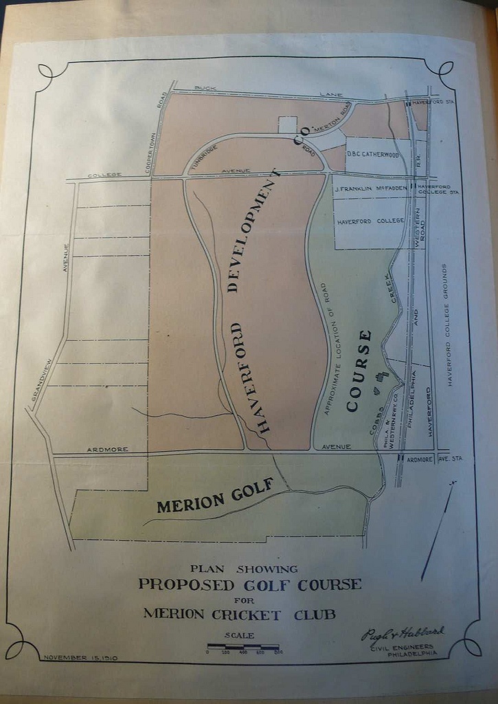
So, the first question is - does the "approximate location of the road actual reflect 117 acres on the map, keeping in mind that Pugh and Hubbard are surveyors and civil engineers and the map is purportedly drawn to scale.

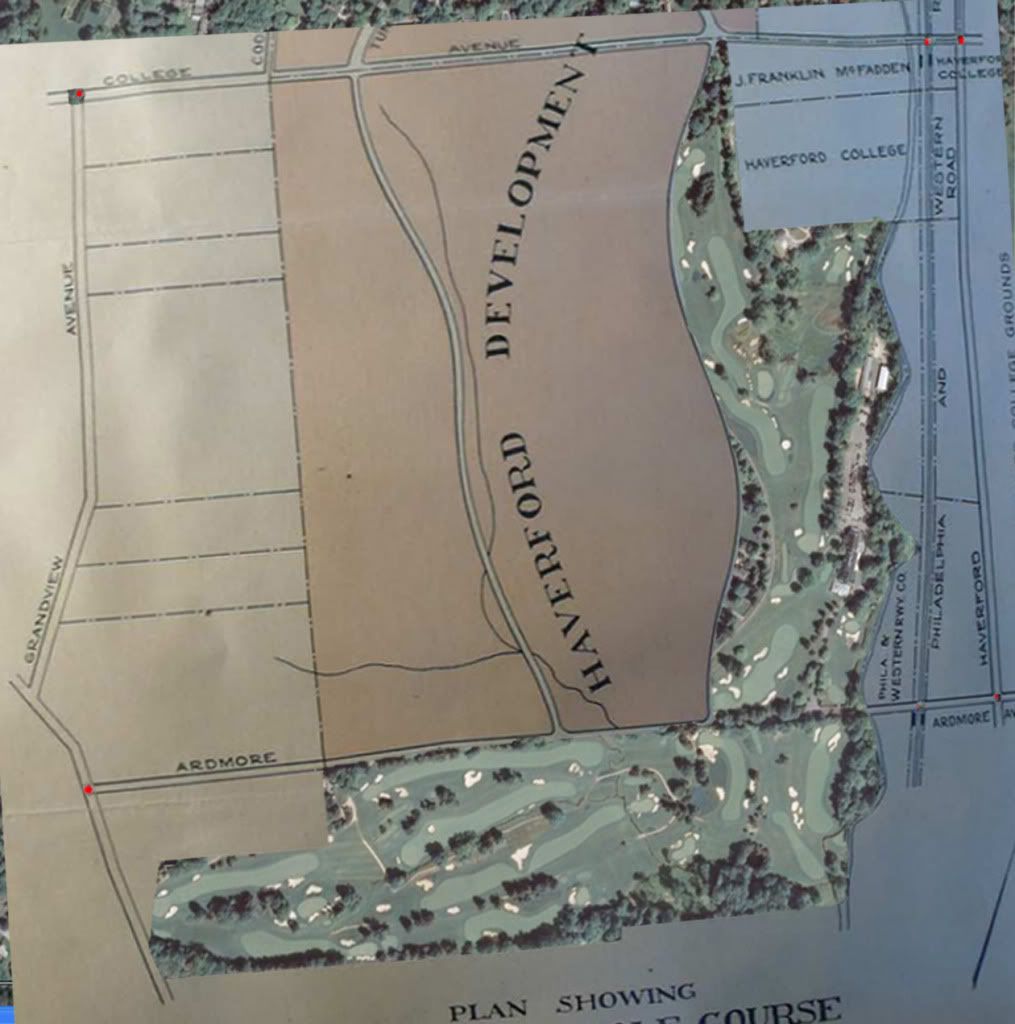
Previously I had distorted the plan of property and overlaid it on the current Google aerial.  I distorted it to try to get the intersection points of roads and RR's to align between the plan and the current aerial.  You can see in the picture below that there are red dots at intersections.  Those are my matching points.  So, it shouldn't be too bad in terms of ts location.


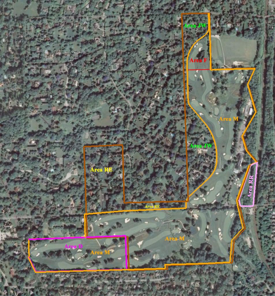
Here is my current picture showing the metes and bounds of the actual July 26, 1911 Indenture.  The boundaries, apart from GHR align pretty well with the overlay above.


Also, previously I had done an overlay of the specifics of the routing of the GHR from the plan of property and it's as built location.  See the picture below.


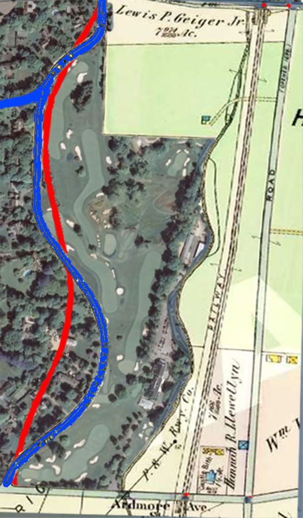
From this picture of the "approximate" alignment of GHR in November 1910 and the as-built alignment in July 26, 1911, I would make the following observations:

From the July 26, 1911 and looking backward, MCC appears to have gained a small area down near the junction of GHR and Ardmore, and lost a little area near the intersection of GHR and College.  Both areas are small and I'd consider them a wash.

Opposite the clubhouse, MCC appears to have gained some area looking back to the "approximate" location of GHR.  I'd estimate it at 6 acres.

Along the 14th and 15th fairways, looking backwards, they appear to have lost some area - I'd estimate at 2 acres.

So, from the July 26, 1911 perspective they had 120.01 acres and moving backward to November 15, 1910, they gained 6 acres and lost 2 acres.

That suggests that the plan of property map puts the area of the "Golf Course" at about 124 acres.  That directly contradicts the Board's letter that says it's 117 acres.

So, there's the conundrum.  We have two documents from the same mailing that contradict each other.  Which is right?


Tony_Chapman

  • Karma: +0/-0
Re: The Merion Timeline - Now with Metes & Bounds
« Reply #1556 on: June 13, 2009, 02:02:28 PM »
Bryan -- I think I'm reading this backwards from how you describe it.

You suggest near the clubhouse that Merion gained six acres (from the Nov. 1910 proposal). I think they lost six acres; considering that the red "proposed" line is further away from the club house than the actual road. Didn't they "give up" all of that land between the approximate road and the actual GHR?

And, if that's the case, doesn't it also mean that up by 14 and 15 they GAINED two acres from the proposal. (This would seem to mesh with Francis' story that they widened the area up there.) And if they gained up top, would that be +2 acres.

That'd mean you had a final of 120.01 acres - 6 lost down below the clubhouse + 2 gained in the widening of 14 and 15 = a proposal to the members of 116 acres on the November 1910 map.

If I'm all dizzy on this please let me know. ;D

Mike_Cirba

Re: The Merion Timeline - Now with Metes & Bounds
« Reply #1557 on: June 14, 2009, 12:38:24 AM »
Bryan,

Are we in agreement that the only place on the property where this final boundary could have been solidified is the northwestern boundary along Golf House Road and are we also in agreement that this HAD to have happened after Nov 1910 and finally, are we also in agreement that the 4.8 acres around 15 green and 16 tee could not have been the swapped land in question?

As much as Patrick doesn't want to see or admit the truth os what the evidence show, I think each of those points are largely irrefuable at this point.

Would you agree?

Patrick_Mucci

Re: The Merion Timeline - Now with Metes & Bounds
« Reply #1558 on: June 14, 2009, 09:54:45 AM »
Mike,

You continue to try to force a square peg into a round hole, but, no matter how many times you insist, no matter how many times you change the title of your thread, your conclusions are flawed.

Please tell me how the metes and bounds proves that Wilson routed and designed Merion.

Thanks

Jeff_Brauer

  • Karma: +0/-0
Re: The Merion Timeline - Now with Metes & Bounds
« Reply #1559 on: June 14, 2009, 11:07:27 AM »
Bryan, Mike, et. al,

As to the acreage differential on the Nov 1910 plan, let me ask you this:

Didn't MCC pick up the acreage where No. 2 green is located later on? I think I recall that. If so, it could simply be a drafting error and that could account for a few acres difference, no?

Another possibility that was touched on earlier, but I don't recall the answer - where exactly does the property line along GHR come out to?  Sometimes, property lines go to the center of roads, not the edges as shown on the Nov 1910 map and the easment is given by both property owners.  Over several thousand feet of 50' road Right of Way, that could add up to 2 acres right there. (Approx 3600 lineal feet of road X 25' (half of the ROW) = 90,000 SF or about 2.1 acres)

Bryan's look at the metes and bounds could help you determine that.

I truly hate to throw out more speculation here, but I guess I just had to!  Sorry if my memory is getting poorer after 10,000 posts on MCC.
Jeff Brauer, ASGCA Director of Outreach

Bryan Izatt

  • Karma: +0/-0
Re: The Merion Timeline - Now with Metes & Bounds
« Reply #1560 on: June 14, 2009, 11:09:34 AM »
Bryan -- I think I'm reading this backwards from how you describe it.  I think not, but let me try again to explain it.

You suggest near the clubhouse that Merion gained six acres (from the Nov. 1910 proposal).   No, I'm suggesting they lost 6 acres from November 15, 1910 and July 26, 1911.  What I wrote in the post above was looking backwards from 1911 to 1910.  I know it's confusing, but we know the answer is in 1911 (120.01 acres), so I was working back from there.  I think they lost six acres; considering that the red "proposed" line is further away from the club house than the actual road. Didn't they "give up" all of that land between the approximate road and the actual GHR?  Yes, they gave up/lost the 6 acres of land between the approximate road and the actual GHR?  That means that on November 15, 1910 the "Golf Course" land must have been greater than 120.01 acres, i.e. 120.01 + 6 acres.

And, if that's the case, doesn't it also mean that up by 14 and 15 they GAINED two acres from the proposal. (This would seem to mesh with Francis' story that they widened the area up there.) And if they gained up top, would that be +2 acres.  Yes, from November 15, 1910 to July 26, 1911 the "Golf Course" lands got bigger by two acres.  That means that on November 15, 1910 it must have been 2 acres smaller than it was on July 26, 1911, i.e. 120.01 +6 -2 = 124.01 acres.

That'd mean you had a final of 120.01 acres - 6 lost down below the clubhouse + 2 gained in the widening of 14 and 15 = a proposal to the members of 116 acres on the November 1910 map.  Nope, I still think I'm right, from 120.01 acres on July 26, 1911 to (120.01 + 6 - 2 = 124.01) on November 15, 1910.  Or, if you prefer, from 124.01 acres on November 15, 1910 - 6 acres + 2 acres = 120.01 acres on July 26, 1911

If I'm all dizzy on this please let me know. ;D  Yes, you're all dizzy, but it's treatable.   ;D  Hope this explanation helped.

Mike_Cirba

Re: The Merion Timeline - Now with Metes & Bounds
« Reply #1561 on: June 14, 2009, 11:23:34 AM »
Bryan,

It sounds to me like we're in agreement...would you conclude the same as per my 3 questions above?

Bryan Izatt

  • Karma: +0/-0
Re: The Merion Timeline - Now with Metes & Bounds
« Reply #1562 on: June 14, 2009, 11:26:39 AM »
Bryan, Mike, et. al,

As to the acreage differential on the Nov 1910 plan, let me ask you this:

Didn't MCC pick up the acreage where No. 2 green is located later on? I think I recall that. If so, it could simply be a drafting error and that could account for a few acres difference, no?  There was a land swap around the 2nd green and 6th fairway in 1912, but it was only 0.352 acres and didn't impinge the 2nd green.  It was ostensibly to provide relief from having to drive over the corner of the Eaton estate on the 6th tee.

Another possibility that was touched on earlier, but I don't recall the answer - where exactly does the property line along GHR come out to?  Sometimes, property lines go to the center of roads, not the edges as shown on the Nov 1910 map and the easment is given by both property owners.  Over several thousand feet of 50' road Right of Way, that could add up to 2 acres right there. (Approx 3600 lineal feet of road X 25' (half of the ROW) = 90,000 SF or about 2.1 acres)  The metes from the deeds are indeed along the middle of the road, Ardmore and GHR for example.  There's no way to know, so far, where they were on the 1910 plan of property, although since it was the same surveyor that drew that map as did the July 26, 1911 deed survey, I'd guess that they ran them down the middle of the "approximate" road. In any event it looks like the property owner owned the road as well and "dedicated" it to the Township (according to Tom).  As an interesting sidelight - the boundary of the south-west corner of the Dallas Estate actually crosses Darby Road and then angles north-east diagonally across Darby.  So, at the time I guess Dallas, and then Merion owned a small entire section of Darby road.  The roads are more like 25 feet wide at most, not 50.   

Bryan's look at the metes and bounds could help you determine that.

I truly hate to throw out more speculation here, but I guess I just had to!  Sorry if my memory is getting poorer after 10,000 posts on MCC.

Jeff_Brauer

  • Karma: +0/-0
Re: The Merion Timeline - Now with Metes & Bounds
« Reply #1563 on: June 14, 2009, 11:31:11 AM »
Bryan,

Thanks for the answer. Yes, there is no way to know where they were on the Nov 1910, but they aren't the ones doing the measuring - we are!  When you or Mike came up with the 124 acres on that map, did you measure the edge of the green area, or did you take it to the center of the road?  It would make nearly a 2 acre difference.

And, yes, the roads are only 25' feet wide, but ROW is typically wider, usually to account for drainage ditches, water lines that follow the road, etc.  Are you saying it only showed 25' wide on the surveyors metes and bounds back in those days?
Jeff Brauer, ASGCA Director of Outreach

Bryan Izatt

  • Karma: +0/-0
Re: The Merion Timeline - Now with Metes & Bounds
« Reply #1564 on: June 14, 2009, 11:47:56 AM »
Bryan,

Are we in agreement that the only place on the property where this final boundary could have been solidified is the northwestern boundary along Golf House Road  and are we also in agreement that this HAD to have happened after Nov 1910 and finally, are we also in agreement that the 4.8 acres around 15 green and 16 tee could not have been the swapped land in question?

As much as Patrick doesn't want to see or admit the truth os what the evidence show, I think each of those points are largely irrefuable at this point.

Would you agree?

Mike,

I think that the "rush to judgment" has happened too frequently on this thread. I'm not ready to reach conclusions yet. 

"Are we in agreement that the only place on the property where this final boundary could have been solidified is the northwestern boundary along Golf House Road"   Which final boundary?  I'd agree that the only boundary that was variable between the 1910 plan of property and the July 26, 1911 deeded 120.01 acres is the boundary along GHR.

"are we also in agreement that this HAD to have happened after Nov 1910Are you referring to the final location of GHR?  No, I can't reach that conclusion yet.  Are we in agreement that the plan of property and the Board's letter to the members are at odds about the 117 acres?  Which is right?  What was going on in the back rooms about the size of the "Golf Course" property and consequently the location of GHR?

"are we also in agreement that the 4.8 acres around 15 green and 16 tee could not have been the swapped land in question"   Which swapped land, in what question?  The Francis swap? The Thompson Resolution swap?  Francis suggested a swap of about 5 acres for the 15th green/16th tee for something adjoining.  That approximately 5 acres is included in the deeded 120.01 acres on July 26, 1911.  It also appears to be there on the plan of property on November 15, 1911.  What do you make of that?

I've got a tee time to make, so discussion to continue later, for me, anyway.

Bryan Izatt

  • Karma: +0/-0
Re: The Merion Timeline - Now with Metes & Bounds
« Reply #1565 on: June 14, 2009, 12:05:13 PM »
Bryan,

Thanks for the answer. Yes, there is no way to know where they were on the Nov 1910, but they aren't the ones doing the measuring - we are!  When you or Mike came up with the 124 acres on that map, did you measure the edge of the green area, or did you take it to the center of the road?  I used the middle of the road on the as-built GHR.  For the "approximate" road, I was guesstimating where it was, so I can't claim that it was exactly middle or edge.  The source material is not that precise.   It would make nearly a 2 acre difference.  I don't think it would in the +6-2 (or -6+2, if you prefer) measurements.  GHR is 3800 feet from Ardmore to College.  The stretches for the +6 and -2 areas are considerably shorter.  In any event, I'm not trying to prove a precise 4 acre delta, just that there is a delta and that it is that the plan of property shows an area that is larger than 117 acres.  I have now got a scanned version on the plan, so I'll try that later to see if I can be more precise taking into account ROW's.

And, yes, the roads are only 25' feet wide, but ROW is typically wider, usually to account for drainage ditches, water lines that follow the road, etc.  Are you saying it only showed 25' wide on the surveyors metes and bounds back in those days?  The metes on the deeds don't address road widths.  They merely state that they went down the middle of the road when they did.  The current GHR measures about 22 feet across the paved areas and about 35 feet to the ROW.  I guess they made narrow gauge roads in PA in the 1910's.  ;)

Jeff_Brauer

  • Karma: +0/-0
Re: The Merion Timeline - Now with Metes & Bounds
« Reply #1566 on: June 14, 2009, 12:12:58 PM »
Bryan,

Narrow Guage roads! I love it.....PA did have a lot of narrow guage railroads at the time. Of course, the most likely explanation is that roads and ROW's generally get wider all the time.  If minor roads are 50' today, I can imagine them being 35' in 1910.

I was once again trying to come up with a definitive explanation.  However, it seems just as likely that the road was simply drawn for ilustrative purposes and that it didn't necessarily have to measure out to the proposed property boundaries, especially since it was known that the road would shift to fit the golf course. 
Jeff Brauer, ASGCA Director of Outreach

John_Cullum

  • Karma: +0/-0
Re: The Merion Timeline - Now with Metes & Bounds
« Reply #1567 on: June 14, 2009, 12:54:31 PM »
Am I incorrect in assuming that at some point in time, the golf course property was actually conveyed to the Club by the developer by a deed.
"We finally beat Medicare. "

Jeff_Brauer

  • Karma: +0/-0
Re: The Merion Timeline - Now with Metes & Bounds
« Reply #1568 on: June 14, 2009, 04:00:31 PM »
John,

Yes and I think the date was July 21, 1911 after all was said and done.
Jeff Brauer, ASGCA Director of Outreach

Rich Goodale

Re: The Merion Timeline - Now with Metes & Bounds
« Reply #1569 on: June 14, 2009, 04:08:48 PM »
John,

Yes and I think the date was July 21, 1911 after all was said and done.

...when all was said and done....  Watch the video version, starting off with Tom Paul walking through the quarry....

http://www.youtube.com/watch?v=aUwS_3QaK-s

Tony_Chapman

  • Karma: +0/-0
Re: The Merion Timeline - Now with Metes & Bounds
« Reply #1570 on: June 14, 2009, 04:12:33 PM »
John -- Jeff is correct on this. The deed that placed the golf course boundary for the 120.01 acres was in July 1911.

I've still no clue to the following. Why did Merion secure 117 acres, send a plan to their members with 124 acres and build a course on 120. Mucci if you think they had this thing routed, I'm going nuts on that one given the differences in the numbers.  ;D

Mike_Cirba

Re: The Merion Timeline - Now with Metes & Bounds
« Reply #1571 on: June 14, 2009, 07:27:01 PM »


I've still no clue to the following. Why did Merion secure 117 acres, send a plan to their members with 124 acres and build a course on 120. Mucci if you think they had this thing routed, I'm going nuts on that one given the differences in the numbers.  ;D

Tony,

Patrick is just wishin', and hopin', and praying that there is some way he can get someone, anyone,  to credit CB Macdonald for Merion, even without a single shard of proof and a timeline that flies in the face of it.   

It's way past ridiculous at this point, and really cluttering these threads with nonsense, frankly.


Rich Goodale

Re: The Merion Timeline - Now with Metes & Bounds
« Reply #1572 on: June 14, 2009, 07:30:46 PM »
"Wishin' and Hopin'" with Pat Mucci playing the part of Dusty Springfield.....

http://www.youtube.com/watch?v=14Dgw_LSJ5w&feature=related
« Last Edit: June 14, 2009, 07:35:04 PM by Rich Goodale »

Mike_Cirba

Re: The Merion Timeline - Now with Metes & Bounds
« Reply #1573 on: June 14, 2009, 07:39:48 PM »

"Are we in agreement that the only place on the property where this final boundary could have been solidified is the northwestern boundary along Golf House Road"   Which final boundary?  I'd agree that the only boundary that was variable between the 1910 plan of property and the July 26, 1911 deeded 120.01 acres is the boundary along GHR.

Good.  Although I do understand you not wanting to rush to judgement, we no doubt agree on this first point. ;D

"are we also in agreement that this HAD to have happened after Nov 1910"  Are you referring to the final location of GHR?  No, I can't reach that conclusion yet.  Are we in agreement that the plan of property and the Board's letter to the members are at odds about the 117 acres?  Which is right?  What was going on in the back rooms about the size of the "Golf Course" property and consequently the location of GHR?

Bryan, I'm surprised you're still hedging on this one.   It's clear that the approximate road drawn on the November 15, 1910 Land Plan is markedly different than the road that was built and shaped according to the final routing and hole dimensions as indicated by the metes and bounds on the July 1911 deed..   It's also clear that the road changed based on adding width where necessary along 14 & 15 and giving back where it wasn't needed, and all of that clearly took place during the time period between November 1910 and July 1911.

"are we also in agreement that the 4.8 acres around 15 green and 16 tee could not have been the swapped land in question"   Which swapped land, in what question?  The Francis swap? The Thompson Resolution swap?  Francis suggested a swap of about 5 acres for the 15th green/16th tee for something adjoining.  That approximately 5 acres is included in the deeded 120.01 acres on July 26, 1911.  It also appears to be there on the plan of property on November 15, 1911.  What do you make of that?

Well, I do think we have a quandary here because the 1910 Land Plan is actually larger than what got built.   No question.

However, I would still stand by my theory that the original land looked at in July 1910 included the northeastern and southern sections of the Johnson Farm in total, which ran from Ardmore Avenue to College Avenue.   Early news accounts talking about the 117 acres also mentioned that the property ran to College Avenue north, so I see no reason to think that this part of the property was ever abbreviated on the northern quadrant, nor has anyone produced anything evidenciary to suggest that.  

I think at some point Lloyd and Connell simply drew a equidistant, curvilinear road up through the Johnson Farm and created what was essentially a "movable boundary", with the general idea being that they'd need about 120 for golf and the rest for real estate.

I think that the 1910 Land Plan was just an estimate of what they'd come up with in the end, and the fact that it's 124 acres (or if it was conversely, 112) doesn't surprise me because I think we are trying to make that boundary into something real when it's "approximate".

We also know that Hugh Wilson and Committee would have later been working with an actual TOPO with a boundary that may or may not have looked precisely like that 1910 Land Plan.  

In any case, whatever they were working with clearly wasn't wide enough and we know that the boundaries of the roadway changed to support the golf course they needed, and I believe it's painfully visually obvious.  EVEN the 1910 Land Plan, which shows MORE ACRES than what was built, SHOWS CLEARLY THAT WHAT THEY WERE CONSIDERING FOR THE FINAL FIVE HOLES WAS NOT WIDE ENOUGH.   :P ;)

That being said, I really do appreciate all of the work you've done here as well as your objectivity.

« Last Edit: June 14, 2009, 11:18:46 PM by MCirba »

Mike_Cirba

Re: The Merion Timeline - Now with Metes & Bounds
« Reply #1574 on: June 14, 2009, 08:15:46 PM »
Let me ask this...

Does anyone think that the curving, equidistant, doppelganger, "mirror" road going up the other side of the lovely hour-glass shape in the HDC development was drawn that way because that ALSO HAPPENED TO CORRESPOND TO AN EXISTING GOLF COURSE ROUTING?!!?!  ::)

Of course, not, that's absolutely preposterous and anyone who would suggest that should rightly have his sanity questioned.   ::) ::) ::)  ;) ;D


Yet we sit here and because of the way Richard Francis remembered the total dimensions of the land they finally came up with on the northernmost part of the property, we still are trying to figure out why an approximate road drawn to show an example of what the golf course dimensions might look like prior to the actual course routing isn't exact!    :o

In fact, if Richard Francis didn't quote the total dimensions of that area in the way he did nearly 40 years after the fact, wouldn't this thread have died out weeks ago?  ???

There is not another single piece of anything resembling fact or evidence left that even remotely places the routing of the golf course prior to that 1910 Land Plan.    :-\


« Last Edit: June 14, 2009, 08:45:48 PM by MCirba »

Tags:
Tags:

An Error Has Occurred!

Call to undefined function theme_linktree()
Back