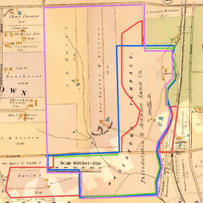
David,
Thanks for producing the following drawing. I think it helps delineate some of the differences in our interpretation of events.

In your interpretation above, you contend that HDC offered Merion
1) All of the Johnson Farm south of Ardmore Avenue
2) All of the Dallas Estate, also south of Ardmore Avenue and contiguous to the Johnson Farm parcel there
3) All of the northeastern portion of the Johnson Farm
but stopping at the border of the Haverford College property, or approximately 65 yards beyond the quarry, although that portion stretches to College Avenue on the north.4) From a separate agreement, the 3 acres of Railroad Land adjacent to the clubhouse originally recommended by M&W.
I would also note that at the time of purchase in 1911 that all of the boundaries lines of the new golf proposed golf course reflected the EXACT HISTORICAL PROPERTY LINES of the A) Johnson Farm, B) Dallas Estate, and C) Railroad Property except for the western boundary of the Johnson Farm above Ardmore Avenue.I note you also did a jig-jag on the property marked as Agnes Smith along Ardmore Avenue, but that transaction didn't occur until late in 1912 after the original purchase.
Is that a fair reflection of your contention?
In response, I've drawn the following crude map of what some of us believe was a more accurate representation of events.
The thick black line shows all the existing borders of the Johnson Farm that were/are used in the land selection.
The light blue lines show the "add-on" parcels, that we believe were just purchased to create more total acreage to work with and includes the Dallas Estate and the Railroad Land.
The THIN black line represents a crude drawing of the original "approximate" land boundary based on the November 1910 Land Plan, where a curvilinear, equidistant, curving road is drawn up through the middle of the northeastern portion of the Johnson Farm
along its entire length north to College Avenue, essentially splitting the sections of HDC land above Ardmore Avenue into areas where north (above the map's boundary) and west of that line would be real estate, and south and east of it would be golf course.

In essance, the overall structure of the entire endeavor results in basically two "L's", almost like conjoined twins, with one atop the other as seen in the 1910 Land Plan.
 With so many historical property boundaries utilized everywhere on the course except the purposefully flexible northwestern boundary line between golf and real estate, it boggles the imagination to think that somehow this is all just a great coincidence, and that this land was purchased in this fashion based on some prior golf course routing that was done before the land was purchased.
If nothing else, I believe the entire disagreement has been distilled down to this, as it seems that even Patrick Mucci agrees that the only remaining point of contention that would lead one to reasonably believe that anyone but Hugh Wilson routed and designed Merion is simply the tiiming and location of the Francis Land Swap.
To me, to believe that Wilson wasn't the designer, one has to take a single phrase of Richard Francis 39 years after the fact where he's describing them fitting in the last five holes and mentions the 130x190 dimension of that triangle area, and essentially discount the entire remainder of his essay, where he describes in self-effacing fashion how he and the rest of the committee "laid out and constructed" Merion, as well as the changes that took place to the course over the years.