News:

This discussion group is best enjoyed using Google Chrome, Firefox or Safari.


TEPaul

Re: My attempt at the Timeline
« Reply #1225 on: June 04, 2009, 10:08:26 AM »
I just added to #1304 for more clarity.

TEPaul

Re: My attempt at the Timeline
« Reply #1226 on: June 04, 2009, 10:24:12 AM »
"Tom,

Wouldn't the area marked "JW" be the same, even if they borrowed some more on the top, they gave back the same amount on the bottom, correct?

I guess the question comes down to finding those mysterious 3 acres they purchased, am I correct?"


We don't need to actually find those three more acres because they were gotten in that same area to the west of Golf House Road somewhere along its entire run from Ardmore to College. We call this Francis thing a swap and apparently he did too since part of it as addressed by the Thompson Resolution was an "exchange" (like for like=equivalency) of land already purchased (within the MCC golf course side on the 1911 contour survey maps on the eastern side of the road) for an exact equivalency of land "adjoining" on the western side of the road on the 1911 contour survey maps AND three additional acres on the western side of the proposed road on the contour survey maps. For the purchase of three "additional" acres the board via the Thomspon Resolution agreed to pay $7,500, the price at the time for HDC residental development land at $2,500 per acre.

This is why and how the land for the course increased by three acres between 1910 and July, 21, 1911.


« Last Edit: June 04, 2009, 10:26:36 AM by TEPaul »

TEPaul

Re: My attempt at the Timeline
« Reply #1227 on: June 04, 2009, 10:34:24 AM »
Furthermore, on Feb, 1, 1911 Hugh Wilson writes to Russell Oakley in part thusly:

    "The Merion Golf Club have purchased one hundred and seventeen (117) acres of land, with the intention of providing a permanent golf course.......I am sending you under separate cover a contour map...."


Does anyone really think the Chairman of the committee charged with designing and building Merion East did not realize the amount of land they had for the golf course had increased from 117 to 120 acres if that Francis land swap that increased the acreage to 120 had happened long before he wrote that letter to Oakley?

Of course not!

TEPaul

Re: My attempt at the Timeline
« Reply #1228 on: June 04, 2009, 10:51:36 AM »
"Quote from: MCirba on Yesterday at 08:52:32 PM
We're arguing nonsense.  

No "special land selected by a previously routed golf course" uses historical property boundary lines around the entire property except in the one instance where a "approximate" boundary is drawn to delineate between the proposed golf course land and a proposed new real estate development.


One of us is.  

The original property was the Johnson farm.   The only parts of it that remained were:

1.  The part adjoining haverford college.  
2.  Maybe the southern border, (but this is in doubt.)
3.  The border the rest of the way around was changed to suit the golf course."


FOR THE RECORD:


The boundary lines (metes and bounds) of the property that would become Merion East golf course was completely identical on the Dec. 19, 1910 deed to Lloyd and the July 21, 1911 deed from Lloyd to MCCGA from the beginning point at College Ave all the way to a point at the corner of the Eaton property and Ardmore Ave (next to the present 2nd green). And that is a provable fact.

Therefore, points #2 and #3 above are incorrect and that too is a provable fact.
« Last Edit: June 04, 2009, 10:54:10 AM by TEPaul »

TEPaul

Re: My attempt at the Timeline
« Reply #1229 on: June 04, 2009, 11:19:31 AM »
Jim Sullivan
Sr. Member

 Offline

Posts: 6535


  Re: My attempt at the Timeline
« Reply #1238 on: Yesterday at 03:50:09 PM » 

--------------------------------------------------------------------------------
Quote from: DMoriarty on Yesterday at 03:40:02 PM

2. The swap mentioned in the April Board Minutes could not possibly refer to the Francis land swap unless the metes provided thus far are substantially off. 


Why not?

DMoriarty

  • Karma: +0/-0
Re: My attempt at the Timeline
« Reply #1230 on: June 04, 2009, 12:15:40 PM »
Jim Sullivan
Sr. Member

 Offline

Posts: 6535


  Re: My attempt at the Timeline
« Reply #1238 on: Yesterday at 03:50:09 PM » 

--------------------------------------------------------------------------------
Quote from: DMoriarty on Yesterday at 03:40:02 PM

2. The swap mentioned in the April Board Minutes could not possibly refer to the Francis land swap unless the metes provided thus far are substantially off. 


Why not?

Provide verifiable facts relating to the April Board Minutes and the borders of the land and I will be glad to show you.

Thanks.
Golf history can be quite interesting if you just let your favorite legends go and allow the truth to take you where it will.
--Tom MacWood (1958-2012)

Mike_Cirba

Re: My attempt at the Timeline
« Reply #1231 on: June 04, 2009, 12:25:30 PM »
They didn't buy some special areas of land for the already routed golf course.   They bought land, and then routed the golf course.


Mike, when you bought your house, did you buy the house, and then figure out later whether your family would fit in it?  Or did you figure that out first?  ;)

Dave,

Are you arguing just to argue?   

They bought approximately the acreage they thought they'd need  to fit a golf course in from existing historical boundaries of both the Johnson Farm and Dallas Estate..

Tom Paul just stated that;

FOR THE RECORD:

The boundary lines (metes and bounds) of the property that would become Merion East golf course was completely identical on the Dec. 19, 1910 deed to Lloyd and the July 21, 1911 deed from Lloyd to MCCGA from the beginning point at College Ave all the way to a point at the corner of the Eaton property and Ardmore Ave (next to the present 2nd green). And that is a provable fact.


But you don't even need to know this...

Just look at the property boundaries on that 1908 map and then look at the land marked as Golf Course on that 1910 Land Plan.

The idea that they routed the golf course on the best land available and then purchased that very special land based on what they first routed is simply insanity and what's more, common sense and your own eyes should tell you better.

What a waste of time.


Or, worse yet, is this still another attempt to create a distraction as we're actually beginning to learn the facts about what land was purchased, and what land was swapped??

How about we just shut the hell up with all of these diversions and let that conversation continue.
« Last Edit: June 04, 2009, 12:32:01 PM by MCirba »

Jeff_Brauer

  • Karma: +0/-0
Re: My attempt at the Timeline
« Reply #1232 on: June 04, 2009, 12:53:14 PM »

FOR THE RECORD:


The boundary lines (metes and bounds) of the property that would become Merion East golf course was completely identical on the Dec. 19, 1910 deed to Lloyd and the July 21, 1911 deed from Lloyd to MCCGA from the beginning point at College Ave all the way to a point at the corner of the Eaton property and Ardmore Ave (next to the present 2nd green). And that is a provable fact.


Okay, correct me if I am wrong, but if the final boundaries of MCC East Course were identical to the 12-19-1910 Deed, then doesn't it prove David's point that the land swap and final routing were prepared prior to that date?
Jeff Brauer, ASGCA Director of Outreach

DMoriarty

  • Karma: +0/-0
Re: My attempt at the Timeline
« Reply #1233 on: June 04, 2009, 12:55:16 PM »
Mike, 

1.  The addition of the Dallas Estate changed the border of the property being considered for a golf course.   The Dallas Estate was not part of the Johnson farm, and was not part of the land originally offered to Merion.   

2.  The land swap along For reasons explained above, the land swap along the border of the Dallas Estate was most likely contemplated in the original plan and carried out informally until the land changed hands again, thus necessitating the formalization of the swap. (I explained this above.)

3.  The RR property was obviously not part of the Johnson farm

4.  The placement of the Golf House road was not on the Johnson farm border.

5.  The Francis land swap altered the border.

As far as I can tell, the only border that was not changed was the border where it would have been impracticable to change - the Johnson farm border with Haverford College, and possibly the southern border.   

One of the many reasons these two deeds will prove to have limited value is that they do not reflect changes that may have been contemplated before July 21, 1911 but not finalized or formalized until after.  The swap mentioned in the April meeting minutes is a example. 

__________________

Jeff_Brauer

Shhhhh . . .
Golf history can be quite interesting if you just let your favorite legends go and allow the truth to take you where it will.
--Tom MacWood (1958-2012)

Mike_Cirba

Re: My attempt at the Timeline
« Reply #1234 on: June 04, 2009, 01:30:46 PM »
Shivas,

That's what I thought...thanks for confirming.

They added the 20 or so acres of the Dallas Estate because they realized they needed more land contiguous and parallel to their existing Johnson farmland that had been allocated for the course.

Even if Barker was a moron, M+W clearly told them they had a very tight fit with what they were looking at.

The wild card and only movable boundary was the northwestern portion of Johnson farm, but keep in mind that every acre there used for golf course drained real estate PROFIT.

That movable boundary illustrated as "approximate location of road" was setup that way on Cuyler's recommendation which gave Lloyd control of both sides of that fence for such an eventuality.

It's not rocket science.

TEPaul

Re: My attempt at the Timeline
« Reply #1235 on: June 04, 2009, 01:57:48 PM »
"The wild card and only movable boundary was the northwestern portion of Johnson farm, but keep in mind that every acre there used for golf course drained real estate PROFIT."


Mike:

No it didn't because MCC agreed to pay the going HDC real estate price ($7,500, $2,500 per acre, 3 acres=$7,500) for the additional three acres they took out of the remaining 221. I guess in the end only 218 got developed but HDC got paid their per acre lot price for that lost three residential acres. At least I hope they did. If not I'm buying about the second half of the 14th hole and I'm gonna sleep in those right greenside bunkers.

DMoriarty

  • Karma: +0/-0
Re: My attempt at the Timeline
« Reply #1236 on: June 04, 2009, 02:01:59 PM »
Mike,

You like graphics so here is the 1908 map which I believe shows what was offered and what they ended up with.  It is obviously not meant to be exact.


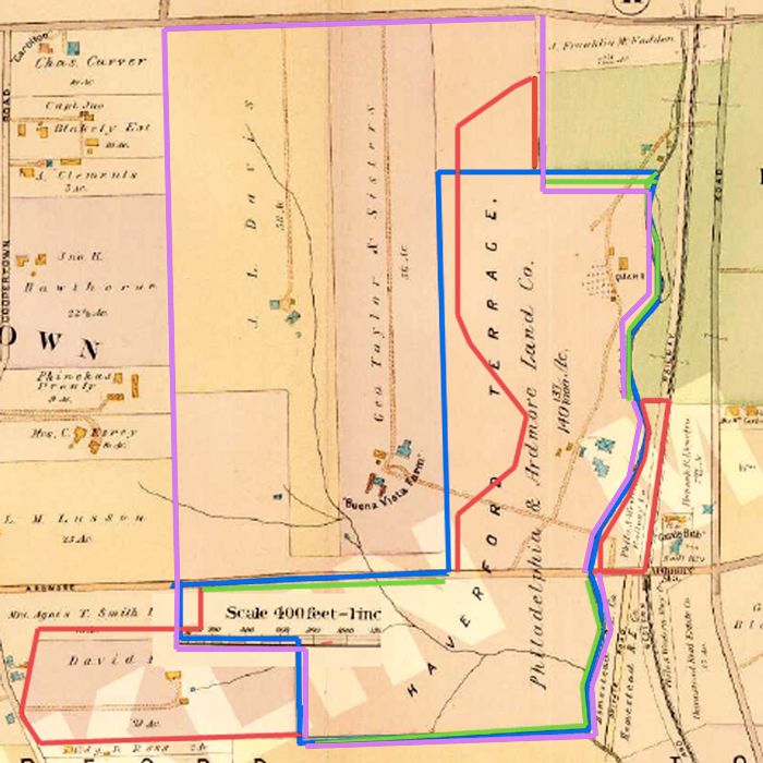
1. The Purple line represents the border of the land that HDC either owned or had an option on at the time they made their offer to MCC (excluding the land off the map to the north)
2. The Blue line represents the border of what I believe were the approx 100 acres that were originally offered.
3. Together, the Red and Green lines represent the borders of what was ultimately purchased by MCC.
   3.a.  The Red lines represents the portions of the border that differed from what was offered.
   3.b.  The Green lines represent the portions of the border that followed what was originally offered.

As you can see, they did NOT follow what was originally offered:

1.   Francis noted that they did not need land west of the present course so they didn't purchase it.
2.   Francis noted that they did need the 130 x 190 yard parcel west of Haverford College so they expanded their purchase up there.   
3.   M&W noted that MCC should purchase the land behind the clubhouse to use in the golf course so the secured that by lease.
4.   HDC owned or had an option on plenty of land West of the current course, but according to Francis they didn't have interest in the land west of the current golf course.  HHB,  M&W, someone else, or some combination added the Dallas Estate which was great. 

These are some of the changes to the borders made to suit the golf course.   I am not even sure why this is arguable.
« Last Edit: June 04, 2009, 02:03:43 PM by DMoriarty »
Golf history can be quite interesting if you just let your favorite legends go and allow the truth to take you where it will.
--Tom MacWood (1958-2012)

TEPaul

Re: My attempt at the Timeline
« Reply #1237 on: June 04, 2009, 02:10:09 PM »
"Mike, I disagree.  I think the insanity is jumping to the conclusion that they certainly and absolutely bought an amount of acreage that they were pretty sure they could build a golf course on without first being certain, particularly when it was going to be as tight a fit as everybody back then must have seen it was going to be.  Now, they may very well have done that, but concluding that they absolutely, positively, certainly did makes no sense to me when there was a more deliberate and logical methodology available to them."


Shivas:

I sure don't want to get into any debate about absolutely, postively, certainly or whatever, but it's pretty clear from all the factual evidence and information that's been emanating out of Merion from back then that that is exactly what they did do. I sure looks to me like Macdonald/Whigam sure made them feel comfortable enough that they had enough good land to get eighteen classic holes on the acreage they proposed buying and they even upped it some from there before submitting their final plan to the board for approval. The thing I find so interesting in this is that obviously they were completely ready with Lloyd in the position he was in if they ever got squeezed anywhere which of course they were with Francis's story. No problem at all---a quick midnight bike ride and instant permission---DONE---top of the quarry drilled off in a day or two.

The way Merion went about it with Wilson and four members designing the course is a very different model anyway, so I can understand how you can't really imagine why they did it all the way they did.

TEPaul

Re: My attempt at the Timeline
« Reply #1238 on: June 04, 2009, 02:14:49 PM »
"Provide verifiable facts relating to the April Board Minutes and the borders of the land and I will be glad to show you."


That's OK, I definitely don't need you to show me anything about Merion, and I was just wondering if you had any idea what you were talking about in that #2 statement you made above. Obviously not! You should probably tell Sully too that you had no idea what you were talking about when he asked you his question about that #2 statement of yours.

« Last Edit: June 04, 2009, 02:17:29 PM by TEPaul »

TEPaul

Re: My attempt at the Timeline
« Reply #1239 on: June 04, 2009, 02:26:31 PM »
"Okay, correct me if I am wrong, but if the final boundaries of MCC East Course were identical to the 12-19-1910 Deed, then doesn't it prove David's point that the land swap and final routing were prepared prior to that date?"


Mr Jeffrey Esq:

Have another cuppa coffee, open your eyes a bit wider and then reread what I said. The boundaries on the two deeds were identically from the beginning point to a particular point (which was next to the 2nd green). That was something like an identical boundary run of maybe 5,000+ thousand yards! From there they were altered. The exercise is to isolate the only area on the property they could've been altered in that Francis land swap fix between Dec. 1910 and July 1911. We've done that now-----eg Golf House Road. Now, if you've gotten that figured out go back to sleep my little Munchkin.


TEPaul

Re: My attempt at the Timeline
« Reply #1240 on: June 04, 2009, 02:33:37 PM »
JeffreyB:

By the way, If you don't feel like explaining it to David Moriarty, that's jake too; believe me I understand; it's incredibly hard work. But if you managed to get him to understand it by 2011, I, for one, will consider nominating you for the teacher of the year!

Phil_the_Author

Re: My attempt at the Timeline
« Reply #1241 on: June 04, 2009, 02:35:14 PM »
This comment addresses only a single point in this discussion, that is, whether the group of men who created the new Merion Golf Club would have simply purchased land they felt would allow for a grand golf course and then try to make one fit it.

This was a COMMON course of action in those days. There are many examples including other courses in the very same area. Let me give you an example. The Philadelphia Cricket Club at Wiisahickon.

The club purchased enough land to design and build TWO golf courses on and planned to finance it by selling off the leftover for use as home sites and housing tracts. It was only after they did this that Tilly designed the two new courses. only one of which would be built. The membership ended up waiting just a wee bit of time for the other one which Messrs. Hurdzan & Fry created.

They would end up selling very little of the land in the 1920's through the 1940's as a result of the market crash, Great Depression and that skirmish we refer to as WW II.

They almost lost the club due to economic pressures, yet today it stands as a firm & strong one with a great membership who appreciates both great courses that are there.

The point is that we have developed a mentality of what is the correct & right way of going about business and real estate purchases that simply weren't always done that way back in those years. What may help in these discussions is putting onself in the mentality of the day you're discussing rather than putting those men in ours...

Mike_Cirba

Re: My attempt at the Timeline
« Reply #1242 on: June 04, 2009, 02:49:18 PM »
Philip,

Of course, and this was done ALL of the time.  In fact, it's how it mostly happens to this day.

No matter how my position on NGLA was misrepresented, the fact is that Macdonald did almost the exact same thing at NGLA.

Out of 400+ acres, he optioned to buy 205 acres; what he thought was enough for both golf course (he estimated to be at 110 acres) and a real estate component for early subscribers (roughly 100 acres).

Although it turned out his original estimation was way off, inevitably the very wide course he laid out was/is somewhere between 150-180 acres of golf-related usage, he still ended up having to buy the 205 acres.

And yes, he kept the boundaries "soft" until he spent 5 months or more routing the golf course after committing to buy 200 acres of the 400 and then made sure the 200 acres he was on the hook to buy included all of that land he needed for the golf course.

To pretend that the Merion buy was exactly like NGLA's is simply a huge exaggeration and bears nothing close to reality.
« Last Edit: June 04, 2009, 02:53:25 PM by MCirba »

TEPaul

Re: My attempt at the Timeline
« Reply #1243 on: June 04, 2009, 02:49:34 PM »
"Tom, I'm not trying to touch on how the course was designed. All I'm pointing out is that it's counterintuitive to believe that these guys would have bought the land first and then just crossed their fingers and hoped that the course would fit later.  It's as counterintuitive as buying a house first and then hoping it fits your family.  And it's particularly counterintuitive when one considers all the high-quality business acumen and intuition of the parties involved."


Shivas:

I understand that. So what? I'm sure there are all kinds of wonderful things that've happened in this world and the way some of them happened may be very counterintuitive to you. So What? They didn't exactly go into this blind, you know, what do you think they got Macdonald/Whigam down from New York on that June day in 1910 to talk to them about? Have you actually read what he wrote them following his visit? If not you should. And they even upped the acreage a bit more from there when they got to routing and designing in the beginning of 1911.

A lot of great things have happened that are counter-intuitive to you. How about that spectacular Indian tribe around Illinois who walked backward everywhere they went and took baths with dirt? That's counter-intuitive right? Well look at how well they did; they were some of the most accomplished people ever known. And how about the Waathafucawee tribe up in Canada just above you? They were some of the best navigators the world has ever seen even though the way they went about it was incredibly counter-intuitive. They virtually proved to humankind that if you never found your way there may be no WAY to find afterall.

TEPaul

Re: My attempt at the Timeline
« Reply #1244 on: June 04, 2009, 03:13:31 PM »
"2.  The land swap along For reasons explained above, the land swap along the border of the Dallas Estate was most likely contemplated in the original plan and carried out informally until the land changed hands again, thus necessitating the formalization of the swap. (I explained this above.)"


MikeC:

It looks like this fellow's constant deceptiveness has taken on a whole new meaning. Do you have any idea at all what he is trying to say there? Is that thing even a sentence? What language does this man use? Is it the language most call "Doubletalk?"


"OBJECTION! Your Honor, nobody has the vaguest idea what this man is trying to say. What language is he using?"

SUSTAINED!!! I believe it is called Moriartese, counselor, and henceforth it will be inadmissable in this court!!

DMoriarty

  • Karma: +0/-0
Re: My attempt at the Timeline
« Reply #1245 on: June 04, 2009, 03:18:26 PM »
Phillip,

I agree that this is what was all too often done, but Merion had a big advantage in that they had M&W advising them and M&W had very definite ideas on figuring out the course first and then buying the land.  This is what they did at NGLA and this appears to be what Merion tried to do at Ardmore.
Golf history can be quite interesting if you just let your favorite legends go and allow the truth to take you where it will.
--Tom MacWood (1958-2012)

Mike_Cirba

Re: My attempt at the Timeline
« Reply #1246 on: June 04, 2009, 03:18:52 PM »
"2.  The land swap along For reasons explained above, the land swap along the border of the Dallas Estate was most likely contemplated in the original plan and carried out informally until the land changed hands again, thus necessitating the formalization of the swap. (I explained this above.)"


MikeC:

It looks like this fellow's constant deceptiveness has taken on a whole new meaning. Do you have any idea at all what he is trying to say there? Is that thing even a sentence? What language does this man use? Is it the language most call "Doubletalk?"


Tom,

Strangely, I do understand exacty what he's trying to say there.

He's saying;

"Tom MacWood keeps harping that I don't minimize HH Barker's contribution to Merion, so the only way I can make that part of the story fit with the rest of my theory and make Barker look anything like a competent architect is to suggest he wouldn't have been anywhere near as stupid and shameless as he must have been to suggest we could build a great golf course on the original 100 acres offered, so I have to pretend that Barker saw and suggested this additional purchase all along."


Trust me on this one.

TEPaul

Re: My attempt at the Timeline
« Reply #1247 on: June 04, 2009, 03:27:02 PM »
"One of the many reasons these two deeds will prove to have limited value is that they do not reflect changes that may have been contemplated before July 21, 1911 but not finalized or formalized until after.  The swap mentioned in the April meeting minutes is a example."


WRONG AGAIN!

Keep it up and you may be able to get a 100% WRONG score! That would actually be pretty impressive! ;)

All the other boundary changes including their separate deeds to Merion East that number over a dozen through the years are all recorded by deed that Merion has all of and all of them are referenced in board meeting minutes as they occured, and most all of them are rather comprehensively explained as to when and why they were done in an abstract. The Thompson Resolution was definitely not the approval for a land swap or boundary adjustment that would come after July 21, 1911. The Thompson Resolution which WAS the Francis land swap was approved on April 19, 1911 and it was reflected perfectly in the July 21, 1911 120.1 acre deed that Lloyd transfered to MCCGA compared to the 117 acre agreement they had previously made with HDC which Hugh Wilson actually MENTIONED (the 117 acres) in a Feb, 1, 1911 LETTER (FACT!!! ;) ) to Russell Oakley.  

You want facts!!?? THOSE are FACTS!!

My God is it becoming more and more apparent the further we get into the details of the history of the place how little you really do know about Merion and how much you rely on unsupportable conjecture and speculation.

« Last Edit: June 04, 2009, 03:35:57 PM by TEPaul »

TEPaul

Re: My attempt at the Timeline
« Reply #1248 on: June 04, 2009, 03:45:09 PM »
I see, so it's HH Barker again, is it? Can you believe that this fellow actually got all over me some time ago because we were never aware of HH Barker and Merion??  ;)

Talk about trying to make something out of nothing!

You know about a year ago Mark Parsinen and I were walking the course following his groups and there was a group right behind us the whole way. When we were on the 17th tee one of the group behind came up on the left of the 16th green and said to me with a wink:

" I think I saw Barker's or Macdonald/Whigam's plans for Merion East under a rock in the quarry."

TEPaul

Re: My attempt at the Timeline
« Reply #1249 on: June 04, 2009, 03:56:27 PM »
Shivas:

Is that Post #1332 supposed to be some analogy to Moriarty? If so, he actually did get one thing right about Merion's history----ie the 1912 trip abroad. It appears he took that single error in Merion's history and attempted to use that to contend that the rest of Merion's history about Wilson was wrong too. Only problem was Moriarty got everything else wrong which ended up by serving the purpose of some of us doing a whole lot of really good research including material at MCC that hadn't been seen in a century that completely proved and reconfirmed that Wilson and his committee routed, designed and built the course with a little help and advice from Macdonald/Whigam on three visits over ten months.

So I guess his almost perfect Blutatsky sort of ended up hitting a homerun for Wilson and his committee! Strange how things work out sometimes, don't you think?  ;)

Tags:
Tags:

An Error Has Occurred!

Call to undefined function theme_linktree()
Back