News:

This discussion group is best enjoyed using Google Chrome, Firefox or Safari.


TEPaul

Re: My attempt at the Timeline
« Reply #1250 on: June 04, 2009, 04:01:39 PM »
 "This is what they did at NGLA and this appears to be what Merion tried to do at Ardmore."


Interesting, even though there is zero factual evidence Merion did that and there is reams of factual evidence they did the opposite. 

DMoriarty

  • Karma: +0/-0
Re: My attempt at the Timeline
« Reply #1251 on: June 04, 2009, 04:26:13 PM »
Can anyone tell me why TEPaul is here? 

It seems he is back into his say something nasty every time Moriarty posts mode.  Does anyone else find this a bit unproductive?
Golf history can be quite interesting if you just let your favorite legends go and allow the truth to take you where it will.
--Tom MacWood (1958-2012)

Phil_the_Author

Re: My attempt at the Timeline
« Reply #1252 on: June 04, 2009, 04:46:07 PM »
Hi David,

I think you misunderstood what i meant. You stated, "Phillip, I agree that this is what was all too often done, but Merion had a big advantage in that they had M&W advising them and M&W had very definite ideas on figuring out the course first and then buying the land.  This is what they did at NGLA and this appears to be what Merion tried to do at Ardmore..."

As I said in my post, I was ONLY addressing the idea that was being stated by some that the proof that MERION didn't purchase their land first and then design the course was because no one would be so foolish to do so. The fact of the matter is that that was really the norm in the early part of the 20th century. In fact, many clubs would first look for land that bordered railroad tracks simply because they could build a stop there for the members convenience. That is what happened at another PA. course nearby, the original Aronimink course designed by Tilly. They bought the land and then Tilly designed the course and along the way they put in a members stop for the train.

The fact is, until we know definitively (definitively that is in this discussion) as to who actually routed & designed Merion, then either method of purchasing the land, as a parcel and then the course or based upon how the course as already routed and basically planned,
could have occurred. That is all I was saying.

Jeff_Brauer

  • Karma: +0/-0
Re: My attempt at the Timeline
« Reply #1253 on: June 04, 2009, 04:52:22 PM »
"Okay, correct me if I am wrong, but if the final boundaries of MCC East Course were identical to the 12-19-1910 Deed, then doesn't it prove David's point that the land swap and final routing were prepared prior to that date?"


Mr Jeffrey Esq:

Have another cuppa coffee, open your eyes a bit wider and then reread what I said. The boundaries on the two deeds were identically from the beginning point to a particular point (which was next to the 2nd green). That was something like an identical boundary run of maybe 5,000+ thousand yards! From there they were altered. The exercise is to isolate the only area on the property they could've been altered in that Francis land swap fix between Dec. 1910 and July 1911. We've done that now-----eg Golf House Road. Now, if you've gotten that figured out go back to sleep my little Munchkin.


Mr. Paul,

So the beginning point of the metes and bounds started near Haverford College on College Blvd. and ran along the creek/railroad side clockwise, across Ardmore, up to the Dallas Estate and then back to Ardmore at about the second green?  

And, then after that, the metes and bounds change from the two deeds? (Which would be East on Ardmore to Golf House Road, up the road itself and then to the infamous triangle, but only on the second deed?

If I hear you right, I am still not sure what that proves, because I think we all know its in and around Golf House Road that the final boundary was set.  But, I guess I would need to see what the differences between the changed areas were and I think that is what we are all waiting for, no?
Jeff Brauer, ASGCA Director of Outreach

Mike_Cirba

Re: My attempt at the Timeline
« Reply #1254 on: June 04, 2009, 04:53:57 PM »
Shivas,

You sound like me.

The real question, and certainly one of greater import than the Francis Land Swap, is simply whether we were more productive and effective at present, or back then. 

DMoriarty

  • Karma: +0/-0
Re: My attempt at the Timeline
« Reply #1255 on: June 04, 2009, 05:48:53 PM »
Shivas,

Your story is changing almost as fast as TEPaul's explanation of the Francis Landswap!   Are you sure you weren't the professor?   
Golf history can be quite interesting if you just let your favorite legends go and allow the truth to take you where it will.
--Tom MacWood (1958-2012)

Mike_Cirba

Re: My attempt at the Timeline
« Reply #1256 on: June 04, 2009, 05:51:13 PM »
David,

Now THAT's funny!  ;D

TEPaul

Re: My attempt at the Timeline
« Reply #1257 on: June 04, 2009, 08:38:46 PM »
"If I hear you right, I am still not sure what that proves, because I think we all know its in and around Golf House Road that the final boundary was set.  But, I guess I would need to see what the differences between the changed areas were and I think that is what we are all waiting for, no?"


Jeffrey:

What it proves is that area---eg the entire extension of what became Golf House Road is the only place on the property the Francis land swap fix could have happened.

It's always hard for me to know what others on here think, and it seems some think this Francis swap could have happened somewhere on the property other than along the PROPOSED Golf House Road. I have proven that there is nowhere else it could have happened.

The next item on the agenda is what the FACTS surrounding MCC then suggest about WHEN it happened and WHEN it could not have happened! A guy like Moriarty will do anything he possibly can to deflect the discussion away from when this happened and when it virtually could not have happened and the reasons why. If he doesn't continue to do that he knows perfectly well the entire "house of cards" logic of his entire essay will come tumbling down!

I certainly do realize that a lot of people out there are struggling to understand the details of this entire thing and that is precisely what Moriarty has made any mileage on with his essay that he has. That is just not the case with me or Wayne Morrison, we know all these details backwards and forwards and inside and out and we know what Moriarty doesn't know or what he refuses to admit to with the FACTS of what went on back then.

TEPaul

Re: My attempt at the Timeline
« Reply #1258 on: June 04, 2009, 08:57:06 PM »
"Can anyone tell me why TEPaul is here? 
It seems he is back into his say something nasty every time Moriarty posts mode.  Does anyone else find this a bit unproductive?"


I'll explain it. It's very simple. I'm on here to explain to those who don't know very well the details of the history of Merion East every time David Moriarty says something about the history of Merion that is factually inaccurate which he does constantly. There is nothing nasty about that at all. Someone should do it and the fact is there is no one left on here who knows those details half so well as I do.

That's why I'm on these Merion threads.

TEPaul

Re: My attempt at the Timeline
« Reply #1259 on: June 04, 2009, 09:08:06 PM »
David Moriarty said:

"1.   Francis noted that they did not need land west of the present course so they didn't purchase it."

That is technically not correct.


"2.   Francis noted that they did need the 130 x 190 yard parcel west of Haverford College so they expanded their purchase up there."

That is technically not correct. That is not what Francis said. The FACT is by Dec. 19, 1910 Lloyd owned that entire 12.48 block up in there west of the Haverford College and MacFadden property. The other fact is that until 1911 Richard Francis had not been appointed by MCC to do anything at all and Francis said so HIMSELF. To assume that he had been working on the course in 1910 is totally unsupportable conjecture and speculation on Moriarty's part. There is not a single shred of evidence, or informational fact to support that and if he thinks there is let us see him produce it other than his limiting idea of what HIS INTERPRETATION of what he THINKS Francis meant in one limited part of his land swap story! 

TEPaul

Re: My attempt at the Timeline
« Reply #1260 on: June 04, 2009, 09:12:40 PM »
"Shivas,
Your story is changing almost as fast as TEPaul's explanation of the Francis Landswap!"


My explanation of the Francis land swap goes back on this website over a year and it was my own revelation that the Francis land swap story fix had to do with the redelineation of Golf House Road before it was built. And now every single bit of additional information coming to us such as deed metes and bounds that have been found and acquired by us recently is confirming and reconfirming that revelation from over a year ago.

Even the importance of Hugh Wilson's mention of 117 acres for the golf course on Feb. 1, 1911 has been overlooked, ignored or not understood at all in the context of when the Francis land swap idea had to have happened AFTER!!
« Last Edit: June 04, 2009, 09:16:03 PM by TEPaul »

Mike_Cirba

!
« Reply #1261 on: June 04, 2009, 09:48:58 PM »
Even the importance of Hugh Wilson's mention of 117 acres for the golf course on Feb. 1, 1911 has been overlooked, ignored or not understood at all in the context of when the Francis land swap idea had to have happened AFTER!!

Tom,

Yes, I'm sure the chairman of the Construction Committee, or whatever it was called, had no idea how much acreage he was working with.

You know, if the true number was 117 and he said 120, I could think perhaps he might just be rounding up.

But to already own 120 acres, to say 117 is just UNFATHOMABLE.

Especially, if as David suggests, the time when they only had 117 acres was WAY BEFORE WILSON WAS EVEN INVOLVED!  ::) ::) ::)

TEPaul

Re: My attempt at the Timeline
« Reply #1262 on: June 04, 2009, 10:09:51 PM »
Michael:

I have zero idea or interest in what David Moriarty thinks the 120.1 acres on the July 21, 1911 deed came from when everyone knows MCC went into this in Nov and Dec 1910 agreeing to purchase 117 for $85,000.

I mean Moriarty is now trying to rationalize that the Thompson Resolution (Francis land swa) addressed some other land exchange AND purchase of three acres additional that would happen sometime in the future and after July 21, 1910 (and did you notice when he did try to explain it he did it in perhaps the most semantically indeciferable sentence imaginable?). But I sure do know every single one of Merion's boundary adjustments from back then until to date including the board meeting minutes addressing, discussing and approving of them and the textual explanations behind the thinking on most of them on a Merion Abstract. The guy doesn't even have the vaguest idea WHAT the future deed transfers and swaps were anyway. Another good example of how not to try to have an informed opinion and ESSAY on a golf club without FIRST going to it and becoming totally familiar with it in every way----a concept and approach MacWood and Moriarty apparently either don't embrace or just can't manage for some REASON ;)! This is just another good example of "make-it-up-as-you-go" analysis and hope those who don't know the details believe you.

The noose is tightening every day on this irresponsible and arrogant historical revisionist and his fallacious essay and nothing could make me happier!
« Last Edit: June 04, 2009, 10:21:40 PM by TEPaul »

Jeff_Brauer

  • Karma: +0/-0
Re: My attempt at the Timeline
« Reply #1263 on: June 05, 2009, 02:09:21 AM »
TePaul,

Well, I was never under the impression that the swap was anywhere else than along golf house road, and was unaware that anyone else seriously contemplated that. 

BTW, if you go to Mike's first post in this thread, it will tell you who first came up with the notion that the land swap was only a redelineation of Golf House Road!  It wasn't you! :D  That said, your recent revelation that the swap also included 3 acres of purchased land makes me wonder if I was right.  Someone drew a map on here a while back where it looked like the road realignment was about a balance, and then the infamous triangle IMHO came back into play as the three acre parcel.  Of course, that map may not have been dimensionally accurate which is something that might get resolved at some point and perhaps clear things up.

I am not sure how that affects any theory on the timing of the triangle.  The Wilson letter saying 117 acres and the board meeting minutes strongly suggest you are right on the timing.  We would then just have to figure out why that triangle showed even close to what the final configuration was on the Nov 1910 map.  I know Mike C says its purely conceptual, which is correct, and the basis of DM's theory is that is HAD to have some basis in thinking at the time it was drawn, other than to show a road connecting College and Ardmore.
Jeff Brauer, ASGCA Director of Outreach

Mike_Cirba

Re: My attempt at the Timeline
« Reply #1264 on: June 05, 2009, 09:53:12 AM »
David,

Thanks for producing the following drawing.   I think it helps delineate some of the differences in our interpretation of events.


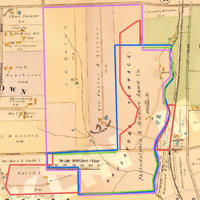
In your interpretation above, you contend that HDC offered Merion

1) All of the Johnson Farm south of Ardmore Avenue
2) All of the Dallas Estate, also south of Ardmore Avenue and contiguous to the Johnson Farm parcel there
3) All of the northeastern portion of the Johnson Farm but stopping at the border of the Haverford College property, or approximately 65 yards beyond the quarry, although that portion stretches to College Avenue on the north.
4) From a separate agreement, the 3 acres of Railroad Land adjacent to the clubhouse originally recommended by M&W.

I would also note that at the time of purchase in 1911 that all of the boundaries lines of the new golf proposed golf course reflected the EXACT HISTORICAL PROPERTY LINES of the A) Johnson Farm, B) Dallas Estate, and C) Railroad Property  except for the western boundary of the Johnson Farm above Ardmore Avenue.

I note you also did a jig-jag on the property marked as Agnes Smith along Ardmore Avenue, but that transaction didn't occur until late in 1912 after the original purchase.

Is that a fair reflection of your contention?


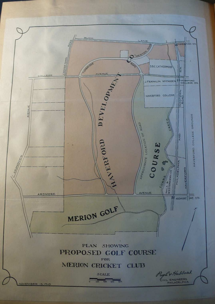
In response, I've drawn the following crude map of what some of us believe was a more accurate representation of events.

The thick black line shows all the existing borders of the Johnson Farm that were/are used in the land selection.

The light blue lines show the "add-on" parcels, that we believe were just purchased to create more total acreage to work with and includes the Dallas Estate and the Railroad Land.

The THIN black line represents a crude drawing of the original "approximate" land boundary based on the November 1910 Land Plan, where a curvilinear, equidistant, curving road is drawn up through the middle of the northeastern portion of the Johnson Farm along its entire length north to College Avenue, essentially splitting the sections of HDC land above Ardmore Avenue into areas where north (above the map's boundary) and west of that line would be real estate, and south and east of it would be golf course.


In essance, the overall structure of the entire endeavor results in basically two "L's", almost like conjoined twins, with one atop the other as seen in the 1910 Land Plan.


With so many historical property boundaries utilized everywhere on the course except the purposefully flexible northwestern boundary  line between golf and real estate, it boggles the imagination to think that somehow this is all just a great coincidence, and that this land was purchased in this fashion based on some prior golf course routing that was done before the land was purchased.

If nothing else, I believe the entire disagreement has been distilled down to this, as it seems that even Patrick Mucci agrees that the only remaining point of contention that would lead one to reasonably believe that anyone but Hugh Wilson routed and designed Merion is simply the tiiming and location of the Francis Land Swap.

To me, to believe that Wilson wasn't the designer, one has to take a single phrase of Richard Francis 39 years after the fact where he's describing them fitting in the last five holes and mentions the 130x190 dimension of that triangle area, and essentially discount the entire remainder of his essay, where he describes in self-effacing fashion how he and the rest of the committee "laid out and constructed" Merion, as well as the changes that took place to the course over the years.


« Last Edit: June 05, 2009, 10:21:34 AM by MCirba »

JESII

  • Karma: +0/-0
Re: My attempt at the Timeline
« Reply #1265 on: June 05, 2009, 10:08:47 AM »
Mike,

More boggling is your contention that the three acres of railroad land was "needed" just to add acres with no consideration of putting a golf hole down there...remember they had 200+ acres to the west if they "just needed a certain amount of acres"...

Mike_Cirba

Re: My attempt at the Timeline
« Reply #1266 on: June 05, 2009, 10:19:12 AM »
Mike,

More boggling is your contention that the three acres of railroad land was "needed" just to add acres with no consideration of putting a golf hole down there...remember they had 200+ acres to the west if they "just needed a certain amount of acres"...

Jim,

I'm not saying they had no consideration of putting a golf hole there at all.  There was a creek to use, it was next to the clubhouse, and it gave them more options where the "L" lines of the property came together, and it gave them clear line to the railroad.   

It would have been very obvous to try and grab that land.

Plus, keep in mind that any more land they used to the west meant loss of potential real estate revenue.


JESII

  • Karma: +0/-0
Re: My attempt at the Timeline
« Reply #1267 on: June 05, 2009, 10:21:53 AM »
To whom? Lloyd?

TEPaul

Re: My attempt at the Timeline
« Reply #1268 on: June 05, 2009, 11:03:58 AM »
"BTW, if you go to Mike's first post in this thread, it will tell you who first came up with the notion that the land swap was only a redelineation of Golf House Road!  It wasn't you!  ;D"


Mr. Jeffrey Brauer, Esq, Sir:


Really? Well aren't I the silly rabbit?! I thought I came up with that idea a year or so ago. Who did come up with it?

TEPaul

Re: My attempt at the Timeline
« Reply #1269 on: June 05, 2009, 11:22:48 AM »
"More boggling is your contention that the three acres of railroad land was "needed" just to add acres with no consideration of putting a golf hole down there...remember they had 200+ acres to the west if they "just needed a certain amount of acres"..."


Sully:

The app 3 acre P&W railroad land it appears they had their eye on too from June 1910. Macdonald in his letter of June 29, 1910 mentioned they should use it. They did use it in the golf course plan that was approved by the board on 4/19/1911.

But that 3 acre P&W RR land did not figure into the three acre increase in total MCC property to 120.1 acres on the July 21, 1911 deed compared to the 117 acres MCC agreed with HDC to buy out of Lloyd's Dec, 19, 1910 161 acre deed.

On July 21, 1911 MCC owned 120.1 acres (not the originally agreed upon 117) but in effect they were using 123 acres for the golf course because they leased that 3 acres from the P&W railroad. We also have the lease agreement of May, 1911 between MCC and the P&W Railroad. That lease would continue until 1961 when Merion G.C. realized they did not own that land. They thought they'd owned it from the beginning. And so in 1961 they bought that app 3 acre P&W land for $11,000. We have that deed too.

JESII

  • Karma: +0/-0
Re: My attempt at the Timeline
« Reply #1270 on: June 05, 2009, 11:28:19 AM »
Tom,

To be perfectly clear, I think it is preposterous to think this crew of men with all the money in the world would nitpick out 117 acres of land out of 340 that they controlled (that's right, I think Lloyd controlled HDC) without a clue as to where the golf holes were going.

This is not to suggest CBM did anything more than has been agreed to, that is not my mission or concern.

TEPaul

Re: My attempt at the Timeline
« Reply #1271 on: June 05, 2009, 11:32:56 AM »
"Plus, keep in mind that any more land they used to the west meant loss of potential real estate revenue."


Mike:

I'm not sure why you keep saying going west of some line (the Proposed Golf House Road?) into some of the proposed 221 acre HDC residential real estate land section was going to be a loss of real estate revenue. It was going to be a loss of available real estate land that eventually got developed into houses but not a loss of revenue to HDC because MCC paid the going residential real estate price for those additional three acres of ground they took. In the end it looks like HDC built out 218 acres rather than 221 but MCC agreed to pay them the going $2,500 per acre residential price for those three acres (in the Thompson Resolution of 4/19/1911).

Jeff_Brauer

  • Karma: +0/-0
Re: My attempt at the Timeline
« Reply #1272 on: June 05, 2009, 11:45:52 AM »
"BTW, if you go to Mike's first post in this thread, it will tell you who first came up with the notion that the land swap was only a redelineation of Golf House Road!  It wasn't you!  ;D"


Mr. Jeffrey Brauer, Esq, Sir:


Really? Well aren't I the silly rabbit?! I thought I came up with that idea a year or so ago. Who did come up with it?

Dear Mr. Paul,

I was wrong, Mike actually gave the credit in post no. 39, quoting from another thread of over a year ago thusly:


I do have to give proper credit to Jeff Brauer, who as a professional architect has likely seen this type of thing prior.   He recognized exactly what happened on the first page of that thread, and said the following;

I don't think the entire 15 Green-16 Tee Triangle was swapped. I think it was enlarged by an acre to partially widen it to 130 yards. It was already 190 yards long.  If the land agreement allowed Merion 120 acres, with the flexibility to take what they needed, then the logical options were to find an acre to give back. or pay HDC for additional another $825 per acre for what might have been wasted land after the club had set a maximum purchase price for itself of $90,000.  Presumably, going back to the well was frowned upon, although I am sure it could have happened.  But it probably would have required new board action to raise funds and they simply wanted to avoid that.


Jeff Brauer, ASGCA Director of Outreach

Bryan Izatt

  • Karma: +0/-0
Re: My attempt at the Timeline
« Reply #1273 on: June 05, 2009, 11:53:29 AM »


I am pleased to report that I now have the deeds and metes and bounds.  It'll take a few days to digest the information, but at least we should have some precise on the ground measurements to guide the discussion/debate.


TEPaul

Re: My attempt at the Timeline
« Reply #1274 on: June 05, 2009, 11:53:52 AM »
"Tom,

"To be perfectly clear, I think it is preposterous to think this crew of men with all the money in the world would nitpick out 117 acres of land out of 340 that they controlled (that's right, I think Lloyd controlled HDC) without a clue as to where the golf holes were going."


Sully:

I know you do; you've said that a number of times. Apparently some others think it is preposterous too. No problem there at all, except all the factual records from MCC point to the fact they just felt they had enough land to build a good 18 hole golf course on (don't forget Macdonald told them so in June 1910 on what appears to have been somewhat less ground) and that they began routing and designing on it beginning in early 1911 and they continued that process with numerous different courses and then five different plans throughout the next three months of the beginning of 1911.

So it really doesn't matter how preposterous you think it is that they did it that way because the MCC records clearly show that is the way they did it. And then one needs to add to that there just isn't anything at all that points to anything finalized with a course or courses before that.

I don't think any of us are saying they had zero idea in 1910 what they would do out there on 117 acres for a golf course when the began routing and designing in the beginning of 1911 only that they did not begin the designing process until the beginning of 1911. That's what the record clearly SHOWS and I for one see no reason to dismiss it and not believe it.

The suggestion that has been thrown around on here by some that all those men from MCC were mistaken or engaging in hyperbole when they recorded what they were doing and when is just pretty much madness and a total waste of time, in my opinion.

I mean, seriously, any joker can take some golf club's historical record and just try to throw it all out as mistaken and wrong when it has never been questioned at any time in a century by anyone and then try to supplant it with a bunch of hypotheticals and conjecture and speculation by trying to torture the hell out of parts of some remarks that some involved back then made years later but what is the point of that really? What's the value of it unless people on here just want to debate endless on a bunch of "WHAT IFS?"


Tags:
Tags:

An Error Has Occurred!

Call to undefined function theme_linktree()
Back